| Locality | Latitude | Longitude | Distance | Bearing |
|---|
| Waterworks tunnel, District of Columbia (Washington D.C.), USA | 38° 55' 27" N | 77° 1' 4" W | 0.0km (0.0 miles) | |
| Piney branch, Rock Creek park, NW Washington, District of Columbia (Washington D.C.), USA | 38° 56' 13" N | 77° 2' 20" W | 2.3km (1.4 miles) | |
| NW Washington, District of Columbia (Washington D.C.), USA | 38° 56' 17" N | 77° 2' 41" W | 2.8km (1.7 miles) | |
| Gneiss outcrop, Rock Creek Park, NW Washington, District of Columbia (Washington D.C.), USA | 38° 56' 0" N | 77° 2' 58" W | 2.9km (1.8 miles) | |
| Rock Creek Park, NW Washington, District of Columbia (Washington D.C.), USA | 38° 56' 8" N | 77° 2' 55" W | 3.0km (1.8 miles) | |
| Constitution Avenue, District of Columbia (Washington D.C.), USA | 38° 53' 33" N | 77° 1' 57" W | 3.7km (2.3 miles) | |
| Soapstone Valley, NW Washington, District of Columbia (Washington D.C.), USA | 38° 56' 44" N | 77° 3' 32" W | 4.3km (2.7 miles) | |
| Bingham branch, Rock Creek Park, NW Washington, District of Columbia (Washington D.C.), USA | 38° 58' 13" N | 77° 3' 2" W | 5.8km (3.6 miles) | |
| 46th street roadcut, NW Washington, District of Columbia (Washington D.C.), USA | 38° 57' 18" N | 77° 5' 26" W | 7.2km (4.4 miles) | |
| Prince Georges Mall, Prince Georges County, Maryland, USA | 38° 58' 10" N | 76° 57' 23" W | 7.3km (4.6 miles) | |
| Bladensburg, Prince Georges County, Maryland, USA | 38° 55' 49" N | 76° 55' 40" W | 7.8km (4.9 miles) | |
| Silver Spring, Montgomery County, Maryland, USA | 38° 59' 44" N | 77° 1' 44" W | 8.0km (5.0 miles) | |
| Bethesda, Montgomery County, Maryland, USA | 38° 59' 6" N | 77° 5' 42" W | 9.5km (5.9 miles) | |
| Capitol Clay Products Company (West Brothers Brick Company), Prince Georges County, Maryland, USA | 38° 54' 32" N | 76° 54' 22" W | 9.8km (6.1 miles) | |
| Wheeler Road, Oxon Hill, Prince Georges County, Maryland, USA | 38° 49' 49" N | 76° 58' 54" W | 10.9km (6.8 miles) | |
| Skaggs Ore Bank, Prince Georges County, Maryland, USA | 38° 59' 39" N | 76° 55' 33" W | 11.1km (6.9 miles) | |
| Reed Ore Bank, Prince Georges County, Maryland, USA | 38° 59' 56" N | 76° 55' 17" W | 11.8km (7.3 miles) | |
| Buck Ore Bank, Prince Georges County, Maryland, USA | 39° 0' 18" N | 76° 55' 8" W | 12.4km (7.7 miles) | |
| Ayrlawn park, Bethesda, Montgomery County, Maryland, USA | 39° 0' 13" N | 77° 7' 8" W | 12.4km (7.7 miles) | |
| Bethesda Mine (Miller Mine), Bethesda, Montgomery County, Maryland, USA | 38° 59' 48" N | 77° 7' 38" W | 12.4km (7.7 miles) | |
| Oxon Creek, Prince Georges County, Maryland, USA | 38° 48' 31" N | 77° 0' 48" W | 12.9km (8.0 miles) | |
| Rock Creek, Montgomery County, Maryland, USA | 39° 1' 17" N | 77° 5' 55" W | 12.9km (8.0 miles) | |
| Wheaton, Montgomery County, Maryland, USA | 39° 2' 22" N | 77° 3' 19" W | 13.2km (8.2 miles) | |
| Riggs Quarry, Garrett Park, Montgomery County, Maryland, USA | 39° 1' 59" N | 77° 4' 59" W | 13.4km (8.3 miles) | |
| Cabin John, Montgomery County, Maryland, USA | 38° 58' 29" N | 77° 9' 31" W | 13.4km (8.3 miles) | |
| Lamberton Branch locality, Silver Spring, Montgomery County, Maryland, USA | 39° 2' 49" N | 77° 0' 37" W | 13.7km (8.5 miles) | |
| Unnamed Schist Quarry Near Cabin John Park (MRDS - 10068002), Cabin John, Montgomery County, Maryland, USA | 38° 58' 48" N | 77° 9' 37" W | 13.8km (8.6 miles) | |
| Garrett Park, Montgomery County, Maryland, USA | 39° 2' 4" N | 77° 5' 42" W | 14.0km (8.7 miles) | |
| Falls Church, Fairfax County, Virginia, USA | 38° 52' 56" N | 77° 10' 15" W | 14.0km (8.7 miles) | |
| Cabin John Creek, Montgomery County, Maryland, USA | 38° 59' 20" N | 77° 9' 33" W | 14.2km (8.8 miles) | |
Minerals recorded nearby (within 14.2 km)
Warning: mysqli::query(): (HY000/3024): Query execution was interrupted, maximum statement execution time exceeded in /home/mindat/www/locsearch_class.php on line 264
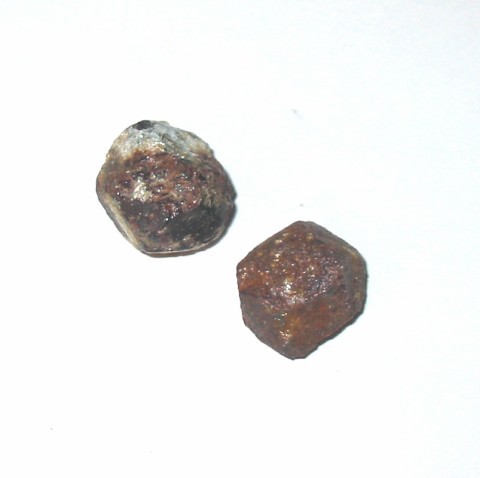
ⓘ 'Biotite'
Rock types recorded nearby (within 14.2 km)
Entries shown in red are rocks recorded for this region.


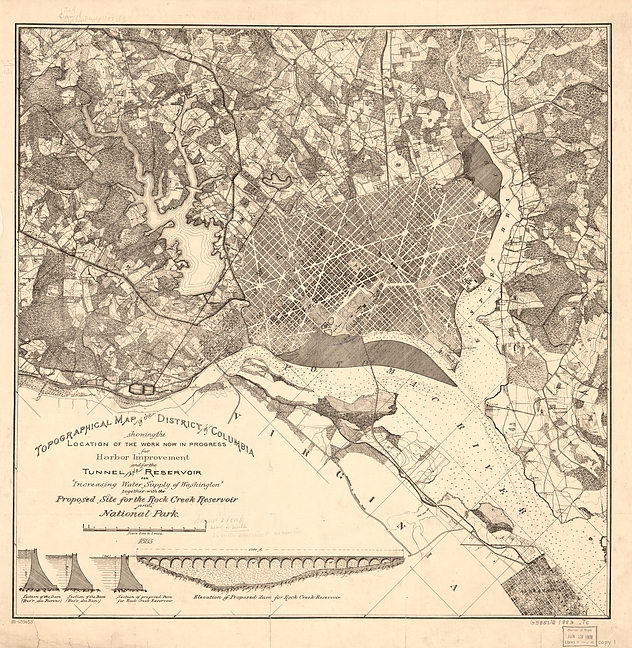


Waterworks tunnel, District of Columbia, USA