| Locality | Latitude | Longitude | Distance | Bearing |
|---|
| Crenver & Wheal Abraham (Abraham Consols; incl. Great Drym Consols), Crowan, Cornwall, England, UK | 50° 9' 24" N | 5° 19' 27" W | 0.0km (0.0 miles) | |
| Wheal Abraham, Crenver & Wheal Abraham (Abraham Consols; incl. Great Drym Consols), Crowan, Cornwall, England, UK | 50° 9' 24" N | 5° 19' 33" W | 0.1km (0.1 miles) | |
| Crenver Mine (Wheal Crenver), Crenver and Oatfield Mine, Crenver & Wheal Abraham (Abraham Consols; incl. Great Drym Consols), Crowan, Cornwall, England, UK | 50° 9' 23" N | 5° 19' 0" W | 0.5km (0.3 miles) | |
| Wheal Sarah, Crenver & Wheal Abraham (Abraham Consols; incl. Great Drym Consols), Crowan, Cornwall, England, UK | 50° 9' 29" N | 5° 19' 54" W | 0.6km (0.3 miles) | |
| Wheal Curtis (Wheal Courtis), West Briton Mine (Crowan Consols), Leedstown, Crowan, Cornwall, England, UK | 50° 9' 5" N | 5° 19' 49" W | 0.7km (0.5 miles) | |
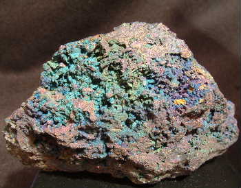
| South Crenver Mine, Crowan, Cornwall, England, UK | 50° 9' 13" N | 5° 18' 46" W | 0.9km (0.6 miles) | |
| Wheal Dumpling, West Briton Mine (Crowan Consols), Leedstown, Crowan, Cornwall, England, UK | 50° 9' 10" N | 5° 20' 18" W | 1.1km (0.7 miles) | |
| Oatfield Mine, Crenver and Oatfield Mine, Crenver & Wheal Abraham (Abraham Consols; incl. Great Drym Consols), Crowan, Cornwall, England, UK | 50° 9' 23" N | 5° 18' 24" W | 1.2km (0.8 miles) | |
| Trenoweth Mine, Crowan, Cornwall, England, UK | 50° 9' 36" N | 5° 18' 26" W | 1.3km (0.8 miles) | |
| Binner Downs Mine, Leedstown, Crowan, Cornwall, England, UK | 50° 9' 32" N | 5° 20' 37" W | 1.4km (0.9 miles) | |
| Wheal Strawberry (Wheal Julia), West Briton Mine (Crowan Consols), Leedstown, Crowan, Cornwall, England, UK | 50° 9' 16" N | 5° 20' 43" W | 1.5km (0.9 miles) | |
| Wheal Millet (Wheal Fortescue), Nancegollan, Crowan, Cornwall, England, UK | 50° 8' 36" N | 5° 19' 8" W | 1.5km (0.9 miles) | |
| Wheal Gooseberry, West Briton Mine (Crowan Consols), Leedstown, Crowan, Cornwall, England, UK | 50° 9' 27" N | 5° 20' 57" W | 1.8km (1.1 miles) | |
| Nancegollan Mine, Nancegollan, Crowan, Cornwall, England, UK | 50° 8' 37" N | 5° 18' 16" W | 2.0km (1.3 miles) | |
| Nancegollan, Crowan, Cornwall, England, UK | 50° 8' 31" N | 5° 18' 24" W | 2.1km (1.3 miles) | |
| Polcrebo Downs Mine, Nancegollan, Crowan, Cornwall, England, UK | 50° 9' 2" N | 5° 17' 39" W | 2.3km (1.4 miles) | |
| Leedstown, Crowan, Cornwall, England, UK | 50° 9' 38" N | 5° 21' 21" W | 2.3km (1.4 miles) | |
| Rosewarne Consols, Halancoose, Gwinear-Gwithian, Cornwall, England, UK | 50° 10' 38" N | 5° 19' 51" W | 2.3km (1.5 miles) | |
| Halancoose, Gwinear-Gwithian, Cornwall, England, UK | 50° 10' 39" N | 5° 19' 47" W | 2.4km (1.5 miles) | |
| Wheal Cruett (North Wheal Metal), Nancegollan, Crowan, Cornwall, England, UK | 50° 8' 1" N | 5° 19' 10" W | 2.6km (1.6 miles) | |
| South Parbola Mine (Wheal Jennings; Parbola Mine), Reawla, Gwinear-Gwithian, Cornwall, England, UK | 50° 10' 40" N | 5° 20' 32" W | 2.7km (1.7 miles) | |
| North Wheal Unity, Reawla, Gwinear-Gwithian, Cornwall, England, UK | 50° 10' 23" N | 5° 21' 11" W | 2.7km (1.7 miles) | |
| Godolphin Mine (Godolphin Bal), Godolphin Cross, Breage, Cornwall, England, UK | 50° 8' 31" N | 5° 21' 23" W | 2.8km (1.7 miles) | |
| Wheal Lamin (Wheal Lemin), North Wheal Unity, Reawla, Gwinear-Gwithian, Cornwall, England, UK | 50° 10' 33" N | 5° 21' 2" W | 2.8km (1.8 miles) | |
| Wheal Vrawz, Nancegollan, Crowan, Cornwall, England, UK | 50° 8' 22" N | 5° 17' 40" W | 2.8km (1.8 miles) | |
| Gernick Mine (West Wheal Grenville; incl. South Gernick Mine [Wheal Top]), Trevoole, Crowan, Cornwall, England, UK | 50° 10' 50" N | 5° 18' 30" W | 2.9km (1.8 miles) | |
| Wheal Hopes (Wheal Hope), Trenerth, Gwinear-Gwithian, Cornwall, England, UK | 50° 10' 9" N | 5° 21' 35" W | 2.9km (1.8 miles) | |
| Wheal Lambo, Wheal Tremayne, Fraddam, Gwinear-Gwithian, Cornwall, England, UK | 50° 9' 53" N | 5° 21' 49" W | 2.9km (1.8 miles) | |
| Wheal Prospidnick, Sithney, Cornwall, England, UK | 50° 8' 8" N | 5° 17' 54" W | 3.0km (1.8 miles) | |
| Carzise Consols, Leedstown, Crowan, Cornwall, England, UK | 50° 9' 31" N | 5° 21' 59" W | 3.0km (1.9 miles) | |


Polcrebo Downs Mine, Nancegollan, Crowan, Cornwall, England, UK