| Locality | Latitude | Longitude | Distance | Bearing |
|---|
| Sugarloaf prospect, Mount Hope, Blaxland Co., New South Wales, Australia | 32° 51' 40" S | 145° 51' 38" E | 0.0km (0.0 miles) | |
| Browns lode (South Mount Hope lode), Mount Hope, Blaxland Co., New South Wales, Australia | 32° 52' 40" S | 145° 51' 43" E | 1.9km (1.2 miles) | |
| Comet Mine (Brown lode), Mount Hope, Blaxland Co., New South Wales, Australia | 32° 52' 48" S | 145° 51' 43" E | 2.1km (1.3 miles) | |
| Quarry Hill prospect, Mount Hope, Blaxland Co., New South Wales, Australia | 32° 52' 56" S | 145° 51' 41" E | 2.4km (1.5 miles) | |
| Hodge lode (Blue lode), Mount Hope, Blaxland Co., New South Wales, Australia | 32° 53' 6" S | 145° 51' 37" E | 2.7km (1.7 miles) | |
| Great Central Mine (Great Central Copper Mine; McLernons Opencut), Mount Hope, Blaxland Co., New South Wales, Australia | 32° 53' 6" S | 145° 51' 29" E | 2.7km (1.7 miles) | |
| Mount Hope Copper Mine, Mount Hope, Blaxland Co., New South Wales, Australia | 32° 50' 19" S | 145° 52' 59" E | 3.2km (2.0 miles) | |
| Anomaly 3 prospect, Mount Hope, Blaxland Co., New South Wales, Australia | 32° 53' 35" S | 145° 51' 22" E | 3.6km (2.2 miles) | |
| Great Central South prospect, Mount Hope, Blaxland Co., New South Wales, Australia | 32° 53' 59" S | 145° 51' 17" E | 4.3km (2.7 miles) | |
| Mount Solitary Gold Mine, Mount Hope, Blaxland Co., New South Wales, Australia | 32° 51' 10" S | 145° 54' 45" E | 4.9km (3.1 miles) | |
| Powerline HIll prospect, Mount Hope, Blaxland Co., New South Wales, Australia | 32° 53' 9" S | 145° 54' 46" E | 5.6km (3.5 miles) | |
| Nombinnie prospect (Davis workings), Mount Hope, Blaxland Co., New South Wales, Australia | 32° 50' 23" S | 145° 48' 6" E | 6.0km (3.7 miles) | |
| Mount Solar Mine (Mount Solar Gold prospect), Mount Hope, Blaxland Co., New South Wales, Australia | 32° 55' 7" S | 145° 54' 41" E | 8.0km (5.0 miles) | |
| Eubalong road, Mount Hope, Blaxland Co., New South Wales, Australia | 32° 53' 44" S | 145° 58' 3" E | 10.7km (6.6 miles) | |
| Mount Allen, Blaxland Co., New South Wales, Australia | 32° 44' 35" S | 145° 52' 4" E | 13.1km (8.1 miles) | |
| Mount Allen Copper prospect, Mount Hope, Blaxland Co., New South Wales, Australia | 32° 44' 33" S | 145° 51' 52" E | 13.2km (8.2 miles) | |
| Mount Hope, Blaxland Co., New South Wales, Australia | 32° 45' 15" S | 145° 56' 36" E | 14.2km (8.8 miles) | |
| 05 Anomaly, Mount Hope, Blaxland Co., New South Wales, Australia | 32° 43' 17" S | 145° 53' 30" E | 15.8km (9.8 miles) | |
| Coan Downs prospect, Mount Hope, Blaxland Co., New South Wales, Australia | 32° 43' 31" S | 145° 48' 36" E | 15.8km (9.8 miles) | |
| Coan Copper Mine, Mount Hope, Blaxland Co., New South Wales, Australia | 32° 44' 10" S | 145° 46' 45" E | 15.8km (9.8 miles) | |
| Coan Gonn Peak, Mount Hope, Blaxland Co., New South Wales, Australia | 32° 43' 59" S | 145° 47' 3" E | 15.9km (9.9 miles) | |
| Hope anomaly, Mount Hope, Blaxland Co., New South Wales, Australia | 32° 43' 18" S | 145° 47' 54" E | 16.5km (10.3 miles) | |
| Double Peak Southeastern Mineralisation, Mount Hope, Blaxland Co., New South Wales, Australia | 32° 42' 25" S | 145° 52' 57" E | 17.2km (10.7 miles) | |
| Double Peak Southwestern Mineralisation, Mount Hope, Blaxland Co., New South Wales, Australia | 32° 42' 12" S | 145° 52' 53" E | 17.6km (11.0 miles) | |
| Mount Dromedary Mine (Double Peak Northern mineralisation; Hills Mine), Mount Hope, Blaxland Co., New South Wales, Australia | 32° 41' 47" S | 145° 52' 30" E | 18.3km (11.4 miles) | |
| Chinamans Tank Workings, Mount Allen, Blaxland Co., New South Wales, Australia | 32° 41' 21" S | 145° 51' 19" E | 19.1km (11.9 miles) | |
| Woolshed prospect, Mount Hope, Blaxland Co., New South Wales, Australia | 32° 42' 4" S | 145° 47' 7" E | 19.1km (11.9 miles) | |
| Mount Allen Mine, Mount Allen, Blaxland Co., New South Wales, Australia | 32° 41' 12" S | 145° 53' 58" E | 19.7km (12.2 miles) | |
| BMW anomaly, Mount Hope, Blaxland Co., New South Wales, Australia | 32° 40' 45" S | 145° 48' 47" E | 20.7km (12.9 miles) | |
| Anomaly G prospect, Blaxland Co., New South Wales, Australia | 32° 39' 56" S | 145° 42' 52" E | 25.7km (16.0 miles) | |
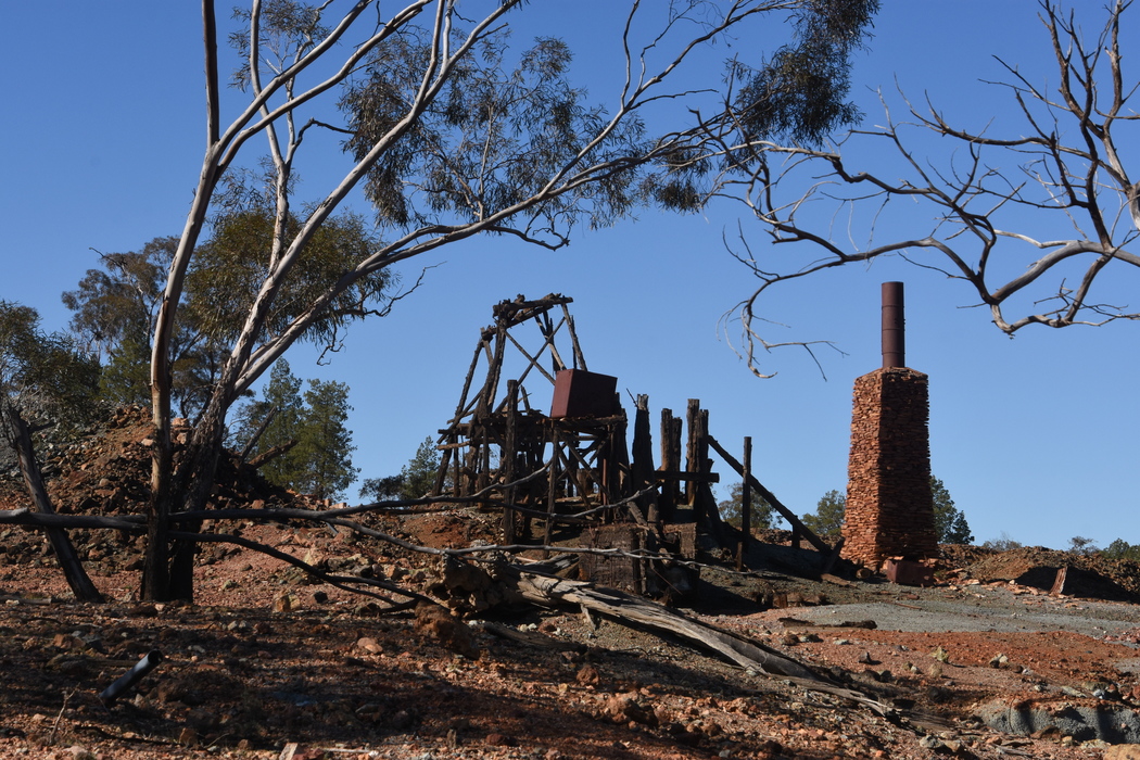


Great Central Mine, Mount Hope, Blaxland Co., New South Wales, Australia