| Locality | Latitude | Longitude | Distance | Bearing |
|---|
| Spearfish, Lawrence County, South Dakota, USA | 44° 29' 26" N | 103° 51' 33" W | 0.7km (0.4 miles) | |
| Spearfish, Trojan Mining District, Lawrence County, South Dakota, USA | 44° 29' 26" N | 103° 51' 33" W | 0.7km (0.4 miles) | |
| Spearfish Sandstone Quarry, Unorganized mining district [3], Lawrence County, South Dakota, USA | 44° 28' 41" N | 103° 52' 13" W | 2.3km (1.4 miles) | |
| Strawberry Hill Mine (2), Lawrence County, South Dakota, USA | 44° 28' 0" N | 103° 52' 0" W | 3.3km (2.0 miles) | |
| Lewis Lime Quarry, Unorganized mining district [3], Lawrence County, South Dakota, USA | 44° 27' 21" N | 103° 51' 19" W | 4.3km (2.7 miles) | |
| National Alabaster Company Mine (Pettigraw Stucow Co-Former Owner), Lawrence County, South Dakota, USA | 44° 32' 29" N | 103° 52' 20" W | 5.5km (3.4 miles) | |
| Spearfish Peak (Black Butte), Spearfish, Lawrence County, South Dakota, USA | 44° 25' 51" N | 103° 51' 16" W | 7.0km (4.4 miles) | |
| Bridalveil Falls (Bridal Veil Falls), Spearfish Canyon, Lawrence County, South Dakota, USA | 44° 25' 0" N | 103° 52' 51" W | 8.9km (5.5 miles) | |
| Spearfish Canyon, Lawrence County, South Dakota, USA | 44° 24' 59" N | 103° 52' 51" W | 8.9km (5.5 miles) | |
| Tetro Rock, Lawrence County, South Dakota, USA | 44° 24' 36" N | 103° 48' 32" W | 10.0km (6.2 miles) | |
| Elliptic Mining Company, Lawrence County, South Dakota, USA | 44° 25' 11" N | 103° 46' 22" W | 10.4km (6.5 miles) | |
| Richmond Hill Mine, Lawrence County, South Dakota, USA | 44° 24' 0" N | 103° 50' 59" W | 10.5km (6.5 miles) | |
| Iron Hill Mine (Richmond Hill; Richmond Hill Manganese; Utica Lode), Spearfish, Lawrence County, South Dakota, USA | 44° 24' 0" N | 103° 50' 59" W | 10.5km (6.5 miles) | |
| Carbonate, Lawrence County, South Dakota, USA | 44° 23' 59" N | 103° 52' 6" W | 10.5km (6.6 miles) | |
| Seabury-Calkins mine, Spearfish, Lawrence County, South Dakota, USA | 44° 23' 51" N | 103° 51' 35" W | 10.7km (6.7 miles) | |
| Segregated Iron Hill mine, Spearfish, Lawrence County, South Dakota, USA | 44° 23' 50" N | 103° 51' 31" W | 10.8km (6.7 miles) | |
| Titanic, Lawrence County, South Dakota, USA | 44° 23' 50" N | 103° 51' 45" W | 10.8km (6.7 miles) | |
| Adelphi Mine, Spearfish, Lawrence County, South Dakota, USA | 44° 23' 50" N | 103° 51' 52" W | 10.8km (6.7 miles) | |
| Eagle Number 4 Mine, Lead Mining District, Lawrence County, South Dakota, USA | 44° 25' 0" N | 103° 46' 11" W | 10.8km (6.7 miles) | |
| Spanish R. mine (Richmond Claim), Spearfish, Lawrence County, South Dakota, USA | 44° 23' 49" N | 103° 52' 4" W | 10.9km (6.7 miles) | |
| Cole Construction Company, Lawrence County, South Dakota, USA | 44° 27' 29" N | 103° 43' 22" W | 11.0km (6.9 miles) | |
| Cleopatra Mine, Lawrence County, South Dakota, USA | 44° 23' 43" N | 103° 52' 47" W | 11.2km (7.0 miles) | |
| Minnesota group (Garden City claim; Big Red claim; Dauntless claim), Lead Mining District, Lawrence County, South Dakota, USA | 44° 23' 56" N | 103° 48' 21" W | 11.2km (7.0 miles) | |
| Victoria Mine, Ragged Top Mining District, Lawrence County, South Dakota, USA | 44° 23' 26" N | 103° 53' 30" W | 11.9km (7.4 miles) | |
| Sundstrom Quarry, Lawrence County, South Dakota, USA | 44° 26' 34" N | 103° 42' 57" W | 12.2km (7.6 miles) | |
| H Clay Production Grog Pit, Lawrence County, South Dakota, USA | 44° 30' 23" N | 103° 41' 54" W | 12.3km (7.6 miles) | |
| Maitland Mine (Realization Mine; Penobscot Mine - Lawrence County; Garden City; Keystone), Lead Mining District, Lawrence County, South Dakota, USA | 44° 23' 29" N | 103° 47' 42" W | 12.3km (7.6 miles) | |
| Maitland Mine (Realization Mine; Penobscot Mine - Lawrence County; Garden City; Keystone), Garden Mining District (Maitland Mining District), Lawrence County, South Dakota, USA | 44° 23' 28" N | 103° 47' 41" W | 12.3km (7.6 miles) | |
| Black Diamond Mine (Black Diamond Group; Spearfish Gold Mining Company), Ragged Top Mining District, Lawrence County, South Dakota, USA | 44° 23' 27" N | 103° 54' 36" W | 12.4km (7.7 miles) | |
| Echo Mine, Lead Mining District, Lawrence County, South Dakota, USA | 44° 23' 11" N | 103° 48' 35" W | 12.4km (7.7 miles) | |
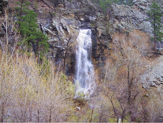


Bridalveil Falls, Spearfish Canyon, Lawrence County, South Dakota, USA