| Locality | Latitude | Longitude | Distance | Bearing |
|---|
| Milchenkar, Gries, Sulz valley, Längenfeld, Imst District, Tyrol, Austria | 47° 3' 20" N | 11° 0' 15" E | 3.3km (2.1 miles) | |
| Eclogite outcrops, Sulz valley, Längenfeld, Imst District, Tyrol, Austria | 47° 3' 38" N | 11° 0' 58" E | 3.8km (2.4 miles) | |
| Köfels, Umhausen, Imst District, Tyrol, Austria | 47° 7' 13" N | 10° 55' 3" E | 6.5km (4.0 miles) | |
| Pirchl gorge, Polles valley, Längenfeld, Imst District, Tyrol, Austria | 47° 0' 33" N | 10° 57' 16" E | 7.3km (4.5 miles) | |
| Ampferkogel, Plangeross-Mandarfen deposit, Sankt Leonhard im Pitztal, Imst District, Tyrol, Austria | 46° 59' 45" N | 10° 54' 31" E | 9.8km (6.1 miles) | |
| Polles valley, Längenfeld, Imst District, Tyrol, Austria | 46° 58' 36" N | 10° 56' 28" E | 11.0km (6.9 miles) | |
| Plangeross-Mandarfen deposit, Sankt Leonhard im Pitztal, Imst District, Tyrol, Austria | 46° 58' 44" N | 10° 52' 9" E | 13.0km (8.1 miles) | |
| Krummer See (Krumpsee), Sankt Leonhard im Pitztal, Imst District, Tyrol, Austria | 47° 5' 6" N | 10° 46' 49" E | 14.4km (8.9 miles) | |
| Schindelbachgraben (Grieskogel), Gries im Sellrain, Innsbruck-Land District, Tyrol, Austria | 47° 10' 8" N | 11° 6' 57" E | 15.3km (9.5 miles) | |
| Schweikert south slope, Verpeil valley, Kaunertal, Landeck District, Tyrol, Austria | 47° 1' 56" N | 10° 46' 24" E | 15.6km (9.7 miles) | |
| Verpeilhütte, Verpeil valley, Kaunertal, Landeck District, Tyrol, Austria | 47° 1' 16" N | 10° 46' 45" E | 15.6km (9.7 miles) | |
| Haderlehen (Knappenlöcher), Sautens, Imst District, Tyrol, Austria | 47° 11' 48" N | 10° 51' 46" E | 15.9km (9.9 miles) | |
| Verpeil valley, Kaunertal, Landeck District, Tyrol, Austria | 47° 1' 45" N | 10° 45' 33" E | 16.7km (10.4 miles) | |
| Boden copper trial, Kaunertal, Landeck District, Tyrol, Austria | 47° 3' 0" N | 10° 45' 6" E | 16.7km (10.4 miles) | |
| Vergötschen, Kaunertal, Landeck District, Tyrol, Austria | 47° 2' 27" N | 10° 45' 7" E | 16.9km (10.5 miles) | |
| Achselkogel, Gries im Sellrain, Innsbruck-Land District, Tyrol, Austria | 47° 9' 35" N | 11° 9' 11" E | 16.9km (10.5 miles) | |
| Tschingl copper mine, Kaunertal, Landeck District, Tyrol, Austria | 47° 1' 25" N | 10° 45' 2" E | 17.5km (10.9 miles) | |
| Tieftal, Kaunertal, Landeck District, Tyrol, Austria | 47° 0' 52" N | 10° 45' 2" E | 17.8km (11.1 miles) | |
| Juifenau, Sellrain, Innsbruck-Land District, Tyrol, Austria | 47° 10' 32" N | 11° 10' 36" E | 19.3km (12.0 miles) | |
| Hochgurgl, Gurgler valley, Sölden, Imst District, Tyrol, Austria | 46° 53' 58" N | 11° 3' 5" E | 20.4km (12.6 miles) | |
| Ranalt quarry, Neustift im Stubaital, Innsbruck-Land District, Tyrol, Austria | 47° 1' 41" N | 11° 13' 47" E | 20.4km (12.7 miles) | |
| Strabag quarry, Roppen, Imst District, Tyrol, Austria | 47° 13' 59" N | 10° 49' 59" E | 20.5km (12.7 miles) | |
| Imst Dike, Wenns, Imst District, Tyrol, Austria | 47° 10' 59" N | 10° 45' 0" E | 20.6km (12.8 miles) | |
| Angerer Alp, Obergurgl, Gurgler valley, Sölden, Imst District, Tyrol, Austria | 46° 53' 51" N | 11° 3' 46" E | 20.8km (12.9 miles) | |
| Timmelsjoch Pass (Rombo Pass), Hochgurgl, Gurgler valley, Sölden, Imst District, Tyrol, Austria | 46° 54' 19" N | 11° 5' 47" E | 21.1km (13.1 miles) | |
| Timmelsjoch (Passo del Rombo), Moos in Passeier (Moso in Passiria), Burggrafenamt (Burgraviato), South Tyrol, Trentino-Alto Adige (Trentino-South Tyrol), Italy | 46° 54' 19" N | 11° 5' 50" E | 21.1km (13.1 miles) | |
| Pb-Zn deposit, Haiming, Imst District, Tyrol, Austria | 47° 14' 47" N | 10° 50' 56" E | 21.2km (13.2 miles) | |
| Schöngrätle lead mine, Kaunertal, Landeck District, Tyrol, Austria | 46° 57' 57" N | 10° 43' 58" E | 21.6km (13.4 miles) | |
| Löchl, Kaunerberg, Landeck District, Tyrol, Austria | 47° 6' 3" N | 10° 41' 2" E | 21.8km (13.6 miles) | |
| Bliggspitze, Kaunertal, Landeck District, Tyrol, Austria | 46° 55' 4" N | 10° 47' 10" E | 22.2km (13.8 miles) | |

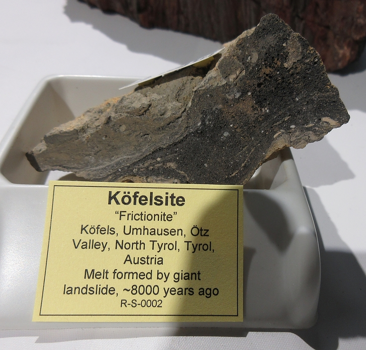


Köfels, Umhausen, Imst District, Tyrol, Austria