| Locality | Latitude | Longitude | Distance | Bearing |
|---|
| Ironwood, Gogebic iron range, Gogebic County, Michigan, USA | 46° 27' 16" N | 90° 10' 15" W | 0.1km (0.1 miles) | |
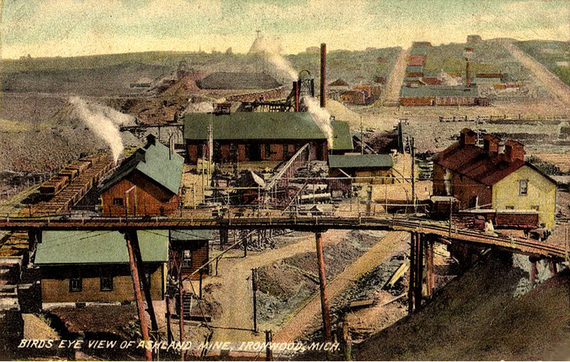
| Ashland Mine, Ironwood, Gogebic iron range, Gogebic County, Michigan, USA | 46° 26' 57" N | 90° 10' 26" W | 0.7km (0.4 miles) | |
| Townsite Mine (Norrie Mine), Ironwood, Gogebic iron range, Gogebic County, Michigan, USA | 46° 26' 44" N | 90° 9' 44" W | 1.3km (0.8 miles) | |
| Germania Mine (Minnewawa; Harmony), Gogebic Range, Iron County, Wisconsin, USA | 46° 26' 47" N | 90° 11' 16" W | 1.5km (0.9 miles) | |
| Penokee Group, Ironwood, Gogebic iron range, Gogebic County, Michigan, USA | 46° 27' 11" N | 90° 8' 52" W | 1.9km (1.2 miles) | |
| Aurora Mine, Ironwood, Gogebic iron range, Gogebic County, Michigan, USA | 46° 26' 50" N | 90° 8' 55" W | 2.0km (1.3 miles) | |
| Bad River dolomite, Gogebic iron range, Gogebic County, Michigan, USA | 46° 27' 27" N | 90° 8' 29" W | 2.4km (1.5 miles) | |
| Hurley Quarry No. 1, Hurley, Gogebic Range, Iron County, Wisconsin, USA | 46° 28' 15" N | 90° 11' 40" W | 2.4km (1.5 miles) | |
| Pabst Mine, Ironwood, Gogebic iron range, Gogebic County, Michigan, USA | 46° 27' 31" N | 90° 8' 19" W | 2.6km (1.6 miles) | |
| Hurley Quarry No. 2, Hurley, Gogebic Range, Iron County, Wisconsin, USA | 46° 28' 11" N | 90° 12' 12" W | 2.9km (1.8 miles) | |
| Cary Mine (Superior; Tilden; Nimikon; West Cary; Kakagon; Windsor), Hurley, Gogebic Range, Iron County, Wisconsin, USA | 46° 26' 12" N | 90° 12' 11" W | 3.1km (1.9 miles) | |
| Newport Mine (Bonnie Mine), Ironwood, Gogebic iron range, Gogebic County, Michigan, USA | 46° 27' 24" N | 90° 7' 19" W | 3.9km (2.4 miles) | |
| Iron Ore Outcrop Occurrence (MRDS - 10218232), Gogebic iron range, Gogebic County, Michigan, USA | 46° 27' 50" N | 90° 6' 39" W | 4.8km (3.0 miles) | |
| Geneva Mine (Geneva-Davis Mine), Bessemer, Gogebic iron range, Gogebic County, Michigan, USA | 46° 27' 38" N | 90° 6' 24" W | 5.1km (3.2 miles) | |
| Montreal Mine (33 Company Mine; Section 33 Mine), Montreal, Gogebic Range, Iron County, Wisconsin, USA | 46° 25' 41" N | 90° 14' 1" W | 5.6km (3.5 miles) | |
| Puritan Mine (Ruby), Gogebic iron range, Gogebic County, Michigan, USA | 46° 28' 9" N | 90° 5' 13" W | 6.7km (4.2 miles) | |
| Powdermill Creek, Bessemer, Gogebic iron range, Gogebic County, Michigan, USA | 46° 28' 54" N | 90° 4' 45" W | 7.7km (4.8 miles) | |
| Hennepin-Snyder Mine (Pence; Father Hennepin; Snyder; Pence-Hennepin Mine), Gogebic Range, Iron County, Wisconsin, USA | 46° 25' 27" N | 90° 15' 48" W | 7.8km (4.8 miles) | |
| Riverside Road Quarry, Iron County, Wisconsin, USA | 46° 29' 57" N | 90° 15' 6" W | 7.8km (4.8 miles) | |
| Gogebic County Quarries, Gogebic County, Michigan, USA | 46° 30' 45" N | 90° 6' 50" W | 7.8km (4.8 miles) | |
| Dean Mine, Gogebic iron range, Gogebic County, Michigan, USA | 46° 28' 19" N | 90° 4' 5" W | 8.2km (5.1 miles) | |
| Ironton Mine, Peterson Mine, Gogebic iron range, Gogebic County, Michigan, USA | 46° 28' 18" N | 90° 4' 2" W | 8.3km (5.1 miles) | |
| Jackpot, Gogebic iron range, Gogebic County, Michigan, USA | 46° 28' 23" N | 90° 4' 2" W | 8.3km (5.2 miles) | |
| Iron Ore Outcrop Occurrence (MRDS - 10170865), Gogebic iron range, Gogebic County, Michigan, USA | 46° 28' 14" N | 90° 3' 56" W | 8.4km (5.2 miles) | |
| Yale, Gogebic iron range, Gogebic County, Michigan, USA | 46° 28' 0" N | 90° 3' 51" W | 8.4km (5.2 miles) | |
| Yale Mine (Valley; Benjamin; West Colby; Yale Jackpot), Yale, Gogebic iron range, Gogebic County, Michigan, USA | 46° 28' 0" N | 90° 3' 45" W | 8.5km (5.3 miles) | |
| Peterson Mine, Gogebic iron range, Gogebic County, Michigan, USA | 46° 28' 17" N | 90° 3' 48" W | 8.6km (5.3 miles) | |
| Colby Mine, Peterson Mine, Gogebic iron range, Gogebic County, Michigan, USA | 46° 28' 23" N | 90° 3' 21" W | 9.2km (5.7 miles) | |
| Bessemer, Gogebic iron range, Gogebic County, Michigan, USA | 46° 28' 53" N | 90° 3' 8" W | 9.7km (6.0 miles) | |
| North Bessemer, Gogebic County, Michigan, USA | 46° 30' 33" N | 90° 3' 59" W | 10.1km (6.3 miles) | |


Ironwood, Gogebic iron range, Gogebic County, Michigan, USA