| Locality | Latitude | Longitude | Distance | Bearing |
|---|
| Roßrugg ridge, Finkenberg, Schwaz District, Tyrol, Austria | 47° 0' 15" N | 11° 48' 33" E | 0.0km (0.0 miles) | |
| Waxegg glacier, Finkenberg, Schwaz District, Tyrol, Austria | 47° 0' 10" N | 11° 47' 31" E | 1.3km (0.8 miles) | |
| Garnet gorge, Finkenberg, Schwaz District, Tyrol, Austria | 47° 1' 19" N | 11° 48' 52" E | 2.0km (1.3 miles) | |
| Horn glacier, Finkenberg, Schwaz District, Tyrol, Austria | 47° 0' 8" N | 11° 50' 14" E | 2.2km (1.3 miles) | |
| Kasten gorge, Finkenberg, Schwaz District, Tyrol, Austria | 47° 1' 26" N | 11° 48' 43" E | 2.2km (1.4 miles) | |
| Dornauberg, Mayrhofen, Schwaz District, Tyrol, Austria | 47° 1' 32" N | 11° 48' 15" E | 2.4km (1.5 miles) | |
| Niedere Barm, Mayrhofen, Schwaz District, Tyrol, Austria | 47° 1' 42" N | 11° 48' 9" E | 2.7km (1.7 miles) | |
| Ultramylonite occurrence, Finkenberg, Schwaz District, Tyrol, Austria | 47° 1' 39" N | 11° 50' 3" E | 3.2km (2.0 miles) | |
| Furtschagl glacier, Finkenberg, Schwaz District, Tyrol, Austria | 46° 59' 31" N | 11° 46' 13" E | 3.2km (2.0 miles) | |
| Furtschaglkar, Schlegeisgrund (Schlegeis valley), Finkenberg, Schwaz District, Tyrol, Austria | 47° 0' 18" N | 11° 45' 41" E | 3.6km (2.2 miles) | |
| Schwarzenstein glacier, Finkenberg, Schwaz District, Tyrol, Austria | 47° 1' 2" N | 11° 51' 13" E | 3.7km (2.3 miles) | |
| Mörchnerkar, Finkenberg, Schwaz District, Tyrol, Austria | 47° 1' 32" N | 11° 50' 46" E | 3.7km (2.3 miles) | |
| Talggenkopf, Finkenberg, Schwaz District, Tyrol, Austria | 47° 0' 48" N | 11° 45' 44" E | 3.7km (2.3 miles) | |
| Pfaffennock, Puster Valley District, South Tyrol, Trentino-Alto Adige (Trentino-South Tyrol), Italy | 46° 58' 16" N | 11° 48' 51" E | 3.7km (2.3 miles) | |
| Grawand Alp, Mayrhofen, Schwaz District, Tyrol, Austria | 47° 1' 59" N | 11° 46' 52" E | 3.9km (2.4 miles) | |
| Diopsidrinne (Schwarzenstein Alp), Mayrhofen, Schwaz District, Tyrol, Austria | 47° 2' 23" N | 11° 49' 19" E | 4.1km (2.5 miles) | |
| Saurüssel, Mayrhofen, Schwaz District, Tyrol, Austria | 47° 2' 8" N | 11° 50' 31" E | 4.3km (2.7 miles) | |
| Schwarzensee lake, Mayrhofen, Schwaz District, Tyrol, Austria | 47° 2' 24" N | 11° 49' 46" E | 4.3km (2.7 miles) | |
| Großer Greiner, Finkenberg, Schwaz District, Tyrol, Austria | 47° 1' 11" N | 11° 45' 13" E | 4.6km (2.8 miles) | |
| Totenkopf, Schlegeisgrund (Schlegeis valley), Finkenberg, Schwaz District, Tyrol, Austria | 47° 0' 21" N | 11° 44' 50" E | 4.7km (2.9 miles) | |
| Schwarzenstein (Schwarzenstein glacier), Mayrhofen, Schwaz District, Tyrol, Austria | 47° 0' 36" N | 11° 52' 25" E | 4.9km (3.1 miles) | |
| Schwarzenstein (Sasso Nero), Ahrntal (Valle Aurina), Puster Valley District, South Tyrol, Trentino-Alto Adige (Trentino-South Tyrol), Italy | 47° 0' 36" N | 11° 52' 26" E | 5.0km (3.1 miles) | |
| Kleiner Mörchner, Mayrhofen, Schwaz District, Tyrol, Austria | 47° 2' 14" N | 11° 51' 24" E | 5.1km (3.2 miles) | |
| Melker Scharte, Mayrhofen, Schwaz District, Tyrol, Austria | 47° 2' 55" N | 11° 49' 56" E | 5.3km (3.3 miles) | |
| Schlegeis glacier, Finkenberg, Schwaz District, Tyrol, Austria | 46° 58' 53" N | 11° 44' 39" E | 5.5km (3.4 miles) | |
| Zsigmondyspitze, Floitengrund, Mayrhofen, Schwaz District, Tyrol, Austria | 47° 3' 1" N | 11° 50' 16" E | 5.6km (3.5 miles) | |
| Forcella di Riotorbo (Trippach), South Tyrol, Trentino-Alto Adige (Trentino-South Tyrol), Italy | 47° 0' 58" N | 11° 53' 14" E | 6.1km (3.8 miles) | |
| Croda Bianca (Weißzint), South Tyrol, Trentino-Alto Adige (Trentino-South Tyrol), Italy | 46° 58' 7" N | 11° 44' 49" E | 6.1km (3.8 miles) | |
| Sonntagsfeld (Sonntaglaner), Floitengrund, Mayrhofen, Schwaz District, Tyrol, Austria | 47° 3' 11" N | 11° 50' 58" E | 6.3km (3.9 miles) | |
| Cima dei Covoni (Tristen peak), Mühlwald (Selva dei Molini), Puster Valley District, South Tyrol, Trentino-Alto Adige (Trentino-South Tyrol), Italy | 46° 56' 39" N | 11° 49' 8" E | 6.7km (4.2 miles) | |
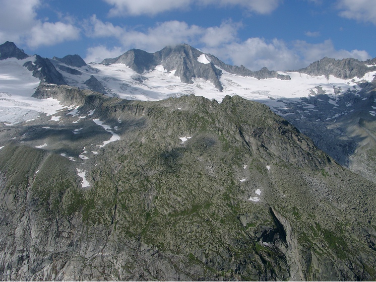


Roßrugg ridge, Finkenberg, Schwaz District, Tyrol, Austria