| Locality | Latitude | Longitude | Distance | Bearing |
|---|
| Hartsteinwerke quarry, Brilon, Hochsauerlandkreis, Arnsberg, North Rhine-Westphalia, Germany | 51° 22' 49" N | 8° 32' 33" E | 0.0km (0.0 miles) | |
| Kraft quarry, Bilstein, Brilon, Hochsauerlandkreis, Arnsberg, North Rhine-Westphalia, Germany | 51° 22' 45" N | 8° 37' 15" E | 5.5km (3.4 miles) | |
| Egon 2 mine, Antfeld, Olsberg, Hochsauerlandkreis, Arnsberg, North Rhine-Westphalia, Germany | 51° 22' 15" N | 8° 27' 42" E | 5.7km (3.5 miles) | |
| Königsgrube, Antfeld, Olsberg, Hochsauerlandkreis, Arnsberg, North Rhine-Westphalia, Germany | 51° 22' 27" N | 8° 27' 37" E | 5.7km (3.6 miles) | |
| Bilstein, Brilon, Hochsauerlandkreis, Arnsberg, North Rhine-Westphalia, Germany | 51° 22' 57" N | 8° 37' 38" E | 5.9km (3.7 miles) | |
| Egon 1 mine, Antfeld, Olsberg, Hochsauerlandkreis, Arnsberg, North Rhine-Westphalia, Germany | 51° 22' 9" N | 8° 27' 29" E | 6.0km (3.7 miles) | |
| Bruchhauser Steine, Bruchhausen, Olsberg, Hochsauerlandkreis, Arnsberg, North Rhine-Westphalia, Germany | 51° 19' 20" N | 8° 32' 39" E | 6.4km (4.0 miles) | |
| Bruchhausen, Olsberg, Hochsauerlandkreis, Arnsberg, North Rhine-Westphalia, Germany | 51° 18' 59" N | 8° 32' 0" E | 7.1km (4.4 miles) | |
| Ostwig Mine, Nuttlar, Bestwig, Hochsauerlandkreis, Arnsberg, North Rhine-Westphalia, Germany | 51° 21' 57" N | 8° 25' 45" E | 8.0km (5.0 miles) | |
| Gottesgabe mine, Wulmeringhausen, Olsberg, Hochsauerlandkreis, Arnsberg, North Rhine-Westphalia, Germany | 51° 18' 57" N | 8° 29' 21" E | 8.0km (5.0 miles) | |
| Wulmeringhausen, Olsberg, Hochsauerlandkreis, Arnsberg, North Rhine-Westphalia, Germany | 51° 18' 50" N | 8° 29' 21" E | 8.3km (5.1 miles) | |
| Pluto Mine, Olsberg, Hochsauerlandkreis, Arnsberg, North Rhine-Westphalia, Germany | 51° 20' 8" N | 8° 26' 48" E | 8.3km (5.1 miles) | |
| Gravel works quarry, Thülen, Brilon, Hochsauerlandkreis, Arnsberg, North Rhine-Westphalia, Germany | 51° 25' 17" N | 8° 39' 1" E | 8.8km (5.4 miles) | |
| Alme quarry, Alme, Brilon, Hochsauerlandkreis, Arnsberg, North Rhine-Westphalia, Germany | 51° 26' 38" N | 8° 37' 0" E | 8.8km (5.4 miles) | |
| Juno Mine, Ramsbeck, Bestwig, Hochsauerlandkreis, Arnsberg, North Rhine-Westphalia, Germany | 51° 19' 0" N | 8° 26' 43" E | 9.8km (6.1 miles) | |
| Luna mine, Wulmeringhausen, Olsberg, Hochsauerlandkreis, Arnsberg, North Rhine-Westphalia, Germany | 51° 17' 57" N | 8° 28' 59" E | 9.9km (6.1 miles) | |
| Dörnberg Mine, Olsberg, Hochsauerlandkreis, Arnsberg, North Rhine-Westphalia, Germany | 51° 18' 56" N | 8° 26' 39" E | 9.9km (6.2 miles) | |
| Bestwig quarry, Bestwig, Hochsauerlandkreis, Arnsberg, North Rhine-Westphalia, Germany | 51° 21' 3" N | 8° 24' 17" E | 10.1km (6.3 miles) | |
| Aurora Mine, Ramsbeck, Bestwig, Hochsauerlandkreis, Arnsberg, North Rhine-Westphalia, Germany | 51° 18' 59" N | 8° 26' 17" E | 10.1km (6.3 miles) | |
| Messinghausen quarry, Messinghausen, Brilon, Hochsauerlandkreis, Arnsberg, North Rhine-Westphalia, Germany | 51° 23' 48" N | 8° 41' 42" E | 10.7km (6.7 miles) | |
| Willibald Mine, Ramsbeck, Bestwig, Hochsauerlandkreis, Arnsberg, North Rhine-Westphalia, Germany | 51° 19' 3" N | 8° 25' 20" E | 10.9km (6.8 miles) | |
| Föckinghausen quarry, Bestwig, Hochsauerlandkreis, Arnsberg, North Rhine-Westphalia, Germany | 51° 22' 15" N | 8° 23' 9" E | 10.9km (6.8 miles) | |
| Diabase quarry, Rühlborn, Ramsbeck, Bestwig, Hochsauerlandkreis, Arnsberg, North Rhine-Westphalia, Germany | 51° 19' 34" N | 8° 24' 20" E | 11.2km (7.0 miles) | |
| Mühlenbein limestone quarry, Rösenbeck, Brilon, Hochsauerlandkreis, Arnsberg, North Rhine-Westphalia, Germany | 51° 25' 8" N | 8° 41' 48" E | 11.5km (7.2 miles) | |
| Brühne quarry, Kallenhardt, Rüthen, Soest, Arnsberg, North Rhine-Westphalia, Germany | 51° 27' 2" N | 8° 24' 56" E | 11.8km (7.3 miles) | |
| Weiken quarry, Kallenhardt, Rüthen, Soest, Arnsberg, North Rhine-Westphalia, Germany | 51° 26' 53" N | 8° 24' 29" E | 12.0km (7.4 miles) | |
| Willibald Mine dumps, Ramsbeck, Bestwig, Hochsauerlandkreis, Arnsberg, North Rhine-Westphalia, Germany | 51° 18' 39" N | 8° 24' 36" E | 12.0km (7.5 miles) | |
| Unnamed limestone quarry, Niederhof, Messinghausen, Brilon, Hochsauerlandkreis, Arnsberg, North Rhine-Westphalia, Germany | 51° 24' 44" N | 8° 42' 29" E | 12.1km (7.5 miles) | |
| Mühlenbein diabase quarry, Niederhof, Messinghausen, Brilon, Hochsauerlandkreis, Arnsberg, North Rhine-Westphalia, Germany | 51° 24' 16" N | 8° 42' 48" E | 12.2km (7.6 miles) | |
| Brunskappel, Olsberg, Hochsauerlandkreis, Arnsberg, North Rhine-Westphalia, Germany | 51° 16' 41" N | 8° 28' 42" E | 12.2km (7.6 miles) | |
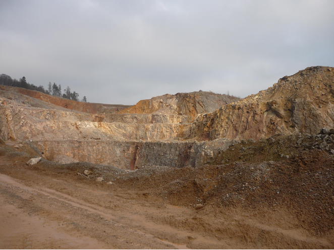


Hartsteinwerke quarry, Brilon, Hochsauerlandkreis, Arnsberg, North Rhine-Westphalia, Germany