| Locality | Latitude | Longitude | Distance | Bearing |
|---|
| Lord Baltimore Drive Quartz occurrence area, Windsor Mill, Baltimore County, Maryland, USA | 39° 19' 49" N | 76° 45' 15" W | 2.3km (1.4 miles) | |
| Windsor Mill, Baltimore County, Maryland, USA | 39° 19' 46" N | 76° 45' 30" W | 2.7km (1.7 miles) | |
| Woodlawn, Baltimore County, Maryland, USA | 39° 18' 53" N | 76° 44' 22" W | 3.3km (2.1 miles) | |
| Patapsco Glen Construction Site, Woodlawn, Baltimore County, Maryland, USA | 39° 18' 50" N | 76° 46' 47" W | 5.2km (3.2 miles) | |
| Bok Asbestos Mine, Hollofield, Baltimore County, Maryland, USA | 39° 19' 5" N | 76° 47' 17" W | 5.5km (3.4 miles) | |
| McMahon Quarry (Greenspring Quarry), Bare Hills, Baltimore County, Maryland, USA | 39° 22' 59" N | 76° 41' 29" W | 5.7km (3.5 miles) | |
| Humphrey Quarry, Baltimore County, Maryland, USA | 39° 19' 0" N | 76° 47' 38" W | 6.0km (3.7 miles) | |
| Wilt Quarry, Baltimore County, Maryland, USA | 39° 19' 0" N | 76° 47' 38" W | 6.0km (3.7 miles) | |
| Northern pit ,Hollofield quarries, Hollofield, Baltimore County, Maryland, USA | 39° 18' 43" N | 76° 47' 31" W | 6.1km (3.8 miles) | |
| Hollofield Feldspar Quarries, Hollofield, Baltimore County, Maryland, USA | 39° 18' 37" N | 76° 47' 32" W | 6.3km (3.9 miles) | |
| Southern pit ,Hollofield quarries, Hollofield, Baltimore County, Maryland, USA | 39° 18' 34" N | 76° 47' 32" W | 6.3km (3.9 miles) | |
| Theis Quarry No. 2, Howard County, Maryland, USA | 39° 18' 42" N | 76° 47' 49" W | 6.5km (4.1 miles) | |
| Theis Quarry No. 1, Howard County, Maryland, USA | 39° 18' 47" N | 76° 47' 54" W | 6.5km (4.1 miles) | |
| Picnic Wood Quarries, Baltimore County, Maryland, USA | 39° 19' 9" N | 76° 48' 11" W | 6.6km (4.1 miles) | |
| French Quarry, Baltimore County, Maryland, USA | 39° 21' 11" N | 76° 48' 46" W | 6.8km (4.2 miles) | |
| Perry Quarries, Howard County, Maryland, USA | 39° 18' 53" N | 76° 48' 15" W | 6.9km (4.3 miles) | |
| Theis Quarry No. 3, Howard County, Maryland, USA | 39° 18' 32" N | 76° 48' 2" W | 6.9km (4.3 miles) | |
| Minckins Quarry, Baltimore County, Maryland, USA | 39° 20' 0" N | 76° 48' 50" W | 6.9km (4.3 miles) | |
| Bare Hills Copper Mine (Smith Avenue Copper Mine), Bare Hills, Baltimore County, Maryland, USA | 39° 22' 39" N | 76° 39' 53" W | 7.0km (4.4 miles) | |
| Highe Quarry No. 1, Howard County, Maryland, USA | 39° 18' 19" N | 76° 47' 56" W | 7.1km (4.4 miles) | |
| Highe Quarry No. 2, Howard County, Maryland, USA | 39° 18' 11" N | 76° 47' 57" W | 7.2km (4.5 miles) | |
| Fagan Quarries, Howard County, Maryland, USA | 39° 18' 21" N | 76° 48' 11" W | 7.3km (4.5 miles) | |
| Discovery workings (Main workings), Bare Hills, Baltimore County, Maryland, USA | 39° 23' 2" N | 76° 39' 44" W | 7.6km (4.7 miles) | |
| Alberton Quarry, Baltimore County, Maryland, USA | 39° 19' 0" N | 76° 49' 0" W | 7.7km (4.8 miles) | |
| Gary Quarry, Howard County, Maryland, USA | 39° 18' 42" N | 76° 48' 51" W | 7.8km (4.8 miles) | |
| Rupp Quarries, Baltimore County, Maryland, USA | 39° 20' 12" N | 76° 49' 31" W | 7.9km (4.9 miles) | |
| Unnamed Chromite prospects, Bare Hills, Baltimore County, Maryland, USA | 39° 23' 7" N | 76° 39' 32" W | 7.9km (4.9 miles) | |
| Streker Quarry, Howard County, Maryland, USA | 39° 18' 2" N | 76° 48' 24" W | 7.9km (4.9 miles) | |
| Bare Hills Serpentine Quarry East, Bare Hills, Baltimore County, Maryland, USA | 39° 23' 12" N | 76° 39' 31" W | 8.0km (5.0 miles) | |
| Bare Hills, Baltimore County, Maryland, USA | 39° 22' 52" N | 76° 39' 12" W | 8.0km (5.0 miles) | |

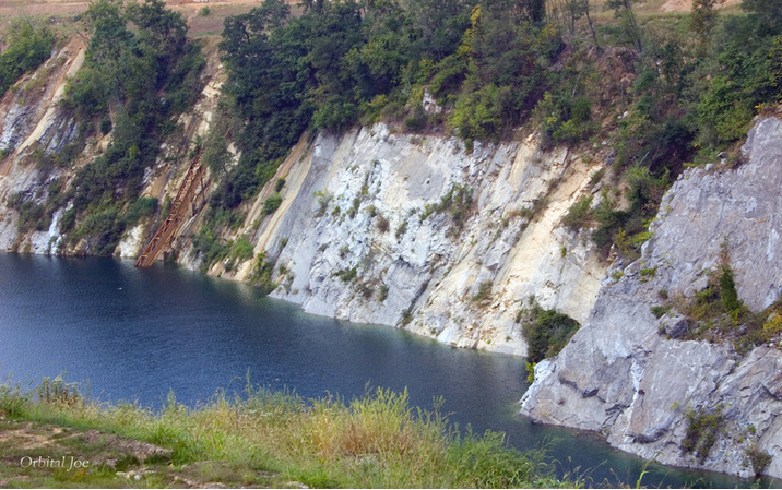

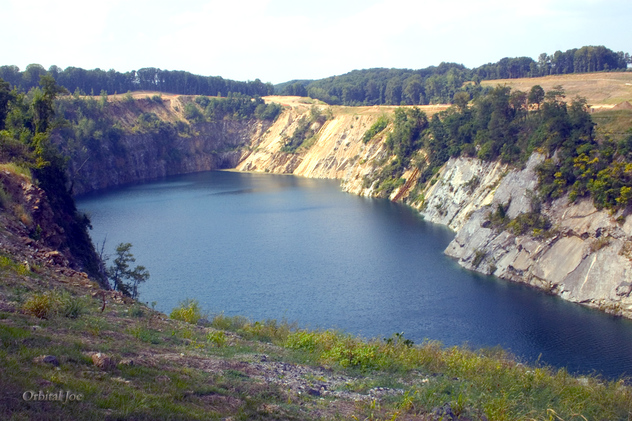
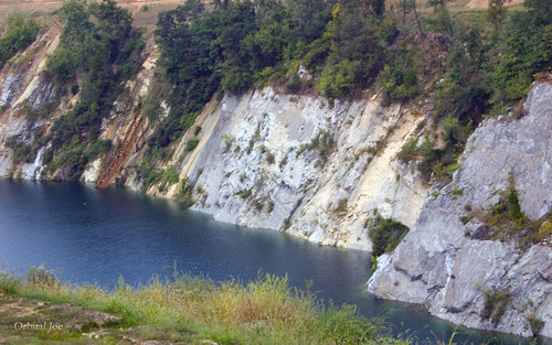


McMahon Quarry, Bare Hills, Baltimore County, Maryland, USA