| Locality | Latitude | Longitude | Distance | Bearing |
|---|
| Nunney Iron Mine, Nunney, Mendip, Somerset, England, UK | 51° 12' 58" N | 2° 22' 41" W | 4.1km (2.6 miles) | |
| Oxley’s Colliery, Buckland Dinham, Mendip, Somerset, England, UK | 51° 15' 21" N | 2° 22' 1" W | 4.4km (2.7 miles) | |
| Whatley Quarry, Whatley, Mendip, Somerset, England, UK | 51° 13' 44" N | 2° 23' 7" W | 4.4km (2.7 miles) | |
| Colemans Quarry, Nunney, Mendip, Somerset, England, UK | 51° 12' 17" N | 2° 23' 32" W | 5.5km (3.4 miles) | |
| Bilboa Colliery, Mells, Mendip, Somerset, England, UK | 51° 14' 39" N | 2° 24' 55" W | 6.7km (4.2 miles) | |
| Mells Colliery, Mells, Mendip, Somerset, England, UK | 51° 14' 57" N | 2° 24' 53" W | 6.9km (4.3 miles) | |
| Vobster Old Colliery, Mells, Mendip, Somerset, England, UK | 51° 14' 20" N | 2° 25' 24" W | 7.2km (4.4 miles) | |
| Vobster Colliery, Mells, Mendip, Somerset, England, UK | 51° 14' 18" N | 2° 25' 35" W | 7.4km (4.6 miles) | |
| Halecombe Quarry, Leigh-on-Mendip, Mendip, Somerset, England, UK | 51° 13' 31" N | 2° 25' 46" W | 7.5km (4.7 miles) | |
| Breach Colliery, Leigh-on-Mendip, Mendip, Somerset, England, UK | 51° 14' 17" N | 2° 26' 5" W | 7.9km (4.9 miles) | |
| Old Newbury Colliery, Coleford, Mendip, Somerset, England, UK | 51° 14' 56" N | 2° 25' 56" W | 8.0km (5.0 miles) | |
| Newbury Old Colliery, Coleford, Mendip, Somerset, England, UK | 51° 14' 56" N | 2° 25' 56" W | 8.0km (5.0 miles) | |
| Newbury Colliery, Coleford, Mendip, Somerset, England, UK | 51° 14' 46" N | 2° 26' 14" W | 8.3km (5.1 miles) | |
| Goodeaves Colliery, Coleford, Mendip, Somerset, England, UK | 51° 14' 34" N | 2° 26' 25" W | 8.4km (5.2 miles) | |
| Mackintosh Colliery, Coleford, Mendip, Somerset, England, UK | 51° 14' 44" N | 2° 26' 36" W | 8.7km (5.4 miles) | |
| Torr Works Quarry, Cranmore, Mendip, Somerset, England, UK | 51° 11' 59" N | 2° 26' 16" W | 8.7km (5.4 miles) | |
| Luckington Colliery, Coleford, Mendip, Somerset, England, UK | 51° 14' 44" N | 2° 26' 37" W | 8.7km (5.4 miles) | |
| Ringing Colliery, Coleford, Mendip, Somerset, England, UK | 51° 14' 35" N | 2° 26' 42" W | 8.7km (5.4 miles) | |
| Kilmersdon Colliery Dump, Radstock, Bath and North East Somerset, England, UK | 51° 15' 42" N | 2° 26' 13" W | 8.8km (5.5 miles) | |
| Coal Barton Pit, Coleford, Mendip, Somerset, England, UK | 51° 14' 27" N | 2° 27' 35" W | 9.7km (6.0 miles) | |
| Foxcote Colliery, Hemington, Mendip, Somerset, England, UK | 51° 17' 42" N | 2° 24' 58" W | 9.9km (6.1 miles) | |
| Huish Colliery, Kilmersdon, Mendip, Somerset, England, UK | 51° 17' 5" N | 2° 26' 6" W | 10.1km (6.3 miles) | |
| Shoscombe Colliery, Bath and North East Somerset, England, UK | 51° 17' 54" N | 2° 25' 10" W | 10.3km (6.4 miles) | |
| Charmborough Colliery, Coleford, Mendip, Somerset, England, UK | 51° 15' 30" N | 2° 27' 45" W | 10.4km (6.4 miles) | |
| Writhlington Colliery, Radstock, Bath and North East Somerset, England, UK | 51° 17' 46" N | 2° 25' 26" W | 10.4km (6.4 miles) | |
| Writhlington Lower Colliery, Radstock, Bath and North East Somerset, England, UK | 51° 17' 46" N | 2° 25' 26" W | 10.4km (6.4 miles) | |
| Edford Colliery, Holcombe, Mendip, Somerset, England, UK | 51° 14' 18" N | 2° 28' 14" W | 10.4km (6.5 miles) | |
| Holcombe Quarry (Cook's Wood Quarry; Cookswood Quarry), Stoke St Michael, Mendip, Somerset, England, UK | 51° 13' 38" N | 2° 28' 18" W | 10.4km (6.5 miles) | |
| Writhlington Upper Colliery, Radstock, Bath and North East Somerset, England, UK | 51° 17' 36" N | 2° 25' 59" W | 10.6km (6.6 miles) | |
| Kilmersdon Colliery, Radstock, Bath and North East Somerset, England, UK | 51° 16' 58" N | 2° 26' 57" W | 10.7km (6.7 miles) | |
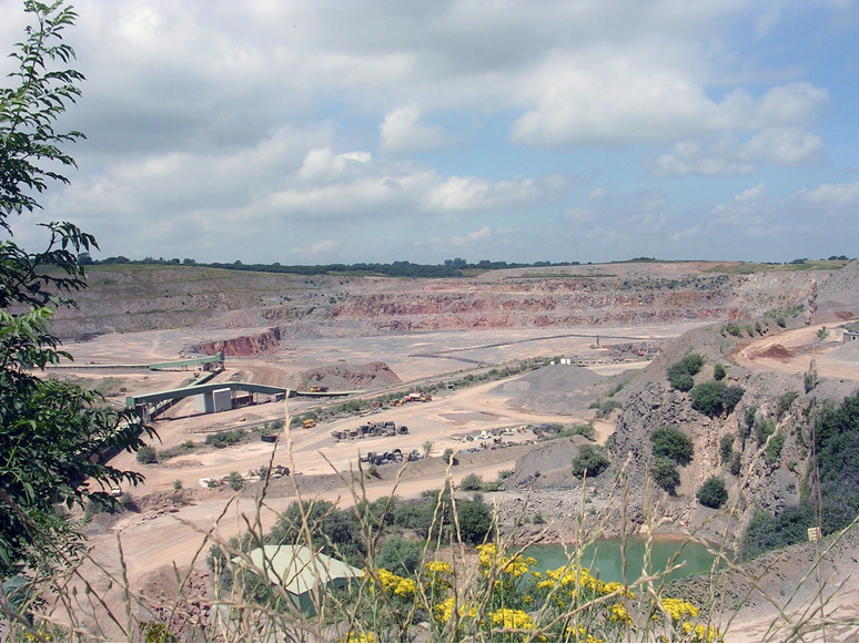


Torr Works Quarry, Cranmore, Mendip, Somerset, England, UK