| Locality | Latitude | Longitude | Distance | Bearing |
|---|
| Police Station Cut, Greenbushes Tinfield, Bridgetown-Greenbushes Shire, Western Australia, Australia | 33° 51' 8" S | 116° 3' 32" E | 0.2km (0.1 miles) | |
| Cornwall North Mine, Greenbushes Tinfield, Bridgetown-Greenbushes Shire, Western Australia, Australia | 33° 51' 9" S | 116° 3' 38" E | 0.2km (0.1 miles) | |
| Cornwall North Mine, Bridgetown-Greenbushes Shire, Western Australia, Australia | 33° 51' 9" S | 116° 3' 38" E | 0.2km (0.1 miles) | |
| Lemonade Springs Cut, Greenbushes Tinfield, Bridgetown-Greenbushes Shire, Western Australia, Australia | 33° 51' 11" S | 116° 3' 41" E | 0.3km (0.2 miles) | |
| Greenbushes Mine, Greenbushes Tinfield, Bridgetown-Greenbushes Shire, Western Australia, Australia | 33° 51' 16" S | 116° 3' 34" E | 0.4km (0.3 miles) | |
| Greenbushes Sn placers, Greenbushes Tinfield, Bridgetown-Greenbushes Shire, Western Australia, Australia | 33° 51' 15" S | 116° 3' 39" E | 0.4km (0.3 miles) | |
| Sunday Gift Mine, Greenbushes Tinfield, Bridgetown-Greenbushes Shire, Western Australia, Australia | 33° 50' 59" S | 116° 3' 55" E | 0.6km (0.4 miles) | |
| Grafter Mine, Bridgetown-Greenbushes Shire, Western Australia, Australia | 33° 51' 4" S | 116° 3' 59" E | 0.7km (0.4 miles) | |
| Great Wonder Mine, Greenbushes Tinfield, Bridgetown-Greenbushes Shire, Western Australia, Australia | 33° 51' 18" S | 116° 3' 55" E | 0.7km (0.5 miles) | |
| South Cornwall Extended Mine, Greenbushes Tinfield, Bridgetown-Greenbushes Shire, Western Australia, Australia | 33° 51' 23" S | 116° 3' 50" E | 0.8km (0.5 miles) | |
| Cornwall North Pit, Bridgetown-Greenbushes Shire, Western Australia, Australia | 33° 51' 1" S | 116° 4' 4" E | 0.8km (0.5 miles) | |
| Gold Coin Mine, Greenbushes Tinfield, Bridgetown-Greenbushes Shire, Western Australia, Australia | 33° 51' 19" S | 116° 3' 59" E | 0.8km (0.5 miles) | |
| New Zealand Mine, Greenbushes Tinfield, Bridgetown-Greenbushes Shire, Western Australia, Australia | 33° 50' 32" S | 116° 3' 41" E | 1.0km (0.6 miles) | |
| Olympia Mine, Greenbushes Tinfield, Bridgetown-Greenbushes Shire, Western Australia, Australia | 33° 50' 36" S | 116° 3' 55" E | 1.0km (0.6 miles) | |
| Greenbushes Central Lode Pit (Cornwall Pit), Greenbushes Mine, Greenbushes Tinfield, Bridgetown-Greenbushes Shire, Western Australia, Australia | 33° 51' 32" S | 116° 3' 56" E | 1.1km (0.7 miles) | |
| Enterprise Mine, Greenbushes Tinfield, Bridgetown-Greenbushes Shire, Western Australia, Australia | 33° 51' 35" S | 116° 4' 2" E | 1.2km (0.8 miles) | |
| Eureka Mine, Greenbushes Tinfield, Bridgetown-Greenbushes Shire, Western Australia, Australia | 33° 51' 33" S | 116° 4' 6" E | 1.3km (0.8 miles) | |
| Foxes lode, Greenbushes Tinfield, Bridgetown-Greenbushes Shire, Western Australia, Australia | 33° 51' 43" S | 116° 4' 29" E | 1.9km (1.2 miles) | |
| New Zealand Gully, Greenbushes Tinfield, Bridgetown-Greenbushes Shire, Western Australia, Australia | 33° 50' 5" S | 116° 3' 2" E | 1.9km (1.2 miles) | |
| New Zealand Gully Mine, Greenbushes Tinfield, Bridgetown-Greenbushes Shire, Western Australia, Australia | 33° 50' 4" S | 116° 3' 0" E | 2.0km (1.2 miles) | |
| Coles Cut, Greenbushes Tinfield, Bridgetown-Greenbushes Shire, Western Australia, Australia | 33° 52' 23" S | 116° 3' 37" E | 2.5km (1.5 miles) | |
| Old Bundbury Mine, Greenbushes Tinfield, Bridgetown-Greenbushes Shire, Western Australia, Australia | 33° 52' 15" S | 116° 4' 18" E | 2.5km (1.6 miles) | |
| Haphazard Mine, Greenbushes Tinfield, Bridgetown-Greenbushes Shire, Western Australia, Australia | 33° 52' 6" S | 116° 4' 38" E | 2.6km (1.6 miles) | |
| You and Me Mine, Greenbushes Tinfield, Bridgetown-Greenbushes Shire, Western Australia, Australia | 33° 51' 57" S | 116° 4' 53" E | 2.7km (1.6 miles) | |
| Berkshine Mine, Greenbushes Tinfield, Bridgetown-Greenbushes Shire, Western Australia, Australia | 33° 52' 13" S | 116° 4' 48" E | 2.9km (1.8 miles) | |
| Caledonian Mine, Greenbushes Tinfield, Bridgetown-Greenbushes Shire, Western Australia, Australia | 33° 52' 28" S | 116° 4' 28" E | 3.0km (1.9 miles) | |
| Southern Cross, Greenbushes Tinfield, Bridgetown-Greenbushes Shire, Western Australia, Australia | 33° 52' 30" S | 116° 4' 35" E | 3.1km (1.9 miles) | |
| Vultan Pit, Greenbushes Tinfield, Bridgetown-Greenbushes Shire, Western Australia, Australia | 33° 52' 34" S | 116° 4' 32" E | 3.2km (2.0 miles) | |
| Ironclad Mine, Greenbushes Tinfield, Bridgetown-Greenbushes Shire, Western Australia, Australia | 33° 52' 46" S | 116° 4' 31" E | 3.5km (2.2 miles) | |
| Queen Victoria Tin Mine, Greenbushes Tinfield, Bridgetown-Greenbushes Shire, Western Australia, Australia | 33° 51' 46" S | 116° 5' 48" E | 3.7km (2.3 miles) | |


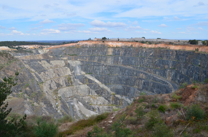


Greenbushes Mine, Greenbushes Tinfield, Bridgetown-Greenbushes Shire, Western Australia, Australia