| Locality | Latitude | Longitude | Distance | Bearing |
|---|
| Gunnison Hills, Cochise Mining District, Cochise County, Arizona, USA | 32° 1' 41" N | 110° 2' 19" W | 0.0km (0.0 miles) | |
| Dragoon, Cochise Mining District, Cochise County, Arizona, USA | 32° 1' 41" N | 110° 2' 19" W | 0.0km (0.0 miles) | |
| Dragoon Pass, Middle Pass Mining District, Cochise County, Arizona, USA | 32° 1' 39" N | 110° 2' 22" W | 0.1km (0.1 miles) | |
| Princess group, Dragoon, Cochise Mining District, Cochise County, Arizona, USA | 32° 1' 36" N | 110° 2' 59" W | 1.1km (0.7 miles) | |
| Empire Copper and Gold Mining Co. property (Unnamed Cu-Ag-W prospects), Dragoon, Cochise Mining District, Cochise County, Arizona, USA | 32° 1' 45" N | 110° 3' 2" W | 1.1km (0.7 miles) | |
| Centurion Area small mines, Centurion, Cochise Mining District, Cochise County, Arizona, USA | 32° 2' 34" N | 110° 2' 13" W | 1.6km (1.0 miles) | |
| Dragoon project, Dragoon, Cochise Mining District, Cochise County, Arizona, USA | 32° 1' 3" N | 110° 3' 4" W | 1.7km (1.0 miles) | |
| Jordan Canyon prospects, Jordan Canyon, Dragoon, Cochise Mining District, Cochise County, Arizona, USA | 32° 1' 0" N | 110° 3' 12" W | 1.9km (1.2 miles) | |
| Empire Mines, Dragoon, Cochise Mining District, Cochise County, Arizona, USA | 32° 1' 8" N | 110° 3' 21" W | 1.9km (1.2 miles) | |
| Empire No. 2 Mine (Empire No. 2 shaft), Empire Mines, Dragoon, Cochise Mining District, Cochise County, Arizona, USA | 32° 1' 5" N | 110° 3' 20" W | 1.9km (1.2 miles) | |
| Princes and Cowboy workings (Gold Coin Mine; Old Bridge shaft), Dragoon, Cochise Mining District, Cochise County, Arizona, USA | 32° 1' 5" N | 110° 3' 20" W | 1.9km (1.2 miles) | |
| Centurion prospect, Centurion, Cochise Mining District, Cochise County, Arizona, USA | 32° 2' 34" N | 110° 3' 5" W | 2.0km (1.3 miles) | |
| Unnamed Ag mine, Dragoon, Cochise Mining District, Cochise County, Arizona, USA | 32° 0' 51" N | 110° 3' 15" W | 2.1km (1.3 miles) | |
| Burrell claims, Dragoon, Cochise Mining District, Cochise County, Arizona, USA | 32° 1' 3" N | 110° 3' 30" W | 2.2km (1.4 miles) | |
| Unnamed W-Cu prospect, Dragoon, Cochise Mining District, Cochise County, Arizona, USA | 32° 2' 53" N | 110° 3' 10" W | 2.6km (1.6 miles) | |
| Unnamed W prospect [3], Dragoon, Cochise Mining District, Cochise County, Arizona, USA | 32° 2' 38" N | 110° 3' 33" W | 2.6km (1.6 miles) | |
| Burrel group of claims, Cochise Mining District, Cochise County, Arizona, USA | 32° 1' 39" N | 110° 4' 0" W | 2.7km (1.7 miles) | |
| Centurion Mine, Centurion, Cochise Mining District, Cochise County, Arizona, USA | 32° 3' 4" N | 110° 2' 49" W | 2.7km (1.7 miles) | |
| Dragoon Mountains prospect, Cochise County, Arizona, USA | 32° 0' 51" N | 110° 0' 26" W | 3.3km (2.1 miles) | |
| Green Chip Marble Quarry, Dragoon Marble Quarries (Ligier Marble Quarries; Ligier-Arizona Marble Quarries), Dragoon District(Golden Rule District), Cochise County, Arizona, USA | 32° 0' 23" N | 110° 0' 15" W | 4.0km (2.5 miles) | |
| Standard prospect, Cochise Mining District, Cochise County, Arizona, USA | 32° 3' 56" N | 110° 2' 26" W | 4.2km (2.6 miles) | |
| Burrito de Fierro Mine, Cochise Mining District, Cochise County, Arizona, USA | 31° 59' 29" N | 110° 1' 27" W | 4.3km (2.7 miles) | |
| Southern Pacific Railway Station area, Dragoon, Cochise Mining District, Cochise County, Arizona, USA | 32° 2' 8" N | 109° 59' 34" W | 4.4km (2.7 miles) | |
| Banks Mine, Cochise Mining District, Cochise County, Arizona, USA | 32° 4' 5" N | 110° 3' 6" W | 4.6km (2.9 miles) | |
| White Marble Quarries (Paul claim; Godfather claims), Dragoon Marble Quarries (Ligier Marble Quarries; Ligier-Arizona Marble Quarries), Dragoon District(Golden Rule District), Cochise County, Arizona, USA | 31° 59' 44" N | 110° 0' 19" W | 4.8km (3.0 miles) | |
| Marmobello Mine (Marmobello Quarry), Cochise Mining District, Cochise County, Arizona, USA | 32° 3' 42" N | 110° 0' 16" W | 4.9km (3.1 miles) | |
| Texas Canyon area, Dragoon, Cochise Mining District, Cochise County, Arizona, USA | 32° 3' 36" N | 110° 4' 36" W | 5.0km (3.1 miles) | |
| Ligier Marble Quarries, Dragoon District (Golden Rule District), Cochise County, Arizona, USA | 32° 1' 9" N | 109° 59' 8" W | 5.1km (3.2 miles) | |
| Stroud Brothers Mine, Gunnison Hills, Cochise Mining District, Cochise County, Arizona, USA | 32° 3' 47" N | 110° 0' 8" W | 5.2km (3.2 miles) | |
| Legal Tender prospect, Cochise Mining District, Cochise County, Arizona, USA | 32° 4' 39" N | 110° 1' 59" W | 5.5km (3.4 miles) | |
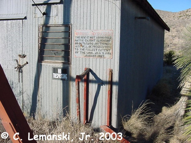

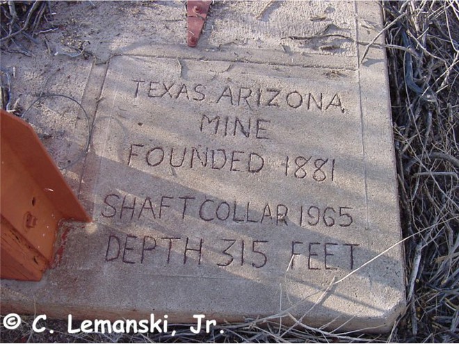


Texas Arizona Mine, Gunnison Hills, Cochise Mining District, Cochise County, Arizona, USA