| Locality | Latitude | Longitude | Distance | Bearing |
|---|
| Quarry Mountain (North Mountain), Garland County, Arkansas, USA | 34° 31' 35" N | 93° 2' 29" W | 2.1km (1.3 miles) | |
| Natural Hones Mill, Garland County, Arkansas, USA | 34° 30' 52" N | 93° 4' 35" W | 2.2km (1.4 miles) | |
| Smith Whetstone Quarry, Indian Mountain, Garland County, Arkansas, USA | 34° 32' 44" N | 92° 59' 14" W | 7.2km (4.4 miles) | |
| Indian Mountain, Garland County, Arkansas, USA | 34° 32' 47" N | 92° 59' 13" W | 7.2km (4.5 miles) | |
| Wilson Springs (Potash Sulfur Springs), Garland County, Arkansas, USA | 34° 29' 0" N | 92° 59' 0" W | 9.1km (5.7 miles) | |
| Spaulding pit, Union Carbide Mine, Wilson Springs (Potash Sulfur Springs), Garland County, Arkansas, USA | 34° 28' 50" N | 92° 58' 2" W | 10.5km (6.5 miles) | |
| North Wilson pit, Union Carbide Mine, Wilson Springs (Potash Sulfur Springs), Garland County, Arkansas, USA | 34° 28' 40" N | 92° 58' 5" W | 10.6km (6.6 miles) | |
| Union Carbide Mine, Wilson Springs (Potash Sulfur Springs), Garland County, Arkansas, USA | 34° 28' 44" N | 92° 58' 0" W | 10.6km (6.6 miles) | |
| T pit, Union Carbide Mine, Wilson Springs (Potash Sulfur Springs), Garland County, Arkansas, USA | 34° 28' 40" N | 92° 57' 47" W | 11.0km (6.8 miles) | |
| Malvern Minerals Company Mine, Garland County, Arkansas, USA | 34° 32' 55" N | 92° 56' 32" W | 11.3km (7.0 miles) | |
| East Wilson pit, Union Carbide Mine, Wilson Springs (Potash Sulfur Springs), Garland County, Arkansas, USA | 34° 28' 25" N | 92° 57' 42" W | 11.3km (7.1 miles) | |
| V intrusive, Lake Catherine, Garland County, Arkansas, USA | 34° 27' 12" N | 92° 58' 48" W | 11.6km (7.2 miles) | |
| Lecroy Farm, Garland County, Arkansas, USA | 34° 27' 57" N | 92° 55' 41" W | 14.4km (9.0 miles) | |
| Ron Coleman Mine, Blue Springs, Garland County, Arkansas, USA | 34° 39' 42" N | 93° 6' 10" W | 14.9km (9.2 miles) | |
| Shaw Mine, Blue Springs, Garland County, Arkansas, USA | 34° 39' 50" N | 93° 6' 30" W | 15.3km (9.5 miles) | |
| Dierks No. 3 Mine, Blue Springs, Garland County, Arkansas, USA | 34° 40' 20" N | 93° 3' 40" W | 15.6km (9.7 miles) | |
| Blue Springs, Garland County, Arkansas, USA | 34° 40' 22" N | 93° 4' 20" W | 15.7km (9.8 miles) | |
| Wylie Mine, Blue Springs, Garland County, Arkansas, USA | 34° 40' 24" N | 93° 5' 0" W | 15.9km (9.9 miles) | |
| McEarl Ridge prospect, Blue Springs, Garland County, Arkansas, USA | 34° 40' 18" N | 93° 6' 4" W | 16.0km (9.9 miles) | |
| McEarl Mine, Blue Springs, Garland County, Arkansas, USA | 34° 40' 28" N | 93° 5' 38" W | 16.1km (10.0 miles) | |
| Nichols & Campbell Prospect, Magnet Cove, Hot Spring County, Arkansas, USA | 34° 27' 43" N | 92° 52' 45" W | 18.6km (11.6 miles) | |
| Jessieville, Garland County, Arkansas, USA | 34° 42' 0" N | 93° 3' 45" W | 18.7km (11.6 miles) | |
| Young-Merriott Mine, Jessieville, Garland County, Arkansas, USA | 34° 42' 0" N | 93° 3' 0" W | 18.8km (11.7 miles) | |
| Kimzey Prospect, Hot Spring County, Arkansas, USA | 34° 27' 0" N | 92° 53' 0" W | 18.8km (11.7 miles) | |
| Jones Mills, Hot Spring County, Arkansas, USA | 34° 26' 19" N | 92° 53' 16" W | 19.1km (11.9 miles) | |
| Perovskite Hill, Magnet Cove, Hot Spring County, Arkansas, USA | 34° 27' 21" N | 92° 52' 33" W | 19.2km (11.9 miles) | |
| Eudialyte pegmatite, Magnet Cove, Hot Spring County, Arkansas, USA | 34° 27' 24" N | 92° 52' 31" W | 19.2km (11.9 miles) | |
| Bear (Bear City), Garland County, Arkansas, USA | 34° 32' 3" N | 93° 16' 25" W | 19.2km (12.0 miles) | |
| Cove Creek Bridge and The Branch area, Magnet Cove, Hot Spring County, Arkansas, USA | 34° 27' 23" N | 92° 52' 28" W | 19.2km (12.0 miles) | |
| Beard Mine, Blue Springs, Garland County, Arkansas, USA | 34° 39' 39" N | 93° 12' 26" W | 19.5km (12.1 miles) | |
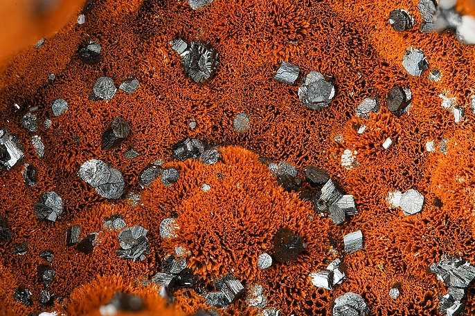

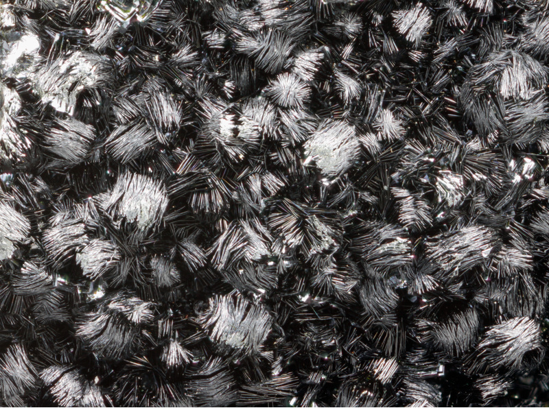


Union Carbide Mine, Wilson Springs, Garland County, Arkansas, USA