Ladjuar Medam, Sar-e-Sang, Kuran wa Munjan District, Badakhshan, Afghanistani
| Regional Level Types | |
|---|---|
| Ladjuar Medam | Deposit |
| Sar-e-Sang | Skarn |
| Kuran wa Munjan District | District |
| Badakhshan | Province |
| Afghanistan | Country |
Ladjuar Medam, Sar-e-Sang, Kokcha Valley, Badakhshan, Afghanistan
This page kindly sponsored by Rob Woodside


Latitude & Longitude (WGS84):
36° 12' 36'' North , 70° 48' 2'' East
Latitude & Longitude (decimal):
Type:
Köppen climate type:
Mindat Locality ID:
11
Long-form identifier:
mindat:1:2:11:9
GUID (UUID V4):
096c3471-d355-4c80-bc9d-44dc8d26cf22
Other/historical names associated with this locality:
Lajur Madan; Lapis-lazuli Mine; Lapis-lazuli deposit
Lapis lazuli-bearing skarn zones, up to 300 m long and 8 m thick, hosted in Archean gneiss, carbonaceous marble, calciphyre and crystalline schist that were intruded by alaskite granite and mafic dykes.
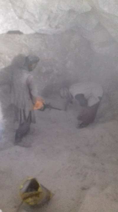
The deposit is worked by several mines which are numbered. Ladjuar Medam is a generic name that just means "Blue Mine". Thus, it may refer to any of the mines in this area.
Located in Kuran Wa Munjan District.
See article on mining lapis lazuli at Sar-e-Sang in the 1830's.
Select Mineral List Type
Standard Detailed Gallery Strunz Chemical ElementsCommodity List
This is a list of exploitable or exploited mineral commodities recorded from this region.Mineral List
Mineral list contains entries from the region specified including sub-localities37 valid minerals. 1 (TL) - type locality of valid minerals. 4 erroneous literature entries.
Rock Types Recorded
Note: data is currently VERY limited. Please bear with us while we work towards adding this information!
Rock list contains entries from the region specified including sub-localities
Select Rock List Type
Alphabetical List Tree DiagramDetailed Mineral List:
| ⓘ Aegirine Formula: NaFe3+Si2O6 References: |
| ⓘ Afghanite (TL) Formula: (Na,K)22Ca10(Si24Al24O96)(SO4)6Cl6 Localities: Habit: terminated hexagonal prisms Colour: colourless, white, blue grey, blue Fluorescence: yellow. orange in LW References: |
| ⓘ Albite Formula: Na(AlSi3O8) Localities: References: |
| ⓘ 'Andradite-Grossular Series' Localities: References: |
| ⓘ Anhydrite Formula: CaSO4 References: |
| ⓘ Formula: Ca(Al2Si2O8) References: |
| ⓘ 'Biotite' Formula: K(Fe2+/Mg)2(Al/Fe3+/Mg/Ti)([Si/Al/Fe]2Si2O10)(OH/F)2 References: |
| ⓘ Calcite Formula: CaCO3 Localities: Ladjuar Medam, Sar-e-Sang, Kuran wa Munjan District, Badakhshan, Afghanistan Unnamed Richterite occurrence, Ladjuar Medam, Sar-e-Sang, Kuran wa Munjan District, Badakhshan, Afghanistan Unnamed Nepheline occurrence, Ladjuar Medam, Sar-e-Sang, Kuran wa Munjan District, Badakhshan, Afghanistan Dar-e-Zu mine, Ladjuar Medam, Sar-e-Sang, Kuran wa Munjan District, Badakhshan, Afghanistan Unnamed Gem Sodalite occurrence, Ladjuar Medam, Sar-e-Sang, Kuran wa Munjan District, Badakhshan, Afghanistan |
| ⓘ Chlorapatite Formula: Ca5(PO4)3Cl References: |
| ⓘ Chondrodite Formula: Mg5(SiO4)2F2 References: |
| ⓘ Formula: Mg9(SiO4)4F2 Description: All the "Chondrodites" and "Clinohumites" in Clinochlore are Hydroxyclinohumite and from Jikhan, close by Ladjuar Medan. |
| ⓘ Colusite Formula: Cu13VAs3S16 Localities: Habit: Tetrahedra Colour: Bronze grey Fluorescence: none Description: Identified by Chris Stanley at the British museum.
This low Sn colusite is similar to Italian material from Carrara References: |
| ⓘ Diopside Formula: CaMgSi2O6 Localities: |
| ⓘ Dolomite Formula: CaMg(CO3)2 Localities: References: |
| ⓘ 'Fayalite-Forsterite Series' References: |
| ⓘ Fluorapatite Formula: Ca5(PO4)3F References: |
| ✪ Fluoro-richterite Formula: {Na}{CaNa}{Mg5}(Si8O22)(F,OH)2 Habit: Prismatic xls to a few cm Colour: white Fluorescence: none Description: A translucent white 'richterite' with purple hackmanite under Raman analysis gave a tiny Hydroxyl peak characteristic of Fluorine replacement making the 'richterite', fluororichterite |
| ⓘ Forsterite Formula: Mg2SiO4 |
| ⓘ 'Garnet Group' Formula: X3Z2(SiO4)3 References: |
| ⓘ Grossular Formula: Ca3Al2(SiO4)3 Colour: light red brown Fluorescence: none Description: Occurs in white calcite with pine green diopside. Analysed by John Attard References: |
| ✪ 'Hackmanite' Formula: Na8Al6Si6O24(Cl2,S) Habit: Crude to sharp dodecahedra with trapezohedral modifications Colour: clear, white, grey, green, lilac, purple Fluorescence: In Long Wave UV: yellow orange, pink, white Description: These are some of the best Hackmanites ever found and show a variety of optical properties, such as darkening in the dark after bleaching in Yellow light, Reversible Photochromism (tenebrescence)with UV irradiation and yellow light. The grey sodalites contain significant K. |
| ⓘ Haüyne Formula: Na3Ca(Si3Al3)O12(SO4) References: |
| ⓘ Hedenbergite Formula: CaFe2+Si2O6 References: |
| ⓘ Hydroxylclinohumite Formula: Mg9(SiO4)4(OH)2 |
| ⓘ 'K Feldspar' References: |
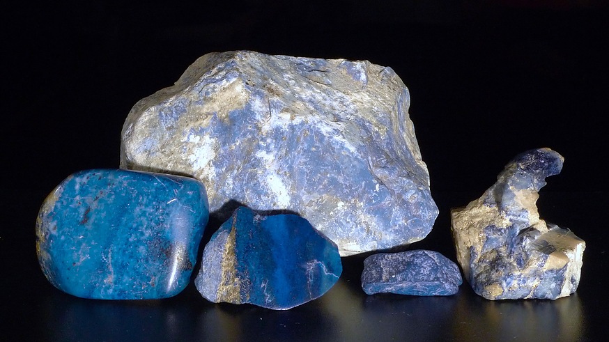
| ✪ Lazurite Formula: Na7Ca(Al6Si6O24)(SO4)(S3) · H2O Habit: Rhombic dodecahedrons modified with cube and octahedral forms Colour: Ultramarine to midnight blue Fluorescence: none, Description: Since all 'lazurites' are sulfide rich hauynes, we restrict the name Lazurite to the blue mineral in Lapis Lazuli, which is opaque, non fluorescent, ultramarine to midnight blue with a bright blue streak |
| ⓘ Magnetite Formula: Fe2+Fe3+2O4 |
| ⓘ Marialite Formula: Na4Al3Si9O24Cl Localities: Habit: Simple tetragonal prism with pyramid and pinacoid Colour: Colourless transparent Fluorescence: pale yellow Description: A 7 cm crystal frozen in calcite was found on "the back side of the mountain containing Ladjuar Medan." (Dudley Blauwet private communication) References: |
| ⓘ Molybdenite Formula: MoS2 |
| ⓘ Monticellite Formula: CaMgSiO4 |
| ⓘ Formula: KAl2(AlSi3O10)(OH)2 Description: No data. Possibly phlogopite. |
| ⓘ Nepheline Formula: Na3K(Al4Si4O16) Localities: Habit: Hexagonal prisms with small pyramids and large pinacoid Colour: grey white Fluorescence: none Description: The electric blue colour is from Nosean flecks in a clear sodalite coating the large nephelines References: |
| ⓘ Nosean Formula: Na8(Al6Si6O24)(SO4) · H2O Localities: Habit: Exsolution specs. Colour: electric blue Fluorescence: none Description: The x-rays suggest Nosean, Lazurite or Hauyne, but EDS shows the blue specs to be nosean (contains no Ca like Lazurite or Hauyne) These 0.1 micron specs are at the current limit of single xl XRD. The nosean is exsolved from a 100 micron layer of clear sodalite. This exsolution has been observed in synthetic materials (Van Peteghen et al 1963). This clear sodalite coats and is not in epitaxi with cm sized greasy grey nepheline xls. |
| ⓘ Omphacite Formula: (NaaCabFe2+cMgd)(AleFe3+fFe2+gMgh)Si2O6 References: |
| ⓘ Phlogopite Formula: KMg3(AlSi3O10)(OH)2 Localities: |
| ⓘ 'Plagioclase' Formula: (Na,Ca)[(Si,Al)AlSi2]O8 |
| ⓘ Potassic-fluoro-richterite ? Formula: {K}{CaNa}{Mg5}(Si8O22)(F,OH)2 Description: A Rob Lavisnky specimen from "Kokcha Valley". Work done on these amphoiboles indicates that they are K and F rich richterites, but generally not meeting the criteria for potassic-richterite, fluoro-richterite or ptassic-fluoro-richterite. This does not preclude the occurrence of potassic-fluoro-richterite at Sar-e Sang. References: |
| ⓘ Pyrite Formula: FeS2 Localities: Ladjuar Medam, Sar-e-Sang, Kuran wa Munjan District, Badakhshan, Afghanistan Unnamed Richterite occurrence, Ladjuar Medam, Sar-e-Sang, Kuran wa Munjan District, Badakhshan, Afghanistan Unnamed Nepheline occurrence, Ladjuar Medam, Sar-e-Sang, Kuran wa Munjan District, Badakhshan, Afghanistan Dar-e-Zu mine, Ladjuar Medam, Sar-e-Sang, Kuran wa Munjan District, Badakhshan, Afghanistan Unnamed Gem Sodalite occurrence, Ladjuar Medam, Sar-e-Sang, Kuran wa Munjan District, Badakhshan, Afghanistan |
| ⓘ Pyrrhotite Formula: Fe1-xS Description: https://www.mindat.org/mesg-609539.html
|
| ⓘ Quartz Formula: SiO2 References: |
| ⓘ Richterite Formula: Na(NaCa)Mg5(Si8O22)(OH)2 Localities: Habit: Terminated prisms Colour: colourless to yellow brown Fluorescence: none Description: Initially identified as Winchite the gemmy yellow amphibole is Potassian Fluorian Richterite ( Frank Hawthorne Analysis) |
| ⓘ 'Scapolite' References: |
| ⓘ Sodalite Formula: Na4(Si3Al3)O12Cl Localities: Unnamed Richterite occurrence, Ladjuar Medam, Sar-e-Sang, Kuran wa Munjan District, Badakhshan, Afghanistan Ladjuar Medam, Sar-e-Sang, Kuran wa Munjan District, Badakhshan, Afghanistan Unnamed Gem Sodalite occurrence, Ladjuar Medam, Sar-e-Sang, Kuran wa Munjan District, Badakhshan, Afghanistan Unnamed Nepheline occurrence, Ladjuar Medam, Sar-e-Sang, Kuran wa Munjan District, Badakhshan, Afghanistan Habit: Dodecahedra to 6 cm Colour: The colours range from colourless , to grey, to yellow, to green, to lilac, to purple. The colorless to lilac and purple are photochromic. Fluorescence: The best fluorescence is under long wave. The grey sodalite has the typical yellow disulfide fluorescence under long wave. Description: The largest and best sodalite xls to 5 cm were found here References: |
| ⓘ 'Sodalite Group' References: |
| ⓘ Spinel Formula: MgAl2O4 References: |
| ⓘ Sulphur Formula: S8 Localities: References: |
| ⓘ 'Thorianite-Uraninite Series' Formula: ThO2 - UO2 Habit: Tiny cubes but usually mm sized grains Colour: Black Fluorescence: none Description: The black dots described in Crawford (2021) were EDXed as Uraninite dominant member of this series.
( https://www.mindat.org/mesg-609539.html )
|
| ⓘ Titanite Formula: CaTi(SiO4)O References: |
| ✪ Uraninite Formula: UO2 Habit: {100} Colour: black Fluorescence: no Description: Measured hardness is 5.5
Streak is dark gray
Gamma spectra done by Adolf Cortel: https://www.mindat.org/photo-1264230.html
|
| ⓘ Formula: ◻{CaNa}{Mg4Al}(Si8O22)(OH)2 Habit: Terminated prisms Colour: Clourless to yellow brown Fluorescence: bobe Description: The Winchites are all Ricterite with some Potassium and Fluorine.
(Frank Hawthorne Analysis) |
| ⓘ Wurtzite Formula: (Zn,Fe)S Localities: Colour: orange Description: Some of these may be Rambergites as the analysed material was just shy of the 50/50 mark dividing Wurtzite and Rambergite. |
Gallery:

List of minerals arranged by Strunz 10th Edition classification
| Group 1 - Elements | |||
|---|---|---|---|
| ⓘ | Sulphur | 1.CC.05 | S8 |
| Group 2 - Sulphides and Sulfosalts | |||
| ⓘ | Colusite | 2.CB.30 | Cu13VAs3S16 |
| ⓘ | Wurtzite | 2.CB.45 | (Zn,Fe)S |
| ⓘ | Pyrrhotite | 2.CC.10 | Fe1-xS |
| ⓘ | Molybdenite | 2.EA.30 | MoS2 |
| ⓘ | Pyrite | 2.EB.05a | FeS2 |
| Group 4 - Oxides and Hydroxides | |||
| ⓘ | Spinel | 4.BB.05 | MgAl2O4 |
| ⓘ | Magnetite | 4.BB.05 | Fe2+Fe3+2O4 |
| ⓘ | Quartz | 4.DA.05 | SiO2 |
| ⓘ | Uraninite | 4.DL.05 | UO2 |
| Group 5 - Nitrates and Carbonates | |||
| ⓘ | Calcite | 5.AB.05 | CaCO3 |
| ⓘ | Dolomite | 5.AB.10 | CaMg(CO3)2 |
| Group 7 - Sulphates, Chromates, Molybdates and Tungstates | |||
| ⓘ | Anhydrite | 7.AD.30 | CaSO4 |
| Group 8 - Phosphates, Arsenates and Vanadates | |||
| ⓘ | Chlorapatite | 8.BN.05 | Ca5(PO4)3Cl |
| ⓘ | Fluorapatite | 8.BN.05 | Ca5(PO4)3F |
| Group 9 - Silicates | |||
| ⓘ | Forsterite | 9.AC.05 | Mg2SiO4 |
| ⓘ | Monticellite | 9.AC.10 | CaMgSiO4 |
| ⓘ | Grossular | 9.AD.25 | Ca3Al2(SiO4)3 |
| ⓘ | Chondrodite | 9.AF.45 | Mg5(SiO4)2F2 |
| ⓘ | Hydroxylclinohumite | 9.AF.55 | Mg9(SiO4)4(OH)2 |
| ⓘ | Clinohumite ? | 9.AF.55 | Mg9(SiO4)4F2 |
| ⓘ | Titanite | 9.AG.15 | CaTi(SiO4)O |
| ⓘ | Hedenbergite | 9.DA.15 | CaFe2+Si2O6 |
| ⓘ | Diopside | 9.DA.15 | CaMgSi2O6 |
| ⓘ | Omphacite | 9.DA.20 | (NaaCabFe2+cMgd)(AleFe3+fFe2+gMgh)Si2O6 |
| ⓘ | Aegirine | 9.DA.25 | NaFe3+Si2O6 |
| ⓘ | Winchite ? | 9.DE.20 | ◻{CaNa}{Mg4Al}(Si8O22)(OH)2 |
| ⓘ | Fluoro-richterite | 9.DE.20 | {Na}{CaNa}{Mg5}(Si8O22)(F,OH)2 |
| ⓘ | Potassic-fluoro-richterite ? | 9.DE.20 | {K}{CaNa}{Mg5}(Si8O22)(F,OH)2 |
| ⓘ | Richterite | 9.DE.20 | Na(NaCa)Mg5(Si8O22)(OH)2 |
| ⓘ | Muscovite ? | 9.EC.15 | KAl2(AlSi3O10)(OH)2 |
| ⓘ | Phlogopite | 9.EC.20 | KMg3(AlSi3O10)(OH)2 |
| ⓘ | Nepheline | 9.FA.05 | Na3K(Al4Si4O16) |
| ⓘ | Albite | 9.FA.35 | Na(AlSi3O8) |
| ⓘ | Anorthite ? | 9.FA.35 | Ca(Al2Si2O8) |
| ⓘ | Afghanite (TL) | 9.FB.05 | (Na,K)22Ca10(Si24Al24O96)(SO4)6Cl6 |
| ⓘ | Nosean | 9.FB.10 | Na8(Al6Si6O24)(SO4) · H2O |
| ⓘ | Sodalite | 9.FB.10 | Na4(Si3Al3)O12Cl |
| ⓘ | Haüyne | 9.FB.10 | Na3Ca(Si3Al3)O12(SO4) |
| ⓘ | Lazurite | 9.FB.10 | Na7Ca(Al6Si6O24)(SO4)(S3) · H2O |
| ⓘ | 'Hackmanite' | 9.FB.10 va | Na8Al6Si6O24(Cl2,S) |
| ⓘ | Marialite | 9.FB.15 | Na4Al3Si9O24Cl |
| Unclassified | |||
| ⓘ | 'Biotite' | - | K(Fe2+/Mg)2(Al/Fe3+/Mg/Ti)([Si/Al/Fe]2Si2O10)(OH/F)2 |
| ⓘ | 'Andradite-Grossular Series' | - | |
| ⓘ | 'Thorianite-Uraninite Series' | - | ThO2 - UO2 |
| ⓘ | 'Fayalite-Forsterite Series' | - | |
| ⓘ | 'Scapolite' | - | |
| ⓘ | 'Plagioclase' | - | (Na,Ca)[(Si,Al)AlSi2]O8 |
| ⓘ | 'K Feldspar' | - | |
| ⓘ | 'Garnet Group' | - | X3Z2(SiO4)3 |
| ⓘ | 'Sodalite Group' | - | |
List of minerals for each chemical element
| H | Hydrogen | |
|---|---|---|
| H | ⓘ Biotite | K(Fe2+/Mg)2(Al/Fe3+/Mg/Ti)([Si/Al/Fe]2Si2O10)(OH/F)2 |
| H | ⓘ Lazurite | Na7Ca(Al6Si6O24)(SO4)(S3) · H2O |
| H | ⓘ Muscovite | KAl2(AlSi3O10)(OH)2 |
| H | ⓘ Nosean | Na8(Al6Si6O24)(SO4) · H2O |
| H | ⓘ Phlogopite | KMg3(AlSi3O10)(OH)2 |
| H | ⓘ Richterite | Na(NaCa)Mg5(Si8O22)(OH)2 |
| H | ⓘ Winchite | ◻{CaNa}{Mg4Al}(Si8O22)(OH)2 |
| H | ⓘ Fluoro-richterite | {Na}{CaNa}{Mg5}(Si8O22)(F,OH)2 |
| H | ⓘ Potassic-fluoro-richterite | {K}{CaNa}{Mg5}(Si8O22)(F,OH)2 |
| H | ⓘ Hydroxylclinohumite | Mg9(SiO4)4(OH)2 |
| C | Carbon | |
| C | ⓘ Calcite | CaCO3 |
| C | ⓘ Dolomite | CaMg(CO3)2 |
| O | Oxygen | |
| O | ⓘ Aegirine | NaFe3+Si2O6 |
| O | ⓘ Afghanite | (Na,K)22Ca10(Si24Al24O96)(SO4)6Cl6 |
| O | ⓘ Albite | Na(AlSi3O8) |
| O | ⓘ Anhydrite | CaSO4 |
| O | ⓘ Anorthite | Ca(Al2Si2O8) |
| O | ⓘ Biotite | K(Fe2+/Mg)2(Al/Fe3+/Mg/Ti)([Si/Al/Fe]2Si2O10)(OH/F)2 |
| O | ⓘ Calcite | CaCO3 |
| O | ⓘ Chlorapatite | Ca5(PO4)3Cl |
| O | ⓘ Chondrodite | Mg5(SiO4)2F2 |
| O | ⓘ Clinohumite | Mg9(SiO4)4F2 |
| O | ⓘ Diopside | CaMgSi2O6 |
| O | ⓘ Dolomite | CaMg(CO3)2 |
| O | ⓘ Fluorapatite | Ca5(PO4)3F |
| O | ⓘ Forsterite | Mg2SiO4 |
| O | ⓘ Grossular | Ca3Al2(SiO4)3 |
| O | ⓘ Hackmanite | Na8Al6Si6O24(Cl2,S) |
| O | ⓘ Haüyne | Na3Ca(Si3Al3)O12(SO4) |
| O | ⓘ Hedenbergite | CaFe2+Si2O6 |
| O | ⓘ Lazurite | Na7Ca(Al6Si6O24)(SO4)(S3) · H2O |
| O | ⓘ Magnetite | Fe2+Fe23+O4 |
| O | ⓘ Marialite | Na4Al3Si9O24Cl |
| O | ⓘ Monticellite | CaMgSiO4 |
| O | ⓘ Muscovite | KAl2(AlSi3O10)(OH)2 |
| O | ⓘ Nepheline | Na3K(Al4Si4O16) |
| O | ⓘ Nosean | Na8(Al6Si6O24)(SO4) · H2O |
| O | ⓘ Omphacite | (NaaCabFec2+Mgd)(AleFef3+Feg2+Mgh)Si2O6 |
| O | ⓘ Phlogopite | KMg3(AlSi3O10)(OH)2 |
| O | ⓘ Quartz | SiO2 |
| O | ⓘ Richterite | Na(NaCa)Mg5(Si8O22)(OH)2 |
| O | ⓘ Sodalite | Na4(Si3Al3)O12Cl |
| O | ⓘ Spinel | MgAl2O4 |
| O | ⓘ Titanite | CaTi(SiO4)O |
| O | ⓘ Uraninite | UO2 |
| O | ⓘ Winchite | ◻{CaNa}{Mg4Al}(Si8O22)(OH)2 |
| O | ⓘ Fluoro-richterite | {Na}{CaNa}{Mg5}(Si8O22)(F,OH)2 |
| O | ⓘ Potassic-fluoro-richterite | {K}{CaNa}{Mg5}(Si8O22)(F,OH)2 |
| O | ⓘ Hydroxylclinohumite | Mg9(SiO4)4(OH)2 |
| O | ⓘ Plagioclase | (Na,Ca)[(Si,Al)AlSi2]O8 |
| O | ⓘ Garnet Group | X3Z2(SiO4)3 |
| F | Fluorine | |
| F | ⓘ Biotite | K(Fe2+/Mg)2(Al/Fe3+/Mg/Ti)([Si/Al/Fe]2Si2O10)(OH/F)2 |
| F | ⓘ Chondrodite | Mg5(SiO4)2F2 |
| F | ⓘ Clinohumite | Mg9(SiO4)4F2 |
| F | ⓘ Fluorapatite | Ca5(PO4)3F |
| F | ⓘ Fluoro-richterite | {Na}{CaNa}{Mg5}(Si8O22)(F,OH)2 |
| F | ⓘ Potassic-fluoro-richterite | {K}{CaNa}{Mg5}(Si8O22)(F,OH)2 |
| Na | Sodium | |
| Na | ⓘ Aegirine | NaFe3+Si2O6 |
| Na | ⓘ Afghanite | (Na,K)22Ca10(Si24Al24O96)(SO4)6Cl6 |
| Na | ⓘ Albite | Na(AlSi3O8) |
| Na | ⓘ Hackmanite | Na8Al6Si6O24(Cl2,S) |
| Na | ⓘ Haüyne | Na3Ca(Si3Al3)O12(SO4) |
| Na | ⓘ Lazurite | Na7Ca(Al6Si6O24)(SO4)(S3) · H2O |
| Na | ⓘ Marialite | Na4Al3Si9O24Cl |
| Na | ⓘ Nepheline | Na3K(Al4Si4O16) |
| Na | ⓘ Nosean | Na8(Al6Si6O24)(SO4) · H2O |
| Na | ⓘ Omphacite | (NaaCabFec2+Mgd)(AleFef3+Feg2+Mgh)Si2O6 |
| Na | ⓘ Richterite | Na(NaCa)Mg5(Si8O22)(OH)2 |
| Na | ⓘ Sodalite | Na4(Si3Al3)O12Cl |
| Na | ⓘ Winchite | ◻{CaNa}{Mg4Al}(Si8O22)(OH)2 |
| Na | ⓘ Fluoro-richterite | {Na}{CaNa}{Mg5}(Si8O22)(F,OH)2 |
| Na | ⓘ Potassic-fluoro-richterite | {K}{CaNa}{Mg5}(Si8O22)(F,OH)2 |
| Na | ⓘ Plagioclase | (Na,Ca)[(Si,Al)AlSi2]O8 |
| Mg | Magnesium | |
| Mg | ⓘ Biotite | K(Fe2+/Mg)2(Al/Fe3+/Mg/Ti)([Si/Al/Fe]2Si2O10)(OH/F)2 |
| Mg | ⓘ Chondrodite | Mg5(SiO4)2F2 |
| Mg | ⓘ Clinohumite | Mg9(SiO4)4F2 |
| Mg | ⓘ Diopside | CaMgSi2O6 |
| Mg | ⓘ Dolomite | CaMg(CO3)2 |
| Mg | ⓘ Forsterite | Mg2SiO4 |
| Mg | ⓘ Monticellite | CaMgSiO4 |
| Mg | ⓘ Omphacite | (NaaCabFec2+Mgd)(AleFef3+Feg2+Mgh)Si2O6 |
| Mg | ⓘ Phlogopite | KMg3(AlSi3O10)(OH)2 |
| Mg | ⓘ Richterite | Na(NaCa)Mg5(Si8O22)(OH)2 |
| Mg | ⓘ Spinel | MgAl2O4 |
| Mg | ⓘ Winchite | ◻{CaNa}{Mg4Al}(Si8O22)(OH)2 |
| Mg | ⓘ Fluoro-richterite | {Na}{CaNa}{Mg5}(Si8O22)(F,OH)2 |
| Mg | ⓘ Potassic-fluoro-richterite | {K}{CaNa}{Mg5}(Si8O22)(F,OH)2 |
| Mg | ⓘ Hydroxylclinohumite | Mg9(SiO4)4(OH)2 |
| Al | Aluminium | |
| Al | ⓘ Afghanite | (Na,K)22Ca10(Si24Al24O96)(SO4)6Cl6 |
| Al | ⓘ Albite | Na(AlSi3O8) |
| Al | ⓘ Anorthite | Ca(Al2Si2O8) |
| Al | ⓘ Biotite | K(Fe2+/Mg)2(Al/Fe3+/Mg/Ti)([Si/Al/Fe]2Si2O10)(OH/F)2 |
| Al | ⓘ Grossular | Ca3Al2(SiO4)3 |
| Al | ⓘ Hackmanite | Na8Al6Si6O24(Cl2,S) |
| Al | ⓘ Haüyne | Na3Ca(Si3Al3)O12(SO4) |
| Al | ⓘ Lazurite | Na7Ca(Al6Si6O24)(SO4)(S3) · H2O |
| Al | ⓘ Marialite | Na4Al3Si9O24Cl |
| Al | ⓘ Muscovite | KAl2(AlSi3O10)(OH)2 |
| Al | ⓘ Nepheline | Na3K(Al4Si4O16) |
| Al | ⓘ Nosean | Na8(Al6Si6O24)(SO4) · H2O |
| Al | ⓘ Omphacite | (NaaCabFec2+Mgd)(AleFef3+Feg2+Mgh)Si2O6 |
| Al | ⓘ Phlogopite | KMg3(AlSi3O10)(OH)2 |
| Al | ⓘ Sodalite | Na4(Si3Al3)O12Cl |
| Al | ⓘ Spinel | MgAl2O4 |
| Al | ⓘ Winchite | ◻{CaNa}{Mg4Al}(Si8O22)(OH)2 |
| Al | ⓘ Plagioclase | (Na,Ca)[(Si,Al)AlSi2]O8 |
| Si | Silicon | |
| Si | ⓘ Aegirine | NaFe3+Si2O6 |
| Si | ⓘ Afghanite | (Na,K)22Ca10(Si24Al24O96)(SO4)6Cl6 |
| Si | ⓘ Albite | Na(AlSi3O8) |
| Si | ⓘ Anorthite | Ca(Al2Si2O8) |
| Si | ⓘ Biotite | K(Fe2+/Mg)2(Al/Fe3+/Mg/Ti)([Si/Al/Fe]2Si2O10)(OH/F)2 |
| Si | ⓘ Chondrodite | Mg5(SiO4)2F2 |
| Si | ⓘ Clinohumite | Mg9(SiO4)4F2 |
| Si | ⓘ Diopside | CaMgSi2O6 |
| Si | ⓘ Forsterite | Mg2SiO4 |
| Si | ⓘ Grossular | Ca3Al2(SiO4)3 |
| Si | ⓘ Hackmanite | Na8Al6Si6O24(Cl2,S) |
| Si | ⓘ Haüyne | Na3Ca(Si3Al3)O12(SO4) |
| Si | ⓘ Hedenbergite | CaFe2+Si2O6 |
| Si | ⓘ Lazurite | Na7Ca(Al6Si6O24)(SO4)(S3) · H2O |
| Si | ⓘ Marialite | Na4Al3Si9O24Cl |
| Si | ⓘ Monticellite | CaMgSiO4 |
| Si | ⓘ Muscovite | KAl2(AlSi3O10)(OH)2 |
| Si | ⓘ Nepheline | Na3K(Al4Si4O16) |
| Si | ⓘ Nosean | Na8(Al6Si6O24)(SO4) · H2O |
| Si | ⓘ Omphacite | (NaaCabFec2+Mgd)(AleFef3+Feg2+Mgh)Si2O6 |
| Si | ⓘ Phlogopite | KMg3(AlSi3O10)(OH)2 |
| Si | ⓘ Quartz | SiO2 |
| Si | ⓘ Richterite | Na(NaCa)Mg5(Si8O22)(OH)2 |
| Si | ⓘ Sodalite | Na4(Si3Al3)O12Cl |
| Si | ⓘ Titanite | CaTi(SiO4)O |
| Si | ⓘ Winchite | ◻{CaNa}{Mg4Al}(Si8O22)(OH)2 |
| Si | ⓘ Fluoro-richterite | {Na}{CaNa}{Mg5}(Si8O22)(F,OH)2 |
| Si | ⓘ Potassic-fluoro-richterite | {K}{CaNa}{Mg5}(Si8O22)(F,OH)2 |
| Si | ⓘ Hydroxylclinohumite | Mg9(SiO4)4(OH)2 |
| Si | ⓘ Plagioclase | (Na,Ca)[(Si,Al)AlSi2]O8 |
| Si | ⓘ Garnet Group | X3Z2(SiO4)3 |
| P | Phosphorus | |
| P | ⓘ Chlorapatite | Ca5(PO4)3Cl |
| P | ⓘ Fluorapatite | Ca5(PO4)3F |
| S | Sulfur | |
| S | ⓘ Afghanite | (Na,K)22Ca10(Si24Al24O96)(SO4)6Cl6 |
| S | ⓘ Anhydrite | CaSO4 |
| S | ⓘ Colusite | Cu13VAs3S16 |
| S | ⓘ Hackmanite | Na8Al6Si6O24(Cl2,S) |
| S | ⓘ Haüyne | Na3Ca(Si3Al3)O12(SO4) |
| S | ⓘ Lazurite | Na7Ca(Al6Si6O24)(SO4)(S3) · H2O |
| S | ⓘ Molybdenite | MoS2 |
| S | ⓘ Nosean | Na8(Al6Si6O24)(SO4) · H2O |
| S | ⓘ Pyrite | FeS2 |
| S | ⓘ Pyrrhotite | Fe1-xS |
| S | ⓘ Sulphur | S8 |
| S | ⓘ Wurtzite | (Zn,Fe)S |
| Cl | Chlorine | |
| Cl | ⓘ Afghanite | (Na,K)22Ca10(Si24Al24O96)(SO4)6Cl6 |
| Cl | ⓘ Chlorapatite | Ca5(PO4)3Cl |
| Cl | ⓘ Hackmanite | Na8Al6Si6O24(Cl2,S) |
| Cl | ⓘ Marialite | Na4Al3Si9O24Cl |
| Cl | ⓘ Sodalite | Na4(Si3Al3)O12Cl |
| K | Potassium | |
| K | ⓘ Afghanite | (Na,K)22Ca10(Si24Al24O96)(SO4)6Cl6 |
| K | ⓘ Biotite | K(Fe2+/Mg)2(Al/Fe3+/Mg/Ti)([Si/Al/Fe]2Si2O10)(OH/F)2 |
| K | ⓘ Muscovite | KAl2(AlSi3O10)(OH)2 |
| K | ⓘ Nepheline | Na3K(Al4Si4O16) |
| K | ⓘ Phlogopite | KMg3(AlSi3O10)(OH)2 |
| K | ⓘ Potassic-fluoro-richterite | {K}{CaNa}{Mg5}(Si8O22)(F,OH)2 |
| Ca | Calcium | |
| Ca | ⓘ Afghanite | (Na,K)22Ca10(Si24Al24O96)(SO4)6Cl6 |
| Ca | ⓘ Anhydrite | CaSO4 |
| Ca | ⓘ Anorthite | Ca(Al2Si2O8) |
| Ca | ⓘ Calcite | CaCO3 |
| Ca | ⓘ Chlorapatite | Ca5(PO4)3Cl |
| Ca | ⓘ Diopside | CaMgSi2O6 |
| Ca | ⓘ Dolomite | CaMg(CO3)2 |
| Ca | ⓘ Fluorapatite | Ca5(PO4)3F |
| Ca | ⓘ Grossular | Ca3Al2(SiO4)3 |
| Ca | ⓘ Haüyne | Na3Ca(Si3Al3)O12(SO4) |
| Ca | ⓘ Hedenbergite | CaFe2+Si2O6 |
| Ca | ⓘ Lazurite | Na7Ca(Al6Si6O24)(SO4)(S3) · H2O |
| Ca | ⓘ Monticellite | CaMgSiO4 |
| Ca | ⓘ Omphacite | (NaaCabFec2+Mgd)(AleFef3+Feg2+Mgh)Si2O6 |
| Ca | ⓘ Richterite | Na(NaCa)Mg5(Si8O22)(OH)2 |
| Ca | ⓘ Titanite | CaTi(SiO4)O |
| Ca | ⓘ Winchite | ◻{CaNa}{Mg4Al}(Si8O22)(OH)2 |
| Ca | ⓘ Fluoro-richterite | {Na}{CaNa}{Mg5}(Si8O22)(F,OH)2 |
| Ca | ⓘ Potassic-fluoro-richterite | {K}{CaNa}{Mg5}(Si8O22)(F,OH)2 |
| Ca | ⓘ Plagioclase | (Na,Ca)[(Si,Al)AlSi2]O8 |
| Ti | Titanium | |
| Ti | ⓘ Biotite | K(Fe2+/Mg)2(Al/Fe3+/Mg/Ti)([Si/Al/Fe]2Si2O10)(OH/F)2 |
| Ti | ⓘ Titanite | CaTi(SiO4)O |
| V | Vanadium | |
| V | ⓘ Colusite | Cu13VAs3S16 |
| Fe | Iron | |
| Fe | ⓘ Aegirine | NaFe3+Si2O6 |
| Fe | ⓘ Biotite | K(Fe2+/Mg)2(Al/Fe3+/Mg/Ti)([Si/Al/Fe]2Si2O10)(OH/F)2 |
| Fe | ⓘ Hedenbergite | CaFe2+Si2O6 |
| Fe | ⓘ Magnetite | Fe2+Fe23+O4 |
| Fe | ⓘ Omphacite | (NaaCabFec2+Mgd)(AleFef3+Feg2+Mgh)Si2O6 |
| Fe | ⓘ Pyrite | FeS2 |
| Fe | ⓘ Pyrrhotite | Fe1-xS |
| Fe | ⓘ Wurtzite | (Zn,Fe)S |
| Cu | Copper | |
| Cu | ⓘ Colusite | Cu13VAs3S16 |
| Zn | Zinc | |
| Zn | ⓘ Wurtzite | (Zn,Fe)S |
| As | Arsenic | |
| As | ⓘ Colusite | Cu13VAs3S16 |
| Mo | Molybdenum | |
| Mo | ⓘ Molybdenite | MoS2 |
| U | Uranium | |
| U | ⓘ Uraninite | UO2 |
Localities in this Region
- Badakhshan
- Kuran wa Munjan District
- Sar-e-Sang
- Kuran wa Munjan District
Other Regions, Features and Areas containing this locality
Afghanistan
- Badakhshan
- Kokcha ValleyValley
AsiaContinent
- Hindukush Himalayan RegionGroup of Mountain Ranges
Eurasian PlateTectonic Plate
This page contains all mineral locality references listed on mindat.org. This does not claim to be a complete list. If you know of more minerals from this site, please register so you can add to our database. This locality information is for reference purposes only. You should never attempt to
visit any sites listed in mindat.org without first ensuring that you have the permission of the land and/or mineral rights holders
for access and that you are aware of all safety precautions necessary.
References


Ladjuar Medam, Sar-e-Sang, Kuran wa Munjan District, Badakhshan, Afghanistan