| Locality | Latitude | Longitude | Distance | Bearing |
|---|
| Marke Valley Mine, Upton Cross, Linkinhorne, Cornwall, England, UK | 50° 31' 10" N | 4° 25' 50" W | 0.0km (0.0 miles) | |
| Upton Cross, Linkinhorne, Cornwall, England, UK | 50° 31' 24" N | 4° 25' 35" W | 0.5km (0.3 miles) | |
| West Rosedown Mine (The Caradon), Marke Valley Mine, Upton Cross, Linkinhorne, Cornwall, England, UK | 50° 30' 58" N | 4° 26' 10" W | 0.5km (0.3 miles) | |
| East Phoenix Mine, Upton Cross, Linkinhorne, Cornwall, England, UK | 50° 31' 26" N | 4° 26' 13" W | 0.6km (0.4 miles) | |
| Dunsley Wheal Phoenix, Minions, Linkinhorne, Cornwall, England, UK | 50° 31' 7" N | 4° 26' 36" W | 0.9km (0.6 miles) | |
| Caradon Hill, St Cleer, Cornwall, England, UK | 50° 30' 39" N | 4° 26' 12" W | 1.1km (0.7 miles) | |
| Wheal Phoenix, Phoenix United Mine, Minions, Linkinhorne, Cornwall, England, UK | 50° 31' 18" N | 4° 26' 48" W | 1.2km (0.7 miles) | |
| Wheal Jenkin, Minions, Linkinhorne, Cornwall, England, UK | 50° 30' 52" N | 4° 26' 54" W | 1.4km (0.9 miles) | |
| Oakbottom Stream Works, Darley, Linkinhorne, Cornwall, England, UK | 50° 31' 53" N | 4° 26' 17" W | 1.4km (0.9 miles) | |
| Phoenix United Mine, Minions, Linkinhorne, Cornwall, England, UK | 50° 31' 26" N | 4° 27' 1" W | 1.5km (0.9 miles) | |
| Tokenbury Mine (Yolland Consols; Yeoland Consols), Glasgow Caradon Consols, Pensilva, St Ive, Cornwall, England, UK | 50° 30' 23" N | 4° 25' 48" W | 1.5km (0.9 miles) | |
| Caradon quarry, Caradon Hill, St Cleer, Cornwall, England, UK | 50° 30' 30" N | 4° 26' 34" W | 1.5km (0.9 miles) | |
| Darley, Linkinhorne, Cornwall, England, UK | 50° 32' 0" N | 4° 26' 0" W | 1.5km (1.0 miles) | |
| East Caradon Mine, Linkinhorne, Cornwall, England, UK | 50° 30' 20" N | 4° 25' 45" W | 1.6km (1.0 miles) | |
| Greenhill Mine, South Phoenix Mine, Minions, Linkinhorne, Cornwall, England, UK | 50° 31' 2" N | 4° 27' 11" W | 1.6km (1.0 miles) | |
| South Phoenix Mine, Minions, Linkinhorne, Cornwall, England, UK | 50° 31' 0" N | 4° 27' 11" W | 1.6km (1.0 miles) | |
| Glasgow Caradon Consols, Pensilva, St Ive, Cornwall, England, UK | 50° 30' 20" N | 4° 25' 17" W | 1.7km (1.0 miles) | |
| Wheal Sedley, Cargibbitt Mine (Cargibbet Mine; Caradon Vale Mine), Penharget, St Ive, Cornwall, England, UK | 50° 30' 47" N | 4° 24' 33" W | 1.7km (1.0 miles) | |
| Wheal Prosper, South Phoenix Mine, Minions, Linkinhorne, Cornwall, England, UK | 50° 30' 50" N | 4° 27' 11" W | 1.7km (1.1 miles) | |
| Minions, Linkinhorne, Cornwall, England, UK | 50° 30' 51" N | 4° 27' 13" W | 1.7km (1.1 miles) | |
| Darley Mine (North Phoenix Mine), Darley, Linkinhorne, Cornwall, England, UK | 50° 32' 4" N | 4° 26' 18" W | 1.8km (1.1 miles) | |
| Gonamena Mine, St Cleer, Cornwall, England, UK | 50° 30' 29" N | 4° 26' 56" W | 1.8km (1.1 miles) | |
| Cargibbitt Mine (Cargibbet Mine; Caradon Vale Mine), Penharget, St Ive, Cornwall, England, UK | 50° 30' 47" N | 4° 24' 23" W | 1.9km (1.2 miles) | |
| Darley Ford Quarry, Darley, Linkinhorne, Cornwall, England, UK | 50° 32' 12" N | 4° 26' 26" W | 2.0km (1.3 miles) | |
| Penharget, St Ive, Cornwall, England, UK | 50° 30' 20" N | 4° 24' 46" W | 2.0km (1.3 miles) | |
| Cheesewring Quarry, Minions, Linkinhorne, Cornwall, England, UK | 50° 31' 30" N | 4° 27' 29" W | 2.0km (1.3 miles) | |
| South Caradon Mine, Caradon Hill, St Cleer, Cornwall, England, UK | 50° 30' 8" N | 4° 26' 27" W | 2.0km (1.3 miles) | |
| Wheal Hooper (South Caradon Wheal Hooper), Caradon Hill, St Cleer, Cornwall, England, UK | 50° 30' 2" N | 4° 26' 7" W | 2.2km (1.3 miles) | |
| West Caradon Mine, Crow's Nest, St Cleer, Cornwall, England, UK | 50° 30' 18" N | 4° 27' 4" W | 2.2km (1.3 miles) | |
| Pensilva, St Ive, Cornwall, England, UK | 50° 30' 7" N | 4° 24' 49" W | 2.3km (1.4 miles) | |
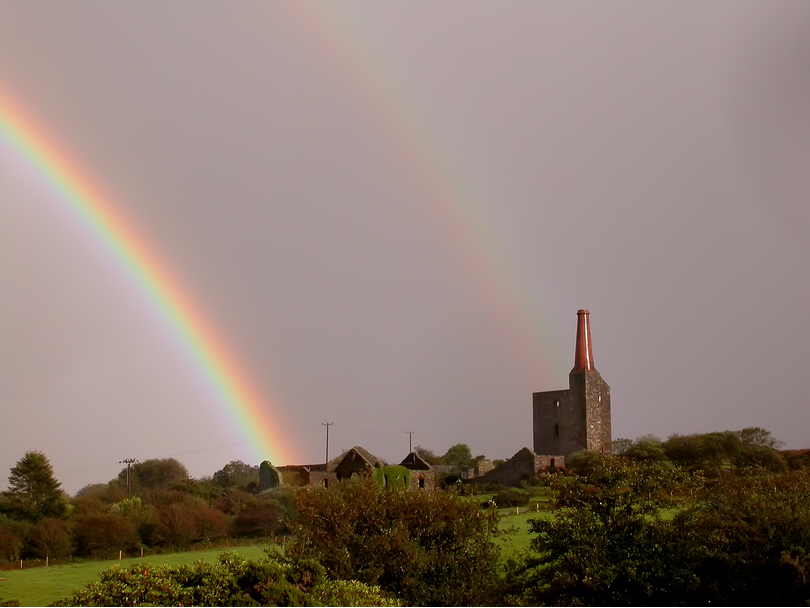
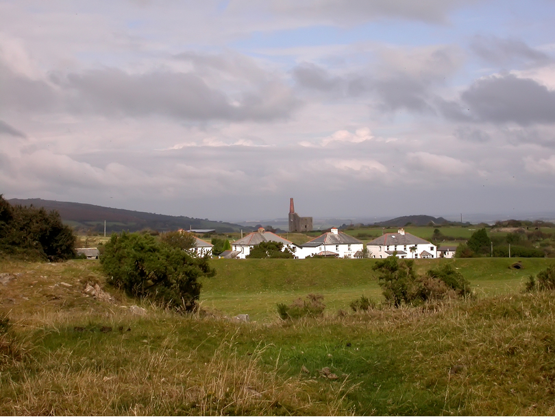


Phoenix United Mine, Minions, Linkinhorne, Cornwall, England, UK