| Locality | Latitude | Longitude | Distance | Bearing |
|---|
| Calstock Consols (Wheal Calstock; Calstock & Danescombe Consols; Danescombe Valley Mine; Tamar Consolidated Mine), Calstock, Cornwall, England, UK | 50° 30' 17" N | 4° 13' 15" W | 0.0km (0.0 miles) | |
| Cotehele Consols (Danescombe Mine), Calstock, Cornwall, England, UK | 50° 30' 10" N | 4° 13' 31" W | 0.4km (0.2 miles) | |
| Wheal Edward, Drakewalls, Calstock, Cornwall, England, UK | 50° 30' 32" N | 4° 13' 8" W | 0.5km (0.3 miles) | |
| Wheal Zion, Calstock, Cornwall, England, UK | 50° 30' 19" N | 4° 12' 46" W | 0.6km (0.4 miles) | |
| Wheal Arthur (Wheal Phoenix; Slime Veor Mine), Drakewalls, Calstock, Cornwall, England, UK | 50° 30' 33" N | 4° 12' 46" W | 0.8km (0.5 miles) | |
| Trelawney Consols (incl. Wheal Morshead), Wheal Zion, Calstock, Cornwall, England, UK | 50° 30' 7" N | 4° 12' 31" W | 0.9km (0.6 miles) | |
| Drakewalls Mine, Drakewalls, Calstock, Cornwall, England, UK | 50° 30' 51" N | 4° 13' 23" W | 1.0km (0.6 miles) | |
| North Ward Mine, Bere Alston Mines, Bere Ferrers, West Devon, Devon, England, UK | 50° 29' 43" N | 4° 13' 9" W | 1.1km (0.7 miles) | |
| Drakewalls, Calstock, Cornwall, England, UK | 50° 30' 56" N | 4° 13' 21" W | 1.2km (0.8 miles) | |
| Ward Mine (South Ward Mine), Bere Alston Mines, Bere Ferrers, West Devon, Devon, England, UK | 50° 29' 18" N | 4° 13' 12" W | 1.8km (1.1 miles) | |
| St Ann's Chapel, Calstock, Cornwall, England, UK | 50° 31' 1" N | 4° 14' 30" W | 2.0km (1.2 miles) | |
| West Drakewalls Mine, St Ann's Chapel, Calstock, Cornwall, England, UK | 50° 30' 51" N | 4° 14' 45" W | 2.0km (1.3 miles) | |
| Russell United Mine (incl. Wheal Russell), Gulworthy, West Devon, Devon, England, UK | 50° 31' 9" N | 4° 12' 8" W | 2.0km (1.3 miles) | |
| Tamar Valley Mine (New Tamar Valley Mine; Bere Alston United Mine; Wheal Fancy; Green Valley Mine; South Wheal Zion; Buttspill Mine; Old Beer Mine), Bere Alston Mines, Bere Ferrers, West Devon, Devon, England, UK | 50° 29' 22" N | 4° 12' 15" W | 2.1km (1.3 miles) | |
| Okel Tor Mine, Harewood, Calstock, Cornwall, England, UK | 50° 29' 57" N | 4° 11' 34" W | 2.1km (1.3 miles) | |
| Harewood, Calstock, Cornwall, England, UK | 50° 30' 3" N | 4° 11' 28" W | 2.2km (1.3 miles) | |
| Greenhill arsenic works, Clitters United Mines, Gunnislake, Calstock, Cornwall, England, UK | 50° 31' 23" N | 4° 13' 58" W | 2.2km (1.4 miles) | |
| Gunnislake, Calstock, Cornwall, England, UK | 50° 31' 27" N | 4° 12' 47" W | 2.2km (1.4 miles) | |
| Wheal Bazeley, St Dominick, Cornwall, England, UK | 50° 29' 11" N | 4° 13' 59" W | 2.2km (1.4 miles) | |
| Old Gunnislake Mine, Clitters United Mines, Gunnislake, Calstock, Cornwall, England, UK | 50° 31' 29" N | 4° 12' 53" W | 2.3km (1.4 miles) | |
| Gunnislake Clitters Mine, Clitters United Mines, Gunnislake, Calstock, Cornwall, England, UK | 50° 31' 32" N | 4° 13' 40" W | 2.4km (1.5 miles) | |
| South Bedford Mine (South Gunnislake Mine; in part: South Bedford and East Gunnislake Mine), Gulworthy, West Devon, Devon, England, UK | 50° 31' 29" N | 4° 12' 32" W | 2.4km (1.5 miles) | |
| Great East Tamar Mine, Bere Alston Mines, Bere Ferrers, West Devon, Devon, England, UK | 50° 29' 11" N | 4° 12' 14" W | 2.4km (1.5 miles) | |
| Harewood Consols, Harewood, Calstock, Cornwall, England, UK | 50° 30' 14" N | 4° 11' 12" W | 2.4km (1.5 miles) | |
| Wheal George, Harrowbarrow Mine (Harrowbeer Mine; Wheal Goodluck; East Wheal Brothers), Harrowbarrow & Prince of Wales Mines (Calstock United Tin and Copper Mines), Calstock, Cornwall, England, UK | 50° 30' 33" N | 4° 15' 17" W | 2.4km (1.5 miles) | |
| East Gunnislake Mine (in part: South Bedford and East Gunnislake Mine), Gunnislake, Calstock, Cornwall, England, UK | 50° 31' 33" N | 4° 12' 33" W | 2.5km (1.5 miles) | |
| Hingston Down Consols, Clitters United Mines, Gunnislake, Calstock, Cornwall, England, UK | 50° 31' 17" N | 4° 14' 45" W | 2.5km (1.6 miles) | |
| Prince of Wales Mine (Wheal Pleasant), Harrowbarrow & Prince of Wales Mines (Calstock United Tin and Copper Mines), Calstock, Cornwall, England, UK | 50° 30' 46" N | 4° 15' 24" W | 2.7km (1.7 miles) | |
| East Wheal Russell, Gulworthy, West Devon, Devon, England, UK | 50° 31' 2" N | 4° 11' 18" W | 2.7km (1.7 miles) | |
| Wheal Fortune (Wheal Newton and Queen; South Harrowbarrow Mine; incl. Wheal Newton (Wheal Barnard); Wheal Queen), Harrowbarrow Mine (Harrowbeer Mine; Wheal Goodluck; East Wheal Brothers), Harrowbarrow & Prince of Wales Mines (Calstock United Tin and Copper Mines), Calstock, Cornwall, England, UK | 50° 30' 25" N | 4° 15' 32" W | 2.7km (1.7 miles) | |

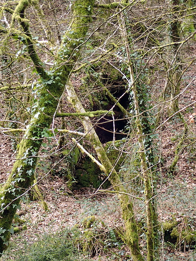

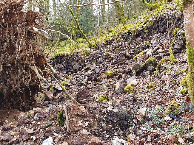


Calstock Consols, Calstock, Cornwall, England, UK