GRN grid region: N23W49
A grid 'square' of approximately 160km x 160km, part of the Global Reference Network of 19,833 grid cells covering the Earth.


Northeast Corner:
34 30'0'' N , 81 0'17'' W ( 34.5,-81.005 )
Southwest Corner:
33 0'0'' N , 82 41'30'' W ( 33,-82.6917 )
Climate:
Select Mineral List Type
Standard Detailed Gallery Strunz Chemical ElementsCommodity List
This is a list of exploitable or exploited mineral commodities recorded at this locality.Mineral List
130 valid minerals. 1 erroneous literature entry.
Rock Types Recorded
Note: data is currently VERY limited. Please bear with us while we work towards adding this information!
Select Rock List Type
Alphabetical List Tree DiagramLocalities within grid area
- Georgia
- ⭔Burke County
- ⭔Columbia County
- Elbert County
- ⭔Glascock County
- ⭔Jefferson County
- ⭔Lincoln County
- Amity
- Bohler (Mathis; Bohler Mathis)
- Bussey Property
- Chamber Mine
- Clay Hill
- Edmunds Prospect
- Fishing Creek
- Goldman Mn Mine
- Graves Mountain
- Kenna
- Lincolnton
- Little River
- Metasville
- Piedmont Belt
- Piedmont Manganese Belt (Georgia-South Carolina Piedmont Mn. Belt)
- Sales & Lamar Mine
- Samuels Place (Rhodes Taturn?)
- Savannah River
- Unnamed locality
- Woodlawn
- ⭔McDuffie County
- ⭔Richmond County
- ⭔Warren County
- Wilkes County
- South Carolina
- Abbeville County
- Antreville
- Brown Prospects (Brown Apple Prospect; Brown Cherry Prospect)
- Calais and Douglas Mine
- Calhoun Falls
- Civil War Mine
- Clenkscales Prospect
- Due West
- Lyons Mine
- Parsons Mountain Pyrophyllite prospect
- Richard B. Russell Dam Project Quarry
- Rocky River Mine
- Saluda Mine
- Scott Quarry
- Unknown Copper (MRDS - 10084431)
- Vandiver & Cooke Scott Prospects
- Aiken County
- Aiken County Mine (Mine Number 47 North; Division; Cyprus Mines Corp; Amoco Minerals; Cyprus Mines Corp.; United Sierra)
- Aiken County Mine & Mill (National Kaolin Products Company; National Kaolin Products Mine)
- Aiken County Mine Number 1
- Aiken County Mine Number 2
- Aiken County Mine Number 3 (Southern Brick Company Mine)
- Aiken County Pit East
- Aiken County Pit West
- Aiken Kaolin Mining District
- Barden Kaolin Mine
- Bell Kaolin Mine (N. L. Industries; Batesburg Pit; Bell Clay Company; Kaolin Mine)
- Brodie Kaolin Mine
- Chaingang Kaolin Mine
- Chicora Kaolin Mine (J. M. Huber Corp.; Aiken County Mines)
- China Springs Kaolin Mine
- Dixie Clay Mine North
- Dixie Clay Mine South
- Dixie Clay Mine West
- Edisto Mine (Aiken County Mines)
- Enterprise Mine
- Giant Portland Mine
- Graniteville Mine
- Hollow Creek (Holley Creek County Road Map)
- Horse Creek (Hollow Creek)
- Ideal Mine (J. M. Huber Corp.; Aiken County Mines)
- Johnson Mine
- Langley Mine (Merry Companies; Aiken County Mines)
- Laughlin Mine
- Laughlin West Mine
- McNamee & Randall Clay Mine (Aiken County Mine; Bath Mine; Dixie Clay Mines)
- Mine Number 47 South
- Morris Pit
- Murray Kaolin Mine
- Old Harrigal Kaolin Mine
- Old Toole Kaolin Mine
- Paragon Kaolin Mine
- Payne Mine
- Pepper Branch Kaolin Pit
- Permenter Mine North (J. M. Huber Corp.; Aiken County Mines)
- Permenter Mine South (J. M. Huber Corp.; Aiken County Mines)
- Piper Kaolin Pit
- Prothro Mine
- Randall Kaolin Mine
- Richardson Mine North (J. M. Huber Corp.; Aiken County Mines)
- Abbeville County
- South Carolina
- Aiken County
- Richardson Mine South (J. M. Huber Corp.; Aiken County Mines)
- Rodgers-Younce Mine
- Rodgers Kaolin Mine
- Scott Kaolin Mine
- Seigler Kaolin Mine
- Shade Kaolin Pit
- Silver Bluff Occurrence (C. C. F. Hammond Property)
- Smith Kaolin Mine
- Southeastern Kaolin Mine (Southeastern Clay Company; Kaolin Mine)
- Town Creek
- Unidentified Mine (Horse Creek Mine; MRDS - 10080088)
- Unidentified Mine (MRDS - 10080061)
- Unidentified Mine (MRDS - 10080062)
- Unidentified Mine (MRDS - 10080063)
- Unidentified Mine (MRDS - 10080064)
- Unidentified Mine (MRDS - 10080065)
- Unidentified Mine (MRDS - 10080068)
- Unidentified Mine (MRDS - 10080071)
- Unidentified Mine (MRDS - 10080075)
- Unidentified Mine (MRDS - 10080076)
- Unidentified Mine (MRDS - 10080077)
- Unidentified Mine (MRDS - 10080078)
- Unidentified Mine (MRDS - 10080087)
- Unidentified Mine (MRDS - 10080092)
- Unidentified Mine (MRDS - 10080093)
- Unidentified Mine (MRDS - 10089751)
- Unidentified Mine (MRDS - 10089755)
- Unidentified Mine (MRDS - 10089757)
- Unidentified Mine (MRDS - 10089758)
- Unidentified Mine (MRDS - 10089759)
- Unidentified Mine (MRDS - 10089762)
- Unidentified Mine (MRDS - 10089763)
- Unidentified Mine (MRDS - 10089764)
- Unidentified Mine (MRDS - 10106175)
- Unidentified Mine (MRDS - 10106177)
- Unidentified Mine (MRDS - 10106178)
- Unidentified Prospects (MRDS - 10089756)
- Unnamed Granite Quarry (MRDS - 10089947)
- Unnamed Kaolin Pit (MRDS - 10081969)
- Unnamed Kaolin Pit (MRDS - 10081970)
- Unnamed Kaolin Pit (MRDS - 10089946)
- Unnamed Kaolin Pit (MRDS - 10106322)
- Anderson County
- Bamberg County
- Calhoun County
- Edgefield County
- Boles occurrence
- Edgefield Granite Quarry
- Edgefield Shale Pit
- Faulkner Mountain Pyrophyllite prospect
- Landrum Mine
- Long Cane Road prospect
- McCormick Quarry (Carolia Quarries Inc.; Satterfield Construction Company)
- Quattlebaum Mine (Southern Gold Mine)
- Satterfield Construction Granite Quarry
- Turkey Creek (Agusta Sand and Gravel Company; Turkey Creek Mine; Turkey Creek Shale Pit; Guignard Brick Works; Merry Land & Investment Company)
- Fairfield County
- Anderson Quarry (Winnsboro Granite Corporation Quarry)
- Blair Quarry (Lone Star Industries Inc.; Cement and Construction Materials Group)
- Hobbs Quarry
- Jaynes Prospect
- Job 126 Quarry
- Johnson Quarry
- Leiper-Davis Quarry
- McKeown Pink Quarry
- McMeekin Mine
- Monticello Quarry
- Richtex Mine (Red Pit)
- Ridgeway Mine
- Rion
- Strother Quarry
- Unnamed Dimension Stone (MRDS - 10080530)
- Unnamed Dimension Stone Quarry (MRDS - 10080527)
- Unnamed Dimension Stone Quarry (MRDS - 10080531)
- Unnamed Dimension Stone Quarry (MRDS - 10089795)
- Greenwood County
- Laurens County
- Bradshaw
- Clinton Mine (Patterson Vermiculite Company; Lauren County Mines; Patterson Mine; Laurens County Mine)
- Cold Point Granite Company Quarry
- Enoree Vermiculite Mining District
- Ezell Mine
- Garlington Kiln
- Henderson Mine
- Hudging Mine
- Ivey Mine
- Joanna Quarry (Lone Star Industries Inc.)
- Kenneth Hanna Mine
- Leonard
- Maddens-Kernals
- Master's Kiln
- Mims Mine
- Mt. Olive prospect
- Raeburn Creek Prospect (Rabon Prospect)
- Raysors Kiln
- South Rabon Creek
- Triston Mine
- Verenes tract
- W. L. Patterson Mine
- Lexington County
- Adolphus Hite Kaolin Pit
- Casparis Stone Quarry
- Cayce Quarry (Ross Quarry)
- Clamp Kaolin Pit
- Columbia Pit East (Pennsylvania Glass Sand Corp.; Columbia Works)
- Congaree River
- Corley Mill Rd Pit
- Dixiana
- Harleys Mill Pond
- Hites Kaolin pit (Corley Shale pit; Lexington County Mines)
- Hoyt-Hite Kaolin Pit
- Lexington Company Clay and Shale Mines (Corley Shale Pit)
- Lexington County Mine (MRDS - 10075792)
- Lexington County Mine (MRDS - 10075793)
- Lexington County Mine (MRDS - 10075794)
- Lexington County Mines (Columbia Works; Corley Shale Pit; Hites Kaolin Pit; Guignard Brick Works)
- Lexington County Mines (Sox Kaolin Mine; Sox Pit; Richtex Corp.)
- Lexington meteorite
- Lexington Mine (Guignard Brick Works; Lexington Plant)
- Marlowe Creek
- Red Bank Creek
- Ruffs Mountain meteorite
- Twelve Mile Creek
- Unidentified Mine (MRDS - 10081964)
- Unidentified Mine (MRDS - 10081981)
- Unnamed Crushed Stone Quarry (MRDS - 10081872)
- McCormick County
- Newberry County
- Browns Quarry
- Dickert Quarry (Swede Quarry)
- Leitzey Quarry
- Lester Prospect
- Level Quarry
- Little Mountain Kyanite Occurrence
- Newberry County Mine
- Newberry Quarry (Unnamed Dimension Stone Quarry)
- Spears Quarry (Baxter Quarry)
- Topelo Mines (Tupelo Clay Mine; Newberry County Mines; Southern Brick Company)
- Unnamed Granite Quarry (MRDS - 10089778)
- Unnamed Granite Quarry (MRDS - 10089779)
- Richland County
- Branham Mine
- Broad River Mine (Richtex Corp; Richland County Mines)
- Cedar Creek Mine
- Columbia North Quarry
- Columbia Quarry (Lipscomb Quarry; Palmetto Quarry; Morris & Company)
- Columbia Quarry (Lone Star Industries Inc.)
- Crane Creek Pit
- Dreyfus Quarry (Lone Star Industries Inc.)
- Green Hole
- Harbison Mine
- Harbison Quarry (SE Div. Martin Marietta Aggregates)
- Himnant Mine (Hinnant Mine)
- Laborde Pit
- Laborde Shale Prospect
- McMeekin Shale Pit (Old Broad River Mine)
- North Columbia Quarry (SE Div. Martin Marietta Aggregates)
- Unnamed Shale Pit (MRDS - 10081878)
- Unnamed Shale Pit (MRDS - 10081879)
- Unnamed Shale Pit (MRDS - 10089919)
- Saluda County
- Abney Clay Pit
- Batesburg- Leesville
- Bauknight Shale Pit
- Clouds Creek Pluton
- Cromley Mine
- Culbreath Mine
- Hopkins Shale Pit
- Mountain Creek Prospect
- Padgette Shale Pit
- Saluda County Mine (MRDS - 10075820)
- Saluda County Mine (Southern Brick Company; Saluda Mine)
- Saluda River Mine (Southern Brick Company; Saluda Mine; Saluda County Mines)
- Whittle Quarry
- Yarborough Mine
- Aiken County


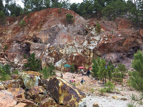
Graves Mountain, Lincoln County, Georgia, USA