Maine, USAi
| Regional Level Types | |
|---|---|
| Maine | State |
| USA | Country |
This page kindly sponsored by Maine Mineralogical and Geological Society


Neighbouring regions:
Type:
Largest Settlements:
| Place | Population |
|---|---|
| Portland | 66,881 (2018) |
| Lewiston | 36,202 (2017) |
| Bangor | 32,391 (2017) |
| West Scarborough | 27,706 (2017) |
| South Portland | 25,556 (2017) |
| South Portland Gardens | 23,893 (2017) |
Mindat Locality ID:
3772
Long-form identifier:
mindat:1:2:3772:6
GUID (UUID V4):
4d864dbd-6642-4beb-b94f-296235d79674
Other/historical names associated with this locality:
ME
Other Languages:
French:
Maine, États-Unis
German:
Maine, Vereinigte Staaten
Italian:
Maine, Stati Uniti d'America
Russian:
Мэн, Соединённые Штаты Америки
Simplified Chinese:
缅因州, 美国
Spanish:
Maine, Estados Unidos
Afrikaans:
Maine, Verenigde State van Amerika
Albanian:
Maine, Shtetet e Bashkuara të Amerikës
Amharic:
መይን, አሜሪካ
Anglo-Saxon:
Maine, Geānedu Rīcu American
Arabic:
مين, الولايات المتحدة
Aragonese:
Maine
Armenian:
Մեն, Ամերիկայի Միացյալ Նահանգներ
Asturian:
Maine, Estaos Xuníos d'América
Aymara:
Maine suyu, Istadus Unidus
Azeri:
Men, Amerika Birləşmiş Ştatları
Bashkir:
Мэн, Америка Ҡушма Штаттары
Basque:
Maine
Bavarian:
Maine, Vaoanigte Stootn
Belarusian:
Мэн, Злучаныя Штаты Амерыкі
Belarusian (Tarashkevitsa):
Мэн, Злучаныя Штаты Амэрыкі
Bengali:
মেইন, মার্কিন যুক্তরাষ্ট্র
Bishnupriya Manipuri:
মেইন, তিলপারাষ্ট্র
Bislama:
Maine, Yunaeted Stet blong Amerika
Bosnian:
Maine, Sjedinjene Američke Države
Breton:
Maine, Stadoù-Unanet Amerika
Bulgarian:
Мейн, Съединени американски щати
Burmese:
မိန်းပြည်နယ်, အမေရိကန်ပြည်ထောင်စု
Catalan:
Maine, Estats Units d’Amèrica
Cebuano:
Maine
Central Bikol:
Maine, Estados Unidos
Chechen:
Мэн, Америкин Цхьаьнатоьхна Штаташ
Chuvash:
Мэн, Пĕрлешнĕ Штатсем
Cornish:
Mayn, Statys Unys
Corsican:
Maine, Stati Uniti d'America
Croatian:
Maine, Sjedinjene Američke Države
Czech:
Maine, Spojené státy americké
Danish:
Maine, USA
Dutch:
Maine, Verenigde Staten
Egyptian Arabic:
ولاية مين, امريكا
Emilian-Romagnol:
Maine, Stat Unî
Esperanto:
Majno
Estonian:
Maine, Ameerika Ühendriigid
Faroese:
Maine
Farsi/Persian:
مین, ایالات متحده آمریکا
Fiji Hindi:
Maine, United States
Finnish:
Maine, Yhdysvallat
Franco-Provençal:
Mêne, Ètats-Unis
Gagauz:
Maine, Amerika Birleşik Devletläri
Galician:
Maine, Estados Unidos de América
Georgian:
მენის შტატი, ამერიკის შეერთებული შტატები
Greek:
Μέιν, Ηνωμένες Πολιτείες Αμερικής
Guarani:
Maine, Tetãvore Joapykuéra
Haitian:
Mèn, Etazini
Hakka:
Maine
Hausa:
Maine, Tarayyar Amurka
Hawaiian:
Maine, ‘Amelika Hui Pū ‘ia
Hebrew:
מיין, ארצות הברית
Hill Mari:
Мэн, Америкын Ушымы Штатвлӓжӹ
Hindi:
मेन, संयुक्त राज्य
Hungarian:
Maine, Amerikai Egyesült Államok
Icelandic:
Maine, Bandaríkin
Ido:
Maine, Usa
Igbo:
Mën, Njikọ̀taọ̀hà
Iloko:
Maine, Estados Unidos iti Amerika
Indonesian:
Maine, Amerika Serikat
Interlingua:
Maine, Statos Unite de America
Irish Gaelic:
Maine, Stáit Aontaithe Mheiriceá
Japanese:
メイン州, アメリカ合衆国
Javanese:
Maine, Amérika Sarékat
Judaeo-Spanish:
Maine, Estados Unidos de Amerika
Kabiye:
Meenii, Etaazuunii
Kabyle:
Maine, Iwunak Yeddukklen n Temrikt
Kalmyk:
Мэн, Америкин Ниицәтә Орн Нутугуд
Kapampangan:
Maine, Estados Unidos
Kashmiri:
مےن
Kazakh (Cyrillic Script):
Мэн, Америка Құрама Штаттары
Korean:
메인주, 미국
Kurdish (Latin Script):
Maine, Dewletên Yekbûyî yên Amerîkayê
Latin:
Cenomannica, Civitates Foederatae Americae
Latvian:
Meina, Amerikas Savienotās Valstis
Ligurian:
Maine, Stati Unïi d'America
Limburgian:
Maine, Vereinegde Staote vaan Amerika
Lithuanian:
Meinas, Jungtinės Amerikos Valstijos
Lombard:
Maine, Stat Ünì d'America
Low Saxon/Low German:
Maine, USA
Luxembourgish:
Maine, Vereenegt Staate vun Amerika
Macedonian:
Мејн, Соединети Американски Држави
Maithili:
मेन, संयुक्त राज्य अमेरिका
Malagasy:
Maine, Etazonia
Malay:
Maine, Amerika Syarikat
Malayalam:
മെയ്ൻ
Manx:
Maine, Steatyn Unnaneysit America
Maori:
Maine, Hononga-o-Amerika
Marathi:
मेन, अमेरिकेची संयुक्त संस्थाने
Mazanderani:
مین
Meadow Mari:
Мэн, Ушымо Американ Штат-влак
Min Dong Chinese:
Maine
Mingrelian:
მენიშ შტატი, ამერიკაშ აკოართაფილი შტატეფი
Mongolian:
Мэн, Америкийн Нэгдсэн Улс
Nauruan:
Maine, Eben Merika
Nepali:
मेन, संयुक्त राज्य अमेरिका
Newar / Nepal Bhasa:
मेइन, संयुक्त राज्य अमेरिका
Northern Frisian:
Maine, Feriind Stoote foon Ameerika
Northern Sami:
Maine, Amerihká ovttastuvvan stáhtat
Norwegian:
Maine, USA
Norwegian (Nynorsk):
Maine, USA
Occitan:
Maine, Estats Units d'America
Ossetian:
Мейн, Америкæйы Иугонд Штаттæ
Pali:
मेइन, संयुक्त राज्य अमेरिका
Papiamento:
Maine, Estadonan Uni di Merka
Piedmontese:
Maine, Stat Unì d'América
Polish:
Maine, Stany Zjednoczone
Portuguese:
Maine, Estados Unidos
Punjabi:
ਮੇਨ, ਸੰਯੁਕਤ ਰਾਜ ਅਮਰੀਕਾ
Quechua:
Maine suyu, Hukllachasqa Amirika Suyukuna
Romanian:
Maine, Statele Unite ale Americii
Romansh:
Maine, Stadis Unids
Russia Buriat:
Мэн
Samogitian:
Meins, JAV
Sanskrit:
मेन, अमेरिकासंयुक्तराज्यम्
Sardinian:
Maine, Istados Unidos de Amèrica
Saterland Frisian:
Maine, Fereende Stoaten fon Amerikoa
Scots:
Maine
Scottish Gaelic:
Maine, Na Stàitean Aonaichte
Serbian:
Мејн, Сједињене Америчке Државе
Serbo-Croatian:
Maine, Sjedinjene Američke Države
Sicilian:
Maine, Stati Uniti
Silesian:
Maine, Zjednoczůne Sztaty
Slovak:
Maine, Spojené štáty
Slovenian:
Maine, Združene države Amerike
South Azerbaijani:
مئین ایالتی, آمریکا بیرلشمیش ایالتلری
Swahili:
Maine, Marekani
Swedish:
Maine, USA
Tagalog:
Maine, Estados Unidos
Tamil:
மேய்ன், அமெரிக்க ஐக்கிய நாடு
Tatar:
Мэн, Америка Кушма Штатлары
Thai:
รัฐเมน, ประเทศสหรัฐอเมริกา
Traditional Chinese:
緬因州, 美國
Turkish:
Maine, Amerika Birleşik Devletleri
Ukrainian:
Мен, Сполучені Штати Америки
Upper Sorbian:
Maine, Zjednoćene staty Ameriki
Urdu:
میئن, ریاستہائے متحدہ امریکا
Uyghur:
Méané Shitati, ئامېرىكا قوشما شىتاتلىرى
Uzbek (Latin Script):
Meyn, Amerika Qoʻshma Shtatlari
Vietnamese:
Maine, Chủng Quốc Hoa Kỳ
Volapük:
Maine, Lamerikän
Waray:
Maine, Estados Unidos
Welsh:
Maine, Unol Daleithiau America
West Frisian:
Maine, Feriene Steaten
Western Punjabi:
مینے, امریکہ
Wu Chinese:
缅因, 美国
Yakut:
Мэн, Америка Холбоһуктаах Штааттара
Yiddish:
מעין, פאראייניקטע שטאטן פון אמעריקע
Yoruba:
Maine
Zazaki:
Maine, Dewletê Amerikayê Yewbiyayey
Deposits of rare-element-bearing and gem-bearing granite pegmatites are well-known in Oxford, Androscoggin, and Sagadahoc Counties in the southwest portion of the State. These pegmatites were formerly noted for ceramic-grade feldspar production along with beryl and sheet muscovite. There are many lithium- and cesium-enriched LCT pegmatites in the Oxford County and Androsoggin County Field. In Sagadahoc County, Li- or Cs-enriched LCT granite pegmatites are uncommon and there are some NYF pegmatites, present. Additional granite pegmatites occur in Cumberland County and scattered in other areas. Additional deposits include small generally low-grade lead-zinc-copper sulfide deposits along the coastal region with a few important sulfide deposits in the eastern part of the coastal region and several larger high-grade deposits in the north central part of the state ranging from Oxford, Franklin, Somerset, Piscataquis, and Aroostook Counties. Large low-grade manganese silicate deposits are present in Aroostook County. Granite quarries are widespread in the southern portion of the State including coastal regions. High grade slate is still quarried in the Monson District. Lime-grade marble is still quarried in the Thomaston District. Much of the State is composed of metamorphic and plutonic igneous rocks, with relatively few sedimentary rocks.
Maine towns and similar lands are all named. Formal local governments range from towns and cities with local jurisdiction to plantations and townships which have State oversight. Many townships have numerical and acronym abbreviations. Surveying of townships occurred sporadically and grid systems were developed as "wild land" was offered for sale. The grids are township and ranges, abbreviated "T" and "R". Due to the historical need for surveyed land, townships were re-named as needed, each survey frequently having T1 R1 as the starting point, although a few townships were named alphabetically. Usually, townships were quickly organized and residents applied for local self-government and each town received a new name. Townships that did not have sufficient population to establish a local government remained unorganized. The resulting series of surveys left many pieces of land with similar township and range designations. Suffixes were developed to distinguish these otherwise duplicating designations. One of the wealthiest men in the USA, William Bingham [March 8, 1752 – February 7, 1804], who was also an important financier of the American Revolution, invested a great deal of money in Maine lands, as did his brother-in-law, Alexander Baring. Because Bingham owned so much of Maine, about 11% at one time, the townships were coded according to their location. BPP indicated "Bingham's Penobscot Purchase", while BKP indicated "Bingham's Kennebec Purchase". Additional abbreviations, EKR and WKR, mean "East of the Kennebec River" and "West of the Kennebec River". As Bingham's lands were among the first in Maine to be surveyed into new townships, subsequent surveyors based their work on that of previous surveyors, designations such as WBKP or NBKP were used by Maine to indicate "West of Bingham's Kennebec Purchase" or "North of Bingham's Kennebec Purchase", while NBPP indicates "North of Bingham's Penobscot Purchase". Additional abbreviations include ED, MD, ND, and SD, signifying compass directions - East, North, South or "Middle" and "Division": used when there was a need to be more specific regarding a large tract of land with difficult to code townships. NWP signifies land "North of the Waldo Patent" - a piece of land owned by Revolutionary War General Samuel Waldo. A few townships remain from the Titcomb Survey and are designated TS. A few townships were grants to aid some cause, usually a school, Bowdoin College, Days Academy, etc., although canal grants were intended to help finance public works canal projects to improve commercial transportation. By far. most of the townships have the suffix WELS - "West of the Easterly Line of the State", which merely indicates the North-South surveyed border between Maine and New Brunswick.
Select Mineral List Type
Standard Detailed Gallery Strunz Chemical ElementsCommodity List
This is a list of exploitable or exploited mineral commodities recorded from this region.Mineral List
Mineral list contains entries from the region specified including sub-localities398 valid minerals. 10 (TL) - type locality of valid minerals. 2 (FRL) - first recorded locality of unapproved mineral/variety/etc. 31 erroneous literature entries.
Rock Types Recorded
Note: data is currently VERY limited. Please bear with us while we work towards adding this information!
Rock list contains entries from the region specified including sub-localities
Select Rock List Type
Alphabetical List Tree DiagramDetailed Mineral List:
| ⓘ Acanthite Formula: Ag2S Localities: Reported from at least 9 localities in this region. |
| ⓘ Actinolite Formula: ◻Ca2(Mg4.5-2.5Fe0.5-2.5)Si8O22(OH)2 Localities: Reported from at least 29 localities in this region. |
| ⓘ Aegirine Formula: NaFe3+Si2O6 Localities: Reported from at least 7 localities in this region. |
| ⓘ Aegirine-augite Formula: (NaaCabFe2+cMgd)(Fe3+eAlfFe2+gMgh)Si2O6 Localities: Reported from at least 6 localities in this region. References: |
| ⓘ Aenigmatite Formula: Na4[Fe2+10Ti2]O4[Si12O36] |
| ⓘ 'Aeschynite' |
| ⓘ Albite Formula: Na(AlSi3O8) Localities: Reported from at least 299 localities in this region. |
| ⓘ Albite var. Andesine Formula: (Na,Ca)[Al(Si,Al)Si2O8] Localities: Reported from at least 19 localities in this region. |
| ⓘ Albite var. Anorthoclase Formula: (Na,K)AlSi3O8 Localities: |
| ⓘ Albite var. Cleavelandite Formula: Na(AlSi3O8) Localities: Reported from at least 84 localities in this region. |
| ⓘ Albite var. Oligoclase Formula: (Na,Ca)[Al(Si,Al)Si2O8] Localities: Reported from at least 25 localities in this region. |
| ⓘ Albite var. Peristerite Formula: Na(AlSi3O8) Localities: References: |
| ⓘ Albite var. Zygadite Formula: Na(AlSi3O8) Localities: Reported from at least 13 localities in this region. References: |
| ⓘ Allanite-(Ce) Formula: (CaCe)(AlAlFe2+)O[Si2O7][SiO4](OH) Localities: Reported from at least 10 localities in this region. |
| ⓘ 'Allanite Group' Formula: (A12+REE3+)(M13+M23+M32+)O[Si2O7][SiO4](OH) Localities: |
| ⓘ Allophane Formula: (Al2O3)(SiO2)1.3-2 · 2.5-3H2O |
| ⓘ Alluaudite ? Formula: (Na,Ca)Mn2+(Fe3+,Mn2+,Fe2+,Mg)2(PO4)3 |
| ⓘ Almandine Formula: Fe2+3Al2(SiO4)3 Localities: Reported from at least 284 localities in this region. |
| ⓘ 'Almandine-Spessartine Series' Localities: References: |
| ⓘ Alunogen ? Formula: Al2(SO4)3 · 17H2O Description: post-mining efflorescence on pyrrhotite and not a true mineral of the locality. |
| ⓘ Amblygonite Formula: LiAl(PO4)F Localities: Reported from at least 11 localities in this region. Description: Identification confirmed by Michael Wise. |
| ⓘ Amblygonite var. Hebronite Formula: LiAl(PO4)F |
| ⓘ 'Amphibole Supergroup' Formula: AB2C5((Si,Al,Ti)8O22)(OH,F,Cl,O)2 Localities: Reported from at least 9 localities in this region. References: |
| ⓘ 'Amphibole Supergroup var. Uralite' Formula: AX2Z5((Si,Al,Ti)8O22)(OH,F,Cl,O)2 Localities: Brooksville, Blue Hill - Castine Mining District, Hancock County, Maine, USA Webster prospects (Sanford vesuvianite locality; Goodall Farm prospect; Webster vesuvianite prospect), Sanford, York County, Maine, USA Heath Quarry, Casco, Cumberland County, Maine, USA Two Hundred meter Locality, Webster prospects (Sanford vesuvianite locality; Goodall Farm prospect; Webster vesuvianite prospect), Sanford, York County, Maine, USA |
| ⓘ Analcime Formula: Na(AlSi2O6) · H2O Localities: Reported from at least 7 localities in this region. |
| ⓘ Anatase Formula: TiO2 Localities: Reported from at least 9 localities in this region. |
| ⓘ Andalusite Formula: Al2(SiO4)O Localities: Reported from at least 35 localities in this region. Habit: Square prismatic crystals with pinacoidal terminations up to 15 x 15 x 25 cm. Colour: Red-brown to pink Fluorescence: Not fluorescent Description: Found in float boulders. |
| ⓘ Andalusite var. Chiastolite Formula: Al2(SiO4)O Localities: Reported from at least 7 localities in this region. |
| ⓘ Andradite Formula: Ca3Fe3+2(SiO4)3 Localities: |
| ⓘ Anglesite Formula: PbSO4 Localities: Cape Rosier Mine (Callahan Mine; Rosier Consolidated Mine), Brooksville, Blue Hill - Castine Mining District, Hancock County, Maine, USA Lubec Lead Mine (Solomon Thayer Mine), Lubec, Washington County, Maine, USA Boston-Acton mine, Acton, York County, Maine, USA Big Hill Mine, Pembroke, Washington County, Maine, USA Porter Lead mine, Mine Pond, Porter, Oxford County, Maine, USA ? (more information) |
| ⓘ Anhydrite Formula: CaSO4 |
| ⓘ Ankerite Formula: Ca(Fe2+,Mg)(CO3)2 Localities: Reported from at least 7 localities in this region. |
| ⓘ Annite Formula: KFe2+3(AlSi3O10)(OH)2 Localities: Reported from at least 75 localities in this region. |
| ⓘ Anorthite Formula: Ca(Al2Si2O8) Localities: Reported from at least 25 localities in this region. |
| ⓘ Anorthite var. Bytownite Formula: (Ca,Na)[Al(Al,Si)Si2O8] Localities: |
| ⓘ Anorthite var. Labradorite Formula: (Ca,Na)[Al(Al,Si)Si2O8] Localities: Reported from at least 16 localities in this region. |
| ⓘ Anthophyllite Formula: ◻{Mg2}{Mg5}(Si8O22)(OH)2 Localities: Reported from at least 7 localities in this region. |
| ⓘ Antigorite Formula: Mg3(Si2O5)(OH)4 Localities: Reported from at least 8 localities in this region. |
| ⓘ Antigorite var. Bowenite Formula: Mg3(Si2O5)(OH)4 |
| ⓘ 'Apatite' Formula: Ca5(PO4)3(Cl/F/OH) Localities: Reported from at least 22 localities in this region. |
| ⓘ 'Apatite var. Carbonate-rich Apatite' |
| ⓘ 'Apatite var. Collophane' Localities: Dudley Mine (Dudley manganese prospect), Castle Hill, Aroostook County, Maine, USA Upper Maple Mountain manganese prospect, TD R2 WELS, Aroostook County, Maine, USA Hovey Mountain Manganese Prospect, T3 R9 WELS, Aroostook County, Maine, USA Lower Maple Mountain Manganese Prospect, TD R2 WELS, Aroostook County, Maine, USA |
| ⓘ ' Formula: AB4[Si8O22]X · 8H2O Locality: Loring Cove, Perry, Washington County, Maine, USA - erroneously reported |
| ⓘ Aragonite Formula: CaCO3 Localities: |
| ⓘ Arfvedsonite Formula: [Na][Na2][Fe2+4Fe3+]Si8O22(OH)2 Localities: |
| ⓘ Arsenolite Formula: As2O3 |
| ⓘ Arsenopyrite Formula: FeAsS Localities: Reported from at least 64 localities in this region. Description: Untwinned crystals to 1.5 x 0.5 cm |
| ⓘ 'Asbestos' Localities: |
| ⓘ 'Asbestos var. Mountain Leather' Localities: |
| ⓘ Astrophyllite Formula: K2NaFe2+7Ti2Si8O26(OH)4F Localities: |
| ⓘ Augelite Formula: Al2(PO4)(OH)3 Localities: |
| ⓘ Augite Formula: (CaxMgyFez)(Mgy1Fez1)Si2O6 Localities: Reported from at least 25 localities in this region. |
| ⓘ Augite var. Ferroaugite |
| ⓘ Augite var. Titanium-bearing Augite Formula: (Ca,Na)(Mg,Ti, Fe,Al,)(Si,Al)2O6 |
| ⓘ Aurichalcite Formula: (Zn,Cu)5(CO3)2(OH)6 Localities: Cape Rosier Mine (Callahan Mine; Rosier Consolidated Mine), Brooksville, Blue Hill - Castine Mining District, Hancock County, Maine, USA Lubec Lead Mine (Solomon Thayer Mine), Lubec, Washington County, Maine, USA Dolsan prospect (Barrett prospect), Pembroke, Washington County, Maine, USA Big Hill Mine, Pembroke, Washington County, Maine, USA |
| ⓘ Autunite Formula: Ca(UO2)2(PO4)2 · 10-12H2O Localities: Reported from at least 63 localities in this region. |
| ⓘ Axinite-(Fe) Formula: Ca2Fe2+Al2BSi4O15OH Localities: |
| ⓘ 'Axinite Group' Localities: |
| ⓘ Azurite Formula: Cu3(CO3)2(OH)2 Localities: Reported from at least 8 localities in this region. |
| ⓘ Babingtonite Formula: Ca2(Fe,Mn)FeSi5O14(OH) |
| ⓘ Barroisite Formula: ◻{CaNa}{Mg3Al2}(AlSi7O22)(OH)2 |
| ⓘ Baryte Formula: BaSO4 Localities: Reported from at least 9 localities in this region. |
| ⓘ 'Bastnäsite' Formula: (Ce/Nd/Y/REE)(CO3)F |
| ⓘ Bavenite Formula: Ca4Be2Al2Si9O26(OH)2 |
| ⓘ Behoite Formula: Be(OH)2 Localities: |
| ⓘ Beidellite Formula: (Na,Ca0.5)0.3Al2((Si,Al)4O10)(OH)2 · nH2O |
| ⓘ Bementite Formula: Mn7Si6O15(OH)8 |
| ⓘ Beraunite Formula: Fe3+6(PO4)4O(OH)4 · 6H2O Localities: Reported from at least 10 localities in this region. References: |
| ⓘ Berlinite Formula: AlPO4 Locality: Washington County, Maine, USA Description: Found with cassiterite in an unspecified area "near Aurora" (Sid Williams, pers. Com., 1995). Specimen was a Phelps Dodge Company mineral exploration sample (more detailed location in their closed files). |
| ⓘ Bermanite Formula: Mn2+Mn3+2(PO4)2(OH)2 · 4H2O Localities: |
| ⓘ Berthierine Formula: (Fe2+,Fe3+,Al)3(Si,Al)2O5(OH)4 |
| ⓘ Bertrandite Formula: Be4(Si2O7)(OH)2 Localities: Reported from at least 39 localities in this region. Description: One of the world's best untwinned bertrandite crystal clusters (to 4.4 x 2.5 x 2.5 cm) found about 1996 by Gregg Dionne. |
| ⓘ Beryl Formula: Be3Al2(Si6O18) Localities: Reported from at least 242 localities in this region. Description: Crystals to 11 meters long found. |
| ⓘ Beryl var. Aquamarine Formula: Be3Al2Si6O18 Localities: Reported from at least 60 localities in this region. Colour: aquamarine, blue, emerald, green Description: A very glassy beryl with the aquamarine color in slightly varying hues. |
| ⓘ Beryl var. Caesium Beryl (FRL) Formula: Be3Al2(Si6O18) Type Locality: |
| ⓘ Formula: Be3Al2(Si6O18) Locality: Topsham, Sagadahoc County, Maine, USA - erroneously reported Description: Emerald was a synonym for beryl in the 1790s when Vauquelin discovered that they were the same species. The usage of "emerald" continued in the scientific literature even until the 1830s. The cited reference merely copied out of date information. No beryl that would remotely be considered to be emerald has been found in the entire state of Maine, thus far. |
| ⓘ Beryl var. Goshenite Formula: Be3Al2(Si6O18) Localities: Reported from at least 17 localities in this region. References: |
| ⓘ Beryl var. Heliodor Formula: Be3Al2(Si6O18) Localities: Reported from at least 27 localities in this region. |
| ⓘ Beryl var. Morganite Formula: Be3Al2(Si6O18) Localities: Reported from at least 14 localities in this region. |
| ⓘ Beryllonite (TL) Formula: NaBePO4 Localities: Reported from at least 16 localities in this region. Description: Very crystallographically rich beryllonite specimens are highly prized. Most crystals from this area are usually etched and many so-called terminated crystals are actually are showing perfect cleavage. |
| ⓘ Beudantite Formula: PbFe3(AsO4)(SO4)(OH)6 Description: King and Foord, 1994, Mineralogy of Maine, v. 1 |
| ⓘ Beusite Formula: Mn2+Mn2+2 (PO4)2 |
| ⓘ Beyerite Formula: Ca(BiO)2(CO3)2 |
| ⓘ 'Biotite' Formula: K(Fe2+/Mg)2(Al/Fe3+/Mg/Ti)([Si/Al/Fe]2Si2O10)(OH/F)2 Localities: Reported from at least 221 localities in this region. |
| ⓘ 'Biotite var. Manganophyllite' ? Formula: K(Fe,Mg,Mn)3AlSi3O10(OH)2 Locality: Auburn, Androscoggin County, Maine, USA Description: Unnecessary name for relatively low Mn-bearing biotite with Fe>>Mn and which does not have a reddish brown color associated with the use of this varietal name. |
| ⓘ Birnessite Formula: (Na,Ca)0.5(Mn4+,Mn3+)2O4 · 1.5H2O Localities: |
| ⓘ Bismuth Formula: Bi Localities: Reported from at least 9 localities in this region. |
| ⓘ Bismuthinite Formula: Bi2S3 Localities: Reported from at least 8 localities in this region. Description: Crystal 45 x ~2 cm long in granite pegmatite. Specimen broken up as collectors were unaware of its significant size. |
| ⓘ Bismutite Formula: (BiO)2CO3 Localities: |
| ⓘ 'Bloodstone' Formula: SiO2 Localities: References: |
| ⓘ Bornite Formula: Cu5FeS4 Localities: Reported from at least 15 localities in this region. References: |
| ⓘ Boulangerite Formula: Pb5Sb4S11 |
| ⓘ Bournonite Formula: PbCuSbS3 |
| ⓘ Braunite Formula: Mn2+Mn3+6(SiO4)O8 Localities: Hovey Mountain Manganese Prospect, T3 R9 WELS, Aroostook County, Maine, USA Dudley Mine (Dudley manganese prospect), Castle Hill, Aroostook County, Maine, USA Upper Maple Mountain manganese prospect, TD R2 WELS, Aroostook County, Maine, USA Lower Maple Mountain Manganese Prospect, TD R2 WELS, Aroostook County, Maine, USA |
| ⓘ Brazilianite Formula: NaAl3(PO4)2(OH)4 Localities: Bell pit, Newry, Oxford County, Maine, USA Keith Quarry (Towne Quarry), West Mount Apatite Mining District, Auburn, Androscoggin County, Maine, USA Emmons Quarry, Uncle Tom Mountain, Greenwood, Oxford County, Maine, USA |
| ⓘ Brochantite Formula: Cu4(SO4)(OH)6 Localities: Cape Rosier Mine (Callahan Mine; Rosier Consolidated Mine), Brooksville, Blue Hill - Castine Mining District, Hancock County, Maine, USA Preble Hill Mine (Jones Mine), Garland, Penobscot County, Maine, USA Fisher Quarry, Topsham, Sagadahoc County, Maine, USA Lubec Lead Mine (Solomon Thayer Mine), Lubec, Washington County, Maine, USA ? (more information) |
| ⓘ Brookite Formula: TiO2 Localities: Consolidated #2 Quarry (Purington Quarry), Topsham, Sagadahoc County, Maine, USA Consolidated #1 Quarry, Topsham, Sagadahoc County, Maine, USA Route 117 road cut, North Bridgton, Bridgton, Cumberland County, Maine, USA Ryerson Hill Quarries, Paris, Oxford County, Maine, USA |
| ⓘ Calcite Formula: CaCO3 Localities: Reported from at least 97 localities in this region. |
| ⓘ Calcite var. Calcite Satin Spar Formula: CaCO3 |
| ⓘ Calcite var. Iceland Spar Formula: CaCO3 |
| ⓘ Cancrinite Formula: (Na,Ca,◻)8(Al6Si6O24)(CO3,SO4)2 · 2H2O Localities: Spears Corner Locality, West Gardiner, Kennebec County, Maine, USA Dennis Hill locality (Litchfield sodalite locality), Litchfield, Kennebec County, Maine, USA South Cochnewagon Pond locality, Monmouth, Kennebec County, Maine, USA Litchfield, Kennebec County, Maine, USA |
| ⓘ Carminite Formula: PbFe3+2(AsO4)2(OH)2 Description: King and Foord, 1994, Mineralogy of Maine, v. 1, p. 72 |
| ⓘ Formula: K2(UO2)2(VO4)2 · 3H2O Locality: Aroostook County, Maine, USA - erroneously reported |
| ⓘ Cassiterite Formula: SnO2 Localities: Reported from at least 54 localities in this region. |
| ⓘ Cerussite Formula: PbCO3 Localities: Cape Rosier Mine (Callahan Mine; Rosier Consolidated Mine), Brooksville, Blue Hill - Castine Mining District, Hancock County, Maine, USA Lubec Lead Mine (Solomon Thayer Mine), Lubec, Washington County, Maine, USA Preble Hill Mine (Jones Mine), Garland, Penobscot County, Maine, USA Big Hill Mine, Pembroke, Washington County, Maine, USA |
| ⓘ Chalcocite Formula: Cu2S Localities: Reported from at least 9 localities in this region. |
| ⓘ 'Chalcodite' Formula: K(Fe3+,Mg,Fe2+)8(Si,Al)12(O,OH)27 |
| ⓘ Formula: ZnMn4+3O7 · 3H2O Locality: Rumford, Oxford County, Maine, USA - erroneously reported |
| ⓘ Chalcophyllite Formula: Cu18Al2(AsO4)4(SO4)3(OH)24 · 36H2O |
| ⓘ Chalcopyrite Formula: CuFeS2 Localities: Reported from at least 73 localities in this region. |
| ⓘ Chamosite Formula: (Fe2+)5Al(Si,Al)4O10(OH,O)8 Localities: Reported from at least 25 localities in this region. |
| ⓘ Chamosite var. Daphnite Formula: (Fe,Mg)5Al(Si,Al)4O10(OH)8 Localities: |
| ⓘ 'Chamosite-Clinochlore Series' Localities: Reported from at least 13 localities in this region. References: |
| ⓘ Childrenite Formula: Fe2+Al(PO4)(OH)2 · H2O Localities: Reported from at least 9 localities in this region. References: |
| ⓘ Formula: AgCl Locality: Sullivan Silver mines, Sullivan Mining District, Sullivan, Hancock County, Maine, USA - erroneously reported |
| ⓘ 'Chlorite Group' Localities: Reported from at least 31 localities in this region. |
| ⓘ Chromite Formula: Fe2+Cr3+2O4 Localities: Reported from at least 6 localities in this region. |
| ⓘ Chrysoberyl Formula: BeAl2O4 Localities: Reported from at least 34 localities in this region. References: |
| ⓘ Chrysocolla Formula: Cu2-xAlx(H2-xSi2O5)(OH)4 · nH2O, x < 1 Localities: Cape Rosier Mine (Callahan Mine; Rosier Consolidated Mine), Brooksville, Blue Hill - Castine Mining District, Hancock County, Maine, USA Douglass Copper Mine, Blue Hill, Blue Hill - Castine Mining District, Hancock County, Maine, USA Tamminen Quarry, Greenwood, Oxford County, Maine, USA Ryerson Hill Quarries, Paris, Oxford County, Maine, USA Hayes Ledge Quarries (East and West), Greenwood, Oxford County, Maine, USA |
| ⓘ Chrysotile Formula: Mg3(Si2O5)(OH)4 |
| ⓘ 'Cimolite' Formula: Al4Si9O24 · 6H2O |
| ⓘ Formula: (Na,Ca,Pb)(UO2)O(OH) · 0-1H2O Localities: |
| ⓘ 'Clay minerals' |
| ⓘ Clinochlore Formula: Mg5Al(AlSi3O10)(OH)8 Localities: Reported from at least 24 localities in this region. |
| ⓘ Clinochlore var. Pennine Formula: Mg5Al(AlSi3O10)(OH)8 |
| ⓘ 'Clinochrysotile' Localities: |
| ⓘ Clino-suenoite Formula: ◻{Mn2+2}{Mg5}(Si8O22)(OH)2 Locality: Searsmont, Waldo County, Maine, USA |
| ⓘ Clinozoisite Formula: (CaCa)(AlAlAl)O[Si2O7][SiO4](OH) Localities: Reported from at least 22 localities in this region. |
| ⓘ Formula: CoAsS Locality: Kellys Cove, Northport, Waldo County, Maine, USA - erroneously reported Description: The report is based on 'thin section" observation. The confirmation of the occurrence is lacking. No data are published. Cobaltite is not the most common cobalt sulfide known and the identification is improbable.
Note: Recently the reference web page is no longer available. |
| ⓘ Collinsite Formula: Ca2Mg(PO4)2 · 2H2O |
| ⓘ Columbite-(Fe) Formula: Fe2+Nb2O6 Localities: Reported from at least 65 localities in this region. Habit: Thick platy habit. Colour: Black submetallic Fluorescence: non-fluorescent Description: Crystals well-terminated and symmetrical to 17 x 17 x ~5 cm. |
| ⓘ 'Columbite-(Fe)-Columbite-(Mn) Series' Localities: Reported from at least 18 localities in this region. |
| ⓘ 'Columbite Group' |
| ⓘ Columbite-(Mn) Formula: Mn2+Nb2O6 Localities: Reported from at least 22 localities in this region. References: |
| ⓘ 'Columbite-(Mn)-Tantalite-(Mn) Series' |
| ⓘ 'Columbite-Tantalite' Localities: |
| ⓘ Cookeite (TL) Formula: (LiAl4◻)[AlSi3O10](OH)8 Localities: Reported from at least 32 localities in this region. Type Locality: Mount Mica Quarry, Paris, Oxford County, Maine, USA Habit: Radial clusters of tightly grown platy crystals. The clusters show the typical arrangement of chlorite group minerals. Colour: White to clear when pure. Also found pale yellow, pale, green, or pale pink. References: |
| ⓘ Copiapite Formula: Fe2+Fe3+4(SO4)6(OH)2 · 20H2O |
| ⓘ Copper Formula: Cu Localities: Reported from at least 6 localities in this region. |
| ⓘ Cordierite Formula: (Mg,Fe)2Al3(AlSi5O18) Localities: Reported from at least 10 localities in this region. |
| ⓘ Correianevesite Formula: Fe2+Mn2+2(PO4)2 · 3H2O Localities: Description: Correianevesite is the unoxidized equivalent to landesite for which the Berry-Havey Quarry is the type locality. Complete chemical analysis of what is now correianevesite was made by Ian Steele of the University of Chicago in 2002 (unpublished), but a crystal structure refinement was not made to propose a new species at that time. References: |
| ⓘ Corundum Formula: Al2O3 Localities: |
| ⓘ Covellite Formula: CuS Localities: |
| ⓘ Crandallite Formula: CaAl3(PO4)(PO3OH)(OH)6 Localities: References: |
| ⓘ Cryptomelane Formula: K(Mn4+7Mn3+)O16 Localities: Reported from at least 15 localities in this region. |
| ⓘ Cubanite Formula: CuFe2S3 Localities: |
| ⓘ Cummingtonite Formula: ◻{Mg2}{Mg5}(Si8O22)(OH)2 Localities: Reported from at least 6 localities in this region. |
| ⓘ Cuprite Formula: Cu2O Localities: Reported from at least 6 localities in this region. |
| ⓘ 'Cymatolite' Localities: |
| ⓘ Darrellhenryite Formula: Na(Al2Li)Al6(Si6O18)(BO3)3(OH)3O |
| ⓘ Datolite Formula: CaB(SiO4)(OH) Localities: |
| ⓘ 'Deweylite' Formula: Mg4Si3O10 · 6H2O ? |
| ⓘ Diadochite Formula: Fe3+2(PO4)(SO4)(OH) · 6H2O Localities: Reported from at least 13 localities in this region. |
| ⓘ Diaspore Formula: AlO(OH) |
| ⓘ Dickinsonite-(KMnNa) Formula: (KNa)(Mn2+◻)Ca(Na2Na)Mn2+13Al(PO4)11(PO4)(OH)2 Localities: Reported from at least 12 localities in this region. |
| ⓘ Diopside Formula: CaMgSi2O6 Localities: Reported from at least 41 localities in this region. |
| ⓘ Diopside var. Diallage Formula: CaMgSi2O6 Locality: Deer Isle, Hancock County, Maine, USA |
| ⓘ 'Diopside-Hedenbergite Series' Localities: |
| ⓘ Dolomite Formula: CaMg(CO3)2 Localities: Reported from at least 15 localities in this region. |
| ⓘ Dravite Formula: NaMg3Al6(Si6O18)(BO3)3(OH)3(OH) Localities: Reported from at least 11 localities in this region. |
| ⓘ Dufrénite Formula: Ca0.5Fe2+Fe3+5(PO4)4(OH)6 · 2H2O Localities: |
| ⓘ Dumortierite Formula: Al(Al2O)(Al2O)2(SiO4)3(BO3) Localities: Reported from at least 24 localities in this region. |
| ⓘ Earlshannonite Formula: Mn2+Fe3+2(PO4)2(OH)2 · 4H2O Localities: |
| ⓘ Edenite Formula: NaCa2Mg5(Si7Al)O22(OH)2 |
| ⓘ Elbaite Formula: Na(Li1.5Al1.5)Al6(Si6O18)(BO3)3(OH)3(OH) Localities: Reported from at least 45 localities in this region. Habit: Prismatic crystals showing a variety of terminations: pedion, trigonal pyramidid, and occasionally a ditrigonal pyramid. Colour: Green, Red, Colorless, Blue, may be concentrically zoned in "watermelon" style or longitudinally color zoned. Fluorescence: Pink crystals sometimes fluoresce weakly to moderately in SW Description: In 1904, the world's largest elbaite crystal record was held by Mount Mica Quarry and the specimen was illustrated by Bastin (1911). References: |
| ⓘ Enargite Formula: Cu3AsS4 |
| ⓘ Enstatite Formula: Mg2Si2O6 Localities: Reported from at least 6 localities in this region. |
| ⓘ Enstatite var. Bronzite Formula: (Mg,Fe2+)2[SiO3]2 |
| ⓘ Eosphorite Formula: Mn2+Al(PO4)(OH)2 · H2O Localities: Reported from at least 27 localities in this region. Description: Former world record crystal sizes of double terminated crystals (37 mm) |
| ⓘ Epidote Formula: (CaCa)(AlAlFe3+)O[Si2O7][SiO4](OH) Localities: Reported from at least 32 localities in this region. |
| ⓘ Euclase Formula: BeAl(SiO4)(OH) Localities: References: |
| ⓘ Formula: LiAlSiO4 Locality: Spodumene Brook Prospects, Newry, Oxford County, Maine, USA - erroneously reported Description: There is no eucryptite present at this locality, either as true eucryptite or as a mixture of quartz plus albite. The spodumene from this locality does have a pale red fluorescence, but this test is inadequate to verify eucryptite. |
| ⓘ Eudialyte Formula: Na15Ca6Fe3Zr3Si(Si25O73)(O,OH,H2O)3(Cl,OH)2 |
| ⓘ Euxenite-(Y) Formula: (Y,Ca,Ce,U,Th)(Nb,Ta,Ti)2O6 Localities: References: |
| ⓘ Evansite ? Formula: Al3(PO4)(OH)6 · 6H2O Description: Reported in thin section by Sid Williams. |
| ⓘ Fairfieldite Formula: Ca2Mn2+(PO4)2 · 2H2O Localities: Reported from at least 21 localities in this region. |
| ⓘ Falsterite Formula: Ca2MgMn2+2Fe2+2Fe3+2Zn4(PO4)8(OH)4(H2O)14 |
| ⓘ Fayalite Formula: Fe2+2SiO4 Localities: Reported from at least 8 localities in this region. |
| ⓘ 'Fayalite-Forsterite Series' Localities: Reported from at least 12 localities in this region. |
| ⓘ 'Feldspar Group' Localities: Reported from at least 43 localities in this region. |
| ⓘ 'Feldspar Group var. Perthite' Localities: Reported from at least 15 localities in this region. |
| ⓘ 'Feldspar Group var. Sunstone' |
| ⓘ Ferberite Formula: FeWO4 Localities: Catherine Mountain Molybdenite prospect, Catherine Mountain, Hancock County, Maine, USA Route 176 Road cuts, Blue Hill, Blue Hill - Castine Mining District, Hancock County, Maine, USA Long Island, Blue Hill, Blue Hill - Castine Mining District, Hancock County, Maine, USA |
| ⓘ Fergusonite-(Y) Formula: YNbO4 |
| ⓘ Ferrimolybdite Formula: Fe2(MoO4)3 · nH2O Localities: Catherine Mountain Molybdenite prospect, Catherine Mountain, Hancock County, Maine, USA American Molybdenum Company Mine, Cooper, Washington County, Maine, USA Vinalhaven, Knox County, Maine, USA Long Island, Blue Hill, Blue Hill - Castine Mining District, Hancock County, Maine, USA Route 176 Road cuts, Blue Hill, Blue Hill - Castine Mining District, Hancock County, Maine, USA |
| ⓘ Ferroberaunite Formula: Fe2+Fe3+5(PO4)4(OH)5 · 6H2O Localities: Description: Beraunite was originally defined as a fully oxidized mineral, but was redefined by Fanfani and Zanazzi (1967), on the basis of a crystal structural analysis, as a mixed-valence iron phosphate and they left the original fully oxidized end-member unnamed. In essence, Fanfani and Zanazzi (1967) had discovered a new mineral species (ferroberaunite) but re-used a previous name. In the 19th century, both beraunite and eleonorite had been applied to the fully oxidized mineral. Eleonorite had been re-applied by the IMA to the oxidized end-member of the beraunite-eleonorite series. In the IMA 21-D redefinition the name beraunite was reapplied to the oxidised phase and the name ferroberaunite was created for the mixed-valence phase (Tvrdy et al., 2021 |
| ⓘ Ferro-edenite Formula: NaCa2Fe2+5(Si7Al)O22(OH)2 |
| ⓘ Ferro-hornblende Formula: ◻Ca2(Fe2+4Al)(Si7Al)O22(OH)2 Localities: |
| ⓘ Ferro-pargasite Formula: NaCa2(Fe2+4Al)(Si6Al2)O22(OH)2 |
| ⓘ Ferrorockbridgeite Formula: (Fe2+,Mn2+)2(Fe3+)3(PO4)3(OH)4(H2O) |
| ⓘ Ferrosilite Formula: Fe2+2Si2O6 Localities: |
| ⓘ Ferrostrunzite Formula: Fe2+Fe3+2(PO4)2(OH)2 · 6H2O |
| ⓘ Fersmite Formula: (Ca,Ce,Na)(Nb,Ta,Ti)2(O,OH,F)6 |
| ⓘ Fluorapatite Formula: Ca5(PO4)3F Localities: Reported from at least 135 localities in this region. |
| ⓘ Fluorapatite var. Carbonate-rich Fluorapatite Formula: Ca5(PO4,CO3)3(F,O) Localities: Reported from at least 15 localities in this region. References: |
| ⓘ Fluorapatite var. Manganapatite Formula: Ca5(PO4)3F Localities: Reported from at least 10 localities in this region. |
| ⓘ Fluorapatite var. Manganese-bearing Fluorapatite Formula: (Ca,Mn2+)5(PO4)3(F,Cl,OH) or Ca5([P,Mn5+]O4)3(F,Cl,OH) Localities: Reported from at least 6 localities in this region. |
| ⓘ Fluorcalciomicrolite Formula: (Ca,Na)2(Ta,Nb)2O6F Localities: References: Van KingIdentified by Vandall Thomas King: Dealer/Collection Label |
| ⓘ Fluor-elbaite Formula: Na(Li1.5Al1.5)Al6(Si6O18)(BO3)3(OH)3F |
| ⓘ Fluorite Formula: CaF2 Localities: Reported from at least 32 localities in this region. |
| ✪ Fluornatromicrolite Formula: (Na1.5Bi0.5)Ta2O6F |
| ⓘ Fluor-schorl Formula: NaFe2+3Al6(Si6O18)(BO3)3(OH)3F |
| ⓘ Foitite Formula: ◻(Fe2+2Al)Al6(Si6O18)(BO3)3(OH)3(OH) Localities: Reported from at least 11 localities in this region. References: |
| ⓘ Footemineite Formula: Ca2Mn2+Mn2+2Mn2+2Be4(PO4)6(OH)4 · 6H2O |
| ⓘ Forsterite Formula: Mg2SiO4 Localities: Reported from at least 11 localities in this region. |
| ⓘ Fourmarierite Formula: Pb(UO2)4O3(OH)4 · 4H2O Localities: |
| ⓘ Frondelite Formula: Mn2+Fe3+4(PO4)3(OH)5 Localities: References: |
| ⓘ Gahnite Formula: ZnAl2O4 Localities: Reported from at least 21 localities in this region. Habit: octahedral Colour: dark bluish to greenish black Description: Crystals to 15 cm known, but sharp well-formed crystals to 7 x 5 cm. |
| ⓘ Gainesite (TL) Formula: Na(Na,K)(Be,Li)Zr2(PO4)4 · 1.5-2H2O Type Locality: |
| ⓘ Galena Formula: PbS Localities: Reported from at least 91 localities in this region. |
| ⓘ Galena var. Silver-bearing Galena Formula: PbS with Ag |
| ⓘ Ganophyllite Formula: (K,Na,Ca)2Mn8(Si,Al)12(O,OH)32 · 8H2O Localities: |
| ⓘ 'Garnet Group' Formula: X3Z2(SiO4)3 Localities: Reported from at least 23 localities in this region. |
| ⓘ ' Locality: Knox Lime Company Quarry, Warren, Knox County, Maine, USA - erroneously reported |
| ⓘ Gedrite Formula: ◻{Mg2}{Mg3Al2}(Al2Si6O22)(OH)2 Localities: |
| ⓘ Formula: Ca2Al[AlSiO7] Locality: Lord Hill Quarry (Lord Hill Mine), Stoneham, Oxford County, Maine, USA - erroneously reported Description: An obviously improbable species in a granite pegmatite or its schist host rocks. Typographical error or slip of the pen for gahnite? |
| ⓘ Gersdorffite Formula: NiAsS |
| ⓘ Gibbsite Formula: Al(OH)3 |
| ⓘ Glucine Formula: CaBe4(PO4)2(OH)4 · 0.5H2O |
| ⓘ Goethite Formula: α-Fe3+O(OH) Localities: Reported from at least 73 localities in this region. References: |
| ⓘ Gold Formula: Au Localities: Reported from at least 21 localities in this region. |
| ⓘ Gorceixite Formula: BaAl3(PO4)(PO3OH)(OH)6 Localities: Description: Floater crystals to 5 mm |
| ⓘ Goyazite Formula: SrAl3(PO4)(PO3OH)(OH)6 Localities: Reported from at least 11 localities in this region. References: |
| ⓘ Graftonite Formula: Fe2+Fe2+2(PO4)2 |
| ⓘ Graphite Formula: C Localities: Reported from at least 21 localities in this region. |
| ✪ Grayite Formula: (Th,Pb,Ca)(PO4) · H2O Description: Pale yellow crystals to 1 mm with xenotime-(Y) and thorgummite. |
| ⓘ Greenockite Formula: CdS Localities: Webster prospects (Sanford vesuvianite locality; Goodall Farm prospect; Webster vesuvianite prospect), Sanford, York County, Maine, USA Bell pit, Newry, Oxford County, Maine, USA Cape Rosier Mine (Callahan Mine; Rosier Consolidated Mine), Brooksville, Blue Hill - Castine Mining District, Hancock County, Maine, USA Estes Quarry, West Baldwin, Baldwin, Cumberland County, Maine, USA Six Hundred Meter Locality, Webster prospects (Sanford vesuvianite locality; Goodall Farm prospect; Webster vesuvianite prospect), Sanford, York County, Maine, USA |
| ⓘ Greifensteinite Formula: Ca2Fe2+5Be4(PO4)6(OH)4 · 6H2O Localities: Reported from at least 8 localities in this region. |
| ⓘ Grossular Formula: Ca3Al2(SiO4)3 Localities: Reported from at least 37 localities in this region. |
| ⓘ Grossular var. Hessonite Formula: Ca3Al2(SiO4)3 Localities: Description: Found in calc-silicate contact with granite pegmatite References: |
| ⓘ Grunerite Formula: ◻{Fe2+2}{Fe2+5}(Si8O22)(OH)2 |
| ⓘ 'Gummite' Localities: Reported from at least 8 localities in this region. |
| ⓘ Gypsum Formula: CaSO4 · 2H2O Localities: Reported from at least 6 localities in this region. |
| ⓘ Hagendorfite Formula: NaCaMn2+Fe2+2(PO4)3 |
| ⓘ Halite Formula: NaCl |
| ⓘ Halloysite Formula: Al2(Si2O5)(OH)4 Localities: References: |
| ⓘ Formula: NaCa2(Fe2+4Fe3+)(Si6Al2)O22(OH)2 Localities: Description: No data have been collected to determine what species this mineral is. References: |
| ⓘ Hausmannite Formula: Mn2+Mn3+2O4 Localities: |
| ⓘ Hawleyite ? Formula: CdS |
| ⓘ Hedenbergite Formula: CaFe2+Si2O6 Localities: Description: Specifically,'Ferrohedenbergite' = Ferroan Hedenbergite |
| ⓘ Hematite Formula: Fe2O3 Localities: Reported from at least 49 localities in this region. |
| ⓘ Hematite var. Specularite Formula: Fe2O3 Localities: Reported from at least 6 localities in this region. |
| ⓘ Hemimorphite Formula: Zn4Si2O7(OH)2 · H2O Localities: |
| ⓘ Hercynite Formula: Fe2+Al2O4 Localities: |
| ⓘ Formula: (Fe,Mg)(Al,Cr)2O4 Locality: Stoneham, Oxford County, Maine, USA - erroneously reported Description: Has a question mark in reference indicating that the species is misidentified. |
| ⓘ Formula: CaBe(PO4)F Localities: Description: To date, there are only one or two verified herderite specimens in the world and that is a gemstone from Brazil. Specimens from this locality have been chemically analyzed and are true hydroxylherderite. |
| ⓘ Heterosite Formula: (Fe3+,Mn3+)PO4 Localities: Reported from at least 28 localities in this region. Description: Moore (2000) analyzed triphylite from this locality and found the Mn/Mn + Fe ratio was 0.47 References: |
| ⓘ 'Heterosite-Purpurite Series' |
| ⓘ ' Formula: (Na/Ca/K)5-6[Al8-9 Si27-28 O72] · nH2O Locality: Noyes Mountain Quarry (Harvard Quarry), Greenwood, Oxford County, Maine, USA - erroneously reported Description: A bad guess of what the original material was in the quartz pseudomorphs known for this locality. No original material ever found and probably replacements of feldspar crystals. |
| ⓘ Hisingerite Formula: Fe3+2(Si2O5)(OH)4 · 2H2O Localities: |
| ⓘ Holmquistite Formula: ◻{Li2}{Mg3Al2}(Si8O22)(OH)2 |
| ⓘ 'Hornblende Root Name Group' Formula: ◻Ca2(Z2+4Z3+)(AlSi7O22)(OH,F,Cl)2 Localities: Reported from at least 28 localities in this region. |
| ⓘ Formula: MnWO4 Locality: Douglass Copper Mine, Blue Hill, Blue Hill - Castine Mining District, Hancock County, Maine, USA - erroneously reported |
| ⓘ Humite Formula: Mg7(SiO4)3F2 Description: brownish pink grains to several mm in calc-silicate rock. |
| ⓘ Hureaulite Formula: Mn2+5(PO3OH)2(PO4)2 · 4H2O Localities: Reported from at least 10 localities in this region. References: |
| ⓘ Hurlbutite Formula: CaBe2(PO4)2 |
| ⓘ 'Hydronephelite' (FRL) Type Locality: Description: Dennis Hill is the type locality for this mineral, but it has been shown to be a mixture of gibbsite, natrolite, and diaspore. Hydronephelite was once called "white sodalite" as it formed a rim on normal blue sodalite. It is also fluorescent in Shortwave UV. |
| ⓘ Hydroxycalciomicrolite Formula: Ca1.5Ta2O6(OH) |
| ⓘ Hydroxylapatite Formula: Ca5(PO4)3(OH) Localities: Reported from at least 20 localities in this region. References: |
| ⓘ Hydroxylapatite var. Carbonate-rich Hydroxylapatite Formula: Ca5(PO4,CO3)3(OH,O) Localities: Reported from at least 8 localities in this region. |
| ⓘ Hydroxylherderite Formula: CaBe(PO4)(OH) Localities: Reported from at least 33 localities in this region. |
| ⓘ Hydrozincite Formula: Zn5(CO3)2(OH)6 |
| ⓘ 'Hypersthene' Formula: (Mg,Fe)SiO3 Localities: |
| ⓘ Ice Formula: H2O Localities: References: |
| ⓘ 'Iddingsite' Formula: MgO · Fe2O3 · 3SiO2 · 4H2O |
| ⓘ Ilmenite Formula: Fe2+TiO3 Localities: Reported from at least 20 localities in this region. |
| ⓘ 'Ilmenite Group' |
| ⓘ 'Indicolite' Formula: A(D3)G6(T6O18)(BO3)3X3Z Localities: Reported from at least 18 localities in this region. Habit: Terminated rod-like dark blue gemmy crystals to 9 cm. Colour: dark sapphire blue Fluorescence: none Description: The North American record size flawless indicolite gemstone is cut from a specimen from this quarry and is 35.17 carats. The former record was held by a light blue 23.67 carat indicolite from BB#7 Quarry, Norway, Maine. |
| ⓘ Ishikawaite Formula: U4+Fe2+Nb2O8 Localities: Reported from at least 7 localities in this region. |
| ⓘ Jahnsite-(CaMnFe) Formula: {Ca}{Mn2+}{Fe2+2}{Fe3+2}(PO4)4(OH)2 · 8H2O Localities: |
| ⓘ Jahnsite-(CaMnMn) Formula: {Ca}{Mn2+}{Mn2+2}{Fe3+2}(PO4)4(OH)2 · 8H2O Localities: References: |
| ⓘ 'Jahnsite Group' Formula: XM1M22M32(H2O)8(OH)2(PO4)4 Localities: Reported from at least 6 localities in this region. |
| ⓘ Jahnsite-(MnMnMn) Formula: {Mn2+}{Mn2+}{Mn2+2}{Fe3+2}(PO4)4(OH)2 · 8H2O |
| ⓘ Jarosite Formula: KFe3+3(SO4)2(OH)6 Localities: References: |
| ⓘ 'Jasper' Localities: Reported from at least 9 localities in this region. |
| ⓘ Kaersutite Formula: NaCa2(Mg3AlTi4+)(Si6Al2)O22O2 Localities: |
| ⓘ Kainosite-(Y) Formula: Ca2(Y,Ce)2(Si4O12)(CO3) · H2O |
| ⓘ Kamphaugite-(Y) Formula: Ca(Y,REE)(CO3)2(OH) · H2O |
| ⓘ Kaolinite Formula: Al2(Si2O5)(OH)4 Localities: Reported from at least 23 localities in this region. Description: XRD verified by Gene Foord. References: |
| ⓘ Kapundaite Formula: NaCaFe4(PO4)4(OH)3 · 5H2O |
| ⓘ Kasolite Formula: Pb(UO2)(SiO4) · H2O |
| ⓘ Kastningite Formula: (Mn2+,Fe2+,Mg)Al2(PO4)2(OH)2 · 8H2O Localities: Habit: very small colorless clusters on siderite Colour: colorless Description: Identified on five small pieces obtained from a giveaway table at a mineral conference. Probably is more common. Xls dessicate in warm light which is a property exhibited by kastningite from Foote Mine and from Silbergrube in Germany. This property is distinct for the species. Collectors should check their material for xl sprays that look like colorless stewartite. |
| ⓘ 'Kerolite' Formula: (Mg,Ni)3Si4O10(OH)2 · nH2O (n ~ 1) Localities: |
| ⓘ 'K Feldspar' Localities: Reported from at least 7 localities in this region. |
| ⓘ 'K Feldspar var. Adularia' Formula: KAlSi3O8 |
| ⓘ Kidwellite Formula: NaFe3+9+x(PO4)6(OH)11 · 3H2O, x = 0.33 |
| ⓘ Kosnarite (TL) Formula: KZr2(PO4)3 Localities: Type Locality: Mount Mica Quarry, Paris, Oxford County, Maine, USA Habit: Rhombohedral pale blue crystals which may have a a tiny c pinacoid. Colour: Pale blue |
| ⓘ Kryzhanovskite Formula: (Fe3+,Mn2+)3(PO4)2(OH,H2O)3 Localities: |
| ⓘ Kyanite Formula: Al2(SiO4)O Localities: Reported from at least 9 localities in this region. |
| ⓘ Lacroixite Formula: NaAl(PO4)F |
| ⓘ Landesite (TL) Formula: Mn2+3-xFe3+x(PO4)2(OH)x · (3-x)H2O Localities: Reported from at least 6 localities in this region. |
| ⓘ Laueite Formula: Mn2+Fe3+2(PO4)2(OH)2 · 8H2O Localities: Reported from at least 13 localities in this region. References: |
| ⓘ Laumontite Formula: CaAl2Si4O12 · 4H2O Localities: Cape Rosier Mine (Callahan Mine; Rosier Consolidated Mine), Brooksville, Blue Hill - Castine Mining District, Hancock County, Maine, USA Phippsburg, Sagadahoc County, Maine, USA Calais, Washington County, Maine, USA New England Stone Industries Quarry (Goss Quarry), Crotch Island, Stonington, Hancock County, Maine, USA |
| ⓘ Lazulite Formula: MgAl2(PO4)2(OH)2 Locality: Phippsburg, Sagadahoc County, Maine, USA |
| ⓘ Lepidocrocite Formula: γ-Fe3+O(OH) Localities: |
| ⓘ 'Lepidolite' Localities: Reported from at least 36 localities in this region. Habit: Doubly terminated platy lepidolite crystals; also "ball lepidolite" Colour: Pink through purple. References: |
| ⓘ Formula: K(AlSi2O6) Locality: Litchfield, Kennebec County, Maine, USA - erroneously reported |
| ⓘ Leucophosphite Formula: KFe3+2(PO4)2(OH) · 2H2O |
| ⓘ 'Leucoxene' Localities: Reported from at least 6 localities in this region. |
| ⓘ 'Limonite' Localities: Reported from at least 23 localities in this region. |
| ⓘ Linarite Formula: PbCu(SO4)(OH)2 Localities: Cape Rosier Mine (Callahan Mine; Rosier Consolidated Mine), Brooksville, Blue Hill - Castine Mining District, Hancock County, Maine, USA Lubec Lead Mine (Solomon Thayer Mine), Lubec, Washington County, Maine, USA Preble Hill Mine (Jones Mine), Garland, Penobscot County, Maine, USA Kendall Head, Eastport, Washington County, Maine, USA |
| ⓘ Linnaeite Formula: Co2+Co3+2S4 Localities: References: |
| ⓘ 'Lithian Muscovite' Formula: KAl2(AlSi3O10)(OH)2 |
| ⓘ Lithiophilite Formula: LiMn2+PO4 Localities: Reported from at least 17 localities in this region. Description: Moore (2000) analyzed lithiophilite from this locality and found the Mn/Mn + Fe ratio was 0.74 References: |
| ⓘ Lithiophilite var. Sicklerite Formula: Li1-x(Mn3+xMn2+1-x)PO4 Localities: References: |
| ⓘ Lithiophorite Formula: (Al,Li)MnO2(OH)2 |
| ⓘ Lithiowodginite Formula: LiTa3O8 |
| ⓘ Lizardite Formula: Mg3(Si2O5)(OH)4 Localities: References: |
| ⓘ Löllingite Formula: FeAs2 Localities: Reported from at least 15 localities in this region. Colour: silver, dull, metallic Fluorescence: non fluorescent Description: Many pieces where collected from a one foot by 6 inch area after a blast. Confirmed by Maine Mineral Museum Laboratory and Al Falser. |
| ⓘ Loparite-(Ce) Formula: (Na,REE)2Ti2O6 |
| ⓘ Ludlamite Formula: Fe2+3(PO4)2 · 4H2O Localities: Reported from at least 7 localities in this region. |
| ⓘ Lueshite Formula: NaNbO3 |
| ⓘ Mackinawite Formula: FeS Localities: |
| ⓘ Formula: MgCr2O4 Locality: Stoneham, Oxford County, Maine, USA - erroneously reported Description: Has a question mark in the reference indicating the species is misidentified. |
| ⓘ Magnesio-hornblende Formula: ◻Ca2(Mg4Al)(Si7Al)O22(OH)2 Localities: |
| ⓘ Magnesite Formula: MgCO3 Localities: Reported from at least 6 localities in this region. |
| ⓘ Magnetite Formula: Fe2+Fe3+2O4 Localities: Reported from at least 81 localities in this region. |
| ⓘ Malachite Formula: Cu2(CO3)(OH)2 Localities: Reported from at least 17 localities in this region. |
| ⓘ 'Manganese Oxides' Localities: Reported from at least 18 localities in this region. References: |
| ⓘ 'Manganese Oxides var. Manganese Dendrites' Localities: Reported from at least 11 localities in this region. |
| ⓘ Mangangordonite (TL) Formula: Mn2+Al2(PO4)2(OH)2 · 8H2O Type Locality: |
| ⓘ Formula: Mn3+O(OH) Localities: Description: Misidentified black amorphous to XRD manganese oxide stains. |
| ⓘ Marcasite Formula: FeS2 Localities: Reported from at least 10 localities in this region. |
| ⓘ Margarite Formula: CaAl2(Al2Si2O10)(OH)2 Localities: |
| ⓘ Marialite Formula: Na4Al3Si9O24Cl Localities: |
| ✪ Mccrillisite (TL) Formula: NaCs(Be,Li)Zr2(PO4)4 · 1-2H2O Type Locality: Habit: Simple steeply pyramidal crystals. Colour: White |
| ⓘ Meionite Formula: Ca4Al6Si6O24CO3 Localities: Reported from at least 16 localities in this region. |
| ⓘ Melanterite Formula: Fe2+(H2O)6SO4 · H2O Localities: Reported from at least 6 localities in this region. |
| ⓘ Messelite Formula: Ca2Fe2+(PO4)2 · 2H2O Localities: |
| ⓘ Meta-autunite Formula: Ca(UO2)2(PO4)2 · 6H2O Localities: Reported from at least 50 localities in this region. References: |
| ⓘ Metanatroautunite Formula: Na(UO2)(PO4)(H2O)3 |
| ⓘ Metaschoepite Formula: (UO2)8O2(OH)12 · 10H2O |
| ⓘ Metastibnite Formula: Sb2S3 |
| ⓘ Metaswitzerite Formula: Mn2+3(PO4)2 · 4H2O Localities: |
| ⓘ Metatorbernite Formula: Cu(UO2)2(PO4)2 · 8H2O Localities: Reported from at least 21 localities in this region. |
| ⓘ Metauranospinite Formula: Ca(UO2)2(AsO4)2 · 8H2O Description: Yellow platy masses on loellingite. Formerly call Unknown #9 |
| ⓘ Metavanmeersscheite Formula: U6+(UO2)3(PO4)2(OH)6 · 2H2O |
| ⓘ 'Mica Group' Localities: Reported from at least 10 localities in this region. |
| ⓘ 'Mica Group var. Lepidomelane' |
| ⓘ Microcline Formula: K(AlSi3O8) Localities: Reported from at least 434 localities in this region. Description: Giant well-formed crystals to over 1 x 1 meter. |
| ⓘ Microcline var. Amazonite Formula: K(AlSi3O8) Localities: |
| ⓘ 'Microlite Group' Formula: A2-mTa2X6-wZ-n Localities: Reported from at least 16 localities in this region. References: |
| ⓘ Milarite Formula: K(◻H2O)Ca2(Be2Al)[Si12O30] |
| ⓘ Mimetite Formula: Pb5(AsO4)3Cl Description: Mineralogy of Maine (King and Foord), volume 1, pages 236-237. |
| ⓘ Mitridatite Formula: Ca2Fe3+3(PO4)3O2 · 3H2O Localities: Reported from at least 14 localities in this region. References: |
| ⓘ Molybdenite Formula: MoS2 Localities: Reported from at least 35 localities in this region. |
| ⓘ Molybdite Formula: MoO3 Localities: References: |
| ⓘ 'Monazite' Formula: REE(PO4) Localities: |
| ⓘ Monazite-(Ce) Formula: Ce(PO4) Localities: Reported from at least 16 localities in this region. |
| ⓘ Montebrasite Formula: LiAl(PO4)(OH) Localities: Reported from at least 38 localities in this region. |
| ⓘ Montmorillonite Formula: (Na,Ca)0.33(Al,Mg)2(Si4O10)(OH)2 · nH2O Localities: Reported from at least 27 localities in this region. |
| ⓘ Moraesite Formula: Be2(PO4)(OH) · 4H2O Localities: Reported from at least 7 localities in this region. |
| ⓘ Muscovite Formula: KAl2(AlSi3O10)(OH)2 Localities: Reported from at least 492 localities in this region. References: |
| ⓘ Muscovite var. Damourite Formula: KAl2(AlSi3O10)(OH)2 Localities: Reported from at least 10 localities in this region. |
| ⓘ Muscovite var. Fuchsite Formula: K(Al,Cr)3Si3O10(OH)2 |
| ⓘ Muscovite var. Illite Formula: K0.65Al2.0[Al0.65Si3.35O10](OH)2 |
| ⓘ Muscovite var. Phengite Formula: KAl1.5(Mg,Fe)0.5(Al0.5Si3.5O10)(OH)2 Localities: |
| ⓘ Muscovite var. Schernikite Formula: KAl2(AlSi3O10)(OH)2 Localities: Habit: parallel-growth, rhombic cross-section fibers forming tessellated, cleavable prismatic or tabular crystals Colour: pink Description: First locality outside of the Gillette Quarry, Haddam, Conn. References: |
| ⓘ Muscovite var. Sericite Formula: KAl2(AlSi3O10)(OH)2 Localities: Reported from at least 22 localities in this region. |
| ⓘ Natrolite Formula: Na2Al2Si3O10 · 2H2O Localities: |
| ⓘ ' Locality: Mount Mica Quarry, Paris, Oxford County, Maine, USA - erroneously reported Description: Misidentified by a mineral dealer so the fake name could be sold. The mineral is ordinary montebrasite. A "natromontebrasite" from one of the distributors, but from the "original lot of specimens" was chemically analyzed and proved to be typical montebrasite with very little Na. |
| ⓘ Natroniobite Formula: NaNbO3 |
| ⓘ Neotocite Formula: (Mn,Fe,Mg)SiO3 · H2O Localities: |
| ⓘ Nepheline Formula: Na3K(Al4Si4O16) Localities: Reported from at least 6 localities in this region. |
| ⓘ Nepheline var. Eleolite Formula: (Na,K)AlSiO4 Localities: References: |
| ⓘ Nickeline Formula: NiAs Localities: References: |
| ⓘ 'Nickel-iron' |
| ⓘ Niggliite Formula: PtSn Localities: |
| ⓘ Nontronite Formula: Na0.3Fe2((Si,Al)4O10)(OH)2 · nH2O Localities: Reported from at least 13 localities in this region. |
| ⓘ Nsutite Formula: (Mn4+,Mn2+)(O,OH)2 |
| ⓘ Olenite Formula: NaAl3Al6(Si6O18)(BO3)3O3(OH) Description: Olenite is confirmed from sample #47 at Black Mountain. Samples 45 and 46 were not olenite, however, but were rossmannite. See Dyar MD, Taylor ME, Lutz TM, Francis CA, Guidotti CV, Wise M (1998) Inclusive chemical characterization of tourmaline: Mössbauer study of Fe valence and site occupancy. American Mineralogist 83, 848-864. [Authors' post-publication comment has been misconstrued to suggest that no olenite was ever verified from Black Mountain.]: "samples 45 and 46, labeled olenite, are actually rossmanite"]. |
| ⓘ Opal Formula: SiO2 · nH2O Localities: Reported from at least 22 localities in this region. |
| ⓘ Opal var. Hyalite Formula: SiO2 · nH2O Localities: |
| ⓘ Opal var. Opal-AN Formula: SiO2 · nH2O Localities: Reported from at least 19 localities in this region. |
| ⓘ Orthoclase Formula: K(AlSi3O8) Localities: Reported from at least 27 localities in this region. |
| ⓘ Oxy-schorl Formula: Na(Fe2+2Al)Al6(Si6O18)(BO3)3(OH)3O |
| ⓘ Formula: (Li,Na)2(Sr,Ca)Al4(PO4)4(OH)4 Locality: Mount Mica Quarry, Paris, Oxford County, Maine, USA - erroneously reported Description: Based on a thin section identified by Sid Williams. Examination of the same thin section did not support the original report. |
| ⓘ Formula: NaAl2(AlSi3O10)(OH)2 Locality: Puzzle Mountain, Newry, Oxford County, Maine, USA - erroneously reported Description: Careful reading of the article shows that no paragonite was found as a species. The most sodic mica found was only 26 mole percent paragonite and the paper only claimed that there was a paragonite "component" to the muscovite. |
| ⓘ Parauranophane Formula: Ca(UO2)2(SiO3OH)2 · 5H2O Localities: |
| ⓘ Pargasite Formula: NaCa2(Mg4Al)(Si6Al2)O22(OH)2 Localities: |
| ⓘ 'Parisite' Formula: Ca(Ce/La/Nd/REE)2(CO3)3F2 |
| ⓘ Parsettensite Formula: (K,Na,Ca)7.5(Mn,Mg)49Si72O168(OH)50 · nH2O Localities: |
| ⓘ Formula: NaCa2Si3O8(OH) Locality: Day Hill, Cornish, York County, Maine, USA - erroneously reported Description: Incorrect formation to yield pectolite. Misidentified. |
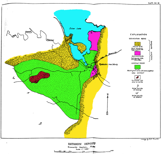
| ⓘ Pentlandite Formula: (NixFey)Σ9S8 Localities: Harriman prospect, Union, Knox County, Maine, USA Warren Nickel prospect, Warren, Knox County, Maine, USA Douglass Copper Mine, Blue Hill, Blue Hill - Castine Mining District, Hancock County, Maine, USA Katahdin Iron Works Mine, Katahdin Iron Works, Piscataquis County, Maine, USA Bergendahl prospect, Newfield, York County, Maine, USA |
| ⓘ Perhamite (TL) Formula: Ca3Al7.7Si3P4O23.5(OH)14.1 · 8H2O Localities: Reported from at least 8 localities in this region. Type Locality: Bell pit, Newry, Oxford County, Maine, USA References: |
| ⓘ Perloffite Formula: Ba(Mn2+,Fe2+)2Fe3+2(PO4)3(OH)3 |
| ⓘ Petalite Formula: LiAl(Si4O10) Localities: Reported from at least 9 localities in this region. |
| ⓘ Pezzottaite Formula: Cs(Be2Li)Al2(Si6O18) |
| ⓘ Pharmacosiderite Formula: KFe3+4(AsO4)3(OH)4 · 6-7H2O |
| ⓘ Phenakite Formula: Be2SiO4 Localities: Reported from at least 6 localities in this region. Description: Locality for some of the largest phenakite crystals known. |
| ⓘ Phlogopite Formula: KMg3(AlSi3O10)(OH)2 Localities: Reported from at least 10 localities in this region. References: |
| ⓘ Phosphoferrite Formula: (Fe2+,Mn2+)3(PO4)2 · 3H2O |
| ⓘ 'Phosphoferrite-Reddingite Series' ? |
| ⓘ Phosphophyllite Formula: Zn2Fe(PO4)2 · 4H2O Localities: |
| ⓘ Phosphosiderite Formula: FePO4 · 2H2O Localities: Reported from at least 11 localities in this region. |
| ⓘ Phosphuranylite Formula: KCa(H3O)3(UO2)7(PO4)4O4 · 8H2O Localities: Reported from at least 14 localities in this region. |
| ⓘ Pigeonite Formula: (CaxMgyFez)(Mgy1Fez1)Si2O6 Localities: Reported from at least 7 localities in this region. |
| ⓘ 'Pinite' |
| ⓘ 'Plagioclase' Formula: (Na,Ca)[(Si,Al)AlSi2]O8 Localities: Reported from at least 10 localities in this region. References: |
| ⓘ Platinum Formula: Pt |
| ⓘ Pollucite Formula: (Cs,Na)2(Al2Si4O12) · 2H2O Localities: Reported from at least 26 localities in this region. Description: Cubic and trapezohedral faces nearly equally developed. Cystal 2.5 x 2.5 cm in vug in massive pollucite. |
| ⓘ Powellite Formula: Ca(MoO4) Localities: Webster prospects (Sanford vesuvianite locality; Goodall Farm prospect; Webster vesuvianite prospect), Sanford, York County, Maine, USA Songo Pond Quarry (Kimball Ledge Quarry), Albany, Oxford County, Maine, USA Bergendahl prospect, Newfield, York County, Maine, USA Catherine Mountain Molybdenite prospect, Catherine Mountain, Hancock County, Maine, USA ? (more information) |
| ⓘ Prehnite Formula: Ca2Al2Si3O10(OH)2 Localities: Reported from at least 20 localities in this region. References: |
| ⓘ Formula: Ag3AsS3 Localities: |
| ⓘ Pseudolaueite Formula: Mn2+Fe3+2(PO4)2(OH)2 · 8H2O Localities: |
| ⓘ Pumpellyite-(Fe2+) Formula: Ca2Fe2+Al2(Si2O7)(SiO4)(OH,O)2 · H2O |
| ⓘ Pumpellyite-(Mg) Formula: Ca2MgAl2(Si2O7)(SiO4)(OH)2 · H2O Localities: |
| ⓘ 'Pumpellyite Subgroup' Formula: Ca2XAl2[Si2O6(OH)][SiO4](OH)2A Localities: References: |
| ⓘ Purpurite Formula: Mn3+(PO4) Localities: Reported from at least 15 localities in this region. Description: Moore (2000) analyzed lithiophilite from this locality and found the Mn/Mn + Fe ratio was 0.51 No primary lithiophilite remains at the locality. |
| ⓘ Pyrargyrite Formula: Ag3SbS3 Localities: |
| ⓘ Pyrite Formula: FeS2 Localities: Reported from at least 201 localities in this region. References: |
| ⓘ Pyrite var. Bravoite Formula: (Fe,Ni)S2 Localities: |
| ⓘ 'Pyrochlore Supergroup' Formula: A2-mD2X6-wZ1-n |
| ⓘ 'Pyrochlore Supergroup var. Betafite (of Hogarth 1977)' Formula: (Ca,Na,U)2(Ti, Nb,Ta)2O6Z(OH) |
| ⓘ Formula: Mn4+O2 Localities: Reported from at least 6 localities in this region. |
| ⓘ Pyromorphite Formula: Pb5(PO4)3Cl Localities: |
| ⓘ Pyrophanite Formula: Mn2+TiO3 Localities: Hovey Mountain Manganese Prospect, T3 R9 WELS, Aroostook County, Maine, USA Symmes Pond Syenite, Straw Hill occurrence, Newfield, York County, Maine, USA Lower Maple Mountain Manganese Prospect, TD R2 WELS, Aroostook County, Maine, USA Upper Maple Mountain manganese prospect, TD R2 WELS, Aroostook County, Maine, USA Ryerson Hill Quarries, Paris, Oxford County, Maine, USA |
| ⓘ Pyrophyllite Formula: Al2Si4O10(OH)2 |
| ⓘ 'Pyroxene Group' Formula: ADSi2O6 Localities: Reported from at least 6 localities in this region. |
| ⓘ Pyrrhotite Formula: Fe1-xS Localities: Reported from at least 67 localities in this region. |
| ⓘ Pyrrhotite var. Nickel-bearing Pyrrhotite Formula: (Fe,Ni)7S8 |
| ⓘ Quartz Formula: SiO2 Localities: Reported from at least 657 localities in this region. Description: Transparent floater pseudocubic quartz crystals to 2 cm. |
| ⓘ Quartz var. Agate Localities: |
| ⓘ Quartz var. Amethyst Formula: SiO2 Localities: Reported from at least 30 localities in this region. |
| ⓘ Quartz var. Blue Quartz Formula: SiO2 |
| ⓘ Quartz var. Carnelian Localities: |
| ⓘ Quartz var. Chalcedony Formula: SiO2 Localities: Reported from at least 12 localities in this region. |
| ⓘ Quartz var. Citrine Formula: SiO2 Localities: Tamminen Quarry, Greenwood, Oxford County, Maine, USA Keith Quarry (Towne Quarry), West Mount Apatite Mining District, Auburn, Androscoggin County, Maine, USA Maine Feldspar Quarry, East Mount Apatite Mining District, Auburn, Androscoggin County, Maine, USA Consolidated Feldspar Quarries, Georgetown, Sagadahoc County, Maine, USA ? (more information) Hatch Farm prospect, East Mount Apatite Mining District, Auburn, Androscoggin County, Maine, USA ? (more information) References: |
| ⓘ Quartz var. Milky Quartz Formula: SiO2 Localities: Reported from at least 20 localities in this region. |
| ✪ Quartz var. Pseudocubic Quartz Formula: SiO2 Habit: Pseudocubic appearance due to equal development of "r" faces and near absence of prism faces. Colour: Transparent, colorless Fluorescence: None |
| ⓘ Quartz var. Rock Crystal Formula: SiO2 Localities: Reported from at least 11 localities in this region. |
| ⓘ Quartz var. Rose Quartz Formula: SiO2 Localities: Reported from at least 62 localities in this region. Description: Individual rose quartz crystals to over 2.5 cm have been found at this location with eosphorite crystals, montebrasite crystals, and other phosphates on albite crystal matrix. Groups of Rose Quartz Crystals to over 10 x 10 cm have been discovered. |
| ⓘ Quartz var. Rutilated Quartz Formula: SiO2 |
| ⓘ Quartz var. Sceptre Quartz Formula: SiO2 Localities: References: |
| ⓘ Quartz var. Smoky Quartz Formula: SiO2 Localities: Reported from at least 99 localities in this region. |
| ⓘ Rammelsbergite Formula: NiAs2 |
| ⓘ Realgar Formula: As4S4 |
| ⓘ Reddingite Formula: (Mn2+,Fe2+)3(PO4)2 · 3H2O Localities: Emmons Quarry, Uncle Tom Mountain, Greenwood, Oxford County, Maine, USA Bennett Quarry, Buckfield, Oxford County, Maine, USA Berry-Havey Quarry (Havey Quarry; Berry Quarry), Poland, Androscoggin County, Maine, USA Dunton Gem Quarry, Newry, Oxford County, Maine, USA ? (more information) |
| ⓘ Rhodochrosite Formula: MnCO3 Localities: Reported from at least 22 localities in this region. Description: Possibly world's largest crystals from a granite pegmatite. |
| ⓘ Rhodonite Formula: CaMn3Mn[Si5O15] Localities: Reported from at least 6 localities in this region. |
| ⓘ 'Rhombohedral Carbonate' Formula: (Ca/Mg/Fe/Mn etc)CO3 |
| ⓘ Riebeckite Formula: ◻[Na2][Fe2+3Fe3+2]Si8O22(OH)2 Localities: Reported from at least 6 localities in this region. |
| ⓘ Robertsite Formula: Ca2Mn3+3(PO4)3O2 · 3H2O Localities: |
| ⓘ Rockbridgeite Formula: Fe2+Fe3+4(PO4)3(OH)5 Localities: Reported from at least 11 localities in this region. |
| ⓘ Romanèchite Formula: (Ba,H2O)2(Mn4+,Mn3+)5O10 Localities: Reported from at least 7 localities in this region. Description: Localities which had psilomelane reported have been indiscriminately relabeled as romanèchite. As in this case, the original material was never analyzed and the listing appears erroneous. |
| ⓘ Rosasite Formula: (Cu,Zn)2(CO3)(OH)2 |
| ⓘ Roscherite Formula: Ca2Mn2+5Be4(PO4)6(OH)4 · 6H2O Localities: Reported from at least 9 localities in this region. |
| ⓘ Rossmanite Formula: ◻(LiAl2)Al6(Si6O18)(BO3)3(OH)3(OH) Localities: |
| ⓘ Rutherfordine Formula: (UO2)CO3 |
| ⓘ Rutile Formula: TiO2 Localities: Reported from at least 22 localities in this region. |
| ⓘ Rutile var. Ilmenorutile Formula: (Ti,Nb)O2 Localities: |
| ⓘ Safflorite Formula: (Co,Ni,Fe)As2 |
| ⓘ Formula: YFe3+Nb2O8 Localities: |
| ⓘ Sanidine Formula: K(AlSi3O8) |
| ⓘ Saponite Formula: Ca0.25(Mg,Fe)3((Si,Al)4O10)(OH)2 · nH2O Localities: |
| ⓘ 'Scapolite' Localities: Reported from at least 6 localities in this region. |
| ⓘ Schafarzikite Formula: Fe2+Sb3+2O4 |
| ⓘ Scheelite Formula: Ca(WO4) Localities: Reported from at least 19 localities in this region. |
| ⓘ Schoepite Formula: (UO2)8O2(OH)12 · 12H2O Localities: Reported from at least 11 localities in this region. |
| ⓘ Schoonerite Formula: ZnMn2+Fe2+2Fe3+(PO4)3(OH)2 · 9H2O Localities: |
| ⓘ Schorl Formula: NaFe2+3Al6(Si6O18)(BO3)3(OH)3(OH) Localities: Reported from at least 216 localities in this region. Description: Well-terminated but low luster crystals to over 10 cm known. |
| ⓘ ' Locality: Noyes Mountain Quarry (Harvard Quarry), Greenwood, Oxford County, Maine, USA - erroneously reported Description: One specimen was observed that had a schrötterite identification, but was a clayey alteration of microcline and could have been montmorillonite. |
| ⓘ Scolecite Formula: CaAl2Si3O10 · 3H2O |
| ⓘ Scorodite Formula: Fe3+AsO4 · 2H2O Localities: Reported from at least 8 localities in this region. References: |
| ⓘ Scorzalite Formula: Fe2+Al2(PO4)2(OH)2 Localities: Reported from at least 6 localities in this region. |
| ⓘ Sekaninaite Formula: (Fe,Mg)2Al3(AlSi5O18) |
| ⓘ 'Serpentine Subgroup' Formula: D3[Si2O5](OH)4 Localities: Reported from at least 9 localities in this region. |
| ⓘ 'Serpentine Subgroup var. Retinalite' Formula: D3[Si2O5](OH)4 D= Mg, Fe, Ni, Mn, Al, Zn Localities: |
| ⓘ Serpierite Formula: Ca(Cu,Zn)4(SO4)2(OH)6 · 3H2O |
| ⓘ Sewardite Formula: CaFe3+2(AsO4)2(OH)2 |
| ⓘ Siderite Formula: FeCO3 Localities: Reported from at least 37 localities in this region. |
| ⓘ Sillimanite Formula: Al2(SiO4)O Localities: Reported from at least 30 localities in this region. |
| ⓘ Sillimanite var. Fibrolite Formula: Al2(SiO4)O Locality: Stow, Oxford County, Maine, USA |
| ⓘ Silver Formula: Ag Localities: Reported from at least 14 localities in this region. |
| ⓘ 'Smectite Group' Formula: A0.3D2-3[T4O10]Z2 · nH2O Localities: |
| ⓘ Smithsonite Formula: ZnCO3 Localities: Cape Rosier Mine (Callahan Mine; Rosier Consolidated Mine), Brooksville, Blue Hill - Castine Mining District, Hancock County, Maine, USA Lubec Lead Mine (Solomon Thayer Mine), Lubec, Washington County, Maine, USA Black Hawk Mine, Blue Hill, Blue Hill - Castine Mining District, Hancock County, Maine, USA Big Hill Mine, Pembroke, Washington County, Maine, USA Dolsan prospect (Barrett prospect), Pembroke, Washington County, Maine, USA References: |
| ⓘ Sodalite Formula: Na4(Si3Al3)O12Cl Localities: Reported from at least 6 localities in this region. |
| ⓘ Souzalite Formula: (Mg,Fe2+)3(Al,Fe3+)4(PO4)4(OH)6 · 2H2O |
| ⓘ Sperrylite Formula: PtAs2 Localities: |
| ⓘ Spessartine Formula: Mn2+3Al2(SiO4)3 Localities: Reported from at least 13 localities in this region. |
| ⓘ Sphalerite Formula: ZnS Localities: Reported from at least 92 localities in this region. |
| ⓘ Sphalerite var. Marmatite Formula: (Zn,Fe)S Localities: |
| ⓘ Spinel Formula: MgAl2O4 Localities: Harriman prospect, Union, Knox County, Maine, USA Warren Nickel prospect, Warren, Knox County, Maine, USA Bombazine Island, Harpswell, Cumberland County, Maine, USA Pulsifer Quarry & Dionne extension, West Mount Apatite Mining District, Auburn, Androscoggin County, Maine, USA |
| ⓘ Spodumene Formula: LiAlSi2O6 Localities: Reported from at least 46 localities in this region. Habit: elongated prismatic Colour: white, pale lilac to tan Fluorescence: purple under SW UV, less intense purple under MW UV, orange under LW UV Description: Crystals to at least 10 cm associated with quartz, cleavelandite, pollucite and montebrasite. |
| ⓘ Spodumene var. Kunzite Formula: LiAlSi2O6 Localities: Dunton Gem Quarry, Newry, Oxford County, Maine, USA Georgetown, Sagadahoc County, Maine, USA Auburn, Androscoggin County, Maine, USA Greenlaw Quarry, East Mount Apatite Mining District, Auburn, Androscoggin County, Maine, USA ? (more information) B.B. No. 7 Quarry, Norway, Oxford County, Maine, USA ? (more information) Description: Transparent, gem quality and mostly flawless kunzite has been found as a single specimen (~4x4x1 cm) at the Dunton Quarry. Pink spodumene that is not of gem quality does not qualify as kunzite. |
| ⓘ Stannite Formula: Cu2FeSnS4 Localities: |
| ⓘ Staurolite Formula: Fe2+2Al9Si4O23(OH) Localities: Reported from at least 15 localities in this region. Description: Vitreous smooth-faced staurilte crystals, uncommonly with St. Andrews twins and rarely with Maltese Cross twins to 10 x 5 cm. |
| ⓘ Stellerite Formula: Ca4(Si28Al8)O72 · 28H2O |
| ⓘ Stephanite Formula: Ag5SbS4 Localities: |
| ⓘ Stevensite Formula: (Ca,Na)xMg3-x(Si4O10)(OH)2 Localities: |
| ⓘ Stewartite Formula: Mn2+Fe3+2(PO4)2(OH)2 · 8H2O Localities: Reported from at least 7 localities in this region. References: |
| ⓘ Stibiotantalite Formula: Sb(Ta,Nb)O4 |
| ⓘ Stibnite Formula: Sb2S3 Localities: Reported from at least 6 localities in this region. Description: Large cleavages to over 10 x 2 cm. |
| ⓘ Stilbite-Ca Formula: NaCa4(Si27Al9)O72 · 28H2O Localities: |
| ⓘ 'Stilbite Subgroup' Formula: M6-7[Al8-9Si27-28O72] · nH2O Localities: |
| ⓘ Stilpnomelane Formula: (K,Ca,Na)(Fe,Mg,Al)8(Si,Al)12(O,OH)36 · nH2O Localities: Reported from at least 9 localities in this region. Habit: Crystals to 1cm References: |
| ⓘ Formula: Pb(WO4) Locality: Bennett Quarry, Buckfield, Oxford County, Maine, USA - erroneously reported Description: Specimen was a hoax sold as another mineral. Not a specimen from this locality. |
| ⓘ Strengite Formula: FePO4 · 2H2O Localities: |
| ⓘ Stromeyerite Formula: AgCuS Localities: |
| ⓘ Strunzite Formula: Mn2+Fe3+2(PO4)2(OH)2 · 6H2O Localities: Reported from at least 17 localities in this region. |
| ⓘ 'Strunzite Group' |
| ⓘ Formula: (NH4)Mg(PO4) · 6H2O Locality: Red Hill quarries, Rumford, Oxford County, Maine, USA - erroneously reported Description: Typographical error for strunzite. |
| ⓘ Sulphur Formula: S8 Localities: Cape Rosier Mine (Callahan Mine; Rosier Consolidated Mine), Brooksville, Blue Hill - Castine Mining District, Hancock County, Maine, USA Katahdin Iron Works Mine, Katahdin Iron Works, Piscataquis County, Maine, USA Drew Hill Antimony Prospect, Linneus, Aroostook County, Maine, USA Acton, York County, Maine, USA |
| ⓘ Switzerite Formula: Mn2+3(PO4)2 · 7H2O Localities: Reported from at least 6 localities in this region. |
| ⓘ Sylvanite Formula: AgAuTe4 |
| ⓘ 'Synchysite' Formula: Ca(Ce/Nd/Y/REE)(CO3)2F |
| ⓘ Talc Formula: Mg3Si4O10(OH)2 Localities: Reported from at least 14 localities in this region. References: |
| ⓘ Talc var. Steatite Formula: Mg3(Si4O10)(OH)2 |
| ⓘ ' Formula: (Mn,Fe)(Ta,Nb)2O6 Locality: Mount Mica Quarry, Paris, Oxford County, Maine, USA - erroneously reported Description: Tantalite is very uncommon and many "tantalite" compositions found worldwide are actually tapiolites. |
| ⓘ Tantalite-(Fe) Formula: Fe2+Ta2O6 Localities: |
| ⓘ Tantalite-(Mn) Formula: Mn2+Ta2O6 Localities: Reported from at least 17 localities in this region. |
| ⓘ Tantalowodginite (TL) Formula: (Mn2+0.5◻0.5)TaTa2O8 Type Locality: |
| ⓘ 'Tapiolite' Formula: (Fe,Mn)(Ta,Nb)2O6 Localities: |
| ⓘ Tapiolite-(Fe) Formula: Fe2+Ta2O6 Localities: |
| ⓘ Tapiolite-(Mn) Formula: Mn2+Ta2O6 |
| ⓘ Formula: Te Locality: Golden Circle mine, Sorrento, Hancock County, Maine, USA - erroneously reported |
| ⓘ 'Tennantite Subgroup' Formula: Cu6(Cu4C2+2)As4S12S Localities: Cape Rosier Mine (Callahan Mine; Rosier Consolidated Mine), Brooksville, Blue Hill - Castine Mining District, Hancock County, Maine, USA Douglass Copper Mine, Blue Hill, Blue Hill - Castine Mining District, Hancock County, Maine, USA Sullivan Silver mines, Sullivan Mining District, Sullivan, Hancock County, Maine, USA References: |
| ⓘ Tenorite Formula: CuO Localities: |
| ⓘ Tetradymite Formula: Bi2Te2S Localities: |
| ⓘ 'Tetrahedrite Subgroup' Formula: Cu6(Cu4C2+2)Sb4S12S Localities: Reported from at least 6 localities in this region. References: |
| ⓘ Formula: NaCa2[Al5Si5O20] · 6H2O Locality: Litchfield, Kennebec County, Maine, USA - erroneously reported Description: Unbelievable report based on an analysis of a fine-grained mixture before the days of X-ray diffraction, etc. |
| ⓘ Thorianite Formula: ThO2 |
| ⓘ Thorite Formula: Th(SiO4) |
| ✪ Thorite var. Thorogummite Formula: (Th,U)(SiO4)1-x(OH)4x Description: Sharp yellow rod-like crystals to several mm with simple pyramids |
| ⓘ Titanite Formula: CaTi(SiO4)O Localities: Reported from at least 48 localities in this region. |
| ⓘ 'Titanite Group' |
| ⓘ Todorokite Formula: (Na,Ca,K,Ba,Sr)1-x(Mn,Mg,Al)6O12 · 3-4H2O Localities: Reported from at least 17 localities in this region. |
| ⓘ Topaz Formula: Al2(SiO4)(F,OH)2 Localities: Reported from at least 11 localities in this region. Description: One 5 cm crystal found before 1925. |
| ⓘ Torbernite Formula: Cu(UO2)2(PO4)2 · 12H2O Localities: Reported from at least 24 localities in this region. |
| ⓘ Tosudite Formula: Na0.5(Al,Mg)6((Si,Al)8O18)(OH)12 · 5H2O Localities: Description: This is tosudite-Li |
| ⓘ Tosudite var. Lithium Tosudite Formula: Na0.5(Al,Mg)6((Si,Al)8O18)(OH)12 · 5H2O Localities: |
| ⓘ 'Tourmaline' Formula: AD3G6 (T6O18)(BO3)3X3Z Localities: Reported from at least 38 localities in this region. Description: Black Mountain Mine is noted for its "fans" of pink elbaite - some as large as perhaps a foot high and across. The material is largely non-gem quality to "representative" quality. Really good quality crystals are quite rare here. It is the size and aesthetics of the "fans" which have attracted collector attention to the locality over the years. |
| ⓘ 'Tourmaline var. Achroite' Formula: A(D3)G6(T6O18)(BO3)3X3Z Localities: Mount Mica Quarry, Paris, Oxford County, Maine, USA Dunton Gem Quarry, Newry, Oxford County, Maine, USA Pulsifer Quarry & Dionne extension, West Mount Apatite Mining District, Auburn, Androscoggin County, Maine, USA Mount Rubellite Quarries, Mount Rubellite, Hebron, Oxford County, Maine, USA Ski Pike Quarry, West Paris, Oxford County, Maine, USA Habit: Prismatic transparent flawless crystals; also as large zones in polychrome crystals. Colour: Colorless, may grade to barely perceptible shades of pale pink or pale green. |
| ⓘ 'Tourmaline var. Rubellite' Formula: A(D3)G6(T6O18)(BO3)3X3Z Localities: Reported from at least 14 localities in this region. Description: Black Mountain Mine is noted for its "fans" of pink elbaite - some as large as perhaps a foot high and across. The material is largely non-gem quality to "representative" quality. Really good quality crystals are quite rare here. It is the size and aesthetics of the "fans" which have attracted collector attention to the locality over the years. |
| ⓘ 'Tourmaline var. Verdelite' Formula: A(D3)G6(T6O18)(BO3)3X3Z Localities: Reported from at least 19 localities in this region. References: |
| ⓘ 'Tourmaline var. Watermelon Tourmaline' Formula: A(D3)G6(T6O18)(BO3)3X3Z Localities: Reported from at least 11 localities in this region. Habit: Very gemmy large single crystals of watermelon tourmaline occur to over 10 cm long. Colour: Green and red. Description: The "type" locality for watermelon tourmaline is the Berry-Havey Quarry in Poland, Maine, USA. |
| ⓘ Tremolite Formula: ◻Ca2Mg5(Si8O22)(OH)2 Localities: Reported from at least 13 localities in this region. |
| ⓘ Tridymite Formula: SiO2 |
| ⓘ Triphylite Formula: LiFe2+PO4 Localities: Reported from at least 34 localities in this region. Habit: Rod-like through blocky habit Colour: greenish gray Fluorescence: none Description: Best Quality crystals were found in the intermediate zone. Well terminated crystals to 20 cm, although not as fine as those from Newport, NH. King and Pope (1990) analyzed triphylites from this locality and found that the analyses ranged from 0.32-0.34 in about 15 analyses. |
| ⓘ Triphylite var. Ferrisicklerite Formula: Li1-x(Fe3+xFe2+1-x)PO4 Localities: |
| ⓘ Triplite Formula: Mn2+2(PO4)F Localities: Reported from at least 12 localities in this region. |
| ⓘ Triploidite Formula: Mn2+2(PO4)(OH) Localities: |
| ⓘ Troilite Formula: FeS Description: In Basaltic Clast |
| ⓘ Ulvöspinel Formula: TiFe2+2O4 |
| ⓘ 'UM1956-01-O:HPbU' Formula: Pb-U-O-H Locality: Newry, Oxford County, Maine, USA |
| ⓘ 'UM2009-11-PO:CaHZr' Formula: CaZr[PO4]2 · 4H2O |
| ⓘ 'Unnamed (Zirconium Monohydroxyorthophosphate Tetrahydrate)' Formula: Zr(PO3OH)2(H2O)4 |
| ⓘ Uralolite Formula: Ca2Be4(PO4)3(OH)3 · 5H2O Localities: Habit: fibrous aggregates of minute radiating bladed crystals Colour: white |
| ⓘ Uraninite Formula: UO2 Localities: Reported from at least 56 localities in this region. Description: The uraninites from this locality are among the finest in the world for brightness and sharpness of crystals. The largest crystals are about 2.5 cm in each direction. Chemical analysis shows them to be essentially unoxidized. |
| ⓘ Uraninite var. Pitchblende Formula: UO2 Localities: |
| ⓘ Uranophane Formula: Ca(UO2)2(SiO3OH)2 · 5H2O Localities: Reported from at least 22 localities in this region. |
| ⓘ Ushkovite Formula: MgFe3+2(PO4)2(OH)2 · 8H2O |
| ⓘ Uvarovite Formula: Ca3Cr2(SiO4)3 |
| ⓘ Vaesite Formula: NiS2 |
| ⓘ Valentinite Formula: Sb2O3 |
| ⓘ Valleriite Formula: (Fe2+,Cu)4(Mg,Al)3S4(OH,O)6 Localities: |
| ⓘ Vandendriesscheite Formula: PbU7O22 · 12H2O |
| ⓘ Vanmeersscheite Formula: U6+(UO2)3(PO4)2(OH)6 · 4H2O |
| ⓘ Väyrynenite Formula: BeMn2+(PO4)(OH) Localities: |
| ⓘ Vesuvianite Formula: Ca19Fe3+Al4(Al6Mg2)(◻4)◻[Si2O7]4[(SiO4)10]O(OH)9 Localities: Reported from at least 34 localities in this region. Habit: square prismatic Colour: olive green |
| ⓘ Violarite Formula: Fe2+Ni3+2S4 |
| ⓘ Vivianite Formula: Fe2+Fe2+2(PO4)2 · 8H2O Localities: Reported from at least 21 localities in this region. |
| ⓘ Wagnerite Formula: (Mg,Fe2+)2(PO4)F |
| ⓘ Walentaite Formula: Fe3+3(P0.84As0.16O4)2(O,OH)6As3+2.56Ca0.42Na0.28Mn2+0.35Fe2+0.30O6.1(OH)0.9(H2O)0.9 |
| ⓘ Wardite Formula: NaAl3(PO4)2(OH)4 · 2H2O Localities: |
| ⓘ Whitlockite Formula: Ca9Mg(PO4)6(PO3OH) Localities: |
| ⓘ Whitmoreite Formula: Fe2+Fe3+2(PO4)2(OH)2 · 4H2O Localities: Bell pit, Newry, Oxford County, Maine, USA Ryerson Hill Quarries, Paris, Oxford County, Maine, USA Crooker Gem Pegmatite Quarries, Newry, Oxford County, Maine, USA Emmons Quarry, Uncle Tom Mountain, Greenwood, Oxford County, Maine, USA ? (more information) Estes Quarry, West Baldwin, Baldwin, Cumberland County, Maine, USA ? (more information) |
| ⓘ Wodginite Formula: Mn2+Sn4+Ta2O8 Localities: Reported from at least 7 localities in this region. References: |
| ⓘ Wolfeite Formula: Fe2+2(PO4)(OH) |
| ⓘ 'Wolframite Group' |
| ⓘ Wollastonite Formula: Ca3(Si3O9) Localities: Reported from at least 7 localities in this region. |
| ⓘ Wölsendorfite Formula: Pb7(UO2)14O19(OH)4 · 12H2O Localities: |
| ⓘ Wulfenite Formula: Pb(MoO4) Localities: |
| ⓘ Wurtzite Formula: (Zn,Fe)S |
| ⓘ Xanthoxenite Formula: Ca4Fe3+2(PO4)4(OH)2 · 3H2O Localities: Reported from at least 7 localities in this region. |
| ⓘ 'Xenotime' |
| ⓘ Xenotime-(Y) Formula: Y(PO4) Localities: Havey #1 & #2 Quarries, Topsham, Sagadahoc County, Maine, USA Yedlin Locality, Topsham, Sagadahoc County, Maine, USA Lost Quarry, Topsham, Sagadahoc County, Maine, USA Mount Mica Quarry, Paris, Oxford County, Maine, USA Berry-Havey Quarry (Havey Quarry; Berry Quarry), Poland, Androscoggin County, Maine, USA |
| ⓘ Zanazziite Formula: Ca2Mg5Be4(PO4)6(OH)4 · 6H2O Localities: |
| ⓘ Zigrasite (TL) Formula: MgZr(PO4)2 · 4H2O Type Locality: |
| ⓘ 'Zinnwaldite' Localities: |
| ⓘ Zircon Formula: Zr(SiO4) Localities: Reported from at least 83 localities in this region. |
| ⓘ Zircon var. Cyrtolite Formula: Zr[(SiO4),(OH)4] Localities: |
| ⓘ Zoisite Formula: (CaCa)(AlAlAl)O[Si2O7][SiO4](OH) Localities: |
| ⓘ Zwieselite ? Formula: Fe2+2(PO4)F Description: Currently designated "Unknown #6" in Mineralogy of Maine volumes 1 and 2. Chemical analysis indicates a iron-rich phosphate fluoride with some manganese. XRD was inconclusive. |
Gallery:

(Ca,Mn2+)5(PO4)3(F,Cl,OH) or Ca5([P,Mn5+]O4)3(F,Cl,OH)ⓘ Fluorapatite var. Manganese-bearing Fluorapatite
List of minerals arranged by Strunz 10th Edition classification
| Group 1 - Elements | |||
|---|---|---|---|
| ⓘ | Silver | 1.AA.05 | Ag |
| ⓘ | Gold | 1.AA.05 | Au |
| ⓘ | Copper | 1.AA.05 | Cu |
| ⓘ | Platinum | 1.AF.10 | Pt |
| ⓘ | Niggliite | 1.AG.60 | PtSn |
| ⓘ | Bismuth | 1.CA.05 | Bi |
| ⓘ | Graphite | 1.CB.05a | C |
| ⓘ | Sulphur | 1.CC.05 | S8 |
| ⓘ | Tellurium ? | 1.CC.10 | Te |
| Group 2 - Sulphides and Sulfosalts | |||
| ⓘ | Chalcocite | 2.BA.05 | Cu2S |
| ⓘ | Bornite | 2.BA.15 | Cu5FeS4 |
| ⓘ | Acanthite | 2.BA.35 | Ag2S |
| ⓘ | Stromeyerite | 2.BA.40 | AgCuS |
| ⓘ | Pentlandite | 2.BB.15 | (NixFey)Σ9S8 |
| ⓘ | Covellite | 2.CA.05a | CuS |
| ⓘ | Hawleyite ? | 2.CB.05a | CdS |
| ⓘ | Sphalerite var. Marmatite | 2.CB.05a | (Zn,Fe)S |
| ⓘ | 2.CB.05a | ZnS | |
| ⓘ | Chalcopyrite | 2.CB.10a | CuFeS2 |
| ⓘ | Stannite | 2.CB.15a | Cu2FeSnS4 |
| ⓘ | Greenockite | 2.CB.45 | CdS |
| ⓘ | Wurtzite | 2.CB.45 | (Zn,Fe)S |
| ⓘ | Cubanite | 2.CB.55a | CuFe2S3 |
| ⓘ | Nickeline | 2.CC.05 | NiAs |
| ⓘ | Pyrrhotite var. Nickel-bearing Pyrrhotite | 2.CC.10 | (Fe,Ni)7S8 |
| ⓘ | 2.CC.10 | Fe1-xS | |
| ⓘ | Troilite | 2.CC.10 | FeS |
| ⓘ | Mackinawite | 2.CC.25 | FeS |
| ⓘ | Galena | 2.CD.10 | PbS |
| ⓘ | var. Silver-bearing Galena | 2.CD.10 | PbS with Ag |
| ⓘ | Violarite | 2.DA.05 | Fe2+Ni3+2S4 |
| ⓘ | Linnaeite | 2.DA.05 | Co2+Co3+2S4 |
| ⓘ | Metastibnite | 2.DB.05 | Sb2S3 |
| ⓘ | Stibnite | 2.DB.05 | Sb2S3 |
| ⓘ | Bismuthinite | 2.DB.05 | Bi2S3 |
| ⓘ | Tetradymite | 2.DC.05 | Bi2Te2S |
| ⓘ | Sylvanite | 2.EA.05 | AgAuTe4 |
| ⓘ | Molybdenite | 2.EA.30 | MoS2 |
| ⓘ | Vaesite | 2.EB.05a | NiS2 |
| ⓘ | Pyrite var. Bravoite | 2.EB.05a | (Fe,Ni)S2 |
| ⓘ | 2.EB.05a | FeS2 | |
| ⓘ | Sperrylite | 2.EB.05a | PtAs2 |
| ⓘ | Marcasite | 2.EB.10a | FeS2 |
| ⓘ | Löllingite | 2.EB.15a | FeAs2 |
| ⓘ | Rammelsbergite | 2.EB.15a | NiAs2 |
| ⓘ | Safflorite | 2.EB.15a | (Co,Ni,Fe)As2 |
| ⓘ | Arsenopyrite | 2.EB.20 | FeAsS |
| ⓘ | Cobaltite ? | 2.EB.25 | CoAsS |
| ⓘ | Gersdorffite | 2.EB.25 | NiAsS |
| ⓘ | Realgar | 2.FA.15a | As4S4 |
| ⓘ | Valleriite | 2.FD.30 | (Fe2+,Cu)4(Mg,Al)3S4(OH,O)6 |
| ⓘ | Pyrargyrite | 2.GA.05 | Ag3SbS3 |
| ⓘ | Proustite ? | 2.GA.05 | Ag3AsS3 |
| ⓘ | Bournonite | 2.GA.50 | PbCuSbS3 |
| ⓘ | 'Tennantite Subgroup' | 2.GB.05 | Cu6(Cu4C2+2)As4S12S |
| ⓘ | 'Tetrahedrite Subgroup' | 2.GB.05 | Cu6(Cu4C2+2)Sb4S12S |
| ⓘ | Stephanite | 2.GB.10 | Ag5SbS4 |
| ⓘ | Boulangerite | 2.HC.15 | Pb5Sb4S11 |
| ⓘ | Enargite | 2.KA.05 | Cu3AsS4 |
| Group 3 - Halides | |||
| ⓘ | Chlorargyrite ? | 3.AA.15 | AgCl |
| ⓘ | Halite | 3.AA.20 | NaCl |
| ⓘ | Fluorite | 3.AB.25 | CaF2 |
| Group 4 - Oxides and Hydroxides | |||
| ⓘ | Goethite | 4.00. | α-Fe3+O(OH) |
| ⓘ | 'Microlite Group' | 4.00. | A2-mTa2X6-wZ-n |
| ⓘ | Ice | 4.AA.05 | H2O |
| ⓘ | Cuprite | 4.AA.10 | Cu2O |
| ⓘ | Tenorite | 4.AB.10 | CuO |
| ⓘ | Chrysoberyl | 4.BA.05 | BeAl2O4 |
| ⓘ | Magnesiochromite ? | 4.BB.05 | MgCr2O4 |
| ⓘ | Magnetite | 4.BB.05 | Fe2+Fe3+2O4 |
| ⓘ | Spinel | 4.BB.05 | MgAl2O4 |
| ⓘ | Hercynite | 4.BB.05 | Fe2+Al2O4 |
| ⓘ | Chromite | 4.BB.05 | Fe2+Cr3+2O4 |
| ⓘ | Gahnite | 4.BB.05 | ZnAl2O4 |
| ⓘ | Hercynite var. Picotite ? | 4.BB.05 | (Fe,Mg)(Al,Cr)2O4 |
| ⓘ | Ulvöspinel | 4.BB.05 | TiFe2+2O4 |
| ⓘ | Hausmannite | 4.BB.10 | Mn2+Mn3+2O4 |
| ⓘ | Hematite | 4.CB.05 | Fe2O3 |
| ⓘ | var. Specularite | 4.CB.05 | Fe2O3 |
| ⓘ | Pyrophanite | 4.CB.05 | Mn2+TiO3 |
| ⓘ | Ilmenite | 4.CB.05 | Fe2+TiO3 |
| ⓘ | Corundum | 4.CB.05 | Al2O3 |
| ⓘ | Arsenolite | 4.CB.50 | As2O3 |
| ⓘ | Valentinite | 4.CB.55 | Sb2O3 |
| ⓘ | Lueshite | 4.CC.30 | NaNbO3 |
| ⓘ | Natroniobite | 4.CC.30 | NaNbO3 |
| ⓘ | Loparite-(Ce) | 4.CC.35 | (Na,REE)2Ti2O6 |
| ⓘ | Quartz var. Blue Quartz | 4.DA.05 | SiO2 |
| ⓘ | var. Citrine | 4.DA.05 | SiO2 |
| ⓘ | var. Smoky Quartz | 4.DA.05 | SiO2 |
| ⓘ | var. Carnelian | 4.DA.05 | SiO2 |
| ⓘ | var. Rutilated Quartz | 4.DA.05 | SiO2 |
| ⓘ | var. Rose Quartz | 4.DA.05 | SiO2 |
| ⓘ | var. Milky Quartz | 4.DA.05 | SiO2 |
| ⓘ | var. Amethyst | 4.DA.05 | SiO2 |
| ⓘ | var. Rock Crystal | 4.DA.05 | SiO2 |
| ⓘ | 4.DA.05 | SiO2 | |
| ⓘ | var. Agate | 4.DA.05 | SiO2 |
| ⓘ | var. Pseudocubic Quartz | 4.DA.05 | SiO2 |
| ⓘ | var. Sceptre Quartz | 4.DA.05 | SiO2 |
| ⓘ | var. Chalcedony | 4.DA.05 | SiO2 |
| ⓘ | Opal var. Opal-AN | 4.DA.10 | SiO2 · nH2O |
| ⓘ | 4.DA.10 | SiO2 · nH2O | |
| ⓘ | var. Hyalite | 4.DA.10 | SiO2 · nH2O |
| ⓘ | Tridymite | 4.DA.10 | SiO2 |
| ⓘ | Cassiterite | 4.DB.05 | SnO2 |
| ⓘ | Rutile | 4.DB.05 | TiO2 |
| ⓘ | Pyrolusite ? | 4.DB.05 | Mn4+O2 |
| ⓘ | Rutile var. Ilmenorutile | 4.DB.05 | (Ti,Nb)O2 |
| ⓘ | Tapiolite-(Mn) | 4.DB.10 | Mn2+Ta2O6 |
| ⓘ | Tapiolite-(Fe) | 4.DB.10 | Fe2+Ta2O6 |
| ⓘ | Nsutite | 4.DB.15c | (Mn4+,Mn2+)(O,OH)2 |
| ⓘ | Ishikawaite | 4.DB.25 | U4+Fe2+Nb2O8 |
| ⓘ | Samarskite-(Y) ? | 4.DB.25 | YFe3+Nb2O8 |
| ⓘ | Hübnerite ? | 4.DB.30 | MnWO4 |
| ⓘ | Ferberite | 4.DB.30 | FeWO4 |
| ⓘ | 'Wolframite Group' | 4.DB.30 va | |
| ⓘ | Columbite-(Fe) | 4.DB.35 | Fe2+Nb2O6 |
| ⓘ | Columbite-(Mn) | 4.DB.35 | Mn2+Nb2O6 |
| ⓘ | Tantalite-(Mn) | 4.DB.35 | Mn2+Ta2O6 |
| ⓘ | Tantalite-(Fe) | 4.DB.35 | Fe2+Ta2O6 |
| ⓘ | Tantalowodginite (TL) | 4.DB.40 | (Mn2+0.5◻0.5)TaTa2O8 |
| ⓘ | Wodginite | 4.DB.40 | Mn2+Sn4+Ta2O8 |
| ⓘ | Lithiowodginite | 4.DB.40 | LiTa3O8 |
| ⓘ | Anatase | 4.DD.05 | TiO2 |
| ⓘ | Brookite | 4.DD.10 | TiO2 |
| ⓘ | Stibiotantalite | 4.DE.30 | Sb(Ta,Nb)O4 |
| ⓘ | Fersmite | 4.DG.05 | (Ca,Ce,Na)(Nb,Ta,Ti)2(O,OH,F)6 |
| ⓘ | Euxenite-(Y) | 4.DG.05 | (Y,Ca,Ce,U,Th)(Nb,Ta,Ti)2O6 |
| ⓘ | Hydroxycalciomicrolite | 4.DH.15 | Ca1.5Ta2O6(OH) |
| ⓘ | Fluornatromicrolite | 4.DH.15 | (Na1.5Bi0.5)Ta2O6F |
| ⓘ | Fluorcalciomicrolite | 4.DH.15 | (Ca,Na)2(Ta,Nb)2O6F |
| ⓘ | Cryptomelane | 4.DK.05a | K(Mn4+7Mn3+)O16 |
| ⓘ | Romanèchite | 4.DK.10 | (Ba,H2O)2(Mn4+,Mn3+)5O10 |
| ⓘ | Todorokite | 4.DK.10 | (Na,Ca,K,Ba,Sr)1-x(Mn,Mg,Al)6O12 · 3-4H2O |
| ⓘ | Thorianite | 4.DL.05 | ThO2 |
| ⓘ | Uraninite var. Pitchblende | 4.DL.05 | UO2 |
| ⓘ | 4.DL.05 | UO2 | |
| ⓘ | Molybdite | 4.E0.10 | MoO3 |
| ⓘ | Behoite | 4.FA.05a | Be(OH)2 |
| ⓘ | Diaspore | 4.FD.10 | AlO(OH) |
| ⓘ | Manganite ? | 4.FD.15 | Mn3+O(OH) |
| ⓘ | Gibbsite | 4.FE.10 | Al(OH)3 |
| ⓘ | Lepidocrocite | 4.FE.15 | γ-Fe3+O(OH) |
| ⓘ | Lithiophorite | 4.FE.25 | (Al,Li)MnO2(OH)2 |
| ⓘ | Chalcophanite ? | 4.FL.20 | ZnMn4+3O7 · 3H2O |
| ⓘ | Birnessite | 4.FL.45 | (Na,Ca)0.5(Mn4+,Mn3+)2O4 · 1.5H2O |
| ⓘ | Metaschoepite | 4.GA.05 | (UO2)8O2(OH)12 · 10H2O |
| ⓘ | Schoepite | 4.GA.05 | (UO2)8O2(OH)12 · 12H2O |
| ⓘ | Fourmarierite | 4.GB.25 | Pb(UO2)4O3(OH)4 · 4H2O |
| ⓘ | Wölsendorfite | 4.GB.30 | Pb7(UO2)14O19(OH)4 · 12H2O |
| ⓘ | Vandendriesscheite | 4.GB.40 | PbU7O22 · 12H2O |
| ⓘ | Clarkeite ? | 4.GC.05 | (Na,Ca,Pb)(UO2)O(OH) · 0-1H2O |
| ⓘ | Carnotite ? | 4.HB.05 | K2(UO2)2(VO4)2 · 3H2O |
| ⓘ | Schafarzikite | 4.JA.20 | Fe2+Sb3+2O4 |
| Group 5 - Nitrates and Carbonates | |||
| ⓘ | Calcite var. Iceland Spar | 5.AB.05 | CaCO3 |
| ⓘ | Magnesite | 5.AB.05 | MgCO3 |
| ⓘ | Calcite var. Calcite Satin Spar | 5.AB.05 | CaCO3 |
| ⓘ | 5.AB.05 | CaCO3 | |
| ⓘ | Siderite | 5.AB.05 | FeCO3 |
| ⓘ | Smithsonite | 5.AB.05 | ZnCO3 |
| ⓘ | Rhodochrosite | 5.AB.05 | MnCO3 |
| ⓘ | Dolomite | 5.AB.10 | CaMg(CO3)2 |
| ⓘ | Ankerite | 5.AB.10 | Ca(Fe2+,Mg)(CO3)2 |
| ⓘ | Cerussite | 5.AB.15 | PbCO3 |
| ⓘ | Aragonite | 5.AB.15 | CaCO3 |
| ⓘ | Azurite | 5.BA.05 | Cu3(CO3)2(OH)2 |
| ⓘ | Rosasite | 5.BA.10 | (Cu,Zn)2(CO3)(OH)2 |
| ⓘ | Malachite | 5.BA.10 | Cu2(CO3)(OH)2 |
| ⓘ | Hydrozincite | 5.BA.15 | Zn5(CO3)2(OH)6 |
| ⓘ | Aurichalcite | 5.BA.15 | (Zn,Cu)5(CO3)2(OH)6 |
| ⓘ | Bismutite | 5.BE.25 | (BiO)2CO3 |
| ⓘ | Beyerite | 5.BE.35 | Ca(BiO)2(CO3)2 |
| ⓘ | Kamphaugite-(Y) | 5.DC.10 | Ca(Y,REE)(CO3)2(OH) · H2O |
| ⓘ | Rutherfordine | 5.EB.05 | (UO2)CO3 |
| Group 7 - Sulphates, Chromates, Molybdates and Tungstates | |||
| ⓘ | Anhydrite | 7.AD.30 | CaSO4 |
| ⓘ | Anglesite | 7.AD.35 | PbSO4 |
| ⓘ | Baryte | 7.AD.35 | BaSO4 |
| ⓘ | Brochantite | 7.BB.25 | Cu4(SO4)(OH)6 |
| ⓘ | Jarosite | 7.BC.10 | KFe3+3(SO4)2(OH)6 |
| ⓘ | Linarite | 7.BC.65 | PbCu(SO4)(OH)2 |
| ⓘ | Melanterite | 7.CB.35 | Fe2+(H2O)6SO4 · H2O |
| ⓘ | Alunogen ? | 7.CB.45 | Al2(SO4)3 · 17H2O |
| ⓘ | Gypsum | 7.CD.40 | CaSO4 · 2H2O |
| ⓘ | Copiapite | 7.DB.35 | Fe2+Fe3+4(SO4)6(OH)2 · 20H2O |
| ⓘ | Serpierite | 7.DD.30 | Ca(Cu,Zn)4(SO4)2(OH)6 · 3H2O |
| ⓘ | Powellite | 7.GA.05 | Ca(MoO4) |
| ⓘ | Stolzite ? | 7.GA.05 | Pb(WO4) |
| ⓘ | Wulfenite | 7.GA.05 | Pb(MoO4) |
| ⓘ | Scheelite | 7.GA.05 | Ca(WO4) |
| ⓘ | Fergusonite-(Y) | 7.GA.05 | YNbO4 |
| ⓘ | Ferrimolybdite | 7.GB.30 | Fe2(MoO4)3 · nH2O |
| Group 8 - Phosphates, Arsenates and Vanadates | |||
| ⓘ | Berlinite | 8.AA.05 | AlPO4 |
| ⓘ | Beryllonite (TL) | 8.AA.10 | NaBePO4 |
| ⓘ | Hurlbutite | 8.AA.15 | CaBe2(PO4)2 |
| ⓘ | Purpurite | 8.AB.10 | Mn3+(PO4) |
| ⓘ | Triphylite var. Ferrisicklerite | 8.AB.10 | Li1-x(Fe3+xFe2+1-x)PO4 |
| ⓘ | Lithiophilite | 8.AB.10 | LiMn2+PO4 |
| ⓘ | var. Sicklerite | 8.AB.10 | Li1-x(Mn3+xMn2+1-x)PO4 |
| ⓘ | Triphylite | 8.AB.10 | LiFe2+PO4 |
| ⓘ | Heterosite | 8.AB.10 | (Fe3+,Mn3+)PO4 |
| ⓘ | Graftonite | 8.AB.20 | Fe2+Fe2+2(PO4)2 |
| ⓘ | Beusite | 8.AB.20 | Mn2+Mn2+2 (PO4)2 |
| ⓘ | Alluaudite ? | 8.AC.10 | (Na,Ca)Mn2+(Fe3+,Mn2+,Fe2+,Mg)2(PO4)3 |
| ⓘ | Hagendorfite | 8.AC.10 | NaCaMn2+Fe2+2(PO4)3 |
| ⓘ | Whitlockite | 8.AC.45 | Ca9Mg(PO4)6(PO3OH) |
| ⓘ | Kosnarite (TL) | 8.AC.60 | KZr2(PO4)3 |
| ⓘ | Xenotime-(Y) | 8.AD.35 | Y(PO4) |
| ⓘ | Monazite-(Ce) | 8.AD.50 | Ce(PO4) |
| ⓘ | Väyrynenite | 8.BA.05 | BeMn2+(PO4)(OH) |
| ⓘ | Herderite ? | 8.BA.10 | CaBe(PO4)F |
| ⓘ | Hydroxylherderite | 8.BA.10 | CaBe(PO4)(OH) |
| ⓘ | Amblygonite | 8.BB.05 | LiAl(PO4)F |
| ⓘ | var. Hebronite | 8.BB.05 | LiAl(PO4)F |
| ⓘ | Montebrasite | 8.BB.05 | LiAl(PO4)(OH) |
| ⓘ | Triplite | 8.BB.10 | Mn2+2(PO4)F |
| ⓘ | Zwieselite ? | 8.BB.10 | Fe2+2(PO4)F |
| ⓘ | Triploidite | 8.BB.15 | Mn2+2(PO4)(OH) |
| ⓘ | Wolfeite | 8.BB.15 | Fe2+2(PO4)(OH) |
| ⓘ | Wagnerite | 8.BB.15 | (Mg,Fe2+)2(PO4)F |
| ⓘ | Scorzalite | 8.BB.40 | Fe2+Al2(PO4)2(OH)2 |
| ⓘ | Lazulite | 8.BB.40 | MgAl2(PO4)2(OH)2 |
| ⓘ | Frondelite | 8.BC.10 | Mn2+Fe3+4(PO4)3(OH)5 |
| ⓘ | Ferrorockbridgeite | 8.BC.10 | (Fe2+,Mn2+)2(Fe3+)3(PO4)3(OH)4(H2O) |
| ⓘ | Rockbridgeite | 8.BC.10 | Fe2+Fe3+4(PO4)3(OH)5 |
| ⓘ | Augelite | 8.BE.05 | Al2(PO4)(OH)3 |
| ⓘ | Dickinsonite-(KMnNa) | 8.BF.05 | (KNa)(Mn2+◻)Ca(Na2Na)Mn2+13Al(PO4)11(PO4)(OH)2 |
| ⓘ | Lacroixite | 8.BH.10 | NaAl(PO4)F |
| ⓘ | Perloffite | 8.BH.20 | Ba(Mn2+,Fe2+)2Fe3+2(PO4)3(OH)3 |
| ⓘ | Palermoite ? | 8.BH.25 | (Li,Na)2(Sr,Ca)Al4(PO4)4(OH)4 |
| ⓘ | Carminite | 8.BH.30 | PbFe3+2(AsO4)2(OH)2 |
| ⓘ | Sewardite | 8.BH.30 | CaFe3+2(AsO4)2(OH)2 |
| ⓘ | Brazilianite | 8.BK.05 | NaAl3(PO4)2(OH)4 |
| ⓘ | Beudantite | 8.BL.05 | PbFe3(AsO4)(SO4)(OH)6 |
| ⓘ | Gorceixite | 8.BL.10 | BaAl3(PO4)(PO3OH)(OH)6 |
| ⓘ | Crandallite | 8.BL.10 | CaAl3(PO4)(PO3OH)(OH)6 |
| ⓘ | Goyazite | 8.BL.10 | SrAl3(PO4)(PO3OH)(OH)6 |
| ⓘ | Fluorapatite var. Manganapatite | 8.BN.05 | Ca5(PO4)3F |
| ⓘ | Hydroxylapatite | 8.BN.05 | Ca5(PO4)3(OH) |
| ⓘ | Fluorapatite var. Manganese-bearing Fluorapatite | 8.BN.05 | (Ca,Mn2+)5(PO4)3(F,Cl,OH) or Ca5([P,Mn5+]O4)3(F,Cl,OH) |
| ⓘ | var. Carbonate-rich Fluorapatite | 8.BN.05 | Ca5(PO4,CO3)3(F,O) |
| ⓘ | Hydroxylapatite var. Carbonate-rich Hydroxylapatite | 8.BN.05 | Ca5(PO4,CO3)3(OH,O) |
| ⓘ | Pyromorphite | 8.BN.05 | Pb5(PO4)3Cl |
| ⓘ | Fluorapatite | 8.BN.05 | Ca5(PO4)3F |
| ⓘ | Mimetite | 8.BN.05 | Pb5(AsO4)3Cl |
| ⓘ | Gainesite (TL) | 8.CA.20 | Na(Na,K)(Be,Li)Zr2(PO4)4 · 1.5-2H2O |
| ⓘ | Mccrillisite (TL) | 8.CA.20 | NaCs(Be,Li)Zr2(PO4)4 · 1-2H2O |
| ⓘ | Phosphophyllite | 8.CA.40 | Zn2Fe(PO4)2 · 4H2O |
| ⓘ | Hureaulite | 8.CB.10 | Mn2+5(PO3OH)2(PO4)2 · 4H2O |
| ⓘ | Correianevesite | 8.CC. | Fe2+Mn2+2(PO4)2 · 3H2O |
| ⓘ | Reddingite | 8.CC.05 | (Mn2+,Fe2+)3(PO4)2 · 3H2O |
| ⓘ | Landesite (TL) | 8.CC.05 | Mn2+3-xFe3+x(PO4)2(OH)x · (3-x)H2O |
| ⓘ | Phosphoferrite | 8.CC.05 | (Fe2+,Mn2+)3(PO4)2 · 3H2O |
| ⓘ | Kryzhanovskite | 8.CC.05 | (Fe3+,Mn2+)3(PO4)2(OH,H2O)3 |
| ⓘ | Phosphosiderite | 8.CD.05 | FePO4 · 2H2O |
| ⓘ | Strengite | 8.CD.10 | FePO4 · 2H2O |
| ⓘ | Scorodite | 8.CD.10 | Fe3+AsO4 · 2H2O |
| ⓘ | Ludlamite | 8.CD.20 | Fe2+3(PO4)2 · 4H2O |
| ⓘ | Metaswitzerite | 8.CE.25 | Mn2+3(PO4)2 · 4H2O |
| ⓘ | Switzerite | 8.CE.25 | Mn2+3(PO4)2 · 7H2O |
| ⓘ | Vivianite | 8.CE.40 | Fe2+Fe2+2(PO4)2 · 8H2O |
| ⓘ | 'UM2009-11-PO:CaHZr' | 8.CE.75 | CaZr[PO4]2 · 4H2O |
| ⓘ | Zigrasite (TL) | 8.CE.75 | MgZr(PO4)2 · 4H2O |
| ⓘ | Falsterite | 8.CF. | Ca2MgMn2+2Fe2+2Fe3+2Zn4(PO4)8(OH)4(H2O)14 |
| ⓘ | Fairfieldite | 8.CG.05 | Ca2Mn2+(PO4)2 · 2H2O |
| ⓘ | Collinsite | 8.CG.05 | Ca2Mg(PO4)2 · 2H2O |
| ⓘ | Messelite | 8.CG.05 | Ca2Fe2+(PO4)2 · 2H2O |
| ⓘ | Walentaite | 8.CH.05 | Fe3+3(P0.84As0.16O4)2(O,OH)6As3+2.56Ca0.42Na0.28Mn2+0.35Fe2+0.30O6.1(OH)0.9(H2O)0.9 |
| ⓘ | Struvite ? | 8.CH.40 | (NH4)Mg(PO4) · 6H2O |
| ⓘ | Grayite | 8.CJ.45 | (Th,Pb,Ca)(PO4) · H2O |
| ⓘ | Moraesite | 8.DA.05 | Be2(PO4)(OH) · 4H2O |
| ⓘ | Zanazziite | 8.DA.10 | Ca2Mg5Be4(PO4)6(OH)4 · 6H2O |
| ⓘ | Greifensteinite | 8.DA.10 | Ca2Fe2+5Be4(PO4)6(OH)4 · 6H2O |
| ⓘ | Roscherite | 8.DA.10 | Ca2Mn2+5Be4(PO4)6(OH)4 · 6H2O |
| ⓘ | Footemineite | 8.DA.10 | Ca2Mn2+Mn2+2Mn2+2Be4(PO4)6(OH)4 · 6H2O |
| ⓘ | Uralolite | 8.DA.15 | Ca2Be4(PO4)3(OH)3 · 5H2O |
| ⓘ | Glucine | 8.DA.45 | CaBe4(PO4)2(OH)4 · 0.5H2O |
| ⓘ | Diadochite | 8.DB.05 | Fe3+2(PO4)(SO4)(OH) · 6H2O |
| ⓘ | Schoonerite | 8.DB.15 | ZnMn2+Fe2+2Fe3+(PO4)3(OH)2 · 9H2O |
| ⓘ | Earlshannonite | 8.DC.15 | Mn2+Fe3+2(PO4)2(OH)2 · 4H2O |
| ⓘ | Whitmoreite | 8.DC.15 | Fe2+Fe3+2(PO4)2(OH)2 · 4H2O |
| ⓘ | Bermanite | 8.DC.20 | Mn2+Mn3+2(PO4)2(OH)2 · 4H2O |
| ⓘ | Ferrostrunzite | 8.DC.25 | Fe2+Fe3+2(PO4)2(OH)2 · 6H2O |
| ⓘ | Strunzite | 8.DC.25 | Mn2+Fe3+2(PO4)2(OH)2 · 6H2O |
| ⓘ | Beraunite | 8.DC.27 | Fe3+6(PO4)4O(OH)4 · 6H2O |
| ⓘ | Stewartite | 8.DC.30 | Mn2+Fe3+2(PO4)2(OH)2 · 8H2O |
| ⓘ | Ushkovite | 8.DC.30 | MgFe3+2(PO4)2(OH)2 · 8H2O |
| ⓘ | Kastningite | 8.DC.30 | (Mn2+,Fe2+,Mg)Al2(PO4)2(OH)2 · 8H2O |
| ⓘ | Laueite | 8.DC.30 | Mn2+Fe3+2(PO4)2(OH)2 · 8H2O |
| ⓘ | Mangangordonite (TL) | 8.DC.30 | Mn2+Al2(PO4)2(OH)2 · 8H2O |
| ⓘ | Pseudolaueite | 8.DC.30 | Mn2+Fe3+2(PO4)2(OH)2 · 8H2O |
| ⓘ | Souzalite | 8.DC.45 | (Mg,Fe2+)3(Al,Fe3+)4(PO4)4(OH)6 · 2H2O |
| ⓘ | Eosphorite | 8.DD.20 | Mn2+Al(PO4)(OH)2 · H2O |
| ⓘ | Childrenite | 8.DD.20 | Fe2+Al(PO4)(OH)2 · H2O |
| ⓘ | Evansite ? | 8.DF.10 | Al3(PO4)(OH)6 · 6H2O |
| ⓘ | Chalcophyllite | 8.DF.30 | Cu18Al2(AsO4)4(SO4)3(OH)24 · 36H2O |
| ⓘ | Ferroberaunite | 8.DH. | Fe2+Fe3+5(PO4)4(OH)5 · 6H2O |
| ⓘ | Leucophosphite | 8.DH.10 | KFe3+2(PO4)2(OH) · 2H2O |
| ⓘ | Jahnsite-(CaMnFe) | 8.DH.15 | {Ca}{Mn2+}{Fe2+2}{Fe3+2}(PO4)4(OH)2 · 8H2O |
| ⓘ | Jahnsite-(MnMnMn) | 8.DH.15 | {Mn2+}{Mn2+}{Mn2+2}{Fe3+2}(PO4)4(OH)2 · 8H2O |
| ⓘ | Jahnsite-(CaMnMn) | 8.DH.15 | {Ca}{Mn2+}{Mn2+2}{Fe3+2}(PO4)4(OH)2 · 8H2O |
| ⓘ | Mitridatite | 8.DH.30 | Ca2Fe3+3(PO4)3O2 · 3H2O |
| ⓘ | Robertsite | 8.DH.30 | Ca2Mn3+3(PO4)3O2 · 3H2O |
| ⓘ | Xanthoxenite | 8.DH.40 | Ca4Fe3+2(PO4)4(OH)2 · 3H2O |
| ⓘ | Kapundaite | 8.DH.80 | NaCaFe4(PO4)4(OH)3 · 5H2O |
| ⓘ | Pharmacosiderite | 8.DK.10 | KFe3+4(AsO4)3(OH)4 · 6-7H2O |
| ⓘ | Dufrénite | 8.DK.15 | Ca0.5Fe2+Fe3+5(PO4)4(OH)6 · 2H2O |
| ⓘ | Kidwellite | 8.DK.20 | NaFe3+9+x(PO4)6(OH)11 · 3H2O, x = 0.33 |
| ⓘ | Wardite | 8.DL.10 | NaAl3(PO4)2(OH)4 · 2H2O |
| ⓘ | Perhamite (TL) | 8.DO.20 | Ca3Al7.7Si3P4O23.5(OH)14.1 · 8H2O |
| ⓘ | Autunite | 8.EB.05 | Ca(UO2)2(PO4)2 · 10-12H2O |
| ⓘ | Torbernite | 8.EB.05 | Cu(UO2)2(PO4)2 · 12H2O |
| ⓘ | Metanatroautunite | 8.EB.10 | Na(UO2)(PO4)(H2O)3 |
| ⓘ | Meta-autunite | 8.EB.10 | Ca(UO2)2(PO4)2 · 6H2O |
| ⓘ | Metauranospinite | 8.EB.10 | Ca(UO2)2(AsO4)2 · 8H2O |
| ⓘ | Metatorbernite | 8.EB.10 | Cu(UO2)2(PO4)2 · 8H2O |
| ⓘ | Phosphuranylite | 8.EC.10 | KCa(H3O)3(UO2)7(PO4)4O4 · 8H2O |
| ⓘ | Metavanmeersscheite | 8.EC.20 | U6+(UO2)3(PO4)2(OH)6 · 2H2O |
| ⓘ | Vanmeersscheite | 8.EC.20 | U6+(UO2)3(PO4)2(OH)6 · 4H2O |
| Group 9 - Silicates | |||
| ⓘ | Chrysotile | 9.. | Mg3(Si2O5)(OH)4 |
| ⓘ | Eucryptite ? | 9.AA.05 | LiAlSiO4 |
| ⓘ | Phenakite | 9.AA.05 | Be2SiO4 |
| ⓘ | Fayalite | 9.AC.05 | Fe2+2SiO4 |
| ⓘ | Forsterite | 9.AC.05 | Mg2SiO4 |
| ⓘ | Spessartine | 9.AD.25 | Mn2+3Al2(SiO4)3 |
| ⓘ | Grossular var. Hessonite | 9.AD.25 | Ca3Al2(SiO4)3 |
| ⓘ | Uvarovite | 9.AD.25 | Ca3Cr2(SiO4)3 |
| ⓘ | Grossular | 9.AD.25 | Ca3Al2(SiO4)3 |
| ⓘ | Andradite | 9.AD.25 | Ca3Fe3+2(SiO4)3 |
| ⓘ | Almandine | 9.AD.25 | Fe2+3Al2(SiO4)3 |
| ⓘ | Thorite | 9.AD.30 | Th(SiO4) |
| ⓘ | var. Thorogummite | 9.AD.30 | (Th,U)(SiO4)1-x(OH)4x |
| ⓘ | Zircon | 9.AD.30 | Zr(SiO4) |
| ⓘ | var. Cyrtolite | 9.AD.30 | Zr[(SiO4),(OH)4] |
| ⓘ | Euclase | 9.AE.10 | BeAl(SiO4)(OH) |
| ⓘ | Sillimanite | 9.AF.05 | Al2(SiO4)O |
| ⓘ | var. Fibrolite | 9.AF.05 | Al2(SiO4)O |
| ⓘ | Andalusite | 9.AF.10 | Al2(SiO4)O |
| ⓘ | var. Chiastolite | 9.AF.10 | Al2(SiO4)O |
| ⓘ | Kyanite | 9.AF.15 | Al2(SiO4)O |
| ⓘ | Staurolite | 9.AF.30 | Fe2+2Al9Si4O23(OH) |
| ⓘ | Topaz | 9.AF.35 | Al2(SiO4)(F,OH)2 |
| ⓘ | Humite | 9.AF.50 | Mg7(SiO4)3F2 |
| ⓘ | Braunite | 9.AG.05 | Mn2+Mn3+6(SiO4)O8 |
| ⓘ | Titanite | 9.AG.15 | CaTi(SiO4)O |
| ⓘ | Dumortierite | 9.AJ.10 | Al(Al2O)(Al2O)2(SiO4)3(BO3) |
| ⓘ | Datolite | 9.AJ.20 | CaB(SiO4)(OH) |
| ⓘ | Kasolite | 9.AK.15 | Pb(UO2)(SiO4) · H2O |
| ⓘ | Parauranophane | 9.AK.15 | Ca(UO2)2(SiO3OH)2 · 5H2O |
| ⓘ | Uranophane | 9.AK.15 | Ca(UO2)2(SiO3OH)2 · 5H2O |
| ⓘ | Gehlenite ? | 9.BB.10 | Ca2Al[AlSiO7] |
| ⓘ | Bertrandite | 9.BD.05 | Be4(Si2O7)(OH)2 |
| ⓘ | Hemimorphite | 9.BD.10 | Zn4Si2O7(OH)2 · H2O |
| ⓘ | Axinite-(Fe) | 9.BD.20 | Ca2Fe2+Al2BSi4O15OH |
| ⓘ | Clinozoisite | 9.BG.05a | (CaCa)(AlAlAl)O[Si2O7][SiO4](OH) |
| ⓘ | Epidote | 9.BG.05a | (CaCa)(AlAlFe3+)O[Si2O7][SiO4](OH) |
| ⓘ | Allanite-(Ce) | 9.BG.05b | (CaCe)(AlAlFe2+)O[Si2O7][SiO4](OH) |
| ⓘ | Zoisite | 9.BG.10 | (CaCa)(AlAlAl)O[Si2O7][SiO4](OH) |
| ⓘ | Pumpellyite-(Mg) | 9.BG.20 | Ca2MgAl2(Si2O7)(SiO4)(OH)2 · H2O |
| ⓘ | Pumpellyite-(Fe2+) | 9.BG.20 | Ca2Fe2+Al2(Si2O7)(SiO4)(OH,O)2 · H2O |
| ⓘ | Vesuvianite | 9.BG.35 | Ca19Fe3+Al4(Al6Mg2)(◻4)◻[Si2O7]4[(SiO4)10]O(OH)9 |
| ⓘ | Kainosite-(Y) | 9.CF.10 | Ca2(Y,Ce)2(Si4O12)(CO3) · H2O |
| ⓘ | Beryl var. Morganite | 9.CJ.05 | Be3Al2(Si6O18) |
| ⓘ | var. Goshenite | 9.CJ.05 | Be3Al2(Si6O18) |
| ⓘ | var. Caesium Beryl (TL) | 9.CJ.05 | Be3Al2(Si6O18) |
| ⓘ | var. Heliodor | 9.CJ.05 | Be3Al2(Si6O18) |
| ⓘ | var. Emerald ? | 9.CJ.05 | Be3Al2(Si6O18) |
| ⓘ | 9.CJ.05 | Be3Al2(Si6O18) | |
| ⓘ | var. Aquamarine | 9.CJ.05 | Be3Al2Si6O18 |
| ⓘ | Sekaninaite | 9.CJ.10 | (Fe,Mg)2Al3(AlSi5O18) |
| ⓘ | Cordierite | 9.CJ.10 | (Mg,Fe)2Al3(AlSi5O18) |
| ⓘ | Pezzottaite | 9.CJ.60 | Cs(Be2Li)Al2(Si6O18) |
| ⓘ | Darrellhenryite | 9.CK. | Na(Al2Li)Al6(Si6O18)(BO3)3(OH)3O |
| ⓘ | Fluor-schorl | 9.CK. | NaFe2+3Al6(Si6O18)(BO3)3(OH)3F |
| ⓘ | Schorl | 9.CK.05 | NaFe2+3Al6(Si6O18)(BO3)3(OH)3(OH) |
| ⓘ | Elbaite | 9.CK.05 | Na(Li1.5Al1.5)Al6(Si6O18)(BO3)3(OH)3(OH) |
| ⓘ | Fluor-elbaite | 9.CK.05 | Na(Li1.5Al1.5)Al6(Si6O18)(BO3)3(OH)3F |
| ⓘ | Foitite | 9.CK.05 | ◻(Fe2+2Al)Al6(Si6O18)(BO3)3(OH)3(OH) |
| ⓘ | Dravite | 9.CK.05 | NaMg3Al6(Si6O18)(BO3)3(OH)3(OH) |
| ⓘ | Rossmanite | 9.CK.05 | ◻(LiAl2)Al6(Si6O18)(BO3)3(OH)3(OH) |
| ⓘ | Olenite | 9.CK.05 | NaAl3Al6(Si6O18)(BO3)3O3(OH) |
| ⓘ | Oxy-schorl | 9.CK.05 | Na(Fe2+2Al)Al6(Si6O18)(BO3)3(OH)3O |
| ⓘ | Milarite | 9.CM.05 | K(◻H2O)Ca2(Be2Al)[Si12O30] |
| ⓘ | Eudialyte | 9.CO.10 | Na15Ca6Fe3Zr3Si(Si25O73)(O,OH,H2O)3(Cl,OH)2 |
| ⓘ | Enstatite var. Bronzite | 9.DA.05 | (Mg,Fe2+)2[SiO3]2 |
| ⓘ | 9.DA.05 | Mg2Si2O6 | |
| ⓘ | Ferrosilite | 9.DA.05 | Fe2+2Si2O6 |
| ⓘ | Pigeonite | 9.DA.10 | (CaxMgyFez)(Mgy1Fez1)Si2O6 |
| ⓘ | Augite | 9.DA.15 | (CaxMgyFez)(Mgy1Fez1)Si2O6 |
| ⓘ | var. Titanium-bearing Augite | 9.DA.15 | (Ca,Na)(Mg,Ti, Fe,Al,)(Si,Al)2O6 |
| ⓘ | var. Ferroaugite | 9.DA.15 | (CaxMgyFez)(Mgy1Fez1)Si2O6 |
| ⓘ | Diopside var. Diallage | 9.DA.15 | CaMgSi2O6 |
| ⓘ | 9.DA.15 | CaMgSi2O6 | |
| ⓘ | Hedenbergite | 9.DA.15 | CaFe2+Si2O6 |
| ⓘ | Aegirine-augite | 9.DA.20 | (NaaCabFe2+cMgd)(Fe3+eAlfFe2+gMgh)Si2O6 |
| ⓘ | Aegirine | 9.DA.25 | NaFe3+Si2O6 |
| ⓘ | Spodumene | 9.DA.30 | LiAlSi2O6 |
| ⓘ | var. Kunzite | 9.DA.30 | LiAlSi2O6 |
| ⓘ | Astrophyllite | 9.DC.05 | K2NaFe2+7Ti2Si8O26(OH)4F |
| ⓘ | Holmquistite | 9.DD.05 | ◻{Li2}{Mg3Al2}(Si8O22)(OH)2 |
| ⓘ | Anthophyllite | 9.DD.05 | ◻{Mg2}{Mg5}(Si8O22)(OH)2 |
| ⓘ | Gedrite | 9.DD.05 | ◻{Mg2}{Mg3Al2}(Al2Si6O22)(OH)2 |
| ⓘ | Clino-suenoite | 9.DE. | ◻{Mn2+2}{Mg5}(Si8O22)(OH)2 |
| ⓘ | Grunerite | 9.DE.05 | ◻{Fe2+2}{Fe2+5}(Si8O22)(OH)2 |
| ⓘ | Cummingtonite | 9.DE.05 | ◻{Mg2}{Mg5}(Si8O22)(OH)2 |
| ⓘ | Tremolite | 9.DE.10 | ◻Ca2Mg5(Si8O22)(OH)2 |
| ⓘ | Actinolite | 9.DE.10 | ◻Ca2(Mg4.5-2.5Fe0.5-2.5)Si8O22(OH)2 |
| ⓘ | Magnesio-hornblende | 9.DE.10 | ◻Ca2(Mg4Al)(Si7Al)O22(OH)2 |
| ⓘ | Ferro-hornblende | 9.DE.10 | ◻Ca2(Fe2+4Al)(Si7Al)O22(OH)2 |
| ⓘ | Pargasite | 9.DE.15 | NaCa2(Mg4Al)(Si6Al2)O22(OH)2 |
| ⓘ | Edenite | 9.DE.15 | NaCa2Mg5(Si7Al)O22(OH)2 |
| ⓘ | Ferro-pargasite | 9.DE.15 | NaCa2(Fe2+4Al)(Si6Al2)O22(OH)2 |
| ⓘ | Ferro-edenite | 9.DE.15 | NaCa2Fe2+5(Si7Al)O22(OH)2 |
| ⓘ | Hastingsite ? | 9.DE.15 | NaCa2(Fe2+4Fe3+)(Si6Al2)O22(OH)2 |
| ⓘ | Kaersutite | 9.DE.15 | NaCa2(Mg3AlTi4+)(Si6Al2)O22O2 |
| ⓘ | Barroisite | 9.DE.20 | ◻{CaNa}{Mg3Al2}(AlSi7O22)(OH)2 |
| ⓘ | Riebeckite | 9.DE.25 | ◻[Na2][Fe2+3Fe3+2]Si8O22(OH)2 |
| ⓘ | Arfvedsonite | 9.DE.25 | [Na][Na2][Fe2+4Fe3+]Si8O22(OH)2 |
| ⓘ | Bavenite | 9.DF.25 | Ca4Be2Al2Si9O26(OH)2 |
| ⓘ | Pectolite ? | 9.DG.05 | NaCa2Si3O8(OH) |
| ⓘ | Wollastonite | 9.DG.05 | Ca3(Si3O9) |
| ⓘ | Aenigmatite | 9.DH.40 | Na4[Fe2+10Ti2]O4[Si12O36] |
| ⓘ | Rhodonite | 9.DK.05 | CaMn3Mn[Si5O15] |
| ⓘ | Babingtonite | 9.DK.05 | Ca2(Fe,Mn)FeSi5O14(OH) |
| ⓘ | Prehnite | 9.DP.20 | Ca2Al2Si3O10(OH)2 |
| ⓘ | Talc var. Steatite | 9.EC.05 | Mg3(Si4O10)(OH)2 |
| ⓘ | 9.EC.05 | Mg3Si4O10(OH)2 | |
| ⓘ | Pyrophyllite | 9.EC.10 | Al2Si4O10(OH)2 |
| ⓘ | Muscovite var. Phengite | 9.EC.15 | KAl1.5(Mg,Fe)0.5(Al0.5Si3.5O10)(OH)2 |
| ⓘ | var. Schernikite | 9.EC.15 | KAl2(AlSi3O10)(OH)2 |
| ⓘ | 9.EC.15 | KAl2(AlSi3O10)(OH)2 | |
| ⓘ | var. Sericite | 9.EC.15 | KAl2(AlSi3O10)(OH)2 |
| ⓘ | Paragonite ? | 9.EC.15 | NaAl2(AlSi3O10)(OH)2 |
| ⓘ | Muscovite var. Damourite | 9.EC.15 | KAl2(AlSi3O10)(OH)2 |
| ⓘ | var. Illite | 9.EC.15 | K0.65Al2.0[Al0.65Si3.35O10](OH)2 |
| ⓘ | var. Fuchsite | 9.EC.15 | K(Al,Cr)3Si3O10(OH)2 |
| ⓘ | Phlogopite | 9.EC.20 | KMg3(AlSi3O10)(OH)2 |
| ⓘ | Annite | 9.EC.20 | KFe2+3(AlSi3O10)(OH)2 |
| ⓘ | Margarite | 9.EC.30 | CaAl2(Al2Si2O10)(OH)2 |
| ⓘ | Beidellite | 9.EC.40 | (Na,Ca0.5)0.3Al2((Si,Al)4O10)(OH)2 · nH2O |
| ⓘ | Montmorillonite | 9.EC.40 | (Na,Ca)0.33(Al,Mg)2(Si4O10)(OH)2 · nH2O |
| ⓘ | Nontronite | 9.EC.40 | Na0.3Fe2((Si,Al)4O10)(OH)2 · nH2O |
| ⓘ | Saponite | 9.EC.45 | Ca0.25(Mg,Fe)3((Si,Al)4O10)(OH)2 · nH2O |
| ⓘ | Stevensite | 9.EC.45 | (Ca,Na)xMg3-x(Si4O10)(OH)2 |
| ⓘ | Chamosite | 9.EC.55 | (Fe2+)5Al(Si,Al)4O10(OH,O)8 |
| ⓘ | Clinochlore var. Pennine | 9.EC.55 | Mg5Al(AlSi3O10)(OH)8 |
| ⓘ | 9.EC.55 | Mg5Al(AlSi3O10)(OH)8 | |
| ⓘ | Cookeite (TL) | 9.EC.55 | (LiAl4◻)[AlSi3O10](OH)8 |
| ⓘ | Chamosite var. Daphnite | 9.EC.55 | (Fe,Mg)5Al(Si,Al)4O10(OH)8 |
| ⓘ | Tosudite var. Lithium Tosudite | 9.EC.60 | Na0.5(Al,Mg)6((Si,Al)8O18)(OH)12 · 5H2O |
| ⓘ | 9.EC.60 | Na0.5(Al,Mg)6((Si,Al)8O18)(OH)12 · 5H2O | |
| ⓘ | 'Clinochrysotile' | 9.ED. | |
| ⓘ | Kaolinite | 9.ED.05 | Al2(Si2O5)(OH)4 |
| ⓘ | Hisingerite | 9.ED.10 | Fe3+2(Si2O5)(OH)4 · 2H2O |
| ⓘ | Halloysite | 9.ED.10 | Al2(Si2O5)(OH)4 |
| ⓘ | Antigorite | 9.ED.15 | Mg3(Si2O5)(OH)4 |
| ⓘ | var. Bowenite | 9.ED.15 | Mg3(Si2O5)(OH)4 |
| ⓘ | Berthierine | 9.ED.15 | (Fe2+,Fe3+,Al)3(Si,Al)2O5(OH)4 |
| ⓘ | Lizardite | 9.ED.15 | Mg3(Si2O5)(OH)4 |
| ⓘ | Neotocite | 9.ED.20 | (Mn,Fe,Mg)SiO3 · H2O |
| ⓘ | Chrysocolla | 9.ED.20 | Cu2-xAlx(H2-xSi2O5)(OH)4 · nH2O, x < 1 |
| ⓘ | Allophane | 9.ED.20 | (Al2O3)(SiO2)1.3-2 · 2.5-3H2O |
| ⓘ | Bementite | 9.EE.05 | Mn7Si6O15(OH)8 |
| ⓘ | Petalite | 9.EF.05 | LiAl(Si4O10) |
| ⓘ | Ganophyllite | 9.EG.30 | (K,Na,Ca)2Mn8(Si,Al)12(O,OH)32 · 8H2O |
| ⓘ | Parsettensite | 9.EG.40 | (K,Na,Ca)7.5(Mn,Mg)49Si72O168(OH)50 · nH2O |
| ⓘ | 'Chalcodite' | 9.EG.40 | K(Fe3+,Mg,Fe2+)8(Si,Al)12(O,OH)27 |
| ⓘ | Stilpnomelane | 9.EG.40 | (K,Ca,Na)(Fe,Mg,Al)8(Si,Al)12(O,OH)36 · nH2O |
| ⓘ | Nepheline | 9.FA.05 | Na3K(Al4Si4O16) |
| ⓘ | var. Eleolite | 9.FA.05 | (Na,K)AlSiO4 |
| ⓘ | Microcline | 9.FA.30 | K(AlSi3O8) |
| ⓘ | Sanidine | 9.FA.30 | K(AlSi3O8) |
| ⓘ | Orthoclase | 9.FA.30 | K(AlSi3O8) |
| ⓘ | Microcline var. Amazonite | 9.FA.30 | K(AlSi3O8) |
| ⓘ | Albite | 9.FA.35 | Na(AlSi3O8) |
| ⓘ | Anorthite var. Labradorite | 9.FA.35 | (Ca,Na)[Al(Al,Si)Si2O8] |
| ⓘ | Albite var. Oligoclase | 9.FA.35 | (Na,Ca)[Al(Si,Al)Si2O8] |
| ⓘ | var. Andesine | 9.FA.35 | (Na,Ca)[Al(Si,Al)Si2O8] |
| ⓘ | var. Zygadite | 9.FA.35 | Na(AlSi3O8) |
| ⓘ | var. Peristerite | 9.FA.35 | Na(AlSi3O8) |
| ⓘ | var. Anorthoclase | 9.FA.35 | (Na,K)AlSi3O8 |
| ⓘ | var. Cleavelandite | 9.FA.35 | Na(AlSi3O8) |
| ⓘ | Anorthite | 9.FA.35 | Ca(Al2Si2O8) |
| ⓘ | var. Bytownite | 9.FA.35 | (Ca,Na)[Al(Al,Si)Si2O8] |
| ⓘ | Cancrinite | 9.FB.05 | (Na,Ca,◻)8(Al6Si6O24)(CO3,SO4)2 · 2H2O |
| ⓘ | Sodalite | 9.FB.10 | Na4(Si3Al3)O12Cl |
| ⓘ | Meionite | 9.FB.15 | Ca4Al6Si6O24CO3 |
| ⓘ | Marialite | 9.FB.15 | Na4Al3Si9O24Cl |
| ⓘ | Natrolite | 9.GA.05 | Na2Al2Si3O10 · 2H2O |
| ⓘ | Scolecite | 9.GA.05 | CaAl2Si3O10 · 3H2O |
| ⓘ | Thomsonite-Ca ? | 9.GA.10 | NaCa2[Al5Si5O20] · 6H2O |
| ⓘ | Analcime | 9.GB.05 | Na(AlSi2O6) · H2O |
| ⓘ | Leucite ? | 9.GB.05 | K(AlSi2O6) |
| ⓘ | Pollucite | 9.GB.05 | (Cs,Na)2(Al2Si4O12) · 2H2O |
| ⓘ | Laumontite | 9.GB.10 | CaAl2Si4O12 · 4H2O |
| ⓘ | Stilbite-Ca | 9.GE.10 | NaCa4(Si27Al9)O72 · 28H2O |
| ⓘ | Stellerite | 9.GE.15 | Ca4(Si28Al8)O72 · 28H2O |
| Unclassified | |||
| ⓘ | 'Manganese Oxides' | - | |
| ⓘ | 'var. Manganese Dendrites' | - | |
| ⓘ | 'Nickel-iron' | - | |
| ⓘ | 'Apatite' | - | Ca5(PO4)3(Cl/F/OH) |
| ⓘ | 'Serpentine Subgroup var. Retinalite' | - | D3[Si2O5](OH)4 D= Mg, Fe, Ni, Mn, Al, Zn |
| ⓘ | 'Pyrochlore Supergroup' | - | A2-mD2X6-wZ1-n |
| ⓘ | 'Lithian Muscovite' | - | KAl2(AlSi3O10)(OH)2 |
| ⓘ | 'Serpentine Subgroup' | - | D3[Si2O5](OH)4 |
| ⓘ | 'Smectite Group' | - | A0.3D2-3[T4O10]Z2 · nH2O |
| ⓘ | 'Titanite Group' | - | |
| ⓘ | 'Axinite Group' | - | |
| ⓘ | 'Columbite Group' | - | |
| ⓘ | 'Unnamed (Zirconium Monohydroxyorthophosphate Tetrahydrate)' | - | Zr(PO3OH)2(H2O)4 |
| ⓘ | 'Rhombohedral Carbonate' | - | (Ca/Mg/Fe/Mn etc)CO3 |
| ⓘ | 'K Feldspar var. Adularia' | - | KAlSi3O8 |
| ⓘ | 'Biotite var. Manganophyllite' ? | - | K(Fe,Mg,Mn)3AlSi3O10(OH)2 |
| ⓘ | 'UM1956-01-O:HPbU' | - | Pb-U-O-H |
| ⓘ | 'Allanite Group' | - | (A12+REE3+)(M13+M23+M32+)O[Si2O7][SiO4](OH) |
| ⓘ | 'Limonite' | - | |
| ⓘ | 'Lepidolite' | - | |
| ⓘ | 'Monazite' | - | REE(PO4) |
| ⓘ | 'Ilmenite Group' | - | |
| ⓘ | 'Aeschynite' | - | |
| ⓘ | 'Columbite-(Mn)-Tantalite-(Mn) Series' | - | |
| ⓘ | 'Natromontebrasite' ? | - | |
| ⓘ | 'Jahnsite Group' | - | XM1M22M32(H2O)8(OH)2(PO4)4 |
| ⓘ | 'Jasper' | - | |
| ⓘ | 'Strunzite Group' | - | |
| ⓘ | 'Amphibole Supergroup' | - | AB2C5((Si,Al,Ti)8O22)(OH,F,Cl,O)2 |
| ⓘ | 'Hydronephelite' (TL) | - | |
| ⓘ | 'Apatite var. Carbonate-rich Apatite' | - | Ca5(PO4)3(Cl/F/OH) |
| ⓘ | 'Feldspar Group var. Sunstone' | - | |
| ⓘ | 'Pyrochlore Supergroup var. Betafite (of Hogarth 1977)' | - | (Ca,Na,U)2(Ti, Nb,Ta)2O6Z(OH) |
| ⓘ | 'Garnierite' ? | - | |
| ⓘ | 'Stilbite Subgroup' | - | M6-7[Al8-9Si27-28O72] · nH2O |
| ⓘ | 'Kerolite' | - | (Mg,Ni)3Si4O10(OH)2 · nH2O (n ~ 1) |
| ⓘ | 'Feldspar Group' | - | |
| ⓘ | 'Tourmaline var. Rubellite' | - | A(D3)G6(T6O18)(BO3)3X3Z |
| ⓘ | 'Iddingsite' | - | MgO · Fe2O3 · 3SiO2 · 4H2O |
| ⓘ | 'Mica Group' | - | |
| ⓘ | 'Feldspar Group var. Perthite' | - | |
| ⓘ | 'Xenotime' | - | |
| ⓘ | 'Schrötterite' ? | - | |
| ⓘ | 'Asbestos' | - | |
| ⓘ | 'Leucoxene' | - | |
| ⓘ | 'Deweylite' | - | Mg4Si3O10 · 6H2O ? |
| ⓘ | 'Apophyllite Group' ? | - | AB4[Si8O22]X · 8H2O |
| ⓘ | 'Tourmaline var. Achroite' | - | A(D3)G6(T6O18)(BO3)3X3Z |
| ⓘ | 'Cymatolite' | - | |
| ⓘ | 'Tantalite' ? | - | (Mn,Fe)(Ta,Nb)2O6 |
| ⓘ | 'Tapiolite' | - | (Fe,Mn)(Ta,Nb)2O6 |
| ⓘ | 'Zinnwaldite' | - | |
| ⓘ | 'Clay minerals' | - | |
| ⓘ | 'Tourmaline' | - | AD3G6 (T6O18)(BO3)3X3Z |
| ⓘ | 'Bastnäsite' | - | (Ce/Nd/Y/REE)(CO3)F |
| ⓘ | 'Chlorite Group' | - | |
| ⓘ | 'Amphibole Supergroup var. Uralite' | - | AX2Z5((Si,Al,Ti)8O22)(OH,F,Cl,O)2 |
| ⓘ | 'Tourmaline var. Verdelite' | - | A(D3)G6(T6O18)(BO3)3X3Z |
| ⓘ | 'Gummite' | - | |
| ⓘ | 'Parisite' | - | Ca(Ce/La/Nd/REE)2(CO3)3F2 |
| ⓘ | 'Tourmaline var. Watermelon Tourmaline' | - | A(D3)G6(T6O18)(BO3)3X3Z |
| ⓘ | 'Hornblende Root Name Group' | - | ◻Ca2(Z2+4Z3+)(AlSi7O22)(OH,F,Cl)2 |
| ⓘ | 'Columbite-Tantalite' | - | |
| ⓘ | 'Garnet Group' | - | X3Z2(SiO4)3 |
| ⓘ | 'Apatite var. Collophane' | - | Ca5(PO4)3(Cl/F/OH) |
| ⓘ | 'Pyroxene Group' | - | ADSi2O6 |
| ⓘ | 'K Feldspar' | - | |
| ⓘ | 'Pinite' | - | |
| ⓘ | 'Indicolite' | - | A(D3)G6(T6O18)(BO3)3X3Z |
| ⓘ | 'Plagioclase' | - | (Na,Ca)[(Si,Al)AlSi2]O8 |
| ⓘ | 'Biotite' | - | K(Fe2+/Mg)2(Al/Fe3+/Mg/Ti)([Si/Al/Fe]2Si2O10)(OH/F)2 |
| ⓘ | 'Asbestos var. Mountain Leather' | - | |
| ⓘ | 'Diopside-Hedenbergite Series' | - | |
| ⓘ | 'Scapolite' | - | |
| ⓘ | 'Synchysite' | - | Ca(Ce/Nd/Y/REE)(CO3)2F |
| ⓘ | 'Chamosite-Clinochlore Series' | - | |
| ⓘ | 'Heterosite-Purpurite Series' | - | |
| ⓘ | 'Phosphoferrite-Reddingite Series' ? | - | |
| ⓘ | 'Columbite-(Fe)-Columbite-(Mn) Series' | - | |
| ⓘ | 'Fayalite-Forsterite Series' | - | |
| ⓘ | 'Almandine-Spessartine Series' | - | |
| ⓘ | 'Pumpellyite Subgroup' | - | Ca2XAl2[Si2O6(OH)][SiO4](OH)2A |
| ⓘ | 'Mica Group var. Lepidomelane' | - | |
| ⓘ | 'Bloodstone' | - | SiO2 |
| ⓘ | 'Heulandite Subgroup' ? | - | (Na/Ca/K)5-6[Al8-9 Si27-28 O72] · nH2O |
| ⓘ | 'Cimolite' | - | Al4Si9O24 · 6H2O |
| ⓘ | 'Hypersthene' | - | (Mg,Fe)SiO3 |
List of minerals for each chemical element
| H | Hydrogen | |
|---|---|---|
| H | ⓘ Actinolite | ◻Ca2(Mg4.5-2.5Fe0.5-2.5)Si8O22(OH)2 |
| H | ⓘ Allanite-(Ce) | (CaCe)(AlAlFe2+)O[Si2O7][SiO4](OH) |
| H | ⓘ Allophane | (Al2O3)(SiO2)1.3-2 · 2.5-3H2O |
| H | ⓘ Alunogen | Al2(SO4)3 · 17H2O |
| H | ⓘ Amphibole Supergroup | AB2C5((Si,Al,Ti)8O22)(OH,F,Cl,O)2 |
| H | ⓘ Analcime | Na(AlSi2O6) · H2O |
| H | ⓘ Annite | KFe32+(AlSi3O10)(OH)2 |
| H | ⓘ Anthophyllite | ◻{Mg2}{Mg5}(Si8O22)(OH)2 |
| H | ⓘ Antigorite | Mg3(Si2O5)(OH)4 |
| H | ⓘ Apophyllite Group | AB4[Si8O22]X · 8H2O |
| H | ⓘ Arfvedsonite | [Na][Na2][Fe42+Fe3+]Si8O22(OH)2 |
| H | ⓘ Astrophyllite | K2NaFe72+Ti2Si8O26(OH)4F |
| H | ⓘ Aurichalcite | (Zn,Cu)5(CO3)2(OH)6 |
| H | ⓘ Autunite | Ca(UO2)2(PO4)2 · 10-12H2O |
| H | ⓘ Azurite | Cu3(CO3)2(OH)2 |
| H | ⓘ Augelite | Al2(PO4)(OH)3 |
| H | ⓘ Babingtonite | Ca2(Fe,Mn)FeSi5O14(OH) |
| H | ⓘ Barroisite | ◻{CaNa}{Mg3Al2}(AlSi7O22)(OH)2 |
| H | ⓘ Bavenite | Ca4Be2Al2Si9O26(OH)2 |
| H | ⓘ Behoite | Be(OH)2 |
| H | ⓘ Beidellite | (Na,Ca0.5)0.3Al2((Si,Al)4O10)(OH)2 · nH2O |
| H | ⓘ Bementite | Mn7Si6O15(OH)8 |
| H | ⓘ Beraunite | Fe63+(PO4)4O(OH)4 · 6H2O |
| H | ⓘ Bermanite | Mn2+Mn23+(PO4)2(OH)2 · 4H2O |
| H | ⓘ Berthierine | (Fe2+,Fe3+,Al)3(Si,Al)2O5(OH)4 |
| H | ⓘ Bertrandite | Be4(Si2O7)(OH)2 |
| H | ⓘ Pyrochlore Supergroup var. Betafite (of Hogarth 1977) | (Ca,Na,U)2(Ti, Nb,Ta)2O6Z(OH) |
| H | ⓘ Beudantite | PbFe3(AsO4)(SO4)(OH)6 |
| H | ⓘ Biotite | K(Fe2+/Mg)2(Al/Fe3+/Mg/Ti)([Si/Al/Fe]2Si2O10)(OH/F)2 |
| H | ⓘ Birnessite | (Na,Ca)0.5(Mn4+,Mn3+)2O4 · 1.5H2O |
| H | ⓘ Antigorite var. Bowenite | Mg3(Si2O5)(OH)4 |
| H | ⓘ Brazilianite | NaAl3(PO4)2(OH)4 |
| H | ⓘ Brochantite | Cu4(SO4)(OH)6 |
| H | ⓘ Cancrinite | (Na,Ca,◻)8(Al6Si6O24)(CO3,SO4)2 · 2H2O |
| H | ⓘ Hydroxylapatite var. Carbonate-rich Hydroxylapatite | Ca5(PO4,CO3)3(OH,O) |
| H | ⓘ Carminite | PbFe23+(AsO4)2(OH)2 |
| H | ⓘ Carnotite | K2(UO2)2(VO4)2 · 3H2O |
| H | ⓘ Chalcophanite | ZnMn34+O7 · 3H2O |
| H | ⓘ Chamosite | (Fe2+)5Al(Si,Al)4O10(OH,O)8 |
| H | ⓘ Chrysotile | Mg3(Si2O5)(OH)4 |
| H | ⓘ Chalcophyllite | Cu18Al2(AsO4)4(SO4)3(OH)24 · 36H2O |
| H | ⓘ Childrenite | Fe2+Al(PO4)(OH)2 · H2O |
| H | ⓘ Chrysocolla | Cu2-xAlx(H2-xSi2O5)(OH)4 · nH2O, x < 1 |
| H | ⓘ Clarkeite | (Na,Ca,Pb)(UO2)O(OH) · 0-1H2O |
| H | ⓘ Clinochlore | Mg5Al(AlSi3O10)(OH)8 |
| H | ⓘ Clinozoisite | (CaCa)(AlAlAl)O[Si2O7][SiO4](OH) |
| H | ⓘ Collinsite | Ca2Mg(PO4)2 · 2H2O |
| H | ⓘ Cookeite | (LiAl4◻)[AlSi3O10](OH)8 |
| H | ⓘ Copiapite | Fe2+Fe43+(SO4)6(OH)2 · 20H2O |
| H | ⓘ Crandallite | CaAl3(PO4)(PO3OH)(OH)6 |
| H | ⓘ Cummingtonite | ◻{Mg2}{Mg5}(Si8O22)(OH)2 |
| H | ⓘ Chamosite var. Daphnite | (Fe,Mg)5Al(Si,Al)4O10(OH)8 |
| H | ⓘ Deweylite | Mg4Si3O10 · 6H2O ? |
| H | ⓘ Diadochite | Fe23+(PO4)(SO4)(OH) · 6H2O |
| H | ⓘ Diaspore | AlO(OH) |
| H | ⓘ Dickinsonite-(KMnNa) | (KNa)(Mn2+◻)Ca(Na2Na)Mn132+Al(PO4)11(PO4)(OH)2 |
| H | ⓘ Dravite | NaMg3Al6(Si6O18)(BO3)3(OH)3(OH) |
| H | ⓘ Dufrénite | Ca0.5Fe2+Fe53+(PO4)4(OH)6 · 2H2O |
| H | ⓘ Datolite | CaB(SiO4)(OH) |
| H | ⓘ Earlshannonite | Mn2+Fe23+(PO4)2(OH)2 · 4H2O |
| H | ⓘ Edenite | NaCa2Mg5(Si7Al)O22(OH)2 |
| H | ⓘ Elbaite | Na(Li1.5Al1.5)Al6(Si6O18)(BO3)3(OH)3(OH) |
| H | ⓘ Eosphorite | Mn2+Al(PO4)(OH)2 · H2O |
| H | ⓘ Epidote | (CaCa)(AlAlFe3+)O[Si2O7][SiO4](OH) |
| H | ⓘ Euclase | BeAl(SiO4)(OH) |
| H | ⓘ Eudialyte | Na15Ca6Fe3Zr3Si(Si25O73)(O,OH,H2O)3(Cl,OH)2 |
| H | ⓘ Evansite | Al3(PO4)(OH)6 · 6H2O |
| H | ⓘ Fairfieldite | Ca2Mn2+(PO4)2 · 2H2O |
| H | ⓘ Axinite-(Fe) | Ca2Fe2+Al2BSi4O15OH |
| H | ⓘ Ferro-edenite | NaCa2Fe52+(Si7Al)O22(OH)2 |
| H | ⓘ Ferrimolybdite | Fe2(MoO4)3 · nH2O |
| H | ⓘ Ferro-hornblende | ◻Ca2(Fe42+Al)(Si7Al)O22(OH)2 |
| H | ⓘ Ferro-pargasite | NaCa2(Fe42+Al)(Si6Al2)O22(OH)2 |
| H | ⓘ Ferrostrunzite | Fe2+Fe23+(PO4)2(OH)2 · 6H2O |
| H | ⓘ Fersmite | (Ca,Ce,Na)(Nb,Ta,Ti)2(O,OH,F)6 |
| H | ⓘ Foitite | ◻(Fe22+Al)Al6(Si6O18)(BO3)3(OH)3(OH) |
| H | ⓘ Fourmarierite | Pb(UO2)4O3(OH)4 · 4H2O |
| H | ⓘ Frondelite | Mn2+Fe43+(PO4)3(OH)5 |
| H | ⓘ Muscovite var. Fuchsite | K(Al,Cr)3Si3O10(OH)2 |
| H | ⓘ Gainesite | Na(Na,K)(Be,Li)Zr2(PO4)4 · 1.5-2H2O |
| H | ⓘ Ganophyllite | (K,Na,Ca)2Mn8(Si,Al)12(O,OH)32 · 8H2O |
| H | ⓘ Gedrite | ◻{Mg2}{Mg3Al2}(Al2Si6O22)(OH)2 |
| H | ⓘ Gibbsite | Al(OH)3 |
| H | ⓘ Glucine | CaBe4(PO4)2(OH)4 · 0.5H2O |
| H | ⓘ Goethite | α-Fe3+O(OH) |
| H | ⓘ Gorceixite | BaAl3(PO4)(PO3OH)(OH)6 |
| H | ⓘ Grayite | (Th,Pb,Ca)(PO4) · H2O |
| H | ⓘ Grunerite | ◻{Fe22+}{Fe52+}(Si8O22)(OH)2 |
| H | ⓘ Gypsum | CaSO4 · 2H2O |
| H | ⓘ Goyazite | SrAl3(PO4)(PO3OH)(OH)6 |
| H | ⓘ Halloysite | Al2(Si2O5)(OH)4 |
| H | ⓘ Hastingsite | NaCa2(Fe42+Fe3+)(Si6Al2)O22(OH)2 |
| H | ⓘ Hemimorphite | Zn4Si2O7(OH)2 · H2O |
| H | ⓘ Heulandite Subgroup | (Na/Ca/K)5-6[Al8-9 Si27-28 O72] · nH2O |
| H | ⓘ Hisingerite | Fe23+(Si2O5)(OH)4 · 2H2O |
| H | ⓘ Holmquistite | ◻{Li2}{Mg3Al2}(Si8O22)(OH)2 |
| H | ⓘ Hureaulite | Mn52+(PO3OH)2(PO4)2 · 4H2O |
| H | ⓘ Opal var. Opal-AN | SiO2 · nH2O |
| H | ⓘ Hydroxylherderite | CaBe(PO4)(OH) |
| H | ⓘ Hydroxylapatite | Ca5(PO4)3(OH) |
| H | ⓘ Hydrozincite | Zn5(CO3)2(OH)6 |
| H | ⓘ Ice | H2O |
| H | ⓘ Muscovite var. Illite | K0.65Al2.0[Al0.65Si3.35O10](OH)2 |
| H | ⓘ Jahnsite-(CaMnFe) | {Ca}{Mn2+}{Fe22+}{Fe23+}(PO4)4(OH)2 · 8H2O |
| H | ⓘ Jahnsite-(CaMnMn) | {Ca}{Mn2+}{Mn22+}{Fe23+}(PO4)4(OH)2 · 8H2O |
| H | ⓘ Jarosite | KFe33+(SO4)2(OH)6 |
| H | ⓘ Kainosite-(Y) | Ca2(Y,Ce)2(Si4O12)(CO3) · H2O |
| H | ⓘ Kamphaugite-(Y) | Ca(Y,REE)(CO3)2(OH) · H2O |
| H | ⓘ Kaolinite | Al2(Si2O5)(OH)4 |
| H | ⓘ Kasolite | Pb(UO2)(SiO4) · H2O |
| H | ⓘ Kidwellite | NaFe3+9+x(PO4)6(OH)11 · 3H2O, x = 0.33 |
| H | ⓘ Kryzhanovskite | (Fe3+,Mn2+)3(PO4)2(OH,H2O)3 |
| H | ⓘ Landesite | Mn2+3-xFex3+(PO4)2(OH)x · (3-x)H2O |
| H | ⓘ Laueite | Mn2+Fe23+(PO4)2(OH)2 · 8H2O |
| H | ⓘ Laumontite | CaAl2Si4O12 · 4H2O |
| H | ⓘ Lazulite | MgAl2(PO4)2(OH)2 |
| H | ⓘ Lepidocrocite | γ-Fe3+O(OH) |
| H | ⓘ Leucophosphite | KFe23+(PO4)2(OH) · 2H2O |
| H | ⓘ Linarite | PbCu(SO4)(OH)2 |
| H | ⓘ Lithiophorite | (Al,Li)MnO2(OH)2 |
| H | ⓘ Lizardite | Mg3(Si2O5)(OH)4 |
| H | ⓘ Ludlamite | Fe32+(PO4)2 · 4H2O |
| H | ⓘ Mangangordonite | Mn2+Al2(PO4)2(OH)2 · 8H2O |
| H | ⓘ Biotite var. Manganophyllite | K(Fe,Mg,Mn)3AlSi3O10(OH)2 |
| H | ⓘ Manganite | Mn3+O(OH) |
| H | ⓘ Magnesio-hornblende | ◻Ca2(Mg4Al)(Si7Al)O22(OH)2 |
| H | ⓘ Malachite | Cu2(CO3)(OH)2 |
| H | ⓘ Fluorapatite var. Manganese-bearing Fluorapatite | (Ca,Mn2+)5(PO4)3(F,Cl,OH) or Ca5([P,Mn5+]O4)3(F,Cl,OH) |
| H | ⓘ Margarite | CaAl2(Al2Si2O10)(OH)2 |
| H | ⓘ Melanterite | Fe2+(H2O)6SO4 · H2O |
| H | ⓘ Messelite | Ca2Fe2+(PO4)2 · 2H2O |
| H | ⓘ Meta-autunite | Ca(UO2)2(PO4)2 · 6H2O |
| H | ⓘ Metauranospinite | Ca(UO2)2(AsO4)2 · 8H2O |
| H | ⓘ Metaschoepite | (UO2)8O2(OH)12 · 10H2O |
| H | ⓘ Metaswitzerite | Mn32+(PO4)2 · 4H2O |
| H | ⓘ Metatorbernite | Cu(UO2)2(PO4)2 · 8H2O |
| H | ⓘ Metavanmeersscheite | U6+(UO2)3(PO4)2(OH)6 · 2H2O |
| H | ⓘ Milarite | K(◻H2O)Ca2(Be2Al)[Si12O30] |
| H | ⓘ Mitridatite | Ca2Fe33+(PO4)3O2 · 3H2O |
| H | ⓘ Montebrasite | LiAl(PO4)(OH) |
| H | ⓘ Moraesite | Be2(PO4)(OH) · 4H2O |
| H | ⓘ Muscovite | KAl2(AlSi3O10)(OH)2 |
| H | ⓘ Montmorillonite | (Na,Ca)0.33(Al,Mg)2(Si4O10)(OH)2 · nH2O |
| H | ⓘ Neotocite | (Mn,Fe,Mg)SiO3 · H2O |
| H | ⓘ Nontronite | Na0.3Fe2((Si,Al)4O10)(OH)2 · nH2O |
| H | ⓘ Nsutite | (Mn4+,Mn2+)(O,OH)2 |
| H | ⓘ Natrolite | Na2Al2Si3O10 · 2H2O |
| H | ⓘ Olenite | NaAl3Al6(Si6O18)(BO3)3O3(OH) |
| H | ⓘ Opal | SiO2 · nH2O |
| H | ⓘ Palermoite | (Li,Na)2(Sr,Ca)Al4(PO4)4(OH)4 |
| H | ⓘ Paragonite | NaAl2(AlSi3O10)(OH)2 |
| H | ⓘ Pargasite | NaCa2(Mg4Al)(Si6Al2)O22(OH)2 |
| H | ⓘ Parsettensite | (K,Na,Ca)7.5(Mn,Mg)49Si72O168(OH)50 · nH2O |
| H | ⓘ Pectolite | NaCa2Si3O8(OH) |
| H | ⓘ Perhamite | Ca3Al7.7Si3P4O23.5(OH)14.1 · 8H2O |
| H | ⓘ Perloffite | Ba(Mn2+,Fe2+)2Fe23+(PO4)3(OH)3 |
| H | ⓘ Phosphophyllite | Zn2Fe(PO4)2 · 4H2O |
| H | ⓘ Phosphuranylite | KCa(H3O)3(UO2)7(PO4)4O4 · 8H2O |
| H | ⓘ Pharmacosiderite | KFe43+(AsO4)3(OH)4 · 6-7H2O |
| H | ⓘ Phosphosiderite | FePO4 · 2H2O |
| H | ⓘ Muscovite var. Phengite | KAl1.5(Mg,Fe)0.5(Al0.5Si3.5O10)(OH)2 |
| H | ⓘ Phlogopite | KMg3(AlSi3O10)(OH)2 |
| H | ⓘ Phosphoferrite | (Fe2+,Mn2+)3(PO4)2 · 3H2O |
| H | ⓘ Pollucite | (Cs,Na)2(Al2Si4O12) · 2H2O |
| H | ⓘ Prehnite | Ca2Al2Si3O10(OH)2 |
| H | ⓘ Pseudolaueite | Mn2+Fe23+(PO4)2(OH)2 · 8H2O |
| H | ⓘ Pumpellyite Subgroup | Ca2XAl2[Si2O6(OH)][SiO4](OH)2A |
| H | ⓘ Pumpellyite-(Fe2+) | Ca2Fe2+Al2(Si2O7)(SiO4)(OH,O)2 · H2O |
| H | ⓘ Pumpellyite-(Mg) | Ca2MgAl2(Si2O7)(SiO4)(OH)2 · H2O |
| H | ⓘ Pyrophyllite | Al2Si4O10(OH)2 |
| H | ⓘ Reddingite | (Mn2+,Fe2+)3(PO4)2 · 3H2O |
| H | ⓘ Riebeckite | ◻[Na2][Fe32+Fe23+]Si8O22(OH)2 |
| H | ⓘ Robertsite | Ca2Mn33+(PO4)3O2 · 3H2O |
| H | ⓘ Rockbridgeite | Fe2+Fe43+(PO4)3(OH)5 |
| H | ⓘ Romanèchite | (Ba,H2O)2(Mn4+,Mn3+)5O10 |
| H | ⓘ Rosasite | (Cu,Zn)2(CO3)(OH)2 |
| H | ⓘ Roscherite | Ca2Mn52+Be4(PO4)6(OH)4 · 6H2O |
| H | ⓘ Saponite | Ca0.25(Mg,Fe)3((Si,Al)4O10)(OH)2 · nH2O |
| H | ⓘ Muscovite var. Schernikite | KAl2(AlSi3O10)(OH)2 |
| H | ⓘ Schoepite | (UO2)8O2(OH)12 · 12H2O |
| H | ⓘ Schoonerite | ZnMn2+Fe22+Fe3+(PO4)3(OH)2 · 9H2O |
| H | ⓘ Schorl | NaFe32+Al6(Si6O18)(BO3)3(OH)3(OH) |
| H | ⓘ Scolecite | CaAl2Si3O10 · 3H2O |
| H | ⓘ Scorodite | Fe3+AsO4 · 2H2O |
| H | ⓘ Scorzalite | Fe2+Al2(PO4)2(OH)2 |
| H | ⓘ Serpierite | Ca(Cu,Zn)4(SO4)2(OH)6 · 3H2O |
| H | ⓘ Metanatroautunite | Na(UO2)(PO4)(H2O)3 |
| H | ⓘ Souzalite | (Mg,Fe2+)3(Al,Fe3+)4(PO4)4(OH)6 · 2H2O |
| H | ⓘ Staurolite | Fe22+Al9Si4O23(OH) |
| H | ⓘ Talc var. Steatite | Mg3(Si4O10)(OH)2 |
| H | ⓘ Stellerite | Ca4(Si28Al8)O72 · 28H2O |
| H | ⓘ Stevensite | (Ca,Na)xMg3-x(Si4O10)(OH)2 |
| H | ⓘ Stewartite | Mn2+Fe23+(PO4)2(OH)2 · 8H2O |
| H | ⓘ Stilbite Subgroup | M6-7[Al8-9Si27-28O72] · nH2O |
| H | ⓘ Stilpnomelane | (K,Ca,Na)(Fe,Mg,Al)8(Si,Al)12(O,OH)36 · nH2O |
| H | ⓘ Strengite | FePO4 · 2H2O |
| H | ⓘ Strunzite | Mn2+Fe23+(PO4)2(OH)2 · 6H2O |
| H | ⓘ Struvite | (NH4)Mg(PO4) · 6H2O |
| H | ⓘ Switzerite | Mn32+(PO4)2 · 7H2O |
| H | ⓘ Talc | Mg3Si4O10(OH)2 |
| H | ⓘ Thomsonite-Ca | NaCa2[Al5Si5O20] · 6H2O |
| H | ⓘ Thorite var. Thorogummite | (Th,U)(SiO4)1-x(OH)4x |
| H | ⓘ Todorokite | (Na,Ca,K,Ba,Sr)1-x(Mn,Mg,Al)6O12 · 3-4H2O |
| H | ⓘ Topaz | Al2(SiO4)(F,OH)2 |
| H | ⓘ Torbernite | Cu(UO2)2(PO4)2 · 12H2O |
| H | ⓘ Tosudite | Na0.5(Al,Mg)6((Si,Al)8O18)(OH)12 · 5H2O |
| H | ⓘ Tremolite | ◻Ca2Mg5(Si8O22)(OH)2 |
| H | ⓘ Triploidite | Mn22+(PO4)(OH) |
| H | ⓘ Amphibole Supergroup var. Uralite | AX2Z5((Si,Al,Ti)8O22)(OH,F,Cl,O)2 |
| H | ⓘ Uralolite | Ca2Be4(PO4)3(OH)3 · 5H2O |
| H | ⓘ Parauranophane | Ca(UO2)2(SiO3OH)2 · 5H2O |
| H | ⓘ Uranophane | Ca(UO2)2(SiO3OH)2 · 5H2O |
| H | ⓘ Ushkovite | MgFe23+(PO4)2(OH)2 · 8H2O |
| H | ⓘ Valleriite | (Fe2+,Cu)4(Mg,Al)3S4(OH,O)6 |
| H | ⓘ Vandendriesscheite | PbU7O22 · 12H2O |
| H | ⓘ Vanmeersscheite | U6+(UO2)3(PO4)2(OH)6 · 4H2O |
| H | ⓘ Vivianite | Fe2+Fe22+(PO4)2 · 8H2O |
| H | ⓘ Väyrynenite | BeMn2+(PO4)(OH) |
| H | ⓘ Vesuvianite | Ca19Fe3+Al4(Al6Mg2)(◻4)◻[Si2O7]4[(SiO4)10]O(OH)9 |
| H | ⓘ Walentaite | Fe33+(P0.84As0.16O4)2(O,OH)6As3+2.56Ca0.42Na0.28Mn2+0.35Fe2+0.30O6.1(OH)0.9(H2O)0.9 |
| H | ⓘ Wardite | NaAl3(PO4)2(OH)4 · 2H2O |
| H | ⓘ Whitlockite | Ca9Mg(PO4)6(PO3OH) |
| H | ⓘ Whitmoreite | Fe2+Fe23+(PO4)2(OH)2 · 4H2O |
| H | ⓘ Wolfeite | Fe22+(PO4)(OH) |
| H | ⓘ Wölsendorfite | Pb7(UO2)14O19(OH)4 · 12H2O |
| H | ⓘ Xanthoxenite | Ca4Fe23+(PO4)4(OH)2 · 3H2O |
| H | ⓘ Zanazziite | Ca2Mg5Be4(PO4)6(OH)4 · 6H2O |
| H | ⓘ Zoisite | (CaCa)(AlAlAl)O[Si2O7][SiO4](OH) |
| H | ⓘ Iddingsite | MgO · Fe2O3 · 3SiO2 · 4H2O |
| H | ⓘ Jahnsite-(MnMnMn) | {Mn2+}{Mn2+}{Mn22+}{Fe23+}(PO4)4(OH)2 · 8H2O |
| H | ⓘ Kastningite | (Mn2+,Fe2+,Mg)Al2(PO4)2(OH)2 · 8H2O |
| H | ⓘ Kerolite | (Mg,Ni)3Si4O10(OH)2 · nH2O (n ~ 1) |
| H | ⓘ Mccrillisite | NaCs(Be,Li)Zr2(PO4)4 · 1-2H2O |
| H | ⓘ Rossmanite | ◻(LiAl2)Al6(Si6O18)(BO3)3(OH)3(OH) |
| H | ⓘ Stilbite-Ca | NaCa4(Si27Al9)O72 · 28H2O |
| H | ⓘ Cimolite | Al4Si9O24 · 6H2O |
| H | ⓘ Zircon var. Cyrtolite | Zr[(SiO4),(OH)4] |
| H | ⓘ Muscovite var. Damourite | KAl2(AlSi3O10)(OH)2 |
| H | ⓘ Hornblende Root Name Group | ◻Ca2(Z42+Z3+)(AlSi7O22)(OH,F,Cl)2 |
| H | ⓘ Muscovite var. Sericite | KAl2(AlSi3O10)(OH)2 |
| H | ⓘ Clinochlore var. Pennine | Mg5Al(AlSi3O10)(OH)8 |
| H | ⓘ Smectite Group | A0.3D2-3[T4O10]Z2 · nH2O |
| H | ⓘ Sewardite | CaFe23+(AsO4)2(OH)2 |
| H | ⓘ Serpentine Subgroup | D3[Si2O5](OH)4 |
| H | ⓘ Lithian Muscovite | KAl2(AlSi3O10)(OH)2 |
| H | ⓘ Greifensteinite | Ca2Fe52+Be4(PO4)6(OH)4 · 6H2O |
| H | ⓘ Serpentine Subgroup var. Retinalite | D3[Si2O5](OH)4 D= Mg, Fe, Ni, Mn, Al, Zn |
| H | ⓘ Fluor-schorl | NaFe32+Al6(Si6O18)(BO3)3(OH)3F |
| H | ⓘ Apatite | Ca5(PO4)3(Cl/F/OH) |
| H | ⓘ Footemineite | Ca2Mn2+Mn22+Mn22+Be4(PO4)6(OH)4 · 6H2O |
| H | ⓘ Opal var. Hyalite | SiO2 · nH2O |
| H | ⓘ Zigrasite | MgZr(PO4)2 · 4H2O |
| H | ⓘ Chalcodite | K(Fe3+,Mg,Fe2+)8(Si,Al)12(O,OH)27 |
| H | ⓘ Jahnsite Group | XM1M22M32(H2O)8(OH)2(PO4)4 |
| H | ⓘ UM2009-11-PO:CaHZr | CaZr[PO4]2 · 4H2O |
| H | ⓘ Kapundaite | NaCaFe4(PO4)4(OH)3 · 5H2O |
| H | ⓘ Tosudite var. Lithium Tosudite | Na0.5(Al,Mg)6((Si,Al)8O18)(OH)12 · 5H2O |
| H | ⓘ Fluor-elbaite | Na(Li1.5Al1.5)Al6(Si6O18)(BO3)3(OH)3F |
| H | ⓘ Oxy-schorl | Na(Fe22+Al)Al6(Si6O18)(BO3)3(OH)3O |
| H | ⓘ Falsterite | Ca2MgMn22+Fe22+Fe23+Zn4(PO4)8(OH)4(H2O)14 |
| H | ⓘ Hydroxycalciomicrolite | Ca1.5Ta2O6(OH) |
| H | ⓘ Darrellhenryite | Na(Al2Li)Al6(Si6O18)(BO3)3(OH)3O |
| H | ⓘ Correianevesite | Fe2+Mn22+(PO4)2 · 3H2O |
| H | ⓘ Allanite Group | (A12+REE3+)(M13+M23+M32+)O[Si2O7][SiO4](OH) |
| H | ⓘ UM1956-01-O:HPbU | Pb-U-O-H |
| H | ⓘ Clino-suenoite | ◻{Mn22+}{Mg5}(Si8O22)(OH)2 |
| H | ⓘ Ferrorockbridgeite | (Fe2+,Mn2+)2(Fe3+)3(PO4)3(OH)4(H2O) |
| H | ⓘ Unnamed (Zirconium Monohydroxyorthophosphate Tetrahydrate) | Zr(PO3OH)2(H2O)4 |
| H | ⓘ Ferroberaunite | Fe2+Fe53+(PO4)4(OH)5 · 6H2O |
| Li | Lithium | |
| Li | ⓘ Amblygonite | LiAl(PO4)F |
| Li | ⓘ Cookeite | (LiAl4◻)[AlSi3O10](OH)8 |
| Li | ⓘ Elbaite | Na(Li1.5Al1.5)Al6(Si6O18)(BO3)3(OH)3(OH) |
| Li | ⓘ Eucryptite | LiAlSiO4 |
| Li | ⓘ Triphylite var. Ferrisicklerite | Li1-x(Fex3+Fe2+1-x)PO4 |
| Li | ⓘ Gainesite | Na(Na,K)(Be,Li)Zr2(PO4)4 · 1.5-2H2O |
| Li | ⓘ Holmquistite | ◻{Li2}{Mg3Al2}(Si8O22)(OH)2 |
| Li | ⓘ Spodumene var. Kunzite | LiAlSi2O6 |
| Li | ⓘ Lithiowodginite | LiTa3O8 |
| Li | ⓘ Lithiophilite | LiMn2+PO4 |
| Li | ⓘ Lithiophorite | (Al,Li)MnO2(OH)2 |
| Li | ⓘ Montebrasite | LiAl(PO4)(OH) |
| Li | ⓘ Palermoite | (Li,Na)2(Sr,Ca)Al4(PO4)4(OH)4 |
| Li | ⓘ Petalite | LiAl(Si4O10) |
| Li | ⓘ Lithiophilite var. Sicklerite | Li1-x(Mnx3+Mn2+1-x)PO4 |
| Li | ⓘ Spodumene | LiAlSi2O6 |
| Li | ⓘ Triphylite | LiFe2+PO4 |
| Li | ⓘ Mccrillisite | NaCs(Be,Li)Zr2(PO4)4 · 1-2H2O |
| Li | ⓘ Rossmanite | ◻(LiAl2)Al6(Si6O18)(BO3)3(OH)3(OH) |
| Li | ⓘ Amblygonite var. Hebronite | LiAl(PO4)F |
| Li | ⓘ Pezzottaite | Cs(Be2Li)Al2(Si6O18) |
| Li | ⓘ Fluor-elbaite | Na(Li1.5Al1.5)Al6(Si6O18)(BO3)3(OH)3F |
| Li | ⓘ Darrellhenryite | Na(Al2Li)Al6(Si6O18)(BO3)3(OH)3O |
| Be | Beryllium | |
| Be | ⓘ Beryl var. Aquamarine | Be3Al2Si6O18 |
| Be | ⓘ Bavenite | Ca4Be2Al2Si9O26(OH)2 |
| Be | ⓘ Behoite | Be(OH)2 |
| Be | ⓘ Bertrandite | Be4(Si2O7)(OH)2 |
| Be | ⓘ Beryllonite | NaBePO4 |
| Be | ⓘ Beryl | Be3Al2(Si6O18) |
| Be | ⓘ Chrysoberyl | BeAl2O4 |
| Be | ⓘ Beryl var. Emerald | Be3Al2(Si6O18) |
| Be | ⓘ Euclase | BeAl(SiO4)(OH) |
| Be | ⓘ Gainesite | Na(Na,K)(Be,Li)Zr2(PO4)4 · 1.5-2H2O |
| Be | ⓘ Glucine | CaBe4(PO4)2(OH)4 · 0.5H2O |
| Be | ⓘ Herderite | CaBe(PO4)F |
| Be | ⓘ Hurlbutite | CaBe2(PO4)2 |
| Be | ⓘ Hydroxylherderite | CaBe(PO4)(OH) |
| Be | ⓘ Milarite | K(◻H2O)Ca2(Be2Al)[Si12O30] |
| Be | ⓘ Moraesite | Be2(PO4)(OH) · 4H2O |
| Be | ⓘ Beryl var. Morganite | Be3Al2(Si6O18) |
| Be | ⓘ Phenakite | Be2SiO4 |
| Be | ⓘ Roscherite | Ca2Mn52+Be4(PO4)6(OH)4 · 6H2O |
| Be | ⓘ Uralolite | Ca2Be4(PO4)3(OH)3 · 5H2O |
| Be | ⓘ Väyrynenite | BeMn2+(PO4)(OH) |
| Be | ⓘ Zanazziite | Ca2Mg5Be4(PO4)6(OH)4 · 6H2O |
| Be | ⓘ Beryl var. Caesium Beryl | Be3Al2(Si6O18) |
| Be | ⓘ Beryl var. Heliodor | Be3Al2(Si6O18) |
| Be | ⓘ Mccrillisite | NaCs(Be,Li)Zr2(PO4)4 · 1-2H2O |
| Be | ⓘ Beryl var. Goshenite | Be3Al2(Si6O18) |
| Be | ⓘ Greifensteinite | Ca2Fe52+Be4(PO4)6(OH)4 · 6H2O |
| Be | ⓘ Pezzottaite | Cs(Be2Li)Al2(Si6O18) |
| Be | ⓘ Footemineite | Ca2Mn2+Mn22+Mn22+Be4(PO4)6(OH)4 · 6H2O |
| B | Boron | |
| B | ⓘ Tourmaline var. Achroite | A(D3)G6(T6O18)(BO3)3X3Z |
| B | ⓘ Dravite | NaMg3Al6(Si6O18)(BO3)3(OH)3(OH) |
| B | ⓘ Dumortierite | Al(Al2O)(Al2O)2(SiO4)3(BO3) |
| B | ⓘ Datolite | CaB(SiO4)(OH) |
| B | ⓘ Elbaite | Na(Li1.5Al1.5)Al6(Si6O18)(BO3)3(OH)3(OH) |
| B | ⓘ Axinite-(Fe) | Ca2Fe2+Al2BSi4O15OH |
| B | ⓘ Foitite | ◻(Fe22+Al)Al6(Si6O18)(BO3)3(OH)3(OH) |
| B | ⓘ Indicolite | A(D3)G6(T6O18)(BO3)3X3Z |
| B | ⓘ Olenite | NaAl3Al6(Si6O18)(BO3)3O3(OH) |
| B | ⓘ Tourmaline var. Rubellite | A(D3)G6(T6O18)(BO3)3X3Z |
| B | ⓘ Schorl | NaFe32+Al6(Si6O18)(BO3)3(OH)3(OH) |
| B | ⓘ Tourmaline | AD3G6 (T6O18)(BO3)3X3Z |
| B | ⓘ Tourmaline var. Verdelite | A(D3)G6(T6O18)(BO3)3X3Z |
| B | ⓘ Rossmanite | ◻(LiAl2)Al6(Si6O18)(BO3)3(OH)3(OH) |
| B | ⓘ Tourmaline var. Watermelon Tourmaline | A(D3)G6(T6O18)(BO3)3X3Z |
| B | ⓘ Fluor-schorl | NaFe32+Al6(Si6O18)(BO3)3(OH)3F |
| B | ⓘ Fluor-elbaite | Na(Li1.5Al1.5)Al6(Si6O18)(BO3)3(OH)3F |
| B | ⓘ Oxy-schorl | Na(Fe22+Al)Al6(Si6O18)(BO3)3(OH)3O |
| B | ⓘ Darrellhenryite | Na(Al2Li)Al6(Si6O18)(BO3)3(OH)3O |
| C | Carbon | |
| C | ⓘ Ankerite | Ca(Fe2+,Mg)(CO3)2 |
| C | ⓘ Aragonite | CaCO3 |
| C | ⓘ Aurichalcite | (Zn,Cu)5(CO3)2(OH)6 |
| C | ⓘ Azurite | Cu3(CO3)2(OH)2 |
| C | ⓘ Bastnäsite | (Ce/Nd/Y/REE)(CO3)F |
| C | ⓘ Beyerite | Ca(BiO)2(CO3)2 |
| C | ⓘ Bismutite | (BiO)2CO3 |
| C | ⓘ Calcite | CaCO3 |
| C | ⓘ Cancrinite | (Na,Ca,◻)8(Al6Si6O24)(CO3,SO4)2 · 2H2O |
| C | ⓘ Fluorapatite var. Carbonate-rich Fluorapatite | Ca5(PO4,CO3)3(F,O) |
| C | ⓘ Hydroxylapatite var. Carbonate-rich Hydroxylapatite | Ca5(PO4,CO3)3(OH,O) |
| C | ⓘ Cerussite | PbCO3 |
| C | ⓘ Dolomite | CaMg(CO3)2 |
| C | ⓘ Graphite | C |
| C | ⓘ Hydrozincite | Zn5(CO3)2(OH)6 |
| C | ⓘ Kainosite-(Y) | Ca2(Y,Ce)2(Si4O12)(CO3) · H2O |
| C | ⓘ Kamphaugite-(Y) | Ca(Y,REE)(CO3)2(OH) · H2O |
| C | ⓘ Magnesite | MgCO3 |
| C | ⓘ Malachite | Cu2(CO3)(OH)2 |
| C | ⓘ Meionite | Ca4Al6Si6O24CO3 |
| C | ⓘ Rhodochrosite | MnCO3 |
| C | ⓘ Rosasite | (Cu,Zn)2(CO3)(OH)2 |
| C | ⓘ Rutherfordine | (UO2)CO3 |
| C | ⓘ Siderite | FeCO3 |
| C | ⓘ Smithsonite | ZnCO3 |
| C | ⓘ Calcite var. Iceland Spar | CaCO3 |
| C | ⓘ Parisite | Ca(Ce/La/Nd/REE)2(CO3)3F2 |
| C | ⓘ Synchysite | Ca(Ce/Nd/Y/REE)(CO3)2F |
| C | ⓘ Calcite var. Calcite Satin Spar | CaCO3 |
| C | ⓘ Rhombohedral Carbonate | (Ca/Mg/Fe/Mn etc)CO3 |
| N | Nitrogen | |
| N | ⓘ Struvite | (NH4)Mg(PO4) · 6H2O |
| O | Oxygen | |
| O | ⓘ Actinolite | ◻Ca2(Mg4.5-2.5Fe0.5-2.5)Si8O22(OH)2 |
| O | ⓘ K Feldspar var. Adularia | KAlSi3O8 |
| O | ⓘ Aegirine | NaFe3+Si2O6 |
| O | ⓘ Aegirine-augite | (NaaCabFec2+Mgd)(Fee3+AlfFeg2+Mgh)Si2O6 |
| O | ⓘ Aenigmatite | Na4[Fe102+Ti2]O4[Si12O36] |
| O | ⓘ Albite | Na(AlSi3O8) |
| O | ⓘ Allanite-(Ce) | (CaCe)(AlAlFe2+)O[Si2O7][SiO4](OH) |
| O | ⓘ Allophane | (Al2O3)(SiO2)1.3-2 · 2.5-3H2O |
| O | ⓘ Alluaudite | (Na,Ca)Mn2+(Fe3+,Mn2+,Fe2+,Mg)2(PO4)3 |
| O | ⓘ Alunogen | Al2(SO4)3 · 17H2O |
| O | ⓘ Microcline var. Amazonite | K(AlSi3O8) |
| O | ⓘ Amblygonite | LiAl(PO4)F |
| O | ⓘ Quartz var. Amethyst | SiO2 |
| O | ⓘ Amphibole Supergroup | AB2C5((Si,Al,Ti)8O22)(OH,F,Cl,O)2 |
| O | ⓘ Analcime | Na(AlSi2O6) · H2O |
| O | ⓘ Anatase | TiO2 |
| O | ⓘ Andalusite | Al2(SiO4)O |
| O | ⓘ Albite var. Andesine | (Na,Ca)[Al(Si,Al)Si2O8] |
| O | ⓘ Andradite | Ca3Fe23+(SiO4)3 |
| O | ⓘ Anglesite | PbSO4 |
| O | ⓘ Anhydrite | CaSO4 |
| O | ⓘ Ankerite | Ca(Fe2+,Mg)(CO3)2 |
| O | ⓘ Annite | KFe32+(AlSi3O10)(OH)2 |
| O | ⓘ Anorthite | Ca(Al2Si2O8) |
| O | ⓘ Albite var. Anorthoclase | (Na,K)AlSi3O8 |
| O | ⓘ Anthophyllite | ◻{Mg2}{Mg5}(Si8O22)(OH)2 |
| O | ⓘ Antigorite | Mg3(Si2O5)(OH)4 |
| O | ⓘ Apophyllite Group | AB4[Si8O22]X · 8H2O |
| O | ⓘ Beryl var. Aquamarine | Be3Al2Si6O18 |
| O | ⓘ Arsenolite | As2O3 |
| O | ⓘ Aragonite | CaCO3 |
| O | ⓘ Arfvedsonite | [Na][Na2][Fe42+Fe3+]Si8O22(OH)2 |
| O | ⓘ Astrophyllite | K2NaFe72+Ti2Si8O26(OH)4F |
| O | ⓘ Augite | (CaxMgyFez)(Mgy1Fez1)Si2O6 |
| O | ⓘ Aurichalcite | (Zn,Cu)5(CO3)2(OH)6 |
| O | ⓘ Autunite | Ca(UO2)2(PO4)2 · 10-12H2O |
| O | ⓘ Azurite | Cu3(CO3)2(OH)2 |
| O | ⓘ Augelite | Al2(PO4)(OH)3 |
| O | ⓘ Almandine | Fe32+Al2(SiO4)3 |
| O | ⓘ Tourmaline var. Achroite | A(D3)G6(T6O18)(BO3)3X3Z |
| O | ⓘ Babingtonite | Ca2(Fe,Mn)FeSi5O14(OH) |
| O | ⓘ Barroisite | ◻{CaNa}{Mg3Al2}(AlSi7O22)(OH)2 |
| O | ⓘ Baryte | BaSO4 |
| O | ⓘ Bastnäsite | (Ce/Nd/Y/REE)(CO3)F |
| O | ⓘ Bavenite | Ca4Be2Al2Si9O26(OH)2 |
| O | ⓘ Behoite | Be(OH)2 |
| O | ⓘ Beidellite | (Na,Ca0.5)0.3Al2((Si,Al)4O10)(OH)2 · nH2O |
| O | ⓘ Bementite | Mn7Si6O15(OH)8 |
| O | ⓘ Beraunite | Fe63+(PO4)4O(OH)4 · 6H2O |
| O | ⓘ Berlinite | AlPO4 |
| O | ⓘ Bermanite | Mn2+Mn23+(PO4)2(OH)2 · 4H2O |
| O | ⓘ Berthierine | (Fe2+,Fe3+,Al)3(Si,Al)2O5(OH)4 |
| O | ⓘ Bertrandite | Be4(Si2O7)(OH)2 |
| O | ⓘ Beryllonite | NaBePO4 |
| O | ⓘ Pyrochlore Supergroup var. Betafite (of Hogarth 1977) | (Ca,Na,U)2(Ti, Nb,Ta)2O6Z(OH) |
| O | ⓘ Beudantite | PbFe3(AsO4)(SO4)(OH)6 |
| O | ⓘ Beusite | Mn2+Mn22+ (PO4)2 |
| O | ⓘ Beyerite | Ca(BiO)2(CO3)2 |
| O | ⓘ Biotite | K(Fe2+/Mg)2(Al/Fe3+/Mg/Ti)([Si/Al/Fe]2Si2O10)(OH/F)2 |
| O | ⓘ Birnessite | (Na,Ca)0.5(Mn4+,Mn3+)2O4 · 1.5H2O |
| O | ⓘ Bismutite | (BiO)2CO3 |
| O | ⓘ Antigorite var. Bowenite | Mg3(Si2O5)(OH)4 |
| O | ⓘ Braunite | Mn2+Mn63+(SiO4)O8 |
| O | ⓘ Brazilianite | NaAl3(PO4)2(OH)4 |
| O | ⓘ Brochantite | Cu4(SO4)(OH)6 |
| O | ⓘ Brookite | TiO2 |
| O | ⓘ Anorthite var. Bytownite | (Ca,Na)[Al(Al,Si)Si2O8] |
| O | ⓘ Beryl | Be3Al2(Si6O18) |
| O | ⓘ Calcite | CaCO3 |
| O | ⓘ Cancrinite | (Na,Ca,◻)8(Al6Si6O24)(CO3,SO4)2 · 2H2O |
| O | ⓘ Fluorapatite var. Carbonate-rich Fluorapatite | Ca5(PO4,CO3)3(F,O) |
| O | ⓘ Hydroxylapatite var. Carbonate-rich Hydroxylapatite | Ca5(PO4,CO3)3(OH,O) |
| O | ⓘ Carminite | PbFe23+(AsO4)2(OH)2 |
| O | ⓘ Carnotite | K2(UO2)2(VO4)2 · 3H2O |
| O | ⓘ Cassiterite | SnO2 |
| O | ⓘ Cerussite | PbCO3 |
| O | ⓘ Chalcophanite | ZnMn34+O7 · 3H2O |
| O | ⓘ Quartz var. Chalcedony | SiO2 |
| O | ⓘ Chamosite | (Fe2+)5Al(Si,Al)4O10(OH,O)8 |
| O | ⓘ Chrysotile | Mg3(Si2O5)(OH)4 |
| O | ⓘ Chalcophyllite | Cu18Al2(AsO4)4(SO4)3(OH)24 · 36H2O |
| O | ⓘ Andalusite var. Chiastolite | Al2(SiO4)O |
| O | ⓘ Childrenite | Fe2+Al(PO4)(OH)2 · H2O |
| O | ⓘ Chromite | Fe2+Cr23+O4 |
| O | ⓘ Chrysoberyl | BeAl2O4 |
| O | ⓘ Chrysocolla | Cu2-xAlx(H2-xSi2O5)(OH)4 · nH2O, x < 1 |
| O | ⓘ Quartz var. Citrine | SiO2 |
| O | ⓘ Clarkeite | (Na,Ca,Pb)(UO2)O(OH) · 0-1H2O |
| O | ⓘ Clinochlore | Mg5Al(AlSi3O10)(OH)8 |
| O | ⓘ Clinozoisite | (CaCa)(AlAlAl)O[Si2O7][SiO4](OH) |
| O | ⓘ Collinsite | Ca2Mg(PO4)2 · 2H2O |
| O | ⓘ Cookeite | (LiAl4◻)[AlSi3O10](OH)8 |
| O | ⓘ Copiapite | Fe2+Fe43+(SO4)6(OH)2 · 20H2O |
| O | ⓘ Cordierite | (Mg,Fe)2Al3(AlSi5O18) |
| O | ⓘ Corundum | Al2O3 |
| O | ⓘ Crandallite | CaAl3(PO4)(PO3OH)(OH)6 |
| O | ⓘ Cryptomelane | K(Mn74+Mn3+)O16 |
| O | ⓘ Cummingtonite | ◻{Mg2}{Mg5}(Si8O22)(OH)2 |
| O | ⓘ Cuprite | Cu2O |
| O | ⓘ Chamosite var. Daphnite | (Fe,Mg)5Al(Si,Al)4O10(OH)8 |
| O | ⓘ Deweylite | Mg4Si3O10 · 6H2O ? |
| O | ⓘ Diadochite | Fe23+(PO4)(SO4)(OH) · 6H2O |
| O | ⓘ Diopside var. Diallage | CaMgSi2O6 |
| O | ⓘ Diaspore | AlO(OH) |
| O | ⓘ Dickinsonite-(KMnNa) | (KNa)(Mn2+◻)Ca(Na2Na)Mn132+Al(PO4)11(PO4)(OH)2 |
| O | ⓘ Diopside | CaMgSi2O6 |
| O | ⓘ Dolomite | CaMg(CO3)2 |
| O | ⓘ Dravite | NaMg3Al6(Si6O18)(BO3)3(OH)3(OH) |
| O | ⓘ Dufrénite | Ca0.5Fe2+Fe53+(PO4)4(OH)6 · 2H2O |
| O | ⓘ Dumortierite | Al(Al2O)(Al2O)2(SiO4)3(BO3) |
| O | ⓘ Datolite | CaB(SiO4)(OH) |
| O | ⓘ Earlshannonite | Mn2+Fe23+(PO4)2(OH)2 · 4H2O |
| O | ⓘ Edenite | NaCa2Mg5(Si7Al)O22(OH)2 |
| O | ⓘ Elbaite | Na(Li1.5Al1.5)Al6(Si6O18)(BO3)3(OH)3(OH) |
| O | ⓘ Beryl var. Emerald | Be3Al2(Si6O18) |
| O | ⓘ Enstatite | Mg2Si2O6 |
| O | ⓘ Eosphorite | Mn2+Al(PO4)(OH)2 · H2O |
| O | ⓘ Epidote | (CaCa)(AlAlFe3+)O[Si2O7][SiO4](OH) |
| O | ⓘ Euclase | BeAl(SiO4)(OH) |
| O | ⓘ Eucryptite | LiAlSiO4 |
| O | ⓘ Eudialyte | Na15Ca6Fe3Zr3Si(Si25O73)(O,OH,H2O)3(Cl,OH)2 |
| O | ⓘ Euxenite-(Y) | (Y,Ca,Ce,U,Th)(Nb,Ta,Ti)2O6 |
| O | ⓘ Evansite | Al3(PO4)(OH)6 · 6H2O |
| O | ⓘ Fairfieldite | Ca2Mn2+(PO4)2 · 2H2O |
| O | ⓘ Fayalite | Fe22+SiO4 |
| O | ⓘ Axinite-(Fe) | Ca2Fe2+Al2BSi4O15OH |
| O | ⓘ Ferro-edenite | NaCa2Fe52+(Si7Al)O22(OH)2 |
| O | ⓘ Ferberite | FeWO4 |
| O | ⓘ Fergusonite-(Y) | YNbO4 |
| O | ⓘ Ferrimolybdite | Fe2(MoO4)3 · nH2O |
| O | ⓘ Triphylite var. Ferrisicklerite | Li1-x(Fex3+Fe2+1-x)PO4 |
| O | ⓘ Columbite-(Fe) | Fe2+Nb2O6 |
| O | ⓘ Ferro-hornblende | ◻Ca2(Fe42+Al)(Si7Al)O22(OH)2 |
| O | ⓘ Ferro-pargasite | NaCa2(Fe42+Al)(Si6Al2)O22(OH)2 |
| O | ⓘ Ferrosilite | Fe22+Si2O6 |
| O | ⓘ Ferrostrunzite | Fe2+Fe23+(PO4)2(OH)2 · 6H2O |
| O | ⓘ Tantalite-(Fe) | Fe2+Ta2O6 |
| O | ⓘ Tapiolite-(Fe) | Fe2+Ta2O6 |
| O | ⓘ Fersmite | (Ca,Ce,Na)(Nb,Ta,Ti)2(O,OH,F)6 |
| O | ⓘ Fluorapatite | Ca5(PO4)3F |
| O | ⓘ Foitite | ◻(Fe22+Al)Al6(Si6O18)(BO3)3(OH)3(OH) |
| O | ⓘ Forsterite | Mg2SiO4 |
| O | ⓘ Fourmarierite | Pb(UO2)4O3(OH)4 · 4H2O |
| O | ⓘ Frondelite | Mn2+Fe43+(PO4)3(OH)5 |
| O | ⓘ Muscovite var. Fuchsite | K(Al,Cr)3Si3O10(OH)2 |
| O | ⓘ Gahnite | ZnAl2O4 |
| O | ⓘ Gainesite | Na(Na,K)(Be,Li)Zr2(PO4)4 · 1.5-2H2O |
| O | ⓘ Ganophyllite | (K,Na,Ca)2Mn8(Si,Al)12(O,OH)32 · 8H2O |
| O | ⓘ Gedrite | ◻{Mg2}{Mg3Al2}(Al2Si6O22)(OH)2 |
| O | ⓘ Gehlenite | Ca2Al[AlSiO7] |
| O | ⓘ Gibbsite | Al(OH)3 |
| O | ⓘ Glucine | CaBe4(PO4)2(OH)4 · 0.5H2O |
| O | ⓘ Goethite | α-Fe3+O(OH) |
| O | ⓘ Gorceixite | BaAl3(PO4)(PO3OH)(OH)6 |
| O | ⓘ Graftonite | Fe2+Fe22+(PO4)2 |
| O | ⓘ Grayite | (Th,Pb,Ca)(PO4) · H2O |
| O | ⓘ Grossular | Ca3Al2(SiO4)3 |
| O | ⓘ Grunerite | ◻{Fe22+}{Fe52+}(Si8O22)(OH)2 |
| O | ⓘ Gypsum | CaSO4 · 2H2O |
| O | ⓘ Goyazite | SrAl3(PO4)(PO3OH)(OH)6 |
| O | ⓘ Hagendorfite | NaCaMn2+Fe22+(PO4)3 |
| O | ⓘ Halloysite | Al2(Si2O5)(OH)4 |
| O | ⓘ Hastingsite | NaCa2(Fe42+Fe3+)(Si6Al2)O22(OH)2 |
| O | ⓘ Hausmannite | Mn2+Mn23+O4 |
| O | ⓘ Hedenbergite | CaFe2+Si2O6 |
| O | ⓘ Hematite | Fe2O3 |
| O | ⓘ Hemimorphite | Zn4Si2O7(OH)2 · H2O |
| O | ⓘ Hercynite | Fe2+Al2O4 |
| O | ⓘ Herderite | CaBe(PO4)F |
| O | ⓘ Grossular var. Hessonite | Ca3Al2(SiO4)3 |
| O | ⓘ Heterosite | (Fe3+,Mn3+)PO4 |
| O | ⓘ Heulandite Subgroup | (Na/Ca/K)5-6[Al8-9 Si27-28 O72] · nH2O |
| O | ⓘ Hisingerite | Fe23+(Si2O5)(OH)4 · 2H2O |
| O | ⓘ Holmquistite | ◻{Li2}{Mg3Al2}(Si8O22)(OH)2 |
| O | ⓘ Hübnerite | MnWO4 |
| O | ⓘ Humite | Mg7(SiO4)3F2 |
| O | ⓘ Hureaulite | Mn52+(PO3OH)2(PO4)2 · 4H2O |
| O | ⓘ Hurlbutite | CaBe2(PO4)2 |
| O | ⓘ Opal var. Opal-AN | SiO2 · nH2O |
| O | ⓘ Hydroxylherderite | CaBe(PO4)(OH) |
| O | ⓘ Hydroxylapatite | Ca5(PO4)3(OH) |
| O | ⓘ Hydrozincite | Zn5(CO3)2(OH)6 |
| O | ⓘ Hypersthene | (Mg,Fe)SiO3 |
| O | ⓘ Ice | H2O |
| O | ⓘ Muscovite var. Illite | K0.65Al2.0[Al0.65Si3.35O10](OH)2 |
| O | ⓘ Ilmenite | Fe2+TiO3 |
| O | ⓘ Rutile var. Ilmenorutile | (Ti,Nb)O2 |
| O | ⓘ Indicolite | A(D3)G6(T6O18)(BO3)3X3Z |
| O | ⓘ Ishikawaite | U4+Fe2+Nb2O8 |
| O | ⓘ Jahnsite-(CaMnFe) | {Ca}{Mn2+}{Fe22+}{Fe23+}(PO4)4(OH)2 · 8H2O |
| O | ⓘ Jahnsite-(CaMnMn) | {Ca}{Mn2+}{Mn22+}{Fe23+}(PO4)4(OH)2 · 8H2O |
| O | ⓘ Jarosite | KFe33+(SO4)2(OH)6 |
| O | ⓘ Kaersutite | NaCa2(Mg3AlTi4+)(Si6Al2)O22O2 |
| O | ⓘ Kainosite-(Y) | Ca2(Y,Ce)2(Si4O12)(CO3) · H2O |
| O | ⓘ Kamphaugite-(Y) | Ca(Y,REE)(CO3)2(OH) · H2O |
| O | ⓘ Kaolinite | Al2(Si2O5)(OH)4 |
| O | ⓘ Kasolite | Pb(UO2)(SiO4) · H2O |
| O | ⓘ Kidwellite | NaFe3+9+x(PO4)6(OH)11 · 3H2O, x = 0.33 |
| O | ⓘ Kosnarite | KZr2(PO4)3 |
| O | ⓘ Kryzhanovskite | (Fe3+,Mn2+)3(PO4)2(OH,H2O)3 |
| O | ⓘ Spodumene var. Kunzite | LiAlSi2O6 |
| O | ⓘ Kyanite | Al2(SiO4)O |
| O | ⓘ Anorthite var. Labradorite | (Ca,Na)[Al(Al,Si)Si2O8] |
| O | ⓘ Lacroixite | NaAl(PO4)F |
| O | ⓘ Landesite | Mn2+3-xFex3+(PO4)2(OH)x · (3-x)H2O |
| O | ⓘ Laueite | Mn2+Fe23+(PO4)2(OH)2 · 8H2O |
| O | ⓘ Laumontite | CaAl2Si4O12 · 4H2O |
| O | ⓘ Lazulite | MgAl2(PO4)2(OH)2 |
| O | ⓘ Lepidocrocite | γ-Fe3+O(OH) |
| O | ⓘ Leucophosphite | KFe23+(PO4)2(OH) · 2H2O |
| O | ⓘ Lithiowodginite | LiTa3O8 |
| O | ⓘ Linarite | PbCu(SO4)(OH)2 |
| O | ⓘ Lithiophilite | LiMn2+PO4 |
| O | ⓘ Lithiophorite | (Al,Li)MnO2(OH)2 |
| O | ⓘ Lizardite | Mg3(Si2O5)(OH)4 |
| O | ⓘ Loparite-(Ce) | (Na,REE)2Ti2O6 |
| O | ⓘ Ludlamite | Fe32+(PO4)2 · 4H2O |
| O | ⓘ Lueshite | NaNbO3 |
| O | ⓘ Leucite | K(AlSi2O6) |
| O | ⓘ Mangangordonite | Mn2+Al2(PO4)2(OH)2 · 8H2O |
| O | ⓘ Biotite var. Manganophyllite | K(Fe,Mg,Mn)3AlSi3O10(OH)2 |
| O | ⓘ Magnesite | MgCO3 |
| O | ⓘ Magnesiochromite | MgCr2O4 |
| O | ⓘ Manganite | Mn3+O(OH) |
| O | ⓘ Columbite-(Mn) | Mn2+Nb2O6 |
| O | ⓘ Tantalite-(Mn) | Mn2+Ta2O6 |
| O | ⓘ Tapiolite-(Mn) | Mn2+Ta2O6 |
| O | ⓘ Magnesio-hornblende | ◻Ca2(Mg4Al)(Si7Al)O22(OH)2 |
| O | ⓘ Magnetite | Fe2+Fe23+O4 |
| O | ⓘ Malachite | Cu2(CO3)(OH)2 |
| O | ⓘ Fluorapatite var. Manganese-bearing Fluorapatite | (Ca,Mn2+)5(PO4)3(F,Cl,OH) or Ca5([P,Mn5+]O4)3(F,Cl,OH) |
| O | ⓘ Margarite | CaAl2(Al2Si2O10)(OH)2 |
| O | ⓘ Marialite | Na4Al3Si9O24Cl |
| O | ⓘ Meionite | Ca4Al6Si6O24CO3 |
| O | ⓘ Melanterite | Fe2+(H2O)6SO4 · H2O |
| O | ⓘ Messelite | Ca2Fe2+(PO4)2 · 2H2O |
| O | ⓘ Meta-autunite | Ca(UO2)2(PO4)2 · 6H2O |
| O | ⓘ Metauranospinite | Ca(UO2)2(AsO4)2 · 8H2O |
| O | ⓘ Metaschoepite | (UO2)8O2(OH)12 · 10H2O |
| O | ⓘ Metaswitzerite | Mn32+(PO4)2 · 4H2O |
| O | ⓘ Metatorbernite | Cu(UO2)2(PO4)2 · 8H2O |
| O | ⓘ Metavanmeersscheite | U6+(UO2)3(PO4)2(OH)6 · 2H2O |
| O | ⓘ Microcline | K(AlSi3O8) |
| O | ⓘ Milarite | K(◻H2O)Ca2(Be2Al)[Si12O30] |
| O | ⓘ Mimetite | Pb5(AsO4)3Cl |
| O | ⓘ Mitridatite | Ca2Fe33+(PO4)3O2 · 3H2O |
| O | ⓘ Molybdite | MoO3 |
| O | ⓘ Monazite | REE(PO4) |
| O | ⓘ Monazite-(Ce) | Ce(PO4) |
| O | ⓘ Montebrasite | LiAl(PO4)(OH) |
| O | ⓘ Moraesite | Be2(PO4)(OH) · 4H2O |
| O | ⓘ Beryl var. Morganite | Be3Al2(Si6O18) |
| O | ⓘ Muscovite | KAl2(AlSi3O10)(OH)2 |
| O | ⓘ Montmorillonite | (Na,Ca)0.33(Al,Mg)2(Si4O10)(OH)2 · nH2O |
| O | ⓘ Natroniobite | NaNbO3 |
| O | ⓘ Neotocite | (Mn,Fe,Mg)SiO3 · H2O |
| O | ⓘ Nepheline | Na3K(Al4Si4O16) |
| O | ⓘ Nontronite | Na0.3Fe2((Si,Al)4O10)(OH)2 · nH2O |
| O | ⓘ Nsutite | (Mn4+,Mn2+)(O,OH)2 |
| O | ⓘ Natrolite | Na2Al2Si3O10 · 2H2O |
| O | ⓘ Olenite | NaAl3Al6(Si6O18)(BO3)3O3(OH) |
| O | ⓘ Albite var. Oligoclase | (Na,Ca)[Al(Si,Al)Si2O8] |
| O | ⓘ Opal | SiO2 · nH2O |
| O | ⓘ Orthoclase | K(AlSi3O8) |
| O | ⓘ Palermoite | (Li,Na)2(Sr,Ca)Al4(PO4)4(OH)4 |
| O | ⓘ Paragonite | NaAl2(AlSi3O10)(OH)2 |
| O | ⓘ Pargasite | NaCa2(Mg4Al)(Si6Al2)O22(OH)2 |
| O | ⓘ Parsettensite | (K,Na,Ca)7.5(Mn,Mg)49Si72O168(OH)50 · nH2O |
| O | ⓘ Pectolite | NaCa2Si3O8(OH) |
| O | ⓘ Perhamite | Ca3Al7.7Si3P4O23.5(OH)14.1 · 8H2O |
| O | ⓘ Perloffite | Ba(Mn2+,Fe2+)2Fe23+(PO4)3(OH)3 |
| O | ⓘ Petalite | LiAl(Si4O10) |
| O | ⓘ Phosphophyllite | Zn2Fe(PO4)2 · 4H2O |
| O | ⓘ Phosphuranylite | KCa(H3O)3(UO2)7(PO4)4O4 · 8H2O |
| O | ⓘ Pharmacosiderite | KFe43+(AsO4)3(OH)4 · 6-7H2O |
| O | ⓘ Phosphosiderite | FePO4 · 2H2O |
| O | ⓘ Phenakite | Be2SiO4 |
| O | ⓘ Muscovite var. Phengite | KAl1.5(Mg,Fe)0.5(Al0.5Si3.5O10)(OH)2 |
| O | ⓘ Phlogopite | KMg3(AlSi3O10)(OH)2 |
| O | ⓘ Phosphoferrite | (Fe2+,Mn2+)3(PO4)2 · 3H2O |
| O | ⓘ Pigeonite | (CaxMgyFez)(Mgy1Fez1)Si2O6 |
| O | ⓘ Uraninite var. Pitchblende | UO2 |
| O | ⓘ Pollucite | (Cs,Na)2(Al2Si4O12) · 2H2O |
| O | ⓘ Powellite | Ca(MoO4) |
| O | ⓘ Prehnite | Ca2Al2Si3O10(OH)2 |
| O | ⓘ Pseudolaueite | Mn2+Fe23+(PO4)2(OH)2 · 8H2O |
| O | ⓘ Pumpellyite Subgroup | Ca2XAl2[Si2O6(OH)][SiO4](OH)2A |
| O | ⓘ Pumpellyite-(Fe2+) | Ca2Fe2+Al2(Si2O7)(SiO4)(OH,O)2 · H2O |
| O | ⓘ Pumpellyite-(Mg) | Ca2MgAl2(Si2O7)(SiO4)(OH)2 · H2O |
| O | ⓘ Purpurite | Mn3+(PO4) |
| O | ⓘ Pyrolusite | Mn4+O2 |
| O | ⓘ Pyromorphite | Pb5(PO4)3Cl |
| O | ⓘ Pyrophanite | Mn2+TiO3 |
| O | ⓘ Pyrophyllite | Al2Si4O10(OH)2 |
| O | ⓘ Quartz | SiO2 |
| O | ⓘ Reddingite | (Mn2+,Fe2+)3(PO4)2 · 3H2O |
| O | ⓘ Rhodochrosite | MnCO3 |
| O | ⓘ Rhodonite | CaMn3Mn[Si5O15] |
| O | ⓘ Riebeckite | ◻[Na2][Fe32+Fe23+]Si8O22(OH)2 |
| O | ⓘ Robertsite | Ca2Mn33+(PO4)3O2 · 3H2O |
| O | ⓘ Rockbridgeite | Fe2+Fe43+(PO4)3(OH)5 |
| O | ⓘ Romanèchite | (Ba,H2O)2(Mn4+,Mn3+)5O10 |
| O | ⓘ Rosasite | (Cu,Zn)2(CO3)(OH)2 |
| O | ⓘ Roscherite | Ca2Mn52+Be4(PO4)6(OH)4 · 6H2O |
| O | ⓘ Quartz var. Rose Quartz | SiO2 |
| O | ⓘ Tourmaline var. Rubellite | A(D3)G6(T6O18)(BO3)3X3Z |
| O | ⓘ Rutherfordine | (UO2)CO3 |
| O | ⓘ Quartz var. Rutilated Quartz | SiO2 |
| O | ⓘ Rutile | TiO2 |
| O | ⓘ Samarskite-(Y) | YFe3+Nb2O8 |
| O | ⓘ Sanidine | K(AlSi3O8) |
| O | ⓘ Saponite | Ca0.25(Mg,Fe)3((Si,Al)4O10)(OH)2 · nH2O |
| O | ⓘ Schafarzikite | Fe2+Sb23+O4 |
| O | ⓘ Scheelite | Ca(WO4) |
| O | ⓘ Muscovite var. Schernikite | KAl2(AlSi3O10)(OH)2 |
| O | ⓘ Schoepite | (UO2)8O2(OH)12 · 12H2O |
| O | ⓘ Schoonerite | ZnMn2+Fe22+Fe3+(PO4)3(OH)2 · 9H2O |
| O | ⓘ Schorl | NaFe32+Al6(Si6O18)(BO3)3(OH)3(OH) |
| O | ⓘ Scolecite | CaAl2Si3O10 · 3H2O |
| O | ⓘ Scorodite | Fe3+AsO4 · 2H2O |
| O | ⓘ Scorzalite | Fe2+Al2(PO4)2(OH)2 |
| O | ⓘ Sekaninaite | (Fe,Mg)2Al3(AlSi5O18) |
| O | ⓘ Serpierite | Ca(Cu,Zn)4(SO4)2(OH)6 · 3H2O |
| O | ⓘ Lithiophilite var. Sicklerite | Li1-x(Mnx3+Mn2+1-x)PO4 |
| O | ⓘ Siderite | FeCO3 |
| O | ⓘ Sillimanite | Al2(SiO4)O |
| O | ⓘ Smithsonite | ZnCO3 |
| O | ⓘ Quartz var. Smoky Quartz | SiO2 |
| O | ⓘ Sodalite | Na4(Si3Al3)O12Cl |
| O | ⓘ Metanatroautunite | Na(UO2)(PO4)(H2O)3 |
| O | ⓘ Souzalite | (Mg,Fe2+)3(Al,Fe3+)4(PO4)4(OH)6 · 2H2O |
| O | ⓘ Spessartine | Mn32+Al2(SiO4)3 |
| O | ⓘ Spinel | MgAl2O4 |
| O | ⓘ Spodumene | LiAlSi2O6 |
| O | ⓘ Stibiotantalite | Sb(Ta,Nb)O4 |
| O | ⓘ Staurolite | Fe22+Al9Si4O23(OH) |
| O | ⓘ Talc var. Steatite | Mg3(Si4O10)(OH)2 |
| O | ⓘ Stellerite | Ca4(Si28Al8)O72 · 28H2O |
| O | ⓘ Stevensite | (Ca,Na)xMg3-x(Si4O10)(OH)2 |
| O | ⓘ Stewartite | Mn2+Fe23+(PO4)2(OH)2 · 8H2O |
| O | ⓘ Stilbite Subgroup | M6-7[Al8-9Si27-28O72] · nH2O |
| O | ⓘ Stilpnomelane | (K,Ca,Na)(Fe,Mg,Al)8(Si,Al)12(O,OH)36 · nH2O |
| O | ⓘ Stolzite | Pb(WO4) |
| O | ⓘ Strengite | FePO4 · 2H2O |
| O | ⓘ Strunzite | Mn2+Fe23+(PO4)2(OH)2 · 6H2O |
| O | ⓘ Struvite | (NH4)Mg(PO4) · 6H2O |
| O | ⓘ Switzerite | Mn32+(PO4)2 · 7H2O |
| O | ⓘ Talc | Mg3Si4O10(OH)2 |
| O | ⓘ Tantalite | (Mn,Fe)(Ta,Nb)2O6 |
| O | ⓘ Tapiolite | (Fe,Mn)(Ta,Nb)2O6 |
| O | ⓘ Tenorite | CuO |
| O | ⓘ Thomsonite-Ca | NaCa2[Al5Si5O20] · 6H2O |
| O | ⓘ Thorianite | ThO2 |
| O | ⓘ Thorite | Th(SiO4) |
| O | ⓘ Thorite var. Thorogummite | (Th,U)(SiO4)1-x(OH)4x |
| O | ⓘ Titanite | CaTi(SiO4)O |
| O | ⓘ Todorokite | (Na,Ca,K,Ba,Sr)1-x(Mn,Mg,Al)6O12 · 3-4H2O |
| O | ⓘ Topaz | Al2(SiO4)(F,OH)2 |
| O | ⓘ Torbernite | Cu(UO2)2(PO4)2 · 12H2O |
| O | ⓘ Tosudite | Na0.5(Al,Mg)6((Si,Al)8O18)(OH)12 · 5H2O |
| O | ⓘ Tourmaline | AD3G6 (T6O18)(BO3)3X3Z |
| O | ⓘ Tremolite | ◻Ca2Mg5(Si8O22)(OH)2 |
| O | ⓘ Tridymite | SiO2 |
| O | ⓘ Triphylite | LiFe2+PO4 |
| O | ⓘ Triplite | Mn22+(PO4)F |
| O | ⓘ Triploidite | Mn22+(PO4)(OH) |
| O | ⓘ Ulvöspinel | TiFe22+O4 |
| O | ⓘ Amphibole Supergroup var. Uralite | AX2Z5((Si,Al,Ti)8O22)(OH,F,Cl,O)2 |
| O | ⓘ Uralolite | Ca2Be4(PO4)3(OH)3 · 5H2O |
| O | ⓘ Uraninite | UO2 |
| O | ⓘ Parauranophane | Ca(UO2)2(SiO3OH)2 · 5H2O |
| O | ⓘ Uranophane | Ca(UO2)2(SiO3OH)2 · 5H2O |
| O | ⓘ Uvarovite | Ca3Cr2(SiO4)3 |
| O | ⓘ Ushkovite | MgFe23+(PO4)2(OH)2 · 8H2O |
| O | ⓘ Valentinite | Sb2O3 |
| O | ⓘ Valleriite | (Fe2+,Cu)4(Mg,Al)3S4(OH,O)6 |
| O | ⓘ Vandendriesscheite | PbU7O22 · 12H2O |
| O | ⓘ Vanmeersscheite | U6+(UO2)3(PO4)2(OH)6 · 4H2O |
| O | ⓘ Tourmaline var. Verdelite | A(D3)G6(T6O18)(BO3)3X3Z |
| O | ⓘ Vivianite | Fe2+Fe22+(PO4)2 · 8H2O |
| O | ⓘ Väyrynenite | BeMn2+(PO4)(OH) |
| O | ⓘ Vesuvianite | Ca19Fe3+Al4(Al6Mg2)(◻4)◻[Si2O7]4[(SiO4)10]O(OH)9 |
| O | ⓘ Wagnerite | (Mg,Fe2+)2(PO4)F |
| O | ⓘ Walentaite | Fe33+(P0.84As0.16O4)2(O,OH)6As3+2.56Ca0.42Na0.28Mn2+0.35Fe2+0.30O6.1(OH)0.9(H2O)0.9 |
| O | ⓘ Wardite | NaAl3(PO4)2(OH)4 · 2H2O |
| O | ⓘ Whitlockite | Ca9Mg(PO4)6(PO3OH) |
| O | ⓘ Whitmoreite | Fe2+Fe23+(PO4)2(OH)2 · 4H2O |
| O | ⓘ Wodginite | Mn2+Sn4+Ta2O8 |
| O | ⓘ Wolfeite | Fe22+(PO4)(OH) |
| O | ⓘ Wölsendorfite | Pb7(UO2)14O19(OH)4 · 12H2O |
| O | ⓘ Wulfenite | Pb(MoO4) |
| O | ⓘ Wollastonite | Ca3(Si3O9) |
| O | ⓘ Xenotime-(Y) | Y(PO4) |
| O | ⓘ Xanthoxenite | Ca4Fe23+(PO4)4(OH)2 · 3H2O |
| O | ⓘ Zanazziite | Ca2Mg5Be4(PO4)6(OH)4 · 6H2O |
| O | ⓘ Zircon | Zr(SiO4) |
| O | ⓘ Zoisite | (CaCa)(AlAlAl)O[Si2O7][SiO4](OH) |
| O | ⓘ Zwieselite | Fe22+(PO4)F |
| O | ⓘ Albite var. Peristerite | Na(AlSi3O8) |
| O | ⓘ Albite var. Zygadite | Na(AlSi3O8) |
| O | ⓘ Quartz var. Pseudocubic Quartz | SiO2 |
| O | ⓘ Calcite var. Iceland Spar | CaCO3 |
| O | ⓘ Enstatite var. Bronzite | (Mg,Fe2+)2[SiO3]2 |
| O | ⓘ Hematite var. Specularite | Fe2O3 |
| O | ⓘ Quartz var. Rock Crystal | SiO2 |
| O | ⓘ Quartz var. Milky Quartz | SiO2 |
| O | ⓘ Sillimanite var. Fibrolite | Al2(SiO4)O |
| O | ⓘ Beryl var. Caesium Beryl | Be3Al2(Si6O18) |
| O | ⓘ Beryl var. Heliodor | Be3Al2(Si6O18) |
| O | ⓘ Iddingsite | MgO · Fe2O3 · 3SiO2 · 4H2O |
| O | ⓘ Fluornatromicrolite | (Na1.5Bi0.5)Ta2O6F |
| O | ⓘ Jahnsite-(MnMnMn) | {Mn2+}{Mn2+}{Mn22+}{Fe23+}(PO4)4(OH)2 · 8H2O |
| O | ⓘ Kastningite | (Mn2+,Fe2+,Mg)Al2(PO4)2(OH)2 · 8H2O |
| O | ⓘ Kerolite | (Mg,Ni)3Si4O10(OH)2 · nH2O (n ~ 1) |
| O | ⓘ Mccrillisite | NaCs(Be,Li)Zr2(PO4)4 · 1-2H2O |
| O | ⓘ Rossmanite | ◻(LiAl2)Al6(Si6O18)(BO3)3(OH)3(OH) |
| O | ⓘ Stilbite-Ca | NaCa4(Si27Al9)O72 · 28H2O |
| O | ⓘ Tantalowodginite | (Mn2+0.5◻0.5)TaTa2O8 |
| O | ⓘ Parisite | Ca(Ce/La/Nd/REE)2(CO3)3F2 |
| O | ⓘ Synchysite | Ca(Ce/Nd/Y/REE)(CO3)2F |
| O | ⓘ Cimolite | Al4Si9O24 · 6H2O |
| O | ⓘ Zircon var. Cyrtolite | Zr[(SiO4),(OH)4] |
| O | ⓘ Beryl var. Goshenite | Be3Al2(Si6O18) |
| O | ⓘ Bloodstone | SiO2 |
| O | ⓘ Quartz var. Sceptre Quartz | SiO2 |
| O | ⓘ Albite var. Cleavelandite | Na(AlSi3O8) |
| O | ⓘ Muscovite var. Damourite | KAl2(AlSi3O10)(OH)2 |
| O | ⓘ Hornblende Root Name Group | ◻Ca2(Z42+Z3+)(AlSi7O22)(OH,F,Cl)2 |
| O | ⓘ Muscovite var. Sericite | KAl2(AlSi3O10)(OH)2 |
| O | ⓘ Clinochlore var. Pennine | Mg5Al(AlSi3O10)(OH)8 |
| O | ⓘ Plagioclase | (Na,Ca)[(Si,Al)AlSi2]O8 |
| O | ⓘ Pyroxene Group | ADSi2O6 |
| O | ⓘ Hercynite var. Picotite | (Fe,Mg)(Al,Cr)2O4 |
| O | ⓘ Amblygonite var. Hebronite | LiAl(PO4)F |
| O | ⓘ Garnet Group | X3Z2(SiO4)3 |
| O | ⓘ Tourmaline var. Watermelon Tourmaline | A(D3)G6(T6O18)(BO3)3X3Z |
| O | ⓘ Augite var. Titanium-bearing Augite | (Ca,Na)(Mg,Ti, Fe,Al,)(Si,Al)2O6 |
| O | ⓘ Smectite Group | A0.3D2-3[T4O10]Z2 · nH2O |
| O | ⓘ Sewardite | CaFe23+(AsO4)2(OH)2 |
| O | ⓘ Serpentine Subgroup | D3[Si2O5](OH)4 |
| O | ⓘ Lithian Muscovite | KAl2(AlSi3O10)(OH)2 |
| O | ⓘ Greifensteinite | Ca2Fe52+Be4(PO4)6(OH)4 · 6H2O |
| O | ⓘ Pezzottaite | Cs(Be2Li)Al2(Si6O18) |
| O | ⓘ Quartz var. Blue Quartz | SiO2 |
| O | ⓘ Nepheline var. Eleolite | (Na,K)AlSiO4 |
| O | ⓘ Serpentine Subgroup var. Retinalite | D3[Si2O5](OH)4 D= Mg, Fe, Ni, Mn, Al, Zn |
| O | ⓘ Fluor-schorl | NaFe32+Al6(Si6O18)(BO3)3(OH)3F |
| O | ⓘ Apatite | Ca5(PO4)3(Cl/F/OH) |
| O | ⓘ Fluorapatite var. Manganapatite | Ca5(PO4)3F |
| O | ⓘ Footemineite | Ca2Mn2+Mn22+Mn22+Be4(PO4)6(OH)4 · 6H2O |
| O | ⓘ Opal var. Hyalite | SiO2 · nH2O |
| O | ⓘ Calcite var. Calcite Satin Spar | CaCO3 |
| O | ⓘ Zigrasite | MgZr(PO4)2 · 4H2O |
| O | ⓘ Chalcodite | K(Fe3+,Mg,Fe2+)8(Si,Al)12(O,OH)27 |
| O | ⓘ Jahnsite Group | XM1M22M32(H2O)8(OH)2(PO4)4 |
| O | ⓘ UM2009-11-PO:CaHZr | CaZr[PO4]2 · 4H2O |
| O | ⓘ Kapundaite | NaCaFe4(PO4)4(OH)3 · 5H2O |
| O | ⓘ Tosudite var. Lithium Tosudite | Na0.5(Al,Mg)6((Si,Al)8O18)(OH)12 · 5H2O |
| O | ⓘ Fluor-elbaite | Na(Li1.5Al1.5)Al6(Si6O18)(BO3)3(OH)3F |
| O | ⓘ Fluorcalciomicrolite | (Ca,Na)2(Ta,Nb)2O6F |
| O | ⓘ Oxy-schorl | Na(Fe22+Al)Al6(Si6O18)(BO3)3(OH)3O |
| O | ⓘ Falsterite | Ca2MgMn22+Fe22+Fe23+Zn4(PO4)8(OH)4(H2O)14 |
| O | ⓘ Hydroxycalciomicrolite | Ca1.5Ta2O6(OH) |
| O | ⓘ Darrellhenryite | Na(Al2Li)Al6(Si6O18)(BO3)3(OH)3O |
| O | ⓘ Correianevesite | Fe2+Mn22+(PO4)2 · 3H2O |
| O | ⓘ Allanite Group | (A12+REE3+)(M13+M23+M32+)O[Si2O7][SiO4](OH) |
| O | ⓘ UM1956-01-O:HPbU | Pb-U-O-H |
| O | ⓘ Clino-suenoite | ◻{Mn22+}{Mg5}(Si8O22)(OH)2 |
| O | ⓘ Ferrorockbridgeite | (Fe2+,Mn2+)2(Fe3+)3(PO4)3(OH)4(H2O) |
| O | ⓘ Rhombohedral Carbonate | (Ca/Mg/Fe/Mn etc)CO3 |
| O | ⓘ Unnamed (Zirconium Monohydroxyorthophosphate Tetrahydrate) | Zr(PO3OH)2(H2O)4 |
| O | ⓘ Ferroberaunite | Fe2+Fe53+(PO4)4(OH)5 · 6H2O |
| F | Fluorine | |
| F | ⓘ Amblygonite | LiAl(PO4)F |
| F | ⓘ Amphibole Supergroup | AB2C5((Si,Al,Ti)8O22)(OH,F,Cl,O)2 |
| F | ⓘ Astrophyllite | K2NaFe72+Ti2Si8O26(OH)4F |
| F | ⓘ Bastnäsite | (Ce/Nd/Y/REE)(CO3)F |
| F | ⓘ Biotite | K(Fe2+/Mg)2(Al/Fe3+/Mg/Ti)([Si/Al/Fe]2Si2O10)(OH/F)2 |
| F | ⓘ Fluorapatite var. Carbonate-rich Fluorapatite | Ca5(PO4,CO3)3(F,O) |
| F | ⓘ Fersmite | (Ca,Ce,Na)(Nb,Ta,Ti)2(O,OH,F)6 |
| F | ⓘ Fluorapatite | Ca5(PO4)3F |
| F | ⓘ Fluorite | CaF2 |
| F | ⓘ Herderite | CaBe(PO4)F |
| F | ⓘ Humite | Mg7(SiO4)3F2 |
| F | ⓘ Lacroixite | NaAl(PO4)F |
| F | ⓘ Fluorapatite var. Manganese-bearing Fluorapatite | (Ca,Mn2+)5(PO4)3(F,Cl,OH) or Ca5([P,Mn5+]O4)3(F,Cl,OH) |
| F | ⓘ Topaz | Al2(SiO4)(F,OH)2 |
| F | ⓘ Triplite | Mn22+(PO4)F |
| F | ⓘ Amphibole Supergroup var. Uralite | AX2Z5((Si,Al,Ti)8O22)(OH,F,Cl,O)2 |
| F | ⓘ Wagnerite | (Mg,Fe2+)2(PO4)F |
| F | ⓘ Zwieselite | Fe22+(PO4)F |
| F | ⓘ Fluornatromicrolite | (Na1.5Bi0.5)Ta2O6F |
| F | ⓘ Parisite | Ca(Ce/La/Nd/REE)2(CO3)3F2 |
| F | ⓘ Synchysite | Ca(Ce/Nd/Y/REE)(CO3)2F |
| F | ⓘ Hornblende Root Name Group | ◻Ca2(Z42+Z3+)(AlSi7O22)(OH,F,Cl)2 |
| F | ⓘ Amblygonite var. Hebronite | LiAl(PO4)F |
| F | ⓘ Fluor-schorl | NaFe32+Al6(Si6O18)(BO3)3(OH)3F |
| F | ⓘ Apatite | Ca5(PO4)3(Cl/F/OH) |
| F | ⓘ Fluorapatite var. Manganapatite | Ca5(PO4)3F |
| F | ⓘ Fluor-elbaite | Na(Li1.5Al1.5)Al6(Si6O18)(BO3)3(OH)3F |
| F | ⓘ Fluorcalciomicrolite | (Ca,Na)2(Ta,Nb)2O6F |
| Na | Sodium | |
| Na | ⓘ Aegirine | NaFe3+Si2O6 |
| Na | ⓘ Aegirine-augite | (NaaCabFec2+Mgd)(Fee3+AlfFeg2+Mgh)Si2O6 |
| Na | ⓘ Aenigmatite | Na4[Fe102+Ti2]O4[Si12O36] |
| Na | ⓘ Albite | Na(AlSi3O8) |
| Na | ⓘ Alluaudite | (Na,Ca)Mn2+(Fe3+,Mn2+,Fe2+,Mg)2(PO4)3 |
| Na | ⓘ Analcime | Na(AlSi2O6) · H2O |
| Na | ⓘ Albite var. Andesine | (Na,Ca)[Al(Si,Al)Si2O8] |
| Na | ⓘ Albite var. Anorthoclase | (Na,K)AlSi3O8 |
| Na | ⓘ Arfvedsonite | [Na][Na2][Fe42+Fe3+]Si8O22(OH)2 |
| Na | ⓘ Astrophyllite | K2NaFe72+Ti2Si8O26(OH)4F |
| Na | ⓘ Barroisite | ◻{CaNa}{Mg3Al2}(AlSi7O22)(OH)2 |
| Na | ⓘ Beidellite | (Na,Ca0.5)0.3Al2((Si,Al)4O10)(OH)2 · nH2O |
| Na | ⓘ Beryllonite | NaBePO4 |
| Na | ⓘ Pyrochlore Supergroup var. Betafite (of Hogarth 1977) | (Ca,Na,U)2(Ti, Nb,Ta)2O6Z(OH) |
| Na | ⓘ Birnessite | (Na,Ca)0.5(Mn4+,Mn3+)2O4 · 1.5H2O |
| Na | ⓘ Brazilianite | NaAl3(PO4)2(OH)4 |
| Na | ⓘ Anorthite var. Bytownite | (Ca,Na)[Al(Al,Si)Si2O8] |
| Na | ⓘ Cancrinite | (Na,Ca,◻)8(Al6Si6O24)(CO3,SO4)2 · 2H2O |
| Na | ⓘ Clarkeite | (Na,Ca,Pb)(UO2)O(OH) · 0-1H2O |
| Na | ⓘ Dickinsonite-(KMnNa) | (KNa)(Mn2+◻)Ca(Na2Na)Mn132+Al(PO4)11(PO4)(OH)2 |
| Na | ⓘ Dravite | NaMg3Al6(Si6O18)(BO3)3(OH)3(OH) |
| Na | ⓘ Edenite | NaCa2Mg5(Si7Al)O22(OH)2 |
| Na | ⓘ Elbaite | Na(Li1.5Al1.5)Al6(Si6O18)(BO3)3(OH)3(OH) |
| Na | ⓘ Eudialyte | Na15Ca6Fe3Zr3Si(Si25O73)(O,OH,H2O)3(Cl,OH)2 |
| Na | ⓘ Ferro-edenite | NaCa2Fe52+(Si7Al)O22(OH)2 |
| Na | ⓘ Ferro-pargasite | NaCa2(Fe42+Al)(Si6Al2)O22(OH)2 |
| Na | ⓘ Fersmite | (Ca,Ce,Na)(Nb,Ta,Ti)2(O,OH,F)6 |
| Na | ⓘ Gainesite | Na(Na,K)(Be,Li)Zr2(PO4)4 · 1.5-2H2O |
| Na | ⓘ Ganophyllite | (K,Na,Ca)2Mn8(Si,Al)12(O,OH)32 · 8H2O |
| Na | ⓘ Hagendorfite | NaCaMn2+Fe22+(PO4)3 |
| Na | ⓘ Halite | NaCl |
| Na | ⓘ Hastingsite | NaCa2(Fe42+Fe3+)(Si6Al2)O22(OH)2 |
| Na | ⓘ Heulandite Subgroup | (Na/Ca/K)5-6[Al8-9 Si27-28 O72] · nH2O |
| Na | ⓘ Kaersutite | NaCa2(Mg3AlTi4+)(Si6Al2)O22O2 |
| Na | ⓘ Kidwellite | NaFe3+9+x(PO4)6(OH)11 · 3H2O, x = 0.33 |
| Na | ⓘ Anorthite var. Labradorite | (Ca,Na)[Al(Al,Si)Si2O8] |
| Na | ⓘ Lacroixite | NaAl(PO4)F |
| Na | ⓘ Loparite-(Ce) | (Na,REE)2Ti2O6 |
| Na | ⓘ Lueshite | NaNbO3 |
| Na | ⓘ Marialite | Na4Al3Si9O24Cl |
| Na | ⓘ Meionite | Ca4Al6Si6O24CO3 |
| Na | ⓘ Montmorillonite | (Na,Ca)0.33(Al,Mg)2(Si4O10)(OH)2 · nH2O |
| Na | ⓘ Natroniobite | NaNbO3 |
| Na | ⓘ Nepheline | Na3K(Al4Si4O16) |
| Na | ⓘ Nontronite | Na0.3Fe2((Si,Al)4O10)(OH)2 · nH2O |
| Na | ⓘ Natrolite | Na2Al2Si3O10 · 2H2O |
| Na | ⓘ Olenite | NaAl3Al6(Si6O18)(BO3)3O3(OH) |
| Na | ⓘ Albite var. Oligoclase | (Na,Ca)[Al(Si,Al)Si2O8] |
| Na | ⓘ Palermoite | (Li,Na)2(Sr,Ca)Al4(PO4)4(OH)4 |
| Na | ⓘ Paragonite | NaAl2(AlSi3O10)(OH)2 |
| Na | ⓘ Pargasite | NaCa2(Mg4Al)(Si6Al2)O22(OH)2 |
| Na | ⓘ Parsettensite | (K,Na,Ca)7.5(Mn,Mg)49Si72O168(OH)50 · nH2O |
| Na | ⓘ Pectolite | NaCa2Si3O8(OH) |
| Na | ⓘ Pollucite | (Cs,Na)2(Al2Si4O12) · 2H2O |
| Na | ⓘ Riebeckite | ◻[Na2][Fe32+Fe23+]Si8O22(OH)2 |
| Na | ⓘ Schorl | NaFe32+Al6(Si6O18)(BO3)3(OH)3(OH) |
| Na | ⓘ Sodalite | Na4(Si3Al3)O12Cl |
| Na | ⓘ Metanatroautunite | Na(UO2)(PO4)(H2O)3 |
| Na | ⓘ Stevensite | (Ca,Na)xMg3-x(Si4O10)(OH)2 |
| Na | ⓘ Stilpnomelane | (K,Ca,Na)(Fe,Mg,Al)8(Si,Al)12(O,OH)36 · nH2O |
| Na | ⓘ Thomsonite-Ca | NaCa2[Al5Si5O20] · 6H2O |
| Na | ⓘ Todorokite | (Na,Ca,K,Ba,Sr)1-x(Mn,Mg,Al)6O12 · 3-4H2O |
| Na | ⓘ Tosudite | Na0.5(Al,Mg)6((Si,Al)8O18)(OH)12 · 5H2O |
| Na | ⓘ Walentaite | Fe33+(P0.84As0.16O4)2(O,OH)6As3+2.56Ca0.42Na0.28Mn2+0.35Fe2+0.30O6.1(OH)0.9(H2O)0.9 |
| Na | ⓘ Wardite | NaAl3(PO4)2(OH)4 · 2H2O |
| Na | ⓘ Albite var. Peristerite | Na(AlSi3O8) |
| Na | ⓘ Albite var. Zygadite | Na(AlSi3O8) |
| Na | ⓘ Fluornatromicrolite | (Na1.5Bi0.5)Ta2O6F |
| Na | ⓘ Mccrillisite | NaCs(Be,Li)Zr2(PO4)4 · 1-2H2O |
| Na | ⓘ Stilbite-Ca | NaCa4(Si27Al9)O72 · 28H2O |
| Na | ⓘ Albite var. Cleavelandite | Na(AlSi3O8) |
| Na | ⓘ Plagioclase | (Na,Ca)[(Si,Al)AlSi2]O8 |
| Na | ⓘ Augite var. Titanium-bearing Augite | (Ca,Na)(Mg,Ti, Fe,Al,)(Si,Al)2O6 |
| Na | ⓘ Nepheline var. Eleolite | (Na,K)AlSiO4 |
| Na | ⓘ Fluor-schorl | NaFe32+Al6(Si6O18)(BO3)3(OH)3F |
| Na | ⓘ Kapundaite | NaCaFe4(PO4)4(OH)3 · 5H2O |
| Na | ⓘ Tosudite var. Lithium Tosudite | Na0.5(Al,Mg)6((Si,Al)8O18)(OH)12 · 5H2O |
| Na | ⓘ Fluor-elbaite | Na(Li1.5Al1.5)Al6(Si6O18)(BO3)3(OH)3F |
| Na | ⓘ Fluorcalciomicrolite | (Ca,Na)2(Ta,Nb)2O6F |
| Na | ⓘ Oxy-schorl | Na(Fe22+Al)Al6(Si6O18)(BO3)3(OH)3O |
| Na | ⓘ Darrellhenryite | Na(Al2Li)Al6(Si6O18)(BO3)3(OH)3O |
| Mg | Magnesium | |
| Mg | ⓘ Actinolite | ◻Ca2(Mg4.5-2.5Fe0.5-2.5)Si8O22(OH)2 |
| Mg | ⓘ Aegirine-augite | (NaaCabFec2+Mgd)(Fee3+AlfFeg2+Mgh)Si2O6 |
| Mg | ⓘ Alluaudite | (Na,Ca)Mn2+(Fe3+,Mn2+,Fe2+,Mg)2(PO4)3 |
| Mg | ⓘ Ankerite | Ca(Fe2+,Mg)(CO3)2 |
| Mg | ⓘ Anthophyllite | ◻{Mg2}{Mg5}(Si8O22)(OH)2 |
| Mg | ⓘ Antigorite | Mg3(Si2O5)(OH)4 |
| Mg | ⓘ Augite | (CaxMgyFez)(Mgy1Fez1)Si2O6 |
| Mg | ⓘ Barroisite | ◻{CaNa}{Mg3Al2}(AlSi7O22)(OH)2 |
| Mg | ⓘ Biotite | K(Fe2+/Mg)2(Al/Fe3+/Mg/Ti)([Si/Al/Fe]2Si2O10)(OH/F)2 |
| Mg | ⓘ Antigorite var. Bowenite | Mg3(Si2O5)(OH)4 |
| Mg | ⓘ Chrysotile | Mg3(Si2O5)(OH)4 |
| Mg | ⓘ Clinochlore | Mg5Al(AlSi3O10)(OH)8 |
| Mg | ⓘ Collinsite | Ca2Mg(PO4)2 · 2H2O |
| Mg | ⓘ Cordierite | (Mg,Fe)2Al3(AlSi5O18) |
| Mg | ⓘ Cummingtonite | ◻{Mg2}{Mg5}(Si8O22)(OH)2 |
| Mg | ⓘ Chamosite var. Daphnite | (Fe,Mg)5Al(Si,Al)4O10(OH)8 |
| Mg | ⓘ Deweylite | Mg4Si3O10 · 6H2O ? |
| Mg | ⓘ Diopside var. Diallage | CaMgSi2O6 |
| Mg | ⓘ Diopside | CaMgSi2O6 |
| Mg | ⓘ Dolomite | CaMg(CO3)2 |
| Mg | ⓘ Dravite | NaMg3Al6(Si6O18)(BO3)3(OH)3(OH) |
| Mg | ⓘ Edenite | NaCa2Mg5(Si7Al)O22(OH)2 |
| Mg | ⓘ Enstatite | Mg2Si2O6 |
| Mg | ⓘ Forsterite | Mg2SiO4 |
| Mg | ⓘ Gedrite | ◻{Mg2}{Mg3Al2}(Al2Si6O22)(OH)2 |
| Mg | ⓘ Holmquistite | ◻{Li2}{Mg3Al2}(Si8O22)(OH)2 |
| Mg | ⓘ Humite | Mg7(SiO4)3F2 |
| Mg | ⓘ Hypersthene | (Mg,Fe)SiO3 |
| Mg | ⓘ Kaersutite | NaCa2(Mg3AlTi4+)(Si6Al2)O22O2 |
| Mg | ⓘ Lazulite | MgAl2(PO4)2(OH)2 |
| Mg | ⓘ Lizardite | Mg3(Si2O5)(OH)4 |
| Mg | ⓘ Biotite var. Manganophyllite | K(Fe,Mg,Mn)3AlSi3O10(OH)2 |
| Mg | ⓘ Magnesite | MgCO3 |
| Mg | ⓘ Magnesiochromite | MgCr2O4 |
| Mg | ⓘ Magnesio-hornblende | ◻Ca2(Mg4Al)(Si7Al)O22(OH)2 |
| Mg | ⓘ Montmorillonite | (Na,Ca)0.33(Al,Mg)2(Si4O10)(OH)2 · nH2O |
| Mg | ⓘ Neotocite | (Mn,Fe,Mg)SiO3 · H2O |
| Mg | ⓘ Pargasite | NaCa2(Mg4Al)(Si6Al2)O22(OH)2 |
| Mg | ⓘ Parsettensite | (K,Na,Ca)7.5(Mn,Mg)49Si72O168(OH)50 · nH2O |
| Mg | ⓘ Muscovite var. Phengite | KAl1.5(Mg,Fe)0.5(Al0.5Si3.5O10)(OH)2 |
| Mg | ⓘ Phlogopite | KMg3(AlSi3O10)(OH)2 |
| Mg | ⓘ Pigeonite | (CaxMgyFez)(Mgy1Fez1)Si2O6 |
| Mg | ⓘ Pumpellyite-(Mg) | Ca2MgAl2(Si2O7)(SiO4)(OH)2 · H2O |
| Mg | ⓘ Saponite | Ca0.25(Mg,Fe)3((Si,Al)4O10)(OH)2 · nH2O |
| Mg | ⓘ Sekaninaite | (Fe,Mg)2Al3(AlSi5O18) |
| Mg | ⓘ Souzalite | (Mg,Fe2+)3(Al,Fe3+)4(PO4)4(OH)6 · 2H2O |
| Mg | ⓘ Spinel | MgAl2O4 |
| Mg | ⓘ Talc var. Steatite | Mg3(Si4O10)(OH)2 |
| Mg | ⓘ Stevensite | (Ca,Na)xMg3-x(Si4O10)(OH)2 |
| Mg | ⓘ Stilpnomelane | (K,Ca,Na)(Fe,Mg,Al)8(Si,Al)12(O,OH)36 · nH2O |
| Mg | ⓘ Struvite | (NH4)Mg(PO4) · 6H2O |
| Mg | ⓘ Talc | Mg3Si4O10(OH)2 |
| Mg | ⓘ Todorokite | (Na,Ca,K,Ba,Sr)1-x(Mn,Mg,Al)6O12 · 3-4H2O |
| Mg | ⓘ Tosudite | Na0.5(Al,Mg)6((Si,Al)8O18)(OH)12 · 5H2O |
| Mg | ⓘ Tremolite | ◻Ca2Mg5(Si8O22)(OH)2 |
| Mg | ⓘ Ushkovite | MgFe23+(PO4)2(OH)2 · 8H2O |
| Mg | ⓘ Valleriite | (Fe2+,Cu)4(Mg,Al)3S4(OH,O)6 |
| Mg | ⓘ Vesuvianite | Ca19Fe3+Al4(Al6Mg2)(◻4)◻[Si2O7]4[(SiO4)10]O(OH)9 |
| Mg | ⓘ Wagnerite | (Mg,Fe2+)2(PO4)F |
| Mg | ⓘ Whitlockite | Ca9Mg(PO4)6(PO3OH) |
| Mg | ⓘ Zanazziite | Ca2Mg5Be4(PO4)6(OH)4 · 6H2O |
| Mg | ⓘ Enstatite var. Bronzite | (Mg,Fe2+)2[SiO3]2 |
| Mg | ⓘ Iddingsite | MgO · Fe2O3 · 3SiO2 · 4H2O |
| Mg | ⓘ Kastningite | (Mn2+,Fe2+,Mg)Al2(PO4)2(OH)2 · 8H2O |
| Mg | ⓘ Kerolite | (Mg,Ni)3Si4O10(OH)2 · nH2O (n ~ 1) |
| Mg | ⓘ Clinochlore var. Pennine | Mg5Al(AlSi3O10)(OH)8 |
| Mg | ⓘ Hercynite var. Picotite | (Fe,Mg)(Al,Cr)2O4 |
| Mg | ⓘ Augite var. Titanium-bearing Augite | (Ca,Na)(Mg,Ti, Fe,Al,)(Si,Al)2O6 |
| Mg | ⓘ Serpentine Subgroup var. Retinalite | D3[Si2O5](OH)4 D= Mg, Fe, Ni, Mn, Al, Zn |
| Mg | ⓘ Zigrasite | MgZr(PO4)2 · 4H2O |
| Mg | ⓘ Chalcodite | K(Fe3+,Mg,Fe2+)8(Si,Al)12(O,OH)27 |
| Mg | ⓘ Tosudite var. Lithium Tosudite | Na0.5(Al,Mg)6((Si,Al)8O18)(OH)12 · 5H2O |
| Mg | ⓘ Falsterite | Ca2MgMn22+Fe22+Fe23+Zn4(PO4)8(OH)4(H2O)14 |
| Mg | ⓘ Clino-suenoite | ◻{Mn22+}{Mg5}(Si8O22)(OH)2 |
| Mg | ⓘ Rhombohedral Carbonate | (Ca/Mg/Fe/Mn etc)CO3 |
| Al | Aluminium | |
| Al | ⓘ K Feldspar var. Adularia | KAlSi3O8 |
| Al | ⓘ Aegirine-augite | (NaaCabFec2+Mgd)(Fee3+AlfFeg2+Mgh)Si2O6 |
| Al | ⓘ Albite | Na(AlSi3O8) |
| Al | ⓘ Allanite-(Ce) | (CaCe)(AlAlFe2+)O[Si2O7][SiO4](OH) |
| Al | ⓘ Allophane | (Al2O3)(SiO2)1.3-2 · 2.5-3H2O |
| Al | ⓘ Alunogen | Al2(SO4)3 · 17H2O |
| Al | ⓘ Microcline var. Amazonite | K(AlSi3O8) |
| Al | ⓘ Amblygonite | LiAl(PO4)F |
| Al | ⓘ Amphibole Supergroup | AB2C5((Si,Al,Ti)8O22)(OH,F,Cl,O)2 |
| Al | ⓘ Analcime | Na(AlSi2O6) · H2O |
| Al | ⓘ Andalusite | Al2(SiO4)O |
| Al | ⓘ Albite var. Andesine | (Na,Ca)[Al(Si,Al)Si2O8] |
| Al | ⓘ Annite | KFe32+(AlSi3O10)(OH)2 |
| Al | ⓘ Anorthite | Ca(Al2Si2O8) |
| Al | ⓘ Albite var. Anorthoclase | (Na,K)AlSi3O8 |
| Al | ⓘ Beryl var. Aquamarine | Be3Al2Si6O18 |
| Al | ⓘ Augelite | Al2(PO4)(OH)3 |
| Al | ⓘ Almandine | Fe32+Al2(SiO4)3 |
| Al | ⓘ Barroisite | ◻{CaNa}{Mg3Al2}(AlSi7O22)(OH)2 |
| Al | ⓘ Bavenite | Ca4Be2Al2Si9O26(OH)2 |
| Al | ⓘ Beidellite | (Na,Ca0.5)0.3Al2((Si,Al)4O10)(OH)2 · nH2O |
| Al | ⓘ Berlinite | AlPO4 |
| Al | ⓘ Berthierine | (Fe2+,Fe3+,Al)3(Si,Al)2O5(OH)4 |
| Al | ⓘ Biotite | K(Fe2+/Mg)2(Al/Fe3+/Mg/Ti)([Si/Al/Fe]2Si2O10)(OH/F)2 |
| Al | ⓘ Brazilianite | NaAl3(PO4)2(OH)4 |
| Al | ⓘ Anorthite var. Bytownite | (Ca,Na)[Al(Al,Si)Si2O8] |
| Al | ⓘ Beryl | Be3Al2(Si6O18) |
| Al | ⓘ Cancrinite | (Na,Ca,◻)8(Al6Si6O24)(CO3,SO4)2 · 2H2O |
| Al | ⓘ Chamosite | (Fe2+)5Al(Si,Al)4O10(OH,O)8 |
| Al | ⓘ Chalcophyllite | Cu18Al2(AsO4)4(SO4)3(OH)24 · 36H2O |
| Al | ⓘ Andalusite var. Chiastolite | Al2(SiO4)O |
| Al | ⓘ Childrenite | Fe2+Al(PO4)(OH)2 · H2O |
| Al | ⓘ Chrysoberyl | BeAl2O4 |
| Al | ⓘ Chrysocolla | Cu2-xAlx(H2-xSi2O5)(OH)4 · nH2O, x < 1 |
| Al | ⓘ Clinochlore | Mg5Al(AlSi3O10)(OH)8 |
| Al | ⓘ Clinozoisite | (CaCa)(AlAlAl)O[Si2O7][SiO4](OH) |
| Al | ⓘ Cookeite | (LiAl4◻)[AlSi3O10](OH)8 |
| Al | ⓘ Cordierite | (Mg,Fe)2Al3(AlSi5O18) |
| Al | ⓘ Corundum | Al2O3 |
| Al | ⓘ Crandallite | CaAl3(PO4)(PO3OH)(OH)6 |
| Al | ⓘ Chamosite var. Daphnite | (Fe,Mg)5Al(Si,Al)4O10(OH)8 |
| Al | ⓘ Diaspore | AlO(OH) |
| Al | ⓘ Dickinsonite-(KMnNa) | (KNa)(Mn2+◻)Ca(Na2Na)Mn132+Al(PO4)11(PO4)(OH)2 |
| Al | ⓘ Dravite | NaMg3Al6(Si6O18)(BO3)3(OH)3(OH) |
| Al | ⓘ Dumortierite | Al(Al2O)(Al2O)2(SiO4)3(BO3) |
| Al | ⓘ Edenite | NaCa2Mg5(Si7Al)O22(OH)2 |
| Al | ⓘ Elbaite | Na(Li1.5Al1.5)Al6(Si6O18)(BO3)3(OH)3(OH) |
| Al | ⓘ Beryl var. Emerald | Be3Al2(Si6O18) |
| Al | ⓘ Eosphorite | Mn2+Al(PO4)(OH)2 · H2O |
| Al | ⓘ Epidote | (CaCa)(AlAlFe3+)O[Si2O7][SiO4](OH) |
| Al | ⓘ Euclase | BeAl(SiO4)(OH) |
| Al | ⓘ Eucryptite | LiAlSiO4 |
| Al | ⓘ Evansite | Al3(PO4)(OH)6 · 6H2O |
| Al | ⓘ Axinite-(Fe) | Ca2Fe2+Al2BSi4O15OH |
| Al | ⓘ Ferro-edenite | NaCa2Fe52+(Si7Al)O22(OH)2 |
| Al | ⓘ Ferro-hornblende | ◻Ca2(Fe42+Al)(Si7Al)O22(OH)2 |
| Al | ⓘ Ferro-pargasite | NaCa2(Fe42+Al)(Si6Al2)O22(OH)2 |
| Al | ⓘ Foitite | ◻(Fe22+Al)Al6(Si6O18)(BO3)3(OH)3(OH) |
| Al | ⓘ Muscovite var. Fuchsite | K(Al,Cr)3Si3O10(OH)2 |
| Al | ⓘ Gahnite | ZnAl2O4 |
| Al | ⓘ Ganophyllite | (K,Na,Ca)2Mn8(Si,Al)12(O,OH)32 · 8H2O |
| Al | ⓘ Gedrite | ◻{Mg2}{Mg3Al2}(Al2Si6O22)(OH)2 |
| Al | ⓘ Gehlenite | Ca2Al[AlSiO7] |
| Al | ⓘ Gibbsite | Al(OH)3 |
| Al | ⓘ Gorceixite | BaAl3(PO4)(PO3OH)(OH)6 |
| Al | ⓘ Grossular | Ca3Al2(SiO4)3 |
| Al | ⓘ Goyazite | SrAl3(PO4)(PO3OH)(OH)6 |
| Al | ⓘ Halloysite | Al2(Si2O5)(OH)4 |
| Al | ⓘ Hastingsite | NaCa2(Fe42+Fe3+)(Si6Al2)O22(OH)2 |
| Al | ⓘ Hercynite | Fe2+Al2O4 |
| Al | ⓘ Grossular var. Hessonite | Ca3Al2(SiO4)3 |
| Al | ⓘ Heulandite Subgroup | (Na/Ca/K)5-6[Al8-9 Si27-28 O72] · nH2O |
| Al | ⓘ Holmquistite | ◻{Li2}{Mg3Al2}(Si8O22)(OH)2 |
| Al | ⓘ Muscovite var. Illite | K0.65Al2.0[Al0.65Si3.35O10](OH)2 |
| Al | ⓘ Kaersutite | NaCa2(Mg3AlTi4+)(Si6Al2)O22O2 |
| Al | ⓘ Kaolinite | Al2(Si2O5)(OH)4 |
| Al | ⓘ Spodumene var. Kunzite | LiAlSi2O6 |
| Al | ⓘ Kyanite | Al2(SiO4)O |
| Al | ⓘ Anorthite var. Labradorite | (Ca,Na)[Al(Al,Si)Si2O8] |
| Al | ⓘ Lacroixite | NaAl(PO4)F |
| Al | ⓘ Laumontite | CaAl2Si4O12 · 4H2O |
| Al | ⓘ Lazulite | MgAl2(PO4)2(OH)2 |
| Al | ⓘ Lithiophorite | (Al,Li)MnO2(OH)2 |
| Al | ⓘ Leucite | K(AlSi2O6) |
| Al | ⓘ Mangangordonite | Mn2+Al2(PO4)2(OH)2 · 8H2O |
| Al | ⓘ Biotite var. Manganophyllite | K(Fe,Mg,Mn)3AlSi3O10(OH)2 |
| Al | ⓘ Magnesio-hornblende | ◻Ca2(Mg4Al)(Si7Al)O22(OH)2 |
| Al | ⓘ Margarite | CaAl2(Al2Si2O10)(OH)2 |
| Al | ⓘ Marialite | Na4Al3Si9O24Cl |
| Al | ⓘ Meionite | Ca4Al6Si6O24CO3 |
| Al | ⓘ Microcline | K(AlSi3O8) |
| Al | ⓘ Milarite | K(◻H2O)Ca2(Be2Al)[Si12O30] |
| Al | ⓘ Montebrasite | LiAl(PO4)(OH) |
| Al | ⓘ Beryl var. Morganite | Be3Al2(Si6O18) |
| Al | ⓘ Muscovite | KAl2(AlSi3O10)(OH)2 |
| Al | ⓘ Montmorillonite | (Na,Ca)0.33(Al,Mg)2(Si4O10)(OH)2 · nH2O |
| Al | ⓘ Nepheline | Na3K(Al4Si4O16) |
| Al | ⓘ Nontronite | Na0.3Fe2((Si,Al)4O10)(OH)2 · nH2O |
| Al | ⓘ Natrolite | Na2Al2Si3O10 · 2H2O |
| Al | ⓘ Olenite | NaAl3Al6(Si6O18)(BO3)3O3(OH) |
| Al | ⓘ Albite var. Oligoclase | (Na,Ca)[Al(Si,Al)Si2O8] |
| Al | ⓘ Orthoclase | K(AlSi3O8) |
| Al | ⓘ Palermoite | (Li,Na)2(Sr,Ca)Al4(PO4)4(OH)4 |
| Al | ⓘ Paragonite | NaAl2(AlSi3O10)(OH)2 |
| Al | ⓘ Pargasite | NaCa2(Mg4Al)(Si6Al2)O22(OH)2 |
| Al | ⓘ Perhamite | Ca3Al7.7Si3P4O23.5(OH)14.1 · 8H2O |
| Al | ⓘ Petalite | LiAl(Si4O10) |
| Al | ⓘ Muscovite var. Phengite | KAl1.5(Mg,Fe)0.5(Al0.5Si3.5O10)(OH)2 |
| Al | ⓘ Phlogopite | KMg3(AlSi3O10)(OH)2 |
| Al | ⓘ Pollucite | (Cs,Na)2(Al2Si4O12) · 2H2O |
| Al | ⓘ Prehnite | Ca2Al2Si3O10(OH)2 |
| Al | ⓘ Pumpellyite Subgroup | Ca2XAl2[Si2O6(OH)][SiO4](OH)2A |
| Al | ⓘ Pumpellyite-(Fe2+) | Ca2Fe2+Al2(Si2O7)(SiO4)(OH,O)2 · H2O |
| Al | ⓘ Pumpellyite-(Mg) | Ca2MgAl2(Si2O7)(SiO4)(OH)2 · H2O |
| Al | ⓘ Pyrophyllite | Al2Si4O10(OH)2 |
| Al | ⓘ Sanidine | K(AlSi3O8) |
| Al | ⓘ Saponite | Ca0.25(Mg,Fe)3((Si,Al)4O10)(OH)2 · nH2O |
| Al | ⓘ Muscovite var. Schernikite | KAl2(AlSi3O10)(OH)2 |
| Al | ⓘ Schorl | NaFe32+Al6(Si6O18)(BO3)3(OH)3(OH) |
| Al | ⓘ Scolecite | CaAl2Si3O10 · 3H2O |
| Al | ⓘ Scorzalite | Fe2+Al2(PO4)2(OH)2 |
| Al | ⓘ Sekaninaite | (Fe,Mg)2Al3(AlSi5O18) |
| Al | ⓘ Sillimanite | Al2(SiO4)O |
| Al | ⓘ Sodalite | Na4(Si3Al3)O12Cl |
| Al | ⓘ Souzalite | (Mg,Fe2+)3(Al,Fe3+)4(PO4)4(OH)6 · 2H2O |
| Al | ⓘ Spessartine | Mn32+Al2(SiO4)3 |
| Al | ⓘ Spinel | MgAl2O4 |
| Al | ⓘ Spodumene | LiAlSi2O6 |
| Al | ⓘ Staurolite | Fe22+Al9Si4O23(OH) |
| Al | ⓘ Stellerite | Ca4(Si28Al8)O72 · 28H2O |
| Al | ⓘ Stilbite Subgroup | M6-7[Al8-9Si27-28O72] · nH2O |
| Al | ⓘ Stilpnomelane | (K,Ca,Na)(Fe,Mg,Al)8(Si,Al)12(O,OH)36 · nH2O |
| Al | ⓘ Thomsonite-Ca | NaCa2[Al5Si5O20] · 6H2O |
| Al | ⓘ Todorokite | (Na,Ca,K,Ba,Sr)1-x(Mn,Mg,Al)6O12 · 3-4H2O |
| Al | ⓘ Topaz | Al2(SiO4)(F,OH)2 |
| Al | ⓘ Tosudite | Na0.5(Al,Mg)6((Si,Al)8O18)(OH)12 · 5H2O |
| Al | ⓘ Amphibole Supergroup var. Uralite | AX2Z5((Si,Al,Ti)8O22)(OH,F,Cl,O)2 |
| Al | ⓘ Valleriite | (Fe2+,Cu)4(Mg,Al)3S4(OH,O)6 |
| Al | ⓘ Vesuvianite | Ca19Fe3+Al4(Al6Mg2)(◻4)◻[Si2O7]4[(SiO4)10]O(OH)9 |
| Al | ⓘ Wardite | NaAl3(PO4)2(OH)4 · 2H2O |
| Al | ⓘ Zoisite | (CaCa)(AlAlAl)O[Si2O7][SiO4](OH) |
| Al | ⓘ Albite var. Peristerite | Na(AlSi3O8) |
| Al | ⓘ Albite var. Zygadite | Na(AlSi3O8) |
| Al | ⓘ Sillimanite var. Fibrolite | Al2(SiO4)O |
| Al | ⓘ Beryl var. Caesium Beryl | Be3Al2(Si6O18) |
| Al | ⓘ Beryl var. Heliodor | Be3Al2(Si6O18) |
| Al | ⓘ Kastningite | (Mn2+,Fe2+,Mg)Al2(PO4)2(OH)2 · 8H2O |
| Al | ⓘ Rossmanite | ◻(LiAl2)Al6(Si6O18)(BO3)3(OH)3(OH) |
| Al | ⓘ Stilbite-Ca | NaCa4(Si27Al9)O72 · 28H2O |
| Al | ⓘ Cimolite | Al4Si9O24 · 6H2O |
| Al | ⓘ Beryl var. Goshenite | Be3Al2(Si6O18) |
| Al | ⓘ Albite var. Cleavelandite | Na(AlSi3O8) |
| Al | ⓘ Muscovite var. Damourite | KAl2(AlSi3O10)(OH)2 |
| Al | ⓘ Hornblende Root Name Group | ◻Ca2(Z42+Z3+)(AlSi7O22)(OH,F,Cl)2 |
| Al | ⓘ Muscovite var. Sericite | KAl2(AlSi3O10)(OH)2 |
| Al | ⓘ Clinochlore var. Pennine | Mg5Al(AlSi3O10)(OH)8 |
| Al | ⓘ Plagioclase | (Na,Ca)[(Si,Al)AlSi2]O8 |
| Al | ⓘ Hercynite var. Picotite | (Fe,Mg)(Al,Cr)2O4 |
| Al | ⓘ Amblygonite var. Hebronite | LiAl(PO4)F |
| Al | ⓘ Augite var. Titanium-bearing Augite | (Ca,Na)(Mg,Ti, Fe,Al,)(Si,Al)2O6 |
| Al | ⓘ Lithian Muscovite | KAl2(AlSi3O10)(OH)2 |
| Al | ⓘ Pezzottaite | Cs(Be2Li)Al2(Si6O18) |
| Al | ⓘ Nepheline var. Eleolite | (Na,K)AlSiO4 |
| Al | ⓘ Serpentine Subgroup var. Retinalite | D3[Si2O5](OH)4 D= Mg, Fe, Ni, Mn, Al, Zn |
| Al | ⓘ Fluor-schorl | NaFe32+Al6(Si6O18)(BO3)3(OH)3F |
| Al | ⓘ Chalcodite | K(Fe3+,Mg,Fe2+)8(Si,Al)12(O,OH)27 |
| Al | ⓘ Tosudite var. Lithium Tosudite | Na0.5(Al,Mg)6((Si,Al)8O18)(OH)12 · 5H2O |
| Al | ⓘ Fluor-elbaite | Na(Li1.5Al1.5)Al6(Si6O18)(BO3)3(OH)3F |
| Al | ⓘ Oxy-schorl | Na(Fe22+Al)Al6(Si6O18)(BO3)3(OH)3O |
| Al | ⓘ Darrellhenryite | Na(Al2Li)Al6(Si6O18)(BO3)3(OH)3O |
| Si | Silicon | |
| Si | ⓘ Actinolite | ◻Ca2(Mg4.5-2.5Fe0.5-2.5)Si8O22(OH)2 |
| Si | ⓘ K Feldspar var. Adularia | KAlSi3O8 |
| Si | ⓘ Aegirine | NaFe3+Si2O6 |
| Si | ⓘ Aegirine-augite | (NaaCabFec2+Mgd)(Fee3+AlfFeg2+Mgh)Si2O6 |
| Si | ⓘ Aenigmatite | Na4[Fe102+Ti2]O4[Si12O36] |
| Si | ⓘ Albite | Na(AlSi3O8) |
| Si | ⓘ Allanite-(Ce) | (CaCe)(AlAlFe2+)O[Si2O7][SiO4](OH) |
| Si | ⓘ Allophane | (Al2O3)(SiO2)1.3-2 · 2.5-3H2O |
| Si | ⓘ Microcline var. Amazonite | K(AlSi3O8) |
| Si | ⓘ Quartz var. Amethyst | SiO2 |
| Si | ⓘ Amphibole Supergroup | AB2C5((Si,Al,Ti)8O22)(OH,F,Cl,O)2 |
| Si | ⓘ Analcime | Na(AlSi2O6) · H2O |
| Si | ⓘ Andalusite | Al2(SiO4)O |
| Si | ⓘ Albite var. Andesine | (Na,Ca)[Al(Si,Al)Si2O8] |
| Si | ⓘ Andradite | Ca3Fe23+(SiO4)3 |
| Si | ⓘ Annite | KFe32+(AlSi3O10)(OH)2 |
| Si | ⓘ Anorthite | Ca(Al2Si2O8) |
| Si | ⓘ Albite var. Anorthoclase | (Na,K)AlSi3O8 |
| Si | ⓘ Anthophyllite | ◻{Mg2}{Mg5}(Si8O22)(OH)2 |
| Si | ⓘ Antigorite | Mg3(Si2O5)(OH)4 |
| Si | ⓘ Apophyllite Group | AB4[Si8O22]X · 8H2O |
| Si | ⓘ Beryl var. Aquamarine | Be3Al2Si6O18 |
| Si | ⓘ Arfvedsonite | [Na][Na2][Fe42+Fe3+]Si8O22(OH)2 |
| Si | ⓘ Astrophyllite | K2NaFe72+Ti2Si8O26(OH)4F |
| Si | ⓘ Augite | (CaxMgyFez)(Mgy1Fez1)Si2O6 |
| Si | ⓘ Almandine | Fe32+Al2(SiO4)3 |
| Si | ⓘ Babingtonite | Ca2(Fe,Mn)FeSi5O14(OH) |
| Si | ⓘ Barroisite | ◻{CaNa}{Mg3Al2}(AlSi7O22)(OH)2 |
| Si | ⓘ Bavenite | Ca4Be2Al2Si9O26(OH)2 |
| Si | ⓘ Beidellite | (Na,Ca0.5)0.3Al2((Si,Al)4O10)(OH)2 · nH2O |
| Si | ⓘ Bementite | Mn7Si6O15(OH)8 |
| Si | ⓘ Berthierine | (Fe2+,Fe3+,Al)3(Si,Al)2O5(OH)4 |
| Si | ⓘ Bertrandite | Be4(Si2O7)(OH)2 |
| Si | ⓘ Biotite | K(Fe2+/Mg)2(Al/Fe3+/Mg/Ti)([Si/Al/Fe]2Si2O10)(OH/F)2 |
| Si | ⓘ Antigorite var. Bowenite | Mg3(Si2O5)(OH)4 |
| Si | ⓘ Braunite | Mn2+Mn63+(SiO4)O8 |
| Si | ⓘ Anorthite var. Bytownite | (Ca,Na)[Al(Al,Si)Si2O8] |
| Si | ⓘ Beryl | Be3Al2(Si6O18) |
| Si | ⓘ Cancrinite | (Na,Ca,◻)8(Al6Si6O24)(CO3,SO4)2 · 2H2O |
| Si | ⓘ Quartz var. Chalcedony | SiO2 |
| Si | ⓘ Chamosite | (Fe2+)5Al(Si,Al)4O10(OH,O)8 |
| Si | ⓘ Chrysotile | Mg3(Si2O5)(OH)4 |
| Si | ⓘ Andalusite var. Chiastolite | Al2(SiO4)O |
| Si | ⓘ Chrysocolla | Cu2-xAlx(H2-xSi2O5)(OH)4 · nH2O, x < 1 |
| Si | ⓘ Quartz var. Citrine | SiO2 |
| Si | ⓘ Clinochlore | Mg5Al(AlSi3O10)(OH)8 |
| Si | ⓘ Clinozoisite | (CaCa)(AlAlAl)O[Si2O7][SiO4](OH) |
| Si | ⓘ Cookeite | (LiAl4◻)[AlSi3O10](OH)8 |
| Si | ⓘ Cordierite | (Mg,Fe)2Al3(AlSi5O18) |
| Si | ⓘ Cummingtonite | ◻{Mg2}{Mg5}(Si8O22)(OH)2 |
| Si | ⓘ Chamosite var. Daphnite | (Fe,Mg)5Al(Si,Al)4O10(OH)8 |
| Si | ⓘ Deweylite | Mg4Si3O10 · 6H2O ? |
| Si | ⓘ Diopside var. Diallage | CaMgSi2O6 |
| Si | ⓘ Diopside | CaMgSi2O6 |
| Si | ⓘ Dravite | NaMg3Al6(Si6O18)(BO3)3(OH)3(OH) |
| Si | ⓘ Dumortierite | Al(Al2O)(Al2O)2(SiO4)3(BO3) |
| Si | ⓘ Datolite | CaB(SiO4)(OH) |
| Si | ⓘ Edenite | NaCa2Mg5(Si7Al)O22(OH)2 |
| Si | ⓘ Elbaite | Na(Li1.5Al1.5)Al6(Si6O18)(BO3)3(OH)3(OH) |
| Si | ⓘ Beryl var. Emerald | Be3Al2(Si6O18) |
| Si | ⓘ Enstatite | Mg2Si2O6 |
| Si | ⓘ Epidote | (CaCa)(AlAlFe3+)O[Si2O7][SiO4](OH) |
| Si | ⓘ Euclase | BeAl(SiO4)(OH) |
| Si | ⓘ Eucryptite | LiAlSiO4 |
| Si | ⓘ Eudialyte | Na15Ca6Fe3Zr3Si(Si25O73)(O,OH,H2O)3(Cl,OH)2 |
| Si | ⓘ Fayalite | Fe22+SiO4 |
| Si | ⓘ Axinite-(Fe) | Ca2Fe2+Al2BSi4O15OH |
| Si | ⓘ Ferro-edenite | NaCa2Fe52+(Si7Al)O22(OH)2 |
| Si | ⓘ Ferro-hornblende | ◻Ca2(Fe42+Al)(Si7Al)O22(OH)2 |
| Si | ⓘ Ferro-pargasite | NaCa2(Fe42+Al)(Si6Al2)O22(OH)2 |
| Si | ⓘ Ferrosilite | Fe22+Si2O6 |
| Si | ⓘ Foitite | ◻(Fe22+Al)Al6(Si6O18)(BO3)3(OH)3(OH) |
| Si | ⓘ Forsterite | Mg2SiO4 |
| Si | ⓘ Muscovite var. Fuchsite | K(Al,Cr)3Si3O10(OH)2 |
| Si | ⓘ Ganophyllite | (K,Na,Ca)2Mn8(Si,Al)12(O,OH)32 · 8H2O |
| Si | ⓘ Gedrite | ◻{Mg2}{Mg3Al2}(Al2Si6O22)(OH)2 |
| Si | ⓘ Gehlenite | Ca2Al[AlSiO7] |
| Si | ⓘ Grossular | Ca3Al2(SiO4)3 |
| Si | ⓘ Grunerite | ◻{Fe22+}{Fe52+}(Si8O22)(OH)2 |
| Si | ⓘ Halloysite | Al2(Si2O5)(OH)4 |
| Si | ⓘ Hastingsite | NaCa2(Fe42+Fe3+)(Si6Al2)O22(OH)2 |
| Si | ⓘ Hedenbergite | CaFe2+Si2O6 |
| Si | ⓘ Hemimorphite | Zn4Si2O7(OH)2 · H2O |
| Si | ⓘ Grossular var. Hessonite | Ca3Al2(SiO4)3 |
| Si | ⓘ Heulandite Subgroup | (Na/Ca/K)5-6[Al8-9 Si27-28 O72] · nH2O |
| Si | ⓘ Hisingerite | Fe23+(Si2O5)(OH)4 · 2H2O |
| Si | ⓘ Holmquistite | ◻{Li2}{Mg3Al2}(Si8O22)(OH)2 |
| Si | ⓘ Humite | Mg7(SiO4)3F2 |
| Si | ⓘ Opal var. Opal-AN | SiO2 · nH2O |
| Si | ⓘ Hypersthene | (Mg,Fe)SiO3 |
| Si | ⓘ Muscovite var. Illite | K0.65Al2.0[Al0.65Si3.35O10](OH)2 |
| Si | ⓘ Kaersutite | NaCa2(Mg3AlTi4+)(Si6Al2)O22O2 |
| Si | ⓘ Kainosite-(Y) | Ca2(Y,Ce)2(Si4O12)(CO3) · H2O |
| Si | ⓘ Kaolinite | Al2(Si2O5)(OH)4 |
| Si | ⓘ Kasolite | Pb(UO2)(SiO4) · H2O |
| Si | ⓘ Spodumene var. Kunzite | LiAlSi2O6 |
| Si | ⓘ Kyanite | Al2(SiO4)O |
| Si | ⓘ Anorthite var. Labradorite | (Ca,Na)[Al(Al,Si)Si2O8] |
| Si | ⓘ Laumontite | CaAl2Si4O12 · 4H2O |
| Si | ⓘ Lizardite | Mg3(Si2O5)(OH)4 |
| Si | ⓘ Leucite | K(AlSi2O6) |
| Si | ⓘ Biotite var. Manganophyllite | K(Fe,Mg,Mn)3AlSi3O10(OH)2 |
| Si | ⓘ Magnesio-hornblende | ◻Ca2(Mg4Al)(Si7Al)O22(OH)2 |
| Si | ⓘ Margarite | CaAl2(Al2Si2O10)(OH)2 |
| Si | ⓘ Marialite | Na4Al3Si9O24Cl |
| Si | ⓘ Meionite | Ca4Al6Si6O24CO3 |
| Si | ⓘ Microcline | K(AlSi3O8) |
| Si | ⓘ Milarite | K(◻H2O)Ca2(Be2Al)[Si12O30] |
| Si | ⓘ Beryl var. Morganite | Be3Al2(Si6O18) |
| Si | ⓘ Muscovite | KAl2(AlSi3O10)(OH)2 |
| Si | ⓘ Montmorillonite | (Na,Ca)0.33(Al,Mg)2(Si4O10)(OH)2 · nH2O |
| Si | ⓘ Neotocite | (Mn,Fe,Mg)SiO3 · H2O |
| Si | ⓘ Nepheline | Na3K(Al4Si4O16) |
| Si | ⓘ Nontronite | Na0.3Fe2((Si,Al)4O10)(OH)2 · nH2O |
| Si | ⓘ Natrolite | Na2Al2Si3O10 · 2H2O |
| Si | ⓘ Olenite | NaAl3Al6(Si6O18)(BO3)3O3(OH) |
| Si | ⓘ Albite var. Oligoclase | (Na,Ca)[Al(Si,Al)Si2O8] |
| Si | ⓘ Opal | SiO2 · nH2O |
| Si | ⓘ Orthoclase | K(AlSi3O8) |
| Si | ⓘ Paragonite | NaAl2(AlSi3O10)(OH)2 |
| Si | ⓘ Pargasite | NaCa2(Mg4Al)(Si6Al2)O22(OH)2 |
| Si | ⓘ Parsettensite | (K,Na,Ca)7.5(Mn,Mg)49Si72O168(OH)50 · nH2O |
| Si | ⓘ Pectolite | NaCa2Si3O8(OH) |
| Si | ⓘ Perhamite | Ca3Al7.7Si3P4O23.5(OH)14.1 · 8H2O |
| Si | ⓘ Petalite | LiAl(Si4O10) |
| Si | ⓘ Phenakite | Be2SiO4 |
| Si | ⓘ Muscovite var. Phengite | KAl1.5(Mg,Fe)0.5(Al0.5Si3.5O10)(OH)2 |
| Si | ⓘ Phlogopite | KMg3(AlSi3O10)(OH)2 |
| Si | ⓘ Pigeonite | (CaxMgyFez)(Mgy1Fez1)Si2O6 |
| Si | ⓘ Pollucite | (Cs,Na)2(Al2Si4O12) · 2H2O |
| Si | ⓘ Prehnite | Ca2Al2Si3O10(OH)2 |
| Si | ⓘ Pumpellyite Subgroup | Ca2XAl2[Si2O6(OH)][SiO4](OH)2A |
| Si | ⓘ Pumpellyite-(Fe2+) | Ca2Fe2+Al2(Si2O7)(SiO4)(OH,O)2 · H2O |
| Si | ⓘ Pumpellyite-(Mg) | Ca2MgAl2(Si2O7)(SiO4)(OH)2 · H2O |
| Si | ⓘ Pyrophyllite | Al2Si4O10(OH)2 |
| Si | ⓘ Quartz | SiO2 |
| Si | ⓘ Rhodonite | CaMn3Mn[Si5O15] |
| Si | ⓘ Riebeckite | ◻[Na2][Fe32+Fe23+]Si8O22(OH)2 |
| Si | ⓘ Quartz var. Rose Quartz | SiO2 |
| Si | ⓘ Quartz var. Rutilated Quartz | SiO2 |
| Si | ⓘ Sanidine | K(AlSi3O8) |
| Si | ⓘ Saponite | Ca0.25(Mg,Fe)3((Si,Al)4O10)(OH)2 · nH2O |
| Si | ⓘ Muscovite var. Schernikite | KAl2(AlSi3O10)(OH)2 |
| Si | ⓘ Schorl | NaFe32+Al6(Si6O18)(BO3)3(OH)3(OH) |
| Si | ⓘ Scolecite | CaAl2Si3O10 · 3H2O |
| Si | ⓘ Sekaninaite | (Fe,Mg)2Al3(AlSi5O18) |
| Si | ⓘ Sillimanite | Al2(SiO4)O |
| Si | ⓘ Quartz var. Smoky Quartz | SiO2 |
| Si | ⓘ Sodalite | Na4(Si3Al3)O12Cl |
| Si | ⓘ Spessartine | Mn32+Al2(SiO4)3 |
| Si | ⓘ Spodumene | LiAlSi2O6 |
| Si | ⓘ Staurolite | Fe22+Al9Si4O23(OH) |
| Si | ⓘ Talc var. Steatite | Mg3(Si4O10)(OH)2 |
| Si | ⓘ Stellerite | Ca4(Si28Al8)O72 · 28H2O |
| Si | ⓘ Stevensite | (Ca,Na)xMg3-x(Si4O10)(OH)2 |
| Si | ⓘ Stilbite Subgroup | M6-7[Al8-9Si27-28O72] · nH2O |
| Si | ⓘ Stilpnomelane | (K,Ca,Na)(Fe,Mg,Al)8(Si,Al)12(O,OH)36 · nH2O |
| Si | ⓘ Talc | Mg3Si4O10(OH)2 |
| Si | ⓘ Thomsonite-Ca | NaCa2[Al5Si5O20] · 6H2O |
| Si | ⓘ Thorite | Th(SiO4) |
| Si | ⓘ Thorite var. Thorogummite | (Th,U)(SiO4)1-x(OH)4x |
| Si | ⓘ Titanite | CaTi(SiO4)O |
| Si | ⓘ Topaz | Al2(SiO4)(F,OH)2 |
| Si | ⓘ Tosudite | Na0.5(Al,Mg)6((Si,Al)8O18)(OH)12 · 5H2O |
| Si | ⓘ Tremolite | ◻Ca2Mg5(Si8O22)(OH)2 |
| Si | ⓘ Tridymite | SiO2 |
| Si | ⓘ Amphibole Supergroup var. Uralite | AX2Z5((Si,Al,Ti)8O22)(OH,F,Cl,O)2 |
| Si | ⓘ Parauranophane | Ca(UO2)2(SiO3OH)2 · 5H2O |
| Si | ⓘ Uranophane | Ca(UO2)2(SiO3OH)2 · 5H2O |
| Si | ⓘ Uvarovite | Ca3Cr2(SiO4)3 |
| Si | ⓘ Vesuvianite | Ca19Fe3+Al4(Al6Mg2)(◻4)◻[Si2O7]4[(SiO4)10]O(OH)9 |
| Si | ⓘ Wollastonite | Ca3(Si3O9) |
| Si | ⓘ Zircon | Zr(SiO4) |
| Si | ⓘ Zoisite | (CaCa)(AlAlAl)O[Si2O7][SiO4](OH) |
| Si | ⓘ Albite var. Peristerite | Na(AlSi3O8) |
| Si | ⓘ Albite var. Zygadite | Na(AlSi3O8) |
| Si | ⓘ Quartz var. Pseudocubic Quartz | SiO2 |
| Si | ⓘ Enstatite var. Bronzite | (Mg,Fe2+)2[SiO3]2 |
| Si | ⓘ Quartz var. Rock Crystal | SiO2 |
| Si | ⓘ Quartz var. Milky Quartz | SiO2 |
| Si | ⓘ Sillimanite var. Fibrolite | Al2(SiO4)O |
| Si | ⓘ Beryl var. Caesium Beryl | Be3Al2(Si6O18) |
| Si | ⓘ Beryl var. Heliodor | Be3Al2(Si6O18) |
| Si | ⓘ Iddingsite | MgO · Fe2O3 · 3SiO2 · 4H2O |
| Si | ⓘ Kerolite | (Mg,Ni)3Si4O10(OH)2 · nH2O (n ~ 1) |
| Si | ⓘ Rossmanite | ◻(LiAl2)Al6(Si6O18)(BO3)3(OH)3(OH) |
| Si | ⓘ Stilbite-Ca | NaCa4(Si27Al9)O72 · 28H2O |
| Si | ⓘ Cimolite | Al4Si9O24 · 6H2O |
| Si | ⓘ Zircon var. Cyrtolite | Zr[(SiO4),(OH)4] |
| Si | ⓘ Beryl var. Goshenite | Be3Al2(Si6O18) |
| Si | ⓘ Bloodstone | SiO2 |
| Si | ⓘ Quartz var. Sceptre Quartz | SiO2 |
| Si | ⓘ Albite var. Cleavelandite | Na(AlSi3O8) |
| Si | ⓘ Muscovite var. Damourite | KAl2(AlSi3O10)(OH)2 |
| Si | ⓘ Hornblende Root Name Group | ◻Ca2(Z42+Z3+)(AlSi7O22)(OH,F,Cl)2 |
| Si | ⓘ Muscovite var. Sericite | KAl2(AlSi3O10)(OH)2 |
| Si | ⓘ Clinochlore var. Pennine | Mg5Al(AlSi3O10)(OH)8 |
| Si | ⓘ Plagioclase | (Na,Ca)[(Si,Al)AlSi2]O8 |
| Si | ⓘ Pyroxene Group | ADSi2O6 |
| Si | ⓘ Garnet Group | X3Z2(SiO4)3 |
| Si | ⓘ Augite var. Titanium-bearing Augite | (Ca,Na)(Mg,Ti, Fe,Al,)(Si,Al)2O6 |
| Si | ⓘ Serpentine Subgroup | D3[Si2O5](OH)4 |
| Si | ⓘ Lithian Muscovite | KAl2(AlSi3O10)(OH)2 |
| Si | ⓘ Pezzottaite | Cs(Be2Li)Al2(Si6O18) |
| Si | ⓘ Quartz var. Blue Quartz | SiO2 |
| Si | ⓘ Nepheline var. Eleolite | (Na,K)AlSiO4 |
| Si | ⓘ Serpentine Subgroup var. Retinalite | D3[Si2O5](OH)4 D= Mg, Fe, Ni, Mn, Al, Zn |
| Si | ⓘ Fluor-schorl | NaFe32+Al6(Si6O18)(BO3)3(OH)3F |
| Si | ⓘ Opal var. Hyalite | SiO2 · nH2O |
| Si | ⓘ Chalcodite | K(Fe3+,Mg,Fe2+)8(Si,Al)12(O,OH)27 |
| Si | ⓘ Tosudite var. Lithium Tosudite | Na0.5(Al,Mg)6((Si,Al)8O18)(OH)12 · 5H2O |
| Si | ⓘ Fluor-elbaite | Na(Li1.5Al1.5)Al6(Si6O18)(BO3)3(OH)3F |
| Si | ⓘ Oxy-schorl | Na(Fe22+Al)Al6(Si6O18)(BO3)3(OH)3O |
| Si | ⓘ Darrellhenryite | Na(Al2Li)Al6(Si6O18)(BO3)3(OH)3O |
| Si | ⓘ Allanite Group | (A12+REE3+)(M13+M23+M32+)O[Si2O7][SiO4](OH) |
| Si | ⓘ Clino-suenoite | ◻{Mn22+}{Mg5}(Si8O22)(OH)2 |
| P | Phosphorus | |
| P | ⓘ Alluaudite | (Na,Ca)Mn2+(Fe3+,Mn2+,Fe2+,Mg)2(PO4)3 |
| P | ⓘ Amblygonite | LiAl(PO4)F |
| P | ⓘ Autunite | Ca(UO2)2(PO4)2 · 10-12H2O |
| P | ⓘ Augelite | Al2(PO4)(OH)3 |
| P | ⓘ Beraunite | Fe63+(PO4)4O(OH)4 · 6H2O |
| P | ⓘ Berlinite | AlPO4 |
| P | ⓘ Bermanite | Mn2+Mn23+(PO4)2(OH)2 · 4H2O |
| P | ⓘ Beryllonite | NaBePO4 |
| P | ⓘ Beusite | Mn2+Mn22+ (PO4)2 |
| P | ⓘ Brazilianite | NaAl3(PO4)2(OH)4 |
| P | ⓘ Fluorapatite var. Carbonate-rich Fluorapatite | Ca5(PO4,CO3)3(F,O) |
| P | ⓘ Hydroxylapatite var. Carbonate-rich Hydroxylapatite | Ca5(PO4,CO3)3(OH,O) |
| P | ⓘ Childrenite | Fe2+Al(PO4)(OH)2 · H2O |
| P | ⓘ Collinsite | Ca2Mg(PO4)2 · 2H2O |
| P | ⓘ Crandallite | CaAl3(PO4)(PO3OH)(OH)6 |
| P | ⓘ Diadochite | Fe23+(PO4)(SO4)(OH) · 6H2O |
| P | ⓘ Dickinsonite-(KMnNa) | (KNa)(Mn2+◻)Ca(Na2Na)Mn132+Al(PO4)11(PO4)(OH)2 |
| P | ⓘ Dufrénite | Ca0.5Fe2+Fe53+(PO4)4(OH)6 · 2H2O |
| P | ⓘ Earlshannonite | Mn2+Fe23+(PO4)2(OH)2 · 4H2O |
| P | ⓘ Eosphorite | Mn2+Al(PO4)(OH)2 · H2O |
| P | ⓘ Evansite | Al3(PO4)(OH)6 · 6H2O |
| P | ⓘ Fairfieldite | Ca2Mn2+(PO4)2 · 2H2O |
| P | ⓘ Triphylite var. Ferrisicklerite | Li1-x(Fex3+Fe2+1-x)PO4 |
| P | ⓘ Ferrostrunzite | Fe2+Fe23+(PO4)2(OH)2 · 6H2O |
| P | ⓘ Fluorapatite | Ca5(PO4)3F |
| P | ⓘ Frondelite | Mn2+Fe43+(PO4)3(OH)5 |
| P | ⓘ Gainesite | Na(Na,K)(Be,Li)Zr2(PO4)4 · 1.5-2H2O |
| P | ⓘ Glucine | CaBe4(PO4)2(OH)4 · 0.5H2O |
| P | ⓘ Gorceixite | BaAl3(PO4)(PO3OH)(OH)6 |
| P | ⓘ Graftonite | Fe2+Fe22+(PO4)2 |
| P | ⓘ Grayite | (Th,Pb,Ca)(PO4) · H2O |
| P | ⓘ Goyazite | SrAl3(PO4)(PO3OH)(OH)6 |
| P | ⓘ Hagendorfite | NaCaMn2+Fe22+(PO4)3 |
| P | ⓘ Herderite | CaBe(PO4)F |
| P | ⓘ Heterosite | (Fe3+,Mn3+)PO4 |
| P | ⓘ Hureaulite | Mn52+(PO3OH)2(PO4)2 · 4H2O |
| P | ⓘ Hurlbutite | CaBe2(PO4)2 |
| P | ⓘ Hydroxylherderite | CaBe(PO4)(OH) |
| P | ⓘ Hydroxylapatite | Ca5(PO4)3(OH) |
| P | ⓘ Jahnsite-(CaMnFe) | {Ca}{Mn2+}{Fe22+}{Fe23+}(PO4)4(OH)2 · 8H2O |
| P | ⓘ Jahnsite-(CaMnMn) | {Ca}{Mn2+}{Mn22+}{Fe23+}(PO4)4(OH)2 · 8H2O |
| P | ⓘ Kidwellite | NaFe3+9+x(PO4)6(OH)11 · 3H2O, x = 0.33 |
| P | ⓘ Kosnarite | KZr2(PO4)3 |
| P | ⓘ Kryzhanovskite | (Fe3+,Mn2+)3(PO4)2(OH,H2O)3 |
| P | ⓘ Lacroixite | NaAl(PO4)F |
| P | ⓘ Landesite | Mn2+3-xFex3+(PO4)2(OH)x · (3-x)H2O |
| P | ⓘ Laueite | Mn2+Fe23+(PO4)2(OH)2 · 8H2O |
| P | ⓘ Lazulite | MgAl2(PO4)2(OH)2 |
| P | ⓘ Leucophosphite | KFe23+(PO4)2(OH) · 2H2O |
| P | ⓘ Lithiophilite | LiMn2+PO4 |
| P | ⓘ Ludlamite | Fe32+(PO4)2 · 4H2O |
| P | ⓘ Mangangordonite | Mn2+Al2(PO4)2(OH)2 · 8H2O |
| P | ⓘ Fluorapatite var. Manganese-bearing Fluorapatite | (Ca,Mn2+)5(PO4)3(F,Cl,OH) or Ca5([P,Mn5+]O4)3(F,Cl,OH) |
| P | ⓘ Messelite | Ca2Fe2+(PO4)2 · 2H2O |
| P | ⓘ Meta-autunite | Ca(UO2)2(PO4)2 · 6H2O |
| P | ⓘ Metaswitzerite | Mn32+(PO4)2 · 4H2O |
| P | ⓘ Metatorbernite | Cu(UO2)2(PO4)2 · 8H2O |
| P | ⓘ Metavanmeersscheite | U6+(UO2)3(PO4)2(OH)6 · 2H2O |
| P | ⓘ Mitridatite | Ca2Fe33+(PO4)3O2 · 3H2O |
| P | ⓘ Monazite | REE(PO4) |
| P | ⓘ Monazite-(Ce) | Ce(PO4) |
| P | ⓘ Montebrasite | LiAl(PO4)(OH) |
| P | ⓘ Moraesite | Be2(PO4)(OH) · 4H2O |
| P | ⓘ Palermoite | (Li,Na)2(Sr,Ca)Al4(PO4)4(OH)4 |
| P | ⓘ Perhamite | Ca3Al7.7Si3P4O23.5(OH)14.1 · 8H2O |
| P | ⓘ Perloffite | Ba(Mn2+,Fe2+)2Fe23+(PO4)3(OH)3 |
| P | ⓘ Phosphophyllite | Zn2Fe(PO4)2 · 4H2O |
| P | ⓘ Phosphuranylite | KCa(H3O)3(UO2)7(PO4)4O4 · 8H2O |
| P | ⓘ Phosphosiderite | FePO4 · 2H2O |
| P | ⓘ Phosphoferrite | (Fe2+,Mn2+)3(PO4)2 · 3H2O |
| P | ⓘ Pseudolaueite | Mn2+Fe23+(PO4)2(OH)2 · 8H2O |
| P | ⓘ Purpurite | Mn3+(PO4) |
| P | ⓘ Pyromorphite | Pb5(PO4)3Cl |
| P | ⓘ Reddingite | (Mn2+,Fe2+)3(PO4)2 · 3H2O |
| P | ⓘ Robertsite | Ca2Mn33+(PO4)3O2 · 3H2O |
| P | ⓘ Rockbridgeite | Fe2+Fe43+(PO4)3(OH)5 |
| P | ⓘ Roscherite | Ca2Mn52+Be4(PO4)6(OH)4 · 6H2O |
| P | ⓘ Schoonerite | ZnMn2+Fe22+Fe3+(PO4)3(OH)2 · 9H2O |
| P | ⓘ Scorzalite | Fe2+Al2(PO4)2(OH)2 |
| P | ⓘ Lithiophilite var. Sicklerite | Li1-x(Mnx3+Mn2+1-x)PO4 |
| P | ⓘ Metanatroautunite | Na(UO2)(PO4)(H2O)3 |
| P | ⓘ Souzalite | (Mg,Fe2+)3(Al,Fe3+)4(PO4)4(OH)6 · 2H2O |
| P | ⓘ Stewartite | Mn2+Fe23+(PO4)2(OH)2 · 8H2O |
| P | ⓘ Strengite | FePO4 · 2H2O |
| P | ⓘ Strunzite | Mn2+Fe23+(PO4)2(OH)2 · 6H2O |
| P | ⓘ Struvite | (NH4)Mg(PO4) · 6H2O |
| P | ⓘ Switzerite | Mn32+(PO4)2 · 7H2O |
| P | ⓘ Torbernite | Cu(UO2)2(PO4)2 · 12H2O |
| P | ⓘ Triphylite | LiFe2+PO4 |
| P | ⓘ Triplite | Mn22+(PO4)F |
| P | ⓘ Triploidite | Mn22+(PO4)(OH) |
| P | ⓘ Uralolite | Ca2Be4(PO4)3(OH)3 · 5H2O |
| P | ⓘ Ushkovite | MgFe23+(PO4)2(OH)2 · 8H2O |
| P | ⓘ Vanmeersscheite | U6+(UO2)3(PO4)2(OH)6 · 4H2O |
| P | ⓘ Vivianite | Fe2+Fe22+(PO4)2 · 8H2O |
| P | ⓘ Väyrynenite | BeMn2+(PO4)(OH) |
| P | ⓘ Wagnerite | (Mg,Fe2+)2(PO4)F |
| P | ⓘ Walentaite | Fe33+(P0.84As0.16O4)2(O,OH)6As3+2.56Ca0.42Na0.28Mn2+0.35Fe2+0.30O6.1(OH)0.9(H2O)0.9 |
| P | ⓘ Wardite | NaAl3(PO4)2(OH)4 · 2H2O |
| P | ⓘ Whitlockite | Ca9Mg(PO4)6(PO3OH) |
| P | ⓘ Whitmoreite | Fe2+Fe23+(PO4)2(OH)2 · 4H2O |
| P | ⓘ Wolfeite | Fe22+(PO4)(OH) |
| P | ⓘ Xenotime-(Y) | Y(PO4) |
| P | ⓘ Xanthoxenite | Ca4Fe23+(PO4)4(OH)2 · 3H2O |
| P | ⓘ Zanazziite | Ca2Mg5Be4(PO4)6(OH)4 · 6H2O |
| P | ⓘ Zwieselite | Fe22+(PO4)F |
| P | ⓘ Jahnsite-(MnMnMn) | {Mn2+}{Mn2+}{Mn22+}{Fe23+}(PO4)4(OH)2 · 8H2O |
| P | ⓘ Kastningite | (Mn2+,Fe2+,Mg)Al2(PO4)2(OH)2 · 8H2O |
| P | ⓘ Mccrillisite | NaCs(Be,Li)Zr2(PO4)4 · 1-2H2O |
| P | ⓘ Amblygonite var. Hebronite | LiAl(PO4)F |
| P | ⓘ Greifensteinite | Ca2Fe52+Be4(PO4)6(OH)4 · 6H2O |
| P | ⓘ Apatite | Ca5(PO4)3(Cl/F/OH) |
| P | ⓘ Fluorapatite var. Manganapatite | Ca5(PO4)3F |
| P | ⓘ Footemineite | Ca2Mn2+Mn22+Mn22+Be4(PO4)6(OH)4 · 6H2O |
| P | ⓘ Zigrasite | MgZr(PO4)2 · 4H2O |
| P | ⓘ Jahnsite Group | XM1M22M32(H2O)8(OH)2(PO4)4 |
| P | ⓘ UM2009-11-PO:CaHZr | CaZr[PO4]2 · 4H2O |
| P | ⓘ Kapundaite | NaCaFe4(PO4)4(OH)3 · 5H2O |
| P | ⓘ Falsterite | Ca2MgMn22+Fe22+Fe23+Zn4(PO4)8(OH)4(H2O)14 |
| P | ⓘ Correianevesite | Fe2+Mn22+(PO4)2 · 3H2O |
| P | ⓘ Ferrorockbridgeite | (Fe2+,Mn2+)2(Fe3+)3(PO4)3(OH)4(H2O) |
| P | ⓘ Unnamed (Zirconium Monohydroxyorthophosphate Tetrahydrate) | Zr(PO3OH)2(H2O)4 |
| P | ⓘ Ferroberaunite | Fe2+Fe53+(PO4)4(OH)5 · 6H2O |
| S | Sulfur | |
| S | ⓘ Acanthite | Ag2S |
| S | ⓘ Alunogen | Al2(SO4)3 · 17H2O |
| S | ⓘ Anglesite | PbSO4 |
| S | ⓘ Anhydrite | CaSO4 |
| S | ⓘ Arsenopyrite | FeAsS |
| S | ⓘ Baryte | BaSO4 |
| S | ⓘ Beudantite | PbFe3(AsO4)(SO4)(OH)6 |
| S | ⓘ Bismuthinite | Bi2S3 |
| S | ⓘ Bornite | Cu5FeS4 |
| S | ⓘ Boulangerite | Pb5Sb4S11 |
| S | ⓘ Bournonite | PbCuSbS3 |
| S | ⓘ Pyrite var. Bravoite | (Fe,Ni)S2 |
| S | ⓘ Brochantite | Cu4(SO4)(OH)6 |
| S | ⓘ Cancrinite | (Na,Ca,◻)8(Al6Si6O24)(CO3,SO4)2 · 2H2O |
| S | ⓘ Chalcopyrite | CuFeS2 |
| S | ⓘ Chalcocite | Cu2S |
| S | ⓘ Chalcophyllite | Cu18Al2(AsO4)4(SO4)3(OH)24 · 36H2O |
| S | ⓘ Cobaltite | CoAsS |
| S | ⓘ Copiapite | Fe2+Fe43+(SO4)6(OH)2 · 20H2O |
| S | ⓘ Covellite | CuS |
| S | ⓘ Cubanite | CuFe2S3 |
| S | ⓘ Diadochite | Fe23+(PO4)(SO4)(OH) · 6H2O |
| S | ⓘ Enargite | Cu3AsS4 |
| S | ⓘ Galena | PbS |
| S | ⓘ Gersdorffite | NiAsS |
| S | ⓘ Greenockite | CdS |
| S | ⓘ Gypsum | CaSO4 · 2H2O |
| S | ⓘ Hawleyite | CdS |
| S | ⓘ Jarosite | KFe33+(SO4)2(OH)6 |
| S | ⓘ Linarite | PbCu(SO4)(OH)2 |
| S | ⓘ Linnaeite | Co2+Co23+S4 |
| S | ⓘ Mackinawite | FeS |
| S | ⓘ Marcasite | FeS2 |
| S | ⓘ Meionite | Ca4Al6Si6O24CO3 |
| S | ⓘ Melanterite | Fe2+(H2O)6SO4 · H2O |
| S | ⓘ Metastibnite | Sb2S3 |
| S | ⓘ Molybdenite | MoS2 |
| S | ⓘ Pentlandite | (NixFey)Σ9S8 |
| S | ⓘ Proustite | Ag3AsS3 |
| S | ⓘ Pyrargyrite | Ag3SbS3 |
| S | ⓘ Pyrite | FeS2 |
| S | ⓘ Pyrrhotite | Fe1-xS |
| S | ⓘ Realgar | As4S4 |
| S | ⓘ Serpierite | Ca(Cu,Zn)4(SO4)2(OH)6 · 3H2O |
| S | ⓘ Sphalerite | ZnS |
| S | ⓘ Stannite | Cu2FeSnS4 |
| S | ⓘ Stephanite | Ag5SbS4 |
| S | ⓘ Stibnite | Sb2S3 |
| S | ⓘ Stromeyerite | AgCuS |
| S | ⓘ Sulphur | S8 |
| S | ⓘ Tennantite Subgroup | Cu6(Cu4C22+)As4S12S |
| S | ⓘ Tetradymite | Bi2Te2S |
| S | ⓘ Tetrahedrite Subgroup | Cu6(Cu4C22+)Sb4S12S |
| S | ⓘ Troilite | FeS |
| S | ⓘ Vaesite | NiS2 |
| S | ⓘ Valleriite | (Fe2+,Cu)4(Mg,Al)3S4(OH,O)6 |
| S | ⓘ Violarite | Fe2+Ni23+S4 |
| S | ⓘ Wurtzite | (Zn,Fe)S |
| S | ⓘ Sphalerite var. Marmatite | (Zn,Fe)S |
| S | ⓘ Galena var. Silver-bearing Galena | PbS with Ag |
| S | ⓘ Pyrrhotite var. Nickel-bearing Pyrrhotite | (Fe,Ni)7S8 |
| Cl | Chlorine | |
| Cl | ⓘ Amphibole Supergroup | AB2C5((Si,Al,Ti)8O22)(OH,F,Cl,O)2 |
| Cl | ⓘ Chlorargyrite | AgCl |
| Cl | ⓘ Eudialyte | Na15Ca6Fe3Zr3Si(Si25O73)(O,OH,H2O)3(Cl,OH)2 |
| Cl | ⓘ Halite | NaCl |
| Cl | ⓘ Fluorapatite var. Manganese-bearing Fluorapatite | (Ca,Mn2+)5(PO4)3(F,Cl,OH) or Ca5([P,Mn5+]O4)3(F,Cl,OH) |
| Cl | ⓘ Marialite | Na4Al3Si9O24Cl |
| Cl | ⓘ Meionite | Ca4Al6Si6O24CO3 |
| Cl | ⓘ Mimetite | Pb5(AsO4)3Cl |
| Cl | ⓘ Pyromorphite | Pb5(PO4)3Cl |
| Cl | ⓘ Sodalite | Na4(Si3Al3)O12Cl |
| Cl | ⓘ Amphibole Supergroup var. Uralite | AX2Z5((Si,Al,Ti)8O22)(OH,F,Cl,O)2 |
| Cl | ⓘ Hornblende Root Name Group | ◻Ca2(Z42+Z3+)(AlSi7O22)(OH,F,Cl)2 |
| Cl | ⓘ Apatite | Ca5(PO4)3(Cl/F/OH) |
| K | Potassium | |
| K | ⓘ K Feldspar var. Adularia | KAlSi3O8 |
| K | ⓘ Microcline var. Amazonite | K(AlSi3O8) |
| K | ⓘ Annite | KFe32+(AlSi3O10)(OH)2 |
| K | ⓘ Albite var. Anorthoclase | (Na,K)AlSi3O8 |
| K | ⓘ Astrophyllite | K2NaFe72+Ti2Si8O26(OH)4F |
| K | ⓘ Biotite | K(Fe2+/Mg)2(Al/Fe3+/Mg/Ti)([Si/Al/Fe]2Si2O10)(OH/F)2 |
| K | ⓘ Carnotite | K2(UO2)2(VO4)2 · 3H2O |
| K | ⓘ Cryptomelane | K(Mn74+Mn3+)O16 |
| K | ⓘ Dickinsonite-(KMnNa) | (KNa)(Mn2+◻)Ca(Na2Na)Mn132+Al(PO4)11(PO4)(OH)2 |
| K | ⓘ Muscovite var. Fuchsite | K(Al,Cr)3Si3O10(OH)2 |
| K | ⓘ Gainesite | Na(Na,K)(Be,Li)Zr2(PO4)4 · 1.5-2H2O |
| K | ⓘ Ganophyllite | (K,Na,Ca)2Mn8(Si,Al)12(O,OH)32 · 8H2O |
| K | ⓘ Heulandite Subgroup | (Na/Ca/K)5-6[Al8-9 Si27-28 O72] · nH2O |
| K | ⓘ Muscovite var. Illite | K0.65Al2.0[Al0.65Si3.35O10](OH)2 |
| K | ⓘ Jarosite | KFe33+(SO4)2(OH)6 |
| K | ⓘ Kosnarite | KZr2(PO4)3 |
| K | ⓘ Leucophosphite | KFe23+(PO4)2(OH) · 2H2O |
| K | ⓘ Leucite | K(AlSi2O6) |
| K | ⓘ Biotite var. Manganophyllite | K(Fe,Mg,Mn)3AlSi3O10(OH)2 |
| K | ⓘ Microcline | K(AlSi3O8) |
| K | ⓘ Milarite | K(◻H2O)Ca2(Be2Al)[Si12O30] |
| K | ⓘ Muscovite | KAl2(AlSi3O10)(OH)2 |
| K | ⓘ Nepheline | Na3K(Al4Si4O16) |
| K | ⓘ Orthoclase | K(AlSi3O8) |
| K | ⓘ Parsettensite | (K,Na,Ca)7.5(Mn,Mg)49Si72O168(OH)50 · nH2O |
| K | ⓘ Phosphuranylite | KCa(H3O)3(UO2)7(PO4)4O4 · 8H2O |
| K | ⓘ Pharmacosiderite | KFe43+(AsO4)3(OH)4 · 6-7H2O |
| K | ⓘ Muscovite var. Phengite | KAl1.5(Mg,Fe)0.5(Al0.5Si3.5O10)(OH)2 |
| K | ⓘ Phlogopite | KMg3(AlSi3O10)(OH)2 |
| K | ⓘ Sanidine | K(AlSi3O8) |
| K | ⓘ Muscovite var. Schernikite | KAl2(AlSi3O10)(OH)2 |
| K | ⓘ Stilpnomelane | (K,Ca,Na)(Fe,Mg,Al)8(Si,Al)12(O,OH)36 · nH2O |
| K | ⓘ Todorokite | (Na,Ca,K,Ba,Sr)1-x(Mn,Mg,Al)6O12 · 3-4H2O |
| K | ⓘ Muscovite var. Damourite | KAl2(AlSi3O10)(OH)2 |
| K | ⓘ Muscovite var. Sericite | KAl2(AlSi3O10)(OH)2 |
| K | ⓘ Lithian Muscovite | KAl2(AlSi3O10)(OH)2 |
| K | ⓘ Nepheline var. Eleolite | (Na,K)AlSiO4 |
| K | ⓘ Chalcodite | K(Fe3+,Mg,Fe2+)8(Si,Al)12(O,OH)27 |
| Ca | Calcium | |
| Ca | ⓘ Actinolite | ◻Ca2(Mg4.5-2.5Fe0.5-2.5)Si8O22(OH)2 |
| Ca | ⓘ Aegirine-augite | (NaaCabFec2+Mgd)(Fee3+AlfFeg2+Mgh)Si2O6 |
| Ca | ⓘ Allanite-(Ce) | (CaCe)(AlAlFe2+)O[Si2O7][SiO4](OH) |
| Ca | ⓘ Alluaudite | (Na,Ca)Mn2+(Fe3+,Mn2+,Fe2+,Mg)2(PO4)3 |
| Ca | ⓘ Albite var. Andesine | (Na,Ca)[Al(Si,Al)Si2O8] |
| Ca | ⓘ Andradite | Ca3Fe23+(SiO4)3 |
| Ca | ⓘ Anhydrite | CaSO4 |
| Ca | ⓘ Ankerite | Ca(Fe2+,Mg)(CO3)2 |
| Ca | ⓘ Anorthite | Ca(Al2Si2O8) |
| Ca | ⓘ Aragonite | CaCO3 |
| Ca | ⓘ Augite | (CaxMgyFez)(Mgy1Fez1)Si2O6 |
| Ca | ⓘ Autunite | Ca(UO2)2(PO4)2 · 10-12H2O |
| Ca | ⓘ Babingtonite | Ca2(Fe,Mn)FeSi5O14(OH) |
| Ca | ⓘ Barroisite | ◻{CaNa}{Mg3Al2}(AlSi7O22)(OH)2 |
| Ca | ⓘ Bavenite | Ca4Be2Al2Si9O26(OH)2 |
| Ca | ⓘ Beidellite | (Na,Ca0.5)0.3Al2((Si,Al)4O10)(OH)2 · nH2O |
| Ca | ⓘ Pyrochlore Supergroup var. Betafite (of Hogarth 1977) | (Ca,Na,U)2(Ti, Nb,Ta)2O6Z(OH) |
| Ca | ⓘ Beyerite | Ca(BiO)2(CO3)2 |
| Ca | ⓘ Birnessite | (Na,Ca)0.5(Mn4+,Mn3+)2O4 · 1.5H2O |
| Ca | ⓘ Anorthite var. Bytownite | (Ca,Na)[Al(Al,Si)Si2O8] |
| Ca | ⓘ Calcite | CaCO3 |
| Ca | ⓘ Cancrinite | (Na,Ca,◻)8(Al6Si6O24)(CO3,SO4)2 · 2H2O |
| Ca | ⓘ Fluorapatite var. Carbonate-rich Fluorapatite | Ca5(PO4,CO3)3(F,O) |
| Ca | ⓘ Hydroxylapatite var. Carbonate-rich Hydroxylapatite | Ca5(PO4,CO3)3(OH,O) |
| Ca | ⓘ Clarkeite | (Na,Ca,Pb)(UO2)O(OH) · 0-1H2O |
| Ca | ⓘ Clinozoisite | (CaCa)(AlAlAl)O[Si2O7][SiO4](OH) |
| Ca | ⓘ Collinsite | Ca2Mg(PO4)2 · 2H2O |
| Ca | ⓘ Crandallite | CaAl3(PO4)(PO3OH)(OH)6 |
| Ca | ⓘ Diopside var. Diallage | CaMgSi2O6 |
| Ca | ⓘ Dickinsonite-(KMnNa) | (KNa)(Mn2+◻)Ca(Na2Na)Mn132+Al(PO4)11(PO4)(OH)2 |
| Ca | ⓘ Diopside | CaMgSi2O6 |
| Ca | ⓘ Dolomite | CaMg(CO3)2 |
| Ca | ⓘ Dufrénite | Ca0.5Fe2+Fe53+(PO4)4(OH)6 · 2H2O |
| Ca | ⓘ Datolite | CaB(SiO4)(OH) |
| Ca | ⓘ Edenite | NaCa2Mg5(Si7Al)O22(OH)2 |
| Ca | ⓘ Epidote | (CaCa)(AlAlFe3+)O[Si2O7][SiO4](OH) |
| Ca | ⓘ Eudialyte | Na15Ca6Fe3Zr3Si(Si25O73)(O,OH,H2O)3(Cl,OH)2 |
| Ca | ⓘ Euxenite-(Y) | (Y,Ca,Ce,U,Th)(Nb,Ta,Ti)2O6 |
| Ca | ⓘ Fairfieldite | Ca2Mn2+(PO4)2 · 2H2O |
| Ca | ⓘ Axinite-(Fe) | Ca2Fe2+Al2BSi4O15OH |
| Ca | ⓘ Ferro-edenite | NaCa2Fe52+(Si7Al)O22(OH)2 |
| Ca | ⓘ Ferro-hornblende | ◻Ca2(Fe42+Al)(Si7Al)O22(OH)2 |
| Ca | ⓘ Ferro-pargasite | NaCa2(Fe42+Al)(Si6Al2)O22(OH)2 |
| Ca | ⓘ Fersmite | (Ca,Ce,Na)(Nb,Ta,Ti)2(O,OH,F)6 |
| Ca | ⓘ Fluorapatite | Ca5(PO4)3F |
| Ca | ⓘ Fluorite | CaF2 |
| Ca | ⓘ Ganophyllite | (K,Na,Ca)2Mn8(Si,Al)12(O,OH)32 · 8H2O |
| Ca | ⓘ Gehlenite | Ca2Al[AlSiO7] |
| Ca | ⓘ Glucine | CaBe4(PO4)2(OH)4 · 0.5H2O |
| Ca | ⓘ Grayite | (Th,Pb,Ca)(PO4) · H2O |
| Ca | ⓘ Grossular | Ca3Al2(SiO4)3 |
| Ca | ⓘ Gypsum | CaSO4 · 2H2O |
| Ca | ⓘ Hagendorfite | NaCaMn2+Fe22+(PO4)3 |
| Ca | ⓘ Hastingsite | NaCa2(Fe42+Fe3+)(Si6Al2)O22(OH)2 |
| Ca | ⓘ Hedenbergite | CaFe2+Si2O6 |
| Ca | ⓘ Herderite | CaBe(PO4)F |
| Ca | ⓘ Grossular var. Hessonite | Ca3Al2(SiO4)3 |
| Ca | ⓘ Heulandite Subgroup | (Na/Ca/K)5-6[Al8-9 Si27-28 O72] · nH2O |
| Ca | ⓘ Hurlbutite | CaBe2(PO4)2 |
| Ca | ⓘ Hydroxylherderite | CaBe(PO4)(OH) |
| Ca | ⓘ Hydroxylapatite | Ca5(PO4)3(OH) |
| Ca | ⓘ Jahnsite-(CaMnFe) | {Ca}{Mn2+}{Fe22+}{Fe23+}(PO4)4(OH)2 · 8H2O |
| Ca | ⓘ Jahnsite-(CaMnMn) | {Ca}{Mn2+}{Mn22+}{Fe23+}(PO4)4(OH)2 · 8H2O |
| Ca | ⓘ Kaersutite | NaCa2(Mg3AlTi4+)(Si6Al2)O22O2 |
| Ca | ⓘ Kainosite-(Y) | Ca2(Y,Ce)2(Si4O12)(CO3) · H2O |
| Ca | ⓘ Kamphaugite-(Y) | Ca(Y,REE)(CO3)2(OH) · H2O |
| Ca | ⓘ Anorthite var. Labradorite | (Ca,Na)[Al(Al,Si)Si2O8] |
| Ca | ⓘ Laumontite | CaAl2Si4O12 · 4H2O |
| Ca | ⓘ Magnesio-hornblende | ◻Ca2(Mg4Al)(Si7Al)O22(OH)2 |
| Ca | ⓘ Fluorapatite var. Manganese-bearing Fluorapatite | (Ca,Mn2+)5(PO4)3(F,Cl,OH) or Ca5([P,Mn5+]O4)3(F,Cl,OH) |
| Ca | ⓘ Margarite | CaAl2(Al2Si2O10)(OH)2 |
| Ca | ⓘ Meionite | Ca4Al6Si6O24CO3 |
| Ca | ⓘ Messelite | Ca2Fe2+(PO4)2 · 2H2O |
| Ca | ⓘ Meta-autunite | Ca(UO2)2(PO4)2 · 6H2O |
| Ca | ⓘ Metauranospinite | Ca(UO2)2(AsO4)2 · 8H2O |
| Ca | ⓘ Milarite | K(◻H2O)Ca2(Be2Al)[Si12O30] |
| Ca | ⓘ Mitridatite | Ca2Fe33+(PO4)3O2 · 3H2O |
| Ca | ⓘ Montmorillonite | (Na,Ca)0.33(Al,Mg)2(Si4O10)(OH)2 · nH2O |
| Ca | ⓘ Albite var. Oligoclase | (Na,Ca)[Al(Si,Al)Si2O8] |
| Ca | ⓘ Palermoite | (Li,Na)2(Sr,Ca)Al4(PO4)4(OH)4 |
| Ca | ⓘ Pargasite | NaCa2(Mg4Al)(Si6Al2)O22(OH)2 |
| Ca | ⓘ Parsettensite | (K,Na,Ca)7.5(Mn,Mg)49Si72O168(OH)50 · nH2O |
| Ca | ⓘ Pectolite | NaCa2Si3O8(OH) |
| Ca | ⓘ Perhamite | Ca3Al7.7Si3P4O23.5(OH)14.1 · 8H2O |
| Ca | ⓘ Phosphuranylite | KCa(H3O)3(UO2)7(PO4)4O4 · 8H2O |
| Ca | ⓘ Pigeonite | (CaxMgyFez)(Mgy1Fez1)Si2O6 |
| Ca | ⓘ Powellite | Ca(MoO4) |
| Ca | ⓘ Prehnite | Ca2Al2Si3O10(OH)2 |
| Ca | ⓘ Pumpellyite Subgroup | Ca2XAl2[Si2O6(OH)][SiO4](OH)2A |
| Ca | ⓘ Pumpellyite-(Fe2+) | Ca2Fe2+Al2(Si2O7)(SiO4)(OH,O)2 · H2O |
| Ca | ⓘ Pumpellyite-(Mg) | Ca2MgAl2(Si2O7)(SiO4)(OH)2 · H2O |
| Ca | ⓘ Rhodonite | CaMn3Mn[Si5O15] |
| Ca | ⓘ Robertsite | Ca2Mn33+(PO4)3O2 · 3H2O |
| Ca | ⓘ Roscherite | Ca2Mn52+Be4(PO4)6(OH)4 · 6H2O |
| Ca | ⓘ Saponite | Ca0.25(Mg,Fe)3((Si,Al)4O10)(OH)2 · nH2O |
| Ca | ⓘ Scheelite | Ca(WO4) |
| Ca | ⓘ Scolecite | CaAl2Si3O10 · 3H2O |
| Ca | ⓘ Serpierite | Ca(Cu,Zn)4(SO4)2(OH)6 · 3H2O |
| Ca | ⓘ Stellerite | Ca4(Si28Al8)O72 · 28H2O |
| Ca | ⓘ Stevensite | (Ca,Na)xMg3-x(Si4O10)(OH)2 |
| Ca | ⓘ Stilpnomelane | (K,Ca,Na)(Fe,Mg,Al)8(Si,Al)12(O,OH)36 · nH2O |
| Ca | ⓘ Thomsonite-Ca | NaCa2[Al5Si5O20] · 6H2O |
| Ca | ⓘ Titanite | CaTi(SiO4)O |
| Ca | ⓘ Todorokite | (Na,Ca,K,Ba,Sr)1-x(Mn,Mg,Al)6O12 · 3-4H2O |
| Ca | ⓘ Tremolite | ◻Ca2Mg5(Si8O22)(OH)2 |
| Ca | ⓘ Uralolite | Ca2Be4(PO4)3(OH)3 · 5H2O |
| Ca | ⓘ Parauranophane | Ca(UO2)2(SiO3OH)2 · 5H2O |
| Ca | ⓘ Uranophane | Ca(UO2)2(SiO3OH)2 · 5H2O |
| Ca | ⓘ Uvarovite | Ca3Cr2(SiO4)3 |
| Ca | ⓘ Vesuvianite | Ca19Fe3+Al4(Al6Mg2)(◻4)◻[Si2O7]4[(SiO4)10]O(OH)9 |
| Ca | ⓘ Walentaite | Fe33+(P0.84As0.16O4)2(O,OH)6As3+2.56Ca0.42Na0.28Mn2+0.35Fe2+0.30O6.1(OH)0.9(H2O)0.9 |
| Ca | ⓘ Whitlockite | Ca9Mg(PO4)6(PO3OH) |
| Ca | ⓘ Wollastonite | Ca3(Si3O9) |
| Ca | ⓘ Xanthoxenite | Ca4Fe23+(PO4)4(OH)2 · 3H2O |
| Ca | ⓘ Zanazziite | Ca2Mg5Be4(PO4)6(OH)4 · 6H2O |
| Ca | ⓘ Zoisite | (CaCa)(AlAlAl)O[Si2O7][SiO4](OH) |
| Ca | ⓘ Calcite var. Iceland Spar | CaCO3 |
| Ca | ⓘ Stilbite-Ca | NaCa4(Si27Al9)O72 · 28H2O |
| Ca | ⓘ Parisite | Ca(Ce/La/Nd/REE)2(CO3)3F2 |
| Ca | ⓘ Synchysite | Ca(Ce/Nd/Y/REE)(CO3)2F |
| Ca | ⓘ Hornblende Root Name Group | ◻Ca2(Z42+Z3+)(AlSi7O22)(OH,F,Cl)2 |
| Ca | ⓘ Plagioclase | (Na,Ca)[(Si,Al)AlSi2]O8 |
| Ca | ⓘ Augite var. Titanium-bearing Augite | (Ca,Na)(Mg,Ti, Fe,Al,)(Si,Al)2O6 |
| Ca | ⓘ Sewardite | CaFe23+(AsO4)2(OH)2 |
| Ca | ⓘ Greifensteinite | Ca2Fe52+Be4(PO4)6(OH)4 · 6H2O |
| Ca | ⓘ Apatite | Ca5(PO4)3(Cl/F/OH) |
| Ca | ⓘ Fluorapatite var. Manganapatite | Ca5(PO4)3F |
| Ca | ⓘ Footemineite | Ca2Mn2+Mn22+Mn22+Be4(PO4)6(OH)4 · 6H2O |
| Ca | ⓘ Calcite var. Calcite Satin Spar | CaCO3 |
| Ca | ⓘ UM2009-11-PO:CaHZr | CaZr[PO4]2 · 4H2O |
| Ca | ⓘ Kapundaite | NaCaFe4(PO4)4(OH)3 · 5H2O |
| Ca | ⓘ Fluorcalciomicrolite | (Ca,Na)2(Ta,Nb)2O6F |
| Ca | ⓘ Falsterite | Ca2MgMn22+Fe22+Fe23+Zn4(PO4)8(OH)4(H2O)14 |
| Ca | ⓘ Hydroxycalciomicrolite | Ca1.5Ta2O6(OH) |
| Ca | ⓘ Rhombohedral Carbonate | (Ca/Mg/Fe/Mn etc)CO3 |
| Ti | Titanium | |
| Ti | ⓘ Aenigmatite | Na4[Fe102+Ti2]O4[Si12O36] |
| Ti | ⓘ Amphibole Supergroup | AB2C5((Si,Al,Ti)8O22)(OH,F,Cl,O)2 |
| Ti | ⓘ Anatase | TiO2 |
| Ti | ⓘ Astrophyllite | K2NaFe72+Ti2Si8O26(OH)4F |
| Ti | ⓘ Pyrochlore Supergroup var. Betafite (of Hogarth 1977) | (Ca,Na,U)2(Ti, Nb,Ta)2O6Z(OH) |
| Ti | ⓘ Biotite | K(Fe2+/Mg)2(Al/Fe3+/Mg/Ti)([Si/Al/Fe]2Si2O10)(OH/F)2 |
| Ti | ⓘ Brookite | TiO2 |
| Ti | ⓘ Euxenite-(Y) | (Y,Ca,Ce,U,Th)(Nb,Ta,Ti)2O6 |
| Ti | ⓘ Fersmite | (Ca,Ce,Na)(Nb,Ta,Ti)2(O,OH,F)6 |
| Ti | ⓘ Ilmenite | Fe2+TiO3 |
| Ti | ⓘ Rutile var. Ilmenorutile | (Ti,Nb)O2 |
| Ti | ⓘ Kaersutite | NaCa2(Mg3AlTi4+)(Si6Al2)O22O2 |
| Ti | ⓘ Loparite-(Ce) | (Na,REE)2Ti2O6 |
| Ti | ⓘ Pyrophanite | Mn2+TiO3 |
| Ti | ⓘ Rutile | TiO2 |
| Ti | ⓘ Titanite | CaTi(SiO4)O |
| Ti | ⓘ Ulvöspinel | TiFe22+O4 |
| Ti | ⓘ Amphibole Supergroup var. Uralite | AX2Z5((Si,Al,Ti)8O22)(OH,F,Cl,O)2 |
| Ti | ⓘ Augite var. Titanium-bearing Augite | (Ca,Na)(Mg,Ti, Fe,Al,)(Si,Al)2O6 |
| V | Vanadium | |
| V | ⓘ Carnotite | K2(UO2)2(VO4)2 · 3H2O |
| Cr | Chromium | |
| Cr | ⓘ Chromite | Fe2+Cr23+O4 |
| Cr | ⓘ Muscovite var. Fuchsite | K(Al,Cr)3Si3O10(OH)2 |
| Cr | ⓘ Magnesiochromite | MgCr2O4 |
| Cr | ⓘ Uvarovite | Ca3Cr2(SiO4)3 |
| Cr | ⓘ Hercynite var. Picotite | (Fe,Mg)(Al,Cr)2O4 |
| Mn | Manganese | |
| Mn | ⓘ Alluaudite | (Na,Ca)Mn2+(Fe3+,Mn2+,Fe2+,Mg)2(PO4)3 |
| Mn | ⓘ Babingtonite | Ca2(Fe,Mn)FeSi5O14(OH) |
| Mn | ⓘ Bementite | Mn7Si6O15(OH)8 |
| Mn | ⓘ Bermanite | Mn2+Mn23+(PO4)2(OH)2 · 4H2O |
| Mn | ⓘ Beusite | Mn2+Mn22+ (PO4)2 |
| Mn | ⓘ Birnessite | (Na,Ca)0.5(Mn4+,Mn3+)2O4 · 1.5H2O |
| Mn | ⓘ Braunite | Mn2+Mn63+(SiO4)O8 |
| Mn | ⓘ Chalcophanite | ZnMn34+O7 · 3H2O |
| Mn | ⓘ Cryptomelane | K(Mn74+Mn3+)O16 |
| Mn | ⓘ Dickinsonite-(KMnNa) | (KNa)(Mn2+◻)Ca(Na2Na)Mn132+Al(PO4)11(PO4)(OH)2 |
| Mn | ⓘ Earlshannonite | Mn2+Fe23+(PO4)2(OH)2 · 4H2O |
| Mn | ⓘ Eosphorite | Mn2+Al(PO4)(OH)2 · H2O |
| Mn | ⓘ Fairfieldite | Ca2Mn2+(PO4)2 · 2H2O |
| Mn | ⓘ Frondelite | Mn2+Fe43+(PO4)3(OH)5 |
| Mn | ⓘ Ganophyllite | (K,Na,Ca)2Mn8(Si,Al)12(O,OH)32 · 8H2O |
| Mn | ⓘ Hagendorfite | NaCaMn2+Fe22+(PO4)3 |
| Mn | ⓘ Hausmannite | Mn2+Mn23+O4 |
| Mn | ⓘ Heterosite | (Fe3+,Mn3+)PO4 |
| Mn | ⓘ Hübnerite | MnWO4 |
| Mn | ⓘ Hureaulite | Mn52+(PO3OH)2(PO4)2 · 4H2O |
| Mn | ⓘ Jahnsite-(CaMnFe) | {Ca}{Mn2+}{Fe22+}{Fe23+}(PO4)4(OH)2 · 8H2O |
| Mn | ⓘ Jahnsite-(CaMnMn) | {Ca}{Mn2+}{Mn22+}{Fe23+}(PO4)4(OH)2 · 8H2O |
| Mn | ⓘ Kryzhanovskite | (Fe3+,Mn2+)3(PO4)2(OH,H2O)3 |
| Mn | ⓘ Landesite | Mn2+3-xFex3+(PO4)2(OH)x · (3-x)H2O |
| Mn | ⓘ Laueite | Mn2+Fe23+(PO4)2(OH)2 · 8H2O |
| Mn | ⓘ Lithiophilite | LiMn2+PO4 |
| Mn | ⓘ Lithiophorite | (Al,Li)MnO2(OH)2 |
| Mn | ⓘ Mangangordonite | Mn2+Al2(PO4)2(OH)2 · 8H2O |
| Mn | ⓘ Biotite var. Manganophyllite | K(Fe,Mg,Mn)3AlSi3O10(OH)2 |
| Mn | ⓘ Manganite | Mn3+O(OH) |
| Mn | ⓘ Columbite-(Mn) | Mn2+Nb2O6 |
| Mn | ⓘ Tantalite-(Mn) | Mn2+Ta2O6 |
| Mn | ⓘ Tapiolite-(Mn) | Mn2+Ta2O6 |
| Mn | ⓘ Fluorapatite var. Manganese-bearing Fluorapatite | (Ca,Mn2+)5(PO4)3(F,Cl,OH) or Ca5([P,Mn5+]O4)3(F,Cl,OH) |
| Mn | ⓘ Metaswitzerite | Mn32+(PO4)2 · 4H2O |
| Mn | ⓘ Neotocite | (Mn,Fe,Mg)SiO3 · H2O |
| Mn | ⓘ Nsutite | (Mn4+,Mn2+)(O,OH)2 |
| Mn | ⓘ Parsettensite | (K,Na,Ca)7.5(Mn,Mg)49Si72O168(OH)50 · nH2O |
| Mn | ⓘ Perloffite | Ba(Mn2+,Fe2+)2Fe23+(PO4)3(OH)3 |
| Mn | ⓘ Phosphoferrite | (Fe2+,Mn2+)3(PO4)2 · 3H2O |
| Mn | ⓘ Pseudolaueite | Mn2+Fe23+(PO4)2(OH)2 · 8H2O |
| Mn | ⓘ Purpurite | Mn3+(PO4) |
| Mn | ⓘ Pyrolusite | Mn4+O2 |
| Mn | ⓘ Pyrophanite | Mn2+TiO3 |
| Mn | ⓘ Reddingite | (Mn2+,Fe2+)3(PO4)2 · 3H2O |
| Mn | ⓘ Rhodochrosite | MnCO3 |
| Mn | ⓘ Rhodonite | CaMn3Mn[Si5O15] |
| Mn | ⓘ Robertsite | Ca2Mn33+(PO4)3O2 · 3H2O |
| Mn | ⓘ Romanèchite | (Ba,H2O)2(Mn4+,Mn3+)5O10 |
| Mn | ⓘ Roscherite | Ca2Mn52+Be4(PO4)6(OH)4 · 6H2O |
| Mn | ⓘ Schoonerite | ZnMn2+Fe22+Fe3+(PO4)3(OH)2 · 9H2O |
| Mn | ⓘ Lithiophilite var. Sicklerite | Li1-x(Mnx3+Mn2+1-x)PO4 |
| Mn | ⓘ Spessartine | Mn32+Al2(SiO4)3 |
| Mn | ⓘ Stewartite | Mn2+Fe23+(PO4)2(OH)2 · 8H2O |
| Mn | ⓘ Strunzite | Mn2+Fe23+(PO4)2(OH)2 · 6H2O |
| Mn | ⓘ Switzerite | Mn32+(PO4)2 · 7H2O |
| Mn | ⓘ Tantalite | (Mn,Fe)(Ta,Nb)2O6 |
| Mn | ⓘ Tapiolite | (Fe,Mn)(Ta,Nb)2O6 |
| Mn | ⓘ Todorokite | (Na,Ca,K,Ba,Sr)1-x(Mn,Mg,Al)6O12 · 3-4H2O |
| Mn | ⓘ Triplite | Mn22+(PO4)F |
| Mn | ⓘ Triploidite | Mn22+(PO4)(OH) |
| Mn | ⓘ Väyrynenite | BeMn2+(PO4)(OH) |
| Mn | ⓘ Walentaite | Fe33+(P0.84As0.16O4)2(O,OH)6As3+2.56Ca0.42Na0.28Mn2+0.35Fe2+0.30O6.1(OH)0.9(H2O)0.9 |
| Mn | ⓘ Wodginite | Mn2+Sn4+Ta2O8 |
| Mn | ⓘ Jahnsite-(MnMnMn) | {Mn2+}{Mn2+}{Mn22+}{Fe23+}(PO4)4(OH)2 · 8H2O |
| Mn | ⓘ Kastningite | (Mn2+,Fe2+,Mg)Al2(PO4)2(OH)2 · 8H2O |
| Mn | ⓘ Tantalowodginite | (Mn2+0.5◻0.5)TaTa2O8 |
| Mn | ⓘ Serpentine Subgroup var. Retinalite | D3[Si2O5](OH)4 D= Mg, Fe, Ni, Mn, Al, Zn |
| Mn | ⓘ Footemineite | Ca2Mn2+Mn22+Mn22+Be4(PO4)6(OH)4 · 6H2O |
| Mn | ⓘ Falsterite | Ca2MgMn22+Fe22+Fe23+Zn4(PO4)8(OH)4(H2O)14 |
| Mn | ⓘ Correianevesite | Fe2+Mn22+(PO4)2 · 3H2O |
| Mn | ⓘ Clino-suenoite | ◻{Mn22+}{Mg5}(Si8O22)(OH)2 |
| Mn | ⓘ Ferrorockbridgeite | (Fe2+,Mn2+)2(Fe3+)3(PO4)3(OH)4(H2O) |
| Mn | ⓘ Rhombohedral Carbonate | (Ca/Mg/Fe/Mn etc)CO3 |
| Fe | Iron | |
| Fe | ⓘ Actinolite | ◻Ca2(Mg4.5-2.5Fe0.5-2.5)Si8O22(OH)2 |
| Fe | ⓘ Aegirine | NaFe3+Si2O6 |
| Fe | ⓘ Aegirine-augite | (NaaCabFec2+Mgd)(Fee3+AlfFeg2+Mgh)Si2O6 |
| Fe | ⓘ Aenigmatite | Na4[Fe102+Ti2]O4[Si12O36] |
| Fe | ⓘ Allanite-(Ce) | (CaCe)(AlAlFe2+)O[Si2O7][SiO4](OH) |
| Fe | ⓘ Alluaudite | (Na,Ca)Mn2+(Fe3+,Mn2+,Fe2+,Mg)2(PO4)3 |
| Fe | ⓘ Andradite | Ca3Fe23+(SiO4)3 |
| Fe | ⓘ Ankerite | Ca(Fe2+,Mg)(CO3)2 |
| Fe | ⓘ Annite | KFe32+(AlSi3O10)(OH)2 |
| Fe | ⓘ Arsenopyrite | FeAsS |
| Fe | ⓘ Arfvedsonite | [Na][Na2][Fe42+Fe3+]Si8O22(OH)2 |
| Fe | ⓘ Astrophyllite | K2NaFe72+Ti2Si8O26(OH)4F |
| Fe | ⓘ Augite | (CaxMgyFez)(Mgy1Fez1)Si2O6 |
| Fe | ⓘ Almandine | Fe32+Al2(SiO4)3 |
| Fe | ⓘ Babingtonite | Ca2(Fe,Mn)FeSi5O14(OH) |
| Fe | ⓘ Beraunite | Fe63+(PO4)4O(OH)4 · 6H2O |
| Fe | ⓘ Berthierine | (Fe2+,Fe3+,Al)3(Si,Al)2O5(OH)4 |
| Fe | ⓘ Beudantite | PbFe3(AsO4)(SO4)(OH)6 |
| Fe | ⓘ Biotite | K(Fe2+/Mg)2(Al/Fe3+/Mg/Ti)([Si/Al/Fe]2Si2O10)(OH/F)2 |
| Fe | ⓘ Bornite | Cu5FeS4 |
| Fe | ⓘ Pyrite var. Bravoite | (Fe,Ni)S2 |
| Fe | ⓘ Carminite | PbFe23+(AsO4)2(OH)2 |
| Fe | ⓘ Chalcopyrite | CuFeS2 |
| Fe | ⓘ Chamosite | (Fe2+)5Al(Si,Al)4O10(OH,O)8 |
| Fe | ⓘ Childrenite | Fe2+Al(PO4)(OH)2 · H2O |
| Fe | ⓘ Chromite | Fe2+Cr23+O4 |
| Fe | ⓘ Copiapite | Fe2+Fe43+(SO4)6(OH)2 · 20H2O |
| Fe | ⓘ Cordierite | (Mg,Fe)2Al3(AlSi5O18) |
| Fe | ⓘ Cubanite | CuFe2S3 |
| Fe | ⓘ Chamosite var. Daphnite | (Fe,Mg)5Al(Si,Al)4O10(OH)8 |
| Fe | ⓘ Diadochite | Fe23+(PO4)(SO4)(OH) · 6H2O |
| Fe | ⓘ Dufrénite | Ca0.5Fe2+Fe53+(PO4)4(OH)6 · 2H2O |
| Fe | ⓘ Earlshannonite | Mn2+Fe23+(PO4)2(OH)2 · 4H2O |
| Fe | ⓘ Epidote | (CaCa)(AlAlFe3+)O[Si2O7][SiO4](OH) |
| Fe | ⓘ Eudialyte | Na15Ca6Fe3Zr3Si(Si25O73)(O,OH,H2O)3(Cl,OH)2 |
| Fe | ⓘ Fayalite | Fe22+SiO4 |
| Fe | ⓘ Axinite-(Fe) | Ca2Fe2+Al2BSi4O15OH |
| Fe | ⓘ Ferro-edenite | NaCa2Fe52+(Si7Al)O22(OH)2 |
| Fe | ⓘ Ferberite | FeWO4 |
| Fe | ⓘ Ferrimolybdite | Fe2(MoO4)3 · nH2O |
| Fe | ⓘ Triphylite var. Ferrisicklerite | Li1-x(Fex3+Fe2+1-x)PO4 |
| Fe | ⓘ Columbite-(Fe) | Fe2+Nb2O6 |
| Fe | ⓘ Ferro-hornblende | ◻Ca2(Fe42+Al)(Si7Al)O22(OH)2 |
| Fe | ⓘ Ferro-pargasite | NaCa2(Fe42+Al)(Si6Al2)O22(OH)2 |
| Fe | ⓘ Ferrosilite | Fe22+Si2O6 |
| Fe | ⓘ Ferrostrunzite | Fe2+Fe23+(PO4)2(OH)2 · 6H2O |
| Fe | ⓘ Tantalite-(Fe) | Fe2+Ta2O6 |
| Fe | ⓘ Tapiolite-(Fe) | Fe2+Ta2O6 |
| Fe | ⓘ Foitite | ◻(Fe22+Al)Al6(Si6O18)(BO3)3(OH)3(OH) |
| Fe | ⓘ Frondelite | Mn2+Fe43+(PO4)3(OH)5 |
| Fe | ⓘ Goethite | α-Fe3+O(OH) |
| Fe | ⓘ Graftonite | Fe2+Fe22+(PO4)2 |
| Fe | ⓘ Grunerite | ◻{Fe22+}{Fe52+}(Si8O22)(OH)2 |
| Fe | ⓘ Hagendorfite | NaCaMn2+Fe22+(PO4)3 |
| Fe | ⓘ Hastingsite | NaCa2(Fe42+Fe3+)(Si6Al2)O22(OH)2 |
| Fe | ⓘ Hedenbergite | CaFe2+Si2O6 |
| Fe | ⓘ Hematite | Fe2O3 |
| Fe | ⓘ Hercynite | Fe2+Al2O4 |
| Fe | ⓘ Heterosite | (Fe3+,Mn3+)PO4 |
| Fe | ⓘ Hisingerite | Fe23+(Si2O5)(OH)4 · 2H2O |
| Fe | ⓘ Hypersthene | (Mg,Fe)SiO3 |
| Fe | ⓘ Ilmenite | Fe2+TiO3 |
| Fe | ⓘ Ishikawaite | U4+Fe2+Nb2O8 |
| Fe | ⓘ Jahnsite-(CaMnFe) | {Ca}{Mn2+}{Fe22+}{Fe23+}(PO4)4(OH)2 · 8H2O |
| Fe | ⓘ Jahnsite-(CaMnMn) | {Ca}{Mn2+}{Mn22+}{Fe23+}(PO4)4(OH)2 · 8H2O |
| Fe | ⓘ Jarosite | KFe33+(SO4)2(OH)6 |
| Fe | ⓘ Kidwellite | NaFe3+9+x(PO4)6(OH)11 · 3H2O, x = 0.33 |
| Fe | ⓘ Kryzhanovskite | (Fe3+,Mn2+)3(PO4)2(OH,H2O)3 |
| Fe | ⓘ Landesite | Mn2+3-xFex3+(PO4)2(OH)x · (3-x)H2O |
| Fe | ⓘ Laueite | Mn2+Fe23+(PO4)2(OH)2 · 8H2O |
| Fe | ⓘ Lepidocrocite | γ-Fe3+O(OH) |
| Fe | ⓘ Leucophosphite | KFe23+(PO4)2(OH) · 2H2O |
| Fe | ⓘ Löllingite | FeAs2 |
| Fe | ⓘ Ludlamite | Fe32+(PO4)2 · 4H2O |
| Fe | ⓘ Biotite var. Manganophyllite | K(Fe,Mg,Mn)3AlSi3O10(OH)2 |
| Fe | ⓘ Mackinawite | FeS |
| Fe | ⓘ Magnetite | Fe2+Fe23+O4 |
| Fe | ⓘ Marcasite | FeS2 |
| Fe | ⓘ Melanterite | Fe2+(H2O)6SO4 · H2O |
| Fe | ⓘ Messelite | Ca2Fe2+(PO4)2 · 2H2O |
| Fe | ⓘ Mitridatite | Ca2Fe33+(PO4)3O2 · 3H2O |
| Fe | ⓘ Neotocite | (Mn,Fe,Mg)SiO3 · H2O |
| Fe | ⓘ Nontronite | Na0.3Fe2((Si,Al)4O10)(OH)2 · nH2O |
| Fe | ⓘ Pentlandite | (NixFey)Σ9S8 |
| Fe | ⓘ Perloffite | Ba(Mn2+,Fe2+)2Fe23+(PO4)3(OH)3 |
| Fe | ⓘ Phosphophyllite | Zn2Fe(PO4)2 · 4H2O |
| Fe | ⓘ Pharmacosiderite | KFe43+(AsO4)3(OH)4 · 6-7H2O |
| Fe | ⓘ Phosphosiderite | FePO4 · 2H2O |
| Fe | ⓘ Muscovite var. Phengite | KAl1.5(Mg,Fe)0.5(Al0.5Si3.5O10)(OH)2 |
| Fe | ⓘ Phosphoferrite | (Fe2+,Mn2+)3(PO4)2 · 3H2O |
| Fe | ⓘ Pigeonite | (CaxMgyFez)(Mgy1Fez1)Si2O6 |
| Fe | ⓘ Pseudolaueite | Mn2+Fe23+(PO4)2(OH)2 · 8H2O |
| Fe | ⓘ Pumpellyite-(Fe2+) | Ca2Fe2+Al2(Si2O7)(SiO4)(OH,O)2 · H2O |
| Fe | ⓘ Pyrite | FeS2 |
| Fe | ⓘ Pyrrhotite | Fe1-xS |
| Fe | ⓘ Reddingite | (Mn2+,Fe2+)3(PO4)2 · 3H2O |
| Fe | ⓘ Riebeckite | ◻[Na2][Fe32+Fe23+]Si8O22(OH)2 |
| Fe | ⓘ Rockbridgeite | Fe2+Fe43+(PO4)3(OH)5 |
| Fe | ⓘ Safflorite | (Co,Ni,Fe)As2 |
| Fe | ⓘ Samarskite-(Y) | YFe3+Nb2O8 |
| Fe | ⓘ Saponite | Ca0.25(Mg,Fe)3((Si,Al)4O10)(OH)2 · nH2O |
| Fe | ⓘ Schafarzikite | Fe2+Sb23+O4 |
| Fe | ⓘ Schoonerite | ZnMn2+Fe22+Fe3+(PO4)3(OH)2 · 9H2O |
| Fe | ⓘ Schorl | NaFe32+Al6(Si6O18)(BO3)3(OH)3(OH) |
| Fe | ⓘ Scorodite | Fe3+AsO4 · 2H2O |
| Fe | ⓘ Scorzalite | Fe2+Al2(PO4)2(OH)2 |
| Fe | ⓘ Sekaninaite | (Fe,Mg)2Al3(AlSi5O18) |
| Fe | ⓘ Siderite | FeCO3 |
| Fe | ⓘ Souzalite | (Mg,Fe2+)3(Al,Fe3+)4(PO4)4(OH)6 · 2H2O |
| Fe | ⓘ Stannite | Cu2FeSnS4 |
| Fe | ⓘ Staurolite | Fe22+Al9Si4O23(OH) |
| Fe | ⓘ Stewartite | Mn2+Fe23+(PO4)2(OH)2 · 8H2O |
| Fe | ⓘ Stilpnomelane | (K,Ca,Na)(Fe,Mg,Al)8(Si,Al)12(O,OH)36 · nH2O |
| Fe | ⓘ Strengite | FePO4 · 2H2O |
| Fe | ⓘ Strunzite | Mn2+Fe23+(PO4)2(OH)2 · 6H2O |
| Fe | ⓘ Tantalite | (Mn,Fe)(Ta,Nb)2O6 |
| Fe | ⓘ Tapiolite | (Fe,Mn)(Ta,Nb)2O6 |
| Fe | ⓘ Triphylite | LiFe2+PO4 |
| Fe | ⓘ Troilite | FeS |
| Fe | ⓘ Ulvöspinel | TiFe22+O4 |
| Fe | ⓘ Ushkovite | MgFe23+(PO4)2(OH)2 · 8H2O |
| Fe | ⓘ Valleriite | (Fe2+,Cu)4(Mg,Al)3S4(OH,O)6 |
| Fe | ⓘ Violarite | Fe2+Ni23+S4 |
| Fe | ⓘ Vivianite | Fe2+Fe22+(PO4)2 · 8H2O |
| Fe | ⓘ Vesuvianite | Ca19Fe3+Al4(Al6Mg2)(◻4)◻[Si2O7]4[(SiO4)10]O(OH)9 |
| Fe | ⓘ Wagnerite | (Mg,Fe2+)2(PO4)F |
| Fe | ⓘ Walentaite | Fe33+(P0.84As0.16O4)2(O,OH)6As3+2.56Ca0.42Na0.28Mn2+0.35Fe2+0.30O6.1(OH)0.9(H2O)0.9 |
| Fe | ⓘ Whitmoreite | Fe2+Fe23+(PO4)2(OH)2 · 4H2O |
| Fe | ⓘ Wolfeite | Fe22+(PO4)(OH) |
| Fe | ⓘ Wurtzite | (Zn,Fe)S |
| Fe | ⓘ Xanthoxenite | Ca4Fe23+(PO4)4(OH)2 · 3H2O |
| Fe | ⓘ Zwieselite | Fe22+(PO4)F |
| Fe | ⓘ Enstatite var. Bronzite | (Mg,Fe2+)2[SiO3]2 |
| Fe | ⓘ Hematite var. Specularite | Fe2O3 |
| Fe | ⓘ Sphalerite var. Marmatite | (Zn,Fe)S |
| Fe | ⓘ Iddingsite | MgO · Fe2O3 · 3SiO2 · 4H2O |
| Fe | ⓘ Jahnsite-(MnMnMn) | {Mn2+}{Mn2+}{Mn22+}{Fe23+}(PO4)4(OH)2 · 8H2O |
| Fe | ⓘ Kastningite | (Mn2+,Fe2+,Mg)Al2(PO4)2(OH)2 · 8H2O |
| Fe | ⓘ Hercynite var. Picotite | (Fe,Mg)(Al,Cr)2O4 |
| Fe | ⓘ Augite var. Titanium-bearing Augite | (Ca,Na)(Mg,Ti, Fe,Al,)(Si,Al)2O6 |
| Fe | ⓘ Sewardite | CaFe23+(AsO4)2(OH)2 |
| Fe | ⓘ Greifensteinite | Ca2Fe52+Be4(PO4)6(OH)4 · 6H2O |
| Fe | ⓘ Pyrrhotite var. Nickel-bearing Pyrrhotite | (Fe,Ni)7S8 |
| Fe | ⓘ Serpentine Subgroup var. Retinalite | D3[Si2O5](OH)4 D= Mg, Fe, Ni, Mn, Al, Zn |
| Fe | ⓘ Fluor-schorl | NaFe32+Al6(Si6O18)(BO3)3(OH)3F |
| Fe | ⓘ Chalcodite | K(Fe3+,Mg,Fe2+)8(Si,Al)12(O,OH)27 |
| Fe | ⓘ Kapundaite | NaCaFe4(PO4)4(OH)3 · 5H2O |
| Fe | ⓘ Oxy-schorl | Na(Fe22+Al)Al6(Si6O18)(BO3)3(OH)3O |
| Fe | ⓘ Falsterite | Ca2MgMn22+Fe22+Fe23+Zn4(PO4)8(OH)4(H2O)14 |
| Fe | ⓘ Correianevesite | Fe2+Mn22+(PO4)2 · 3H2O |
| Fe | ⓘ Ferrorockbridgeite | (Fe2+,Mn2+)2(Fe3+)3(PO4)3(OH)4(H2O) |
| Fe | ⓘ Rhombohedral Carbonate | (Ca/Mg/Fe/Mn etc)CO3 |
| Fe | ⓘ Ferroberaunite | Fe2+Fe53+(PO4)4(OH)5 · 6H2O |
| Co | Cobalt | |
| Co | ⓘ Cobaltite | CoAsS |
| Co | ⓘ Linnaeite | Co2+Co23+S4 |
| Co | ⓘ Safflorite | (Co,Ni,Fe)As2 |
| Ni | Nickel | |
| Ni | ⓘ Pyrite var. Bravoite | (Fe,Ni)S2 |
| Ni | ⓘ Gersdorffite | NiAsS |
| Ni | ⓘ Nickeline | NiAs |
| Ni | ⓘ Pentlandite | (NixFey)Σ9S8 |
| Ni | ⓘ Rammelsbergite | NiAs2 |
| Ni | ⓘ Safflorite | (Co,Ni,Fe)As2 |
| Ni | ⓘ Vaesite | NiS2 |
| Ni | ⓘ Violarite | Fe2+Ni23+S4 |
| Ni | ⓘ Kerolite | (Mg,Ni)3Si4O10(OH)2 · nH2O (n ~ 1) |
| Ni | ⓘ Pyrrhotite var. Nickel-bearing Pyrrhotite | (Fe,Ni)7S8 |
| Ni | ⓘ Serpentine Subgroup var. Retinalite | D3[Si2O5](OH)4 D= Mg, Fe, Ni, Mn, Al, Zn |
| Cu | Copper | |
| Cu | ⓘ Aurichalcite | (Zn,Cu)5(CO3)2(OH)6 |
| Cu | ⓘ Azurite | Cu3(CO3)2(OH)2 |
| Cu | ⓘ Bornite | Cu5FeS4 |
| Cu | ⓘ Bournonite | PbCuSbS3 |
| Cu | ⓘ Brochantite | Cu4(SO4)(OH)6 |
| Cu | ⓘ Chalcopyrite | CuFeS2 |
| Cu | ⓘ Chalcocite | Cu2S |
| Cu | ⓘ Chalcophyllite | Cu18Al2(AsO4)4(SO4)3(OH)24 · 36H2O |
| Cu | ⓘ Chrysocolla | Cu2-xAlx(H2-xSi2O5)(OH)4 · nH2O, x < 1 |
| Cu | ⓘ Covellite | CuS |
| Cu | ⓘ Cubanite | CuFe2S3 |
| Cu | ⓘ Cuprite | Cu2O |
| Cu | ⓘ Copper | Cu |
| Cu | ⓘ Enargite | Cu3AsS4 |
| Cu | ⓘ Linarite | PbCu(SO4)(OH)2 |
| Cu | ⓘ Malachite | Cu2(CO3)(OH)2 |
| Cu | ⓘ Metatorbernite | Cu(UO2)2(PO4)2 · 8H2O |
| Cu | ⓘ Rosasite | (Cu,Zn)2(CO3)(OH)2 |
| Cu | ⓘ Serpierite | Ca(Cu,Zn)4(SO4)2(OH)6 · 3H2O |
| Cu | ⓘ Stannite | Cu2FeSnS4 |
| Cu | ⓘ Stromeyerite | AgCuS |
| Cu | ⓘ Tennantite Subgroup | Cu6(Cu4C22+)As4S12S |
| Cu | ⓘ Tenorite | CuO |
| Cu | ⓘ Tetrahedrite Subgroup | Cu6(Cu4C22+)Sb4S12S |
| Cu | ⓘ Torbernite | Cu(UO2)2(PO4)2 · 12H2O |
| Cu | ⓘ Valleriite | (Fe2+,Cu)4(Mg,Al)3S4(OH,O)6 |
| Zn | Zinc | |
| Zn | ⓘ Aurichalcite | (Zn,Cu)5(CO3)2(OH)6 |
| Zn | ⓘ Chalcophanite | ZnMn34+O7 · 3H2O |
| Zn | ⓘ Gahnite | ZnAl2O4 |
| Zn | ⓘ Hemimorphite | Zn4Si2O7(OH)2 · H2O |
| Zn | ⓘ Hydrozincite | Zn5(CO3)2(OH)6 |
| Zn | ⓘ Phosphophyllite | Zn2Fe(PO4)2 · 4H2O |
| Zn | ⓘ Rosasite | (Cu,Zn)2(CO3)(OH)2 |
| Zn | ⓘ Schoonerite | ZnMn2+Fe22+Fe3+(PO4)3(OH)2 · 9H2O |
| Zn | ⓘ Serpierite | Ca(Cu,Zn)4(SO4)2(OH)6 · 3H2O |
| Zn | ⓘ Smithsonite | ZnCO3 |
| Zn | ⓘ Sphalerite | ZnS |
| Zn | ⓘ Wurtzite | (Zn,Fe)S |
| Zn | ⓘ Sphalerite var. Marmatite | (Zn,Fe)S |
| Zn | ⓘ Serpentine Subgroup var. Retinalite | D3[Si2O5](OH)4 D= Mg, Fe, Ni, Mn, Al, Zn |
| Zn | ⓘ Falsterite | Ca2MgMn22+Fe22+Fe23+Zn4(PO4)8(OH)4(H2O)14 |
| As | Arsenic | |
| As | ⓘ Arsenolite | As2O3 |
| As | ⓘ Arsenopyrite | FeAsS |
| As | ⓘ Beudantite | PbFe3(AsO4)(SO4)(OH)6 |
| As | ⓘ Carminite | PbFe23+(AsO4)2(OH)2 |
| As | ⓘ Chalcophyllite | Cu18Al2(AsO4)4(SO4)3(OH)24 · 36H2O |
| As | ⓘ Cobaltite | CoAsS |
| As | ⓘ Enargite | Cu3AsS4 |
| As | ⓘ Gersdorffite | NiAsS |
| As | ⓘ Löllingite | FeAs2 |
| As | ⓘ Metauranospinite | Ca(UO2)2(AsO4)2 · 8H2O |
| As | ⓘ Mimetite | Pb5(AsO4)3Cl |
| As | ⓘ Nickeline | NiAs |
| As | ⓘ Pharmacosiderite | KFe43+(AsO4)3(OH)4 · 6-7H2O |
| As | ⓘ Proustite | Ag3AsS3 |
| As | ⓘ Rammelsbergite | NiAs2 |
| As | ⓘ Realgar | As4S4 |
| As | ⓘ Safflorite | (Co,Ni,Fe)As2 |
| As | ⓘ Scorodite | Fe3+AsO4 · 2H2O |
| As | ⓘ Sperrylite | PtAs2 |
| As | ⓘ Tennantite Subgroup | Cu6(Cu4C22+)As4S12S |
| As | ⓘ Walentaite | Fe33+(P0.84As0.16O4)2(O,OH)6As3+2.56Ca0.42Na0.28Mn2+0.35Fe2+0.30O6.1(OH)0.9(H2O)0.9 |
| As | ⓘ Sewardite | CaFe23+(AsO4)2(OH)2 |
| Sr | Strontium | |
| Sr | ⓘ Goyazite | SrAl3(PO4)(PO3OH)(OH)6 |
| Sr | ⓘ Palermoite | (Li,Na)2(Sr,Ca)Al4(PO4)4(OH)4 |
| Sr | ⓘ Todorokite | (Na,Ca,K,Ba,Sr)1-x(Mn,Mg,Al)6O12 · 3-4H2O |
| Y | Yttrium | |
| Y | ⓘ Bastnäsite | (Ce/Nd/Y/REE)(CO3)F |
| Y | ⓘ Euxenite-(Y) | (Y,Ca,Ce,U,Th)(Nb,Ta,Ti)2O6 |
| Y | ⓘ Fergusonite-(Y) | YNbO4 |
| Y | ⓘ Kainosite-(Y) | Ca2(Y,Ce)2(Si4O12)(CO3) · H2O |
| Y | ⓘ Kamphaugite-(Y) | Ca(Y,REE)(CO3)2(OH) · H2O |
| Y | ⓘ Samarskite-(Y) | YFe3+Nb2O8 |
| Y | ⓘ Xenotime-(Y) | Y(PO4) |
| Y | ⓘ Synchysite | Ca(Ce/Nd/Y/REE)(CO3)2F |
| Zr | Zirconium | |
| Zr | ⓘ Eudialyte | Na15Ca6Fe3Zr3Si(Si25O73)(O,OH,H2O)3(Cl,OH)2 |
| Zr | ⓘ Gainesite | Na(Na,K)(Be,Li)Zr2(PO4)4 · 1.5-2H2O |
| Zr | ⓘ Kosnarite | KZr2(PO4)3 |
| Zr | ⓘ Zircon | Zr(SiO4) |
| Zr | ⓘ Mccrillisite | NaCs(Be,Li)Zr2(PO4)4 · 1-2H2O |
| Zr | ⓘ Zircon var. Cyrtolite | Zr[(SiO4),(OH)4] |
| Zr | ⓘ Zigrasite | MgZr(PO4)2 · 4H2O |
| Zr | ⓘ UM2009-11-PO:CaHZr | CaZr[PO4]2 · 4H2O |
| Zr | ⓘ Unnamed (Zirconium Monohydroxyorthophosphate Tetrahydrate) | Zr(PO3OH)2(H2O)4 |
| Nb | Niobium | |
| Nb | ⓘ Pyrochlore Supergroup var. Betafite (of Hogarth 1977) | (Ca,Na,U)2(Ti, Nb,Ta)2O6Z(OH) |
| Nb | ⓘ Euxenite-(Y) | (Y,Ca,Ce,U,Th)(Nb,Ta,Ti)2O6 |
| Nb | ⓘ Fergusonite-(Y) | YNbO4 |
| Nb | ⓘ Columbite-(Fe) | Fe2+Nb2O6 |
| Nb | ⓘ Fersmite | (Ca,Ce,Na)(Nb,Ta,Ti)2(O,OH,F)6 |
| Nb | ⓘ Rutile var. Ilmenorutile | (Ti,Nb)O2 |
| Nb | ⓘ Ishikawaite | U4+Fe2+Nb2O8 |
| Nb | ⓘ Lueshite | NaNbO3 |
| Nb | ⓘ Columbite-(Mn) | Mn2+Nb2O6 |
| Nb | ⓘ Natroniobite | NaNbO3 |
| Nb | ⓘ Samarskite-(Y) | YFe3+Nb2O8 |
| Nb | ⓘ Stibiotantalite | Sb(Ta,Nb)O4 |
| Nb | ⓘ Tantalite | (Mn,Fe)(Ta,Nb)2O6 |
| Nb | ⓘ Tapiolite | (Fe,Mn)(Ta,Nb)2O6 |
| Nb | ⓘ Fluorcalciomicrolite | (Ca,Na)2(Ta,Nb)2O6F |
| Mo | Molybdenum | |
| Mo | ⓘ Ferrimolybdite | Fe2(MoO4)3 · nH2O |
| Mo | ⓘ Molybdenite | MoS2 |
| Mo | ⓘ Molybdite | MoO3 |
| Mo | ⓘ Powellite | Ca(MoO4) |
| Mo | ⓘ Wulfenite | Pb(MoO4) |
| Ag | Silver | |
| Ag | ⓘ Acanthite | Ag2S |
| Ag | ⓘ Chlorargyrite | AgCl |
| Ag | ⓘ Proustite | Ag3AsS3 |
| Ag | ⓘ Pyrargyrite | Ag3SbS3 |
| Ag | ⓘ Silver | Ag |
| Ag | ⓘ Stephanite | Ag5SbS4 |
| Ag | ⓘ Stromeyerite | AgCuS |
| Ag | ⓘ Sylvanite | AgAuTe4 |
| Ag | ⓘ Galena var. Silver-bearing Galena | PbS with Ag |
| Cd | Cadmium | |
| Cd | ⓘ Greenockite | CdS |
| Cd | ⓘ Hawleyite | CdS |
| Sn | Tin | |
| Sn | ⓘ Cassiterite | SnO2 |
| Sn | ⓘ Niggliite | PtSn |
| Sn | ⓘ Stannite | Cu2FeSnS4 |
| Sn | ⓘ Wodginite | Mn2+Sn4+Ta2O8 |
| Sb | Antimony | |
| Sb | ⓘ Boulangerite | Pb5Sb4S11 |
| Sb | ⓘ Bournonite | PbCuSbS3 |
| Sb | ⓘ Metastibnite | Sb2S3 |
| Sb | ⓘ Pyrargyrite | Ag3SbS3 |
| Sb | ⓘ Schafarzikite | Fe2+Sb23+O4 |
| Sb | ⓘ Stibiotantalite | Sb(Ta,Nb)O4 |
| Sb | ⓘ Stephanite | Ag5SbS4 |
| Sb | ⓘ Stibnite | Sb2S3 |
| Sb | ⓘ Tetrahedrite Subgroup | Cu6(Cu4C22+)Sb4S12S |
| Sb | ⓘ Valentinite | Sb2O3 |
| Te | Tellurium | |
| Te | ⓘ Sylvanite | AgAuTe4 |
| Te | ⓘ Tellurium | Te |
| Te | ⓘ Tetradymite | Bi2Te2S |
| Cs | Caesium | |
| Cs | ⓘ Pollucite | (Cs,Na)2(Al2Si4O12) · 2H2O |
| Cs | ⓘ Mccrillisite | NaCs(Be,Li)Zr2(PO4)4 · 1-2H2O |
| Cs | ⓘ Pezzottaite | Cs(Be2Li)Al2(Si6O18) |
| Ba | Barium | |
| Ba | ⓘ Baryte | BaSO4 |
| Ba | ⓘ Gorceixite | BaAl3(PO4)(PO3OH)(OH)6 |
| Ba | ⓘ Perloffite | Ba(Mn2+,Fe2+)2Fe23+(PO4)3(OH)3 |
| Ba | ⓘ Romanèchite | (Ba,H2O)2(Mn4+,Mn3+)5O10 |
| Ba | ⓘ Todorokite | (Na,Ca,K,Ba,Sr)1-x(Mn,Mg,Al)6O12 · 3-4H2O |
| La | Lanthanum | |
| La | ⓘ Parisite | Ca(Ce/La/Nd/REE)2(CO3)3F2 |
| Ce | Cerium | |
| Ce | ⓘ Allanite-(Ce) | (CaCe)(AlAlFe2+)O[Si2O7][SiO4](OH) |
| Ce | ⓘ Bastnäsite | (Ce/Nd/Y/REE)(CO3)F |
| Ce | ⓘ Euxenite-(Y) | (Y,Ca,Ce,U,Th)(Nb,Ta,Ti)2O6 |
| Ce | ⓘ Fersmite | (Ca,Ce,Na)(Nb,Ta,Ti)2(O,OH,F)6 |
| Ce | ⓘ Kainosite-(Y) | Ca2(Y,Ce)2(Si4O12)(CO3) · H2O |
| Ce | ⓘ Monazite-(Ce) | Ce(PO4) |
| Ce | ⓘ Parisite | Ca(Ce/La/Nd/REE)2(CO3)3F2 |
| Ce | ⓘ Synchysite | Ca(Ce/Nd/Y/REE)(CO3)2F |
| Nd | Neodymium | |
| Nd | ⓘ Bastnäsite | (Ce/Nd/Y/REE)(CO3)F |
| Nd | ⓘ Parisite | Ca(Ce/La/Nd/REE)2(CO3)3F2 |
| Nd | ⓘ Synchysite | Ca(Ce/Nd/Y/REE)(CO3)2F |
| Ta | Tantalum | |
| Ta | ⓘ Pyrochlore Supergroup var. Betafite (of Hogarth 1977) | (Ca,Na,U)2(Ti, Nb,Ta)2O6Z(OH) |
| Ta | ⓘ Euxenite-(Y) | (Y,Ca,Ce,U,Th)(Nb,Ta,Ti)2O6 |
| Ta | ⓘ Tantalite-(Fe) | Fe2+Ta2O6 |
| Ta | ⓘ Tapiolite-(Fe) | Fe2+Ta2O6 |
| Ta | ⓘ Fersmite | (Ca,Ce,Na)(Nb,Ta,Ti)2(O,OH,F)6 |
| Ta | ⓘ Lithiowodginite | LiTa3O8 |
| Ta | ⓘ Tantalite-(Mn) | Mn2+Ta2O6 |
| Ta | ⓘ Tapiolite-(Mn) | Mn2+Ta2O6 |
| Ta | ⓘ Microlite Group | A2-mTa2X6-wZ-n |
| Ta | ⓘ Stibiotantalite | Sb(Ta,Nb)O4 |
| Ta | ⓘ Tantalite | (Mn,Fe)(Ta,Nb)2O6 |
| Ta | ⓘ Tapiolite | (Fe,Mn)(Ta,Nb)2O6 |
| Ta | ⓘ Wodginite | Mn2+Sn4+Ta2O8 |
| Ta | ⓘ Fluornatromicrolite | (Na1.5Bi0.5)Ta2O6F |
| Ta | ⓘ Tantalowodginite | (Mn2+0.5◻0.5)TaTa2O8 |
| Ta | ⓘ Fluorcalciomicrolite | (Ca,Na)2(Ta,Nb)2O6F |
| Ta | ⓘ Hydroxycalciomicrolite | Ca1.5Ta2O6(OH) |
| W | Tungsten | |
| W | ⓘ Ferberite | FeWO4 |
| W | ⓘ Hübnerite | MnWO4 |
| W | ⓘ Scheelite | Ca(WO4) |
| W | ⓘ Stolzite | Pb(WO4) |
| Pt | Platinum | |
| Pt | ⓘ Niggliite | PtSn |
| Pt | ⓘ Platinum | Pt |
| Pt | ⓘ Sperrylite | PtAs2 |
| Au | Gold | |
| Au | ⓘ Gold | Au |
| Au | ⓘ Sylvanite | AgAuTe4 |
| Pb | Lead | |
| Pb | ⓘ Anglesite | PbSO4 |
| Pb | ⓘ Beudantite | PbFe3(AsO4)(SO4)(OH)6 |
| Pb | ⓘ Boulangerite | Pb5Sb4S11 |
| Pb | ⓘ Bournonite | PbCuSbS3 |
| Pb | ⓘ Carminite | PbFe23+(AsO4)2(OH)2 |
| Pb | ⓘ Cerussite | PbCO3 |
| Pb | ⓘ Clarkeite | (Na,Ca,Pb)(UO2)O(OH) · 0-1H2O |
| Pb | ⓘ Fourmarierite | Pb(UO2)4O3(OH)4 · 4H2O |
| Pb | ⓘ Galena | PbS |
| Pb | ⓘ Grayite | (Th,Pb,Ca)(PO4) · H2O |
| Pb | ⓘ Kasolite | Pb(UO2)(SiO4) · H2O |
| Pb | ⓘ Linarite | PbCu(SO4)(OH)2 |
| Pb | ⓘ Mimetite | Pb5(AsO4)3Cl |
| Pb | ⓘ Pyromorphite | Pb5(PO4)3Cl |
| Pb | ⓘ Stolzite | Pb(WO4) |
| Pb | ⓘ Vandendriesscheite | PbU7O22 · 12H2O |
| Pb | ⓘ Wölsendorfite | Pb7(UO2)14O19(OH)4 · 12H2O |
| Pb | ⓘ Wulfenite | Pb(MoO4) |
| Pb | ⓘ Galena var. Silver-bearing Galena | PbS with Ag |
| Pb | ⓘ UM1956-01-O:HPbU | Pb-U-O-H |
| Bi | Bismuth | |
| Bi | ⓘ Beyerite | Ca(BiO)2(CO3)2 |
| Bi | ⓘ Bismuth | Bi |
| Bi | ⓘ Bismuthinite | Bi2S3 |
| Bi | ⓘ Bismutite | (BiO)2CO3 |
| Bi | ⓘ Tetradymite | Bi2Te2S |
| Bi | ⓘ Fluornatromicrolite | (Na1.5Bi0.5)Ta2O6F |
| Th | Thorium | |
| Th | ⓘ Euxenite-(Y) | (Y,Ca,Ce,U,Th)(Nb,Ta,Ti)2O6 |
| Th | ⓘ Grayite | (Th,Pb,Ca)(PO4) · H2O |
| Th | ⓘ Thorianite | ThO2 |
| Th | ⓘ Thorite | Th(SiO4) |
| Th | ⓘ Thorite var. Thorogummite | (Th,U)(SiO4)1-x(OH)4x |
| U | Uranium | |
| U | ⓘ Autunite | Ca(UO2)2(PO4)2 · 10-12H2O |
| U | ⓘ Pyrochlore Supergroup var. Betafite (of Hogarth 1977) | (Ca,Na,U)2(Ti, Nb,Ta)2O6Z(OH) |
| U | ⓘ Carnotite | K2(UO2)2(VO4)2 · 3H2O |
| U | ⓘ Clarkeite | (Na,Ca,Pb)(UO2)O(OH) · 0-1H2O |
| U | ⓘ Euxenite-(Y) | (Y,Ca,Ce,U,Th)(Nb,Ta,Ti)2O6 |
| U | ⓘ Fourmarierite | Pb(UO2)4O3(OH)4 · 4H2O |
| U | ⓘ Ishikawaite | U4+Fe2+Nb2O8 |
| U | ⓘ Kasolite | Pb(UO2)(SiO4) · H2O |
| U | ⓘ Meta-autunite | Ca(UO2)2(PO4)2 · 6H2O |
| U | ⓘ Metauranospinite | Ca(UO2)2(AsO4)2 · 8H2O |
| U | ⓘ Metaschoepite | (UO2)8O2(OH)12 · 10H2O |
| U | ⓘ Metatorbernite | Cu(UO2)2(PO4)2 · 8H2O |
| U | ⓘ Metavanmeersscheite | U6+(UO2)3(PO4)2(OH)6 · 2H2O |
| U | ⓘ Phosphuranylite | KCa(H3O)3(UO2)7(PO4)4O4 · 8H2O |
| U | ⓘ Uraninite var. Pitchblende | UO2 |
| U | ⓘ Rutherfordine | (UO2)CO3 |
| U | ⓘ Schoepite | (UO2)8O2(OH)12 · 12H2O |
| U | ⓘ Metanatroautunite | Na(UO2)(PO4)(H2O)3 |
| U | ⓘ Thorite var. Thorogummite | (Th,U)(SiO4)1-x(OH)4x |
| U | ⓘ Torbernite | Cu(UO2)2(PO4)2 · 12H2O |
| U | ⓘ Uraninite | UO2 |
| U | ⓘ Parauranophane | Ca(UO2)2(SiO3OH)2 · 5H2O |
| U | ⓘ Uranophane | Ca(UO2)2(SiO3OH)2 · 5H2O |
| U | ⓘ Vandendriesscheite | PbU7O22 · 12H2O |
| U | ⓘ Vanmeersscheite | U6+(UO2)3(PO4)2(OH)6 · 4H2O |
| U | ⓘ Wölsendorfite | Pb7(UO2)14O19(OH)4 · 12H2O |
| U | ⓘ UM1956-01-O:HPbU | Pb-U-O-H |
Fossils
There are 63 fossil localities from the PaleoBioDB database within this region.BETA TEST - These data are provided on an experimental basis and are taken from external databases. Mindat.org has no control currently over the accuracy of these data.
| Occurrences | 415 |
|---|---|
| Youngest Fossil Listed | 0.01 Ma (Pleistocene) |
| Oldest Fossil Listed | 485 Ma (Early/Lower Ordovician) |
| Stratigraphic Units | Click here to view 13 stratigraphic units. |
| Fossils from Region | Click here to show the list. |
| Fossil Localities | Click to show 63 fossil localities |
- Maine
- Androscoggin County
- Aroostook County
- Paleozoic🐚 Drainage ditch on the south side of Dudley Road
- Paleozoic🐚 Cardiola gibbosa Community
- Middle Ordovician🐚 Crommett Brook
- Paleozoic🐚 Frenchville Formation
- Paleozoic🐚 Little East Lake
- Early/Lower Devonian🐚 locality 1099C. Edmunds Hill
- Early/Lower Devonian🐚 locality 1099L
- Ordovician🐚 USGS CO-3610
- Devonian🐚 Winslow Farm
- Cumberland County
- Hancock County
- Kennebec County
Mindat Articles
Melting of Sedimentary Rock: A Key to Pegmatite Diversity in Maine by Douglas WattsPegmatites: How to Locate a New Mineral Rich Locality by Gary Powell
Localities in this Region
Other Regions, Features and Areas that Intersect
Atlantic OceanOcean
North America
- Bay of FundyBay
North America PlateTectonic Plate
- Ganderia DomainDomain
- Piedmontia DomainDomain
- Quebec basinBasin
USA
- Maine
- Acadia National ParkNational Park
- York County
- York
This page contains all mineral locality references listed on mindat.org. This does not claim to be a complete list. If you know of more minerals from this site, please register so you can add to our database. This locality information is for reference purposes only. You should never attempt to
visit any sites listed in mindat.org without first ensuring that you have the permission of the land and/or mineral rights holders
for access and that you are aware of all safety precautions necessary.
References
Quick NavTopCommoditiesMineral ListRock TypesFossilsArticlesLocalities in RegionOther RegionsReferences


Maine, USA